• Included in CSCD
  • Chinese Core Journals
  • Included in WJCI Report
  • Included in Scopus, CA, DOAJ, EBSCO, JST
  • The Key Magazine of China Technology

Current Issue

2026 Vol. 45, No. 1

Display Method:
Depth distribution of 238U、232Th、226Ra、40K from a soil wedge on limestone slope in Guzhou karst peak-cluster depression of Huanjiang and its origin analysis
ZHANG Xinbao, YUAN Shuai, SUN Mingming, ZENG Yi, YUE Yuemin, ZHANG Runchuan
2026, 45(1): 1-6, 22. doi: 10.11932/karst20260101
Abstract:
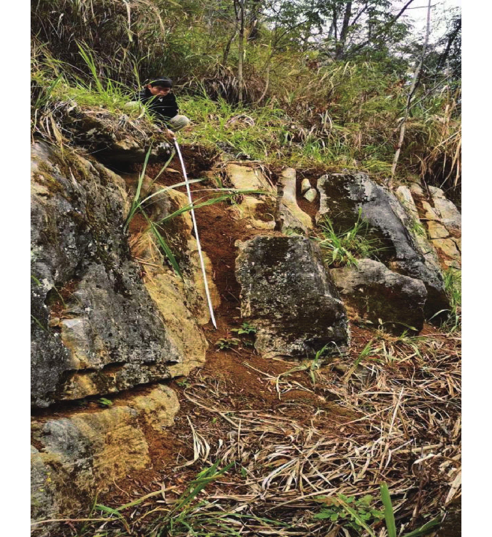
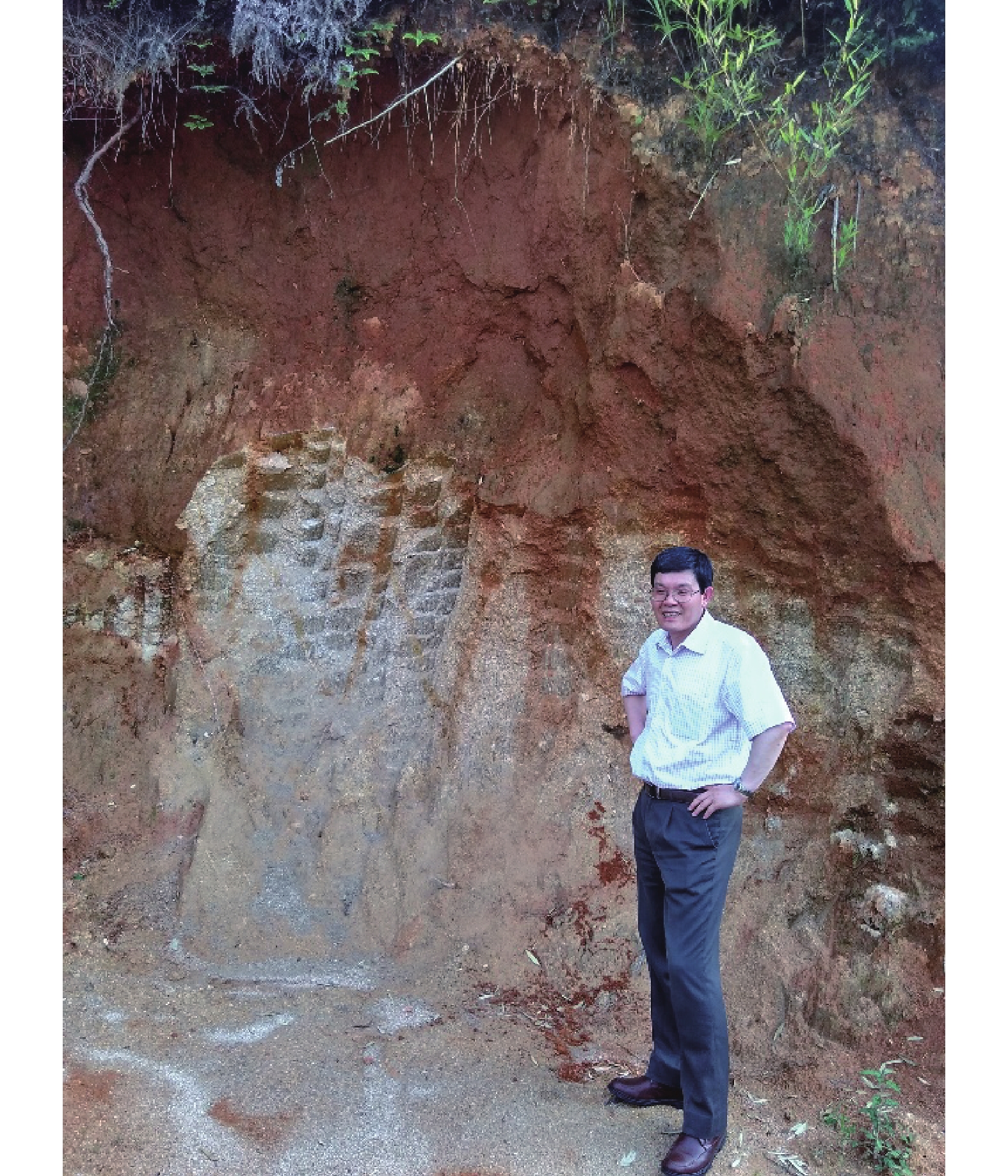
The longstanding debate regarding the origin of pedogenic materials in karst regions—whether derived from in situ weathering of carbonate bedrock or allochthonous inputs—motivated this investigation into soil wedge formation within the karst peak-cluster depression of Huanjiang Guzhou depression, Guangxi, China. To resolve this controversy, we analyzed distributions of natural radionuclides (238U、232Th、226Ra和40K), grain size, bulk density, and pH in a limestone slope soil wedge to trace material sources and elucidate formation mechanisms. Stratified soil samples (0−10, 10−20, 20−40 cm, and 2 m depth) and adjacent limestone bedrock were collected from a 3-m-deep soil wedge (24°55′0.20″N, 107°57′4.35″E), with bulk density measured in situ via the ring-knife method. Grain size distribution was determined using laser diffraction (Mastersizer 2 000) following H2O2 and HCl pretreatment, while radioisotope activities were quantified through low-background γ-spectrometry (HPGe detector, LOAX model) at characteristic energy peaks: 92.8 keV (238U), 583 keV (232Th), 609 keV (226Ra), and 1460 keV (40K). The pH is measured by a pH meter.Results revealed remarkably homogeneous soil physicochemical properties: silt (average 31.81%) and clay (58.82%) dominated the texture, while bulk density (0.94−1.01 g·cm−3) and pH (7.47−8.01) exhibited minimal variation across depths, though the surface layer (0−10 cm) showed slightly lower clay content (27.59%) and higher bulk density (1.01 g·cm−3). Radionuclide activities within the soil wedge demonstrated significant stability: 238U, 232Th, and 226Ra averaged 111.91, 100.17, and 74.03 Bq·kg−1 respectively with negligible depth variation, while 40K activity exhibited a slight increase with depth (average 341.55 Bq·kg−1). Crucially, isotopic ratios remained consistent vertically, with 238U∶ 232Th∶ 226Ra∶ 40K ≈ 1∶0.89∶0.66∶2.86 (0−40 cm) and 1∶0.91∶0.65∶3.76 (2 m), indicating profound vertical homogeneity. In stark contrast, the underlying bedrock exhibited extremely low radionuclide activities: 238U was undetectable (<0.71 Bq·kg−1), while 232Th、26Ra and 40K registered only 2.77, 3.69, and 18.43 Bq·kg−1 respectively, yielding a distinct 232Th∶226Ra∶40K ratio of 1∶1.34∶6.65. The soil-bedrock contrast was unequivocal: 238U activity in the soil (95.72−120.10 Bq·kg−1) exceeded the bedrock level by more than 135 times, and the fundamental difference in 232Th∶ 226Ra∶40K ratios (1∶0.74∶3.41 in soil vs. 1∶1.34∶6.65 in bedrock) provided definitive evidence. This stark geochemical disparity, particularly the absence of 238U and the divergent isotopic signatures in the bedrock, categorically refutes traditional models of residual accumulation via in situ weathering of the underlying pure carbonate limestone, as U/Th series nuclides primarily reside in silicate minerals which are negligible in such bedrock. Instead, the uniform soil texture, stable isotopic ratios across depths, and most critically, the abrupt soil-bedrock contact devoid of any transitional layers, collectively provide robust evidence supporting a formation mechanism driven by gravitational soil creep infilling pre-existing rock fissures.The elevated 238U activity and consistent Th/Ra ratios within the soil wedge point towards external material sources, likely comprising weathered residues from interbedded clastic layers within the mid-upper slopes and/or contributions from aeolian dust, analogous to the Saharan dust inputs documented in Mediterranean Terra Rossa formations. This mechanism stands in clear global context: unlike granitic weathering crusts characterized by gradual transitions through distinct weathering horizons (e.g., soil → strongly weathered layer → weakly weathered layer → fresh bedrock), limestone soil wedges exhibit sharp, unconformable interfaces-a definitive hallmark of allochthonous infilling. While this aligns with the formation paradigm of Mediterranean Terra Rossa, it fundamentally contrasts with models proposing in situ karst weathering. Integrated evidence thus conclusively confirms that soil wedges in karst peak-cluster depressions form primarily through the gravitational infilling of rock fissures by externally sourced materials, not through the in-situ weathering of the immediate limestone substrate. Radionuclide activity ratios, particularly the highly diagnostic 238U /232Th contrast, serve as powerful tracers for discerning pedogenic sources in such complex terrains. These findings necessitate a redefinition of karst soil evolution paradigms, significantly underscoring the critical role of aeolian and slope-wash transported alluvial inputs in shaping subtropical karst ecosystems.
Study on the distribution of uranium content in cave stalagmites in China and its influencing factors
PEI Wen, HUANG Fuyuan, YIN Jianjun, TANG Xiangling
2026, 45(1): 7-22. doi: 10.11932/karst2025y011
Abstract:
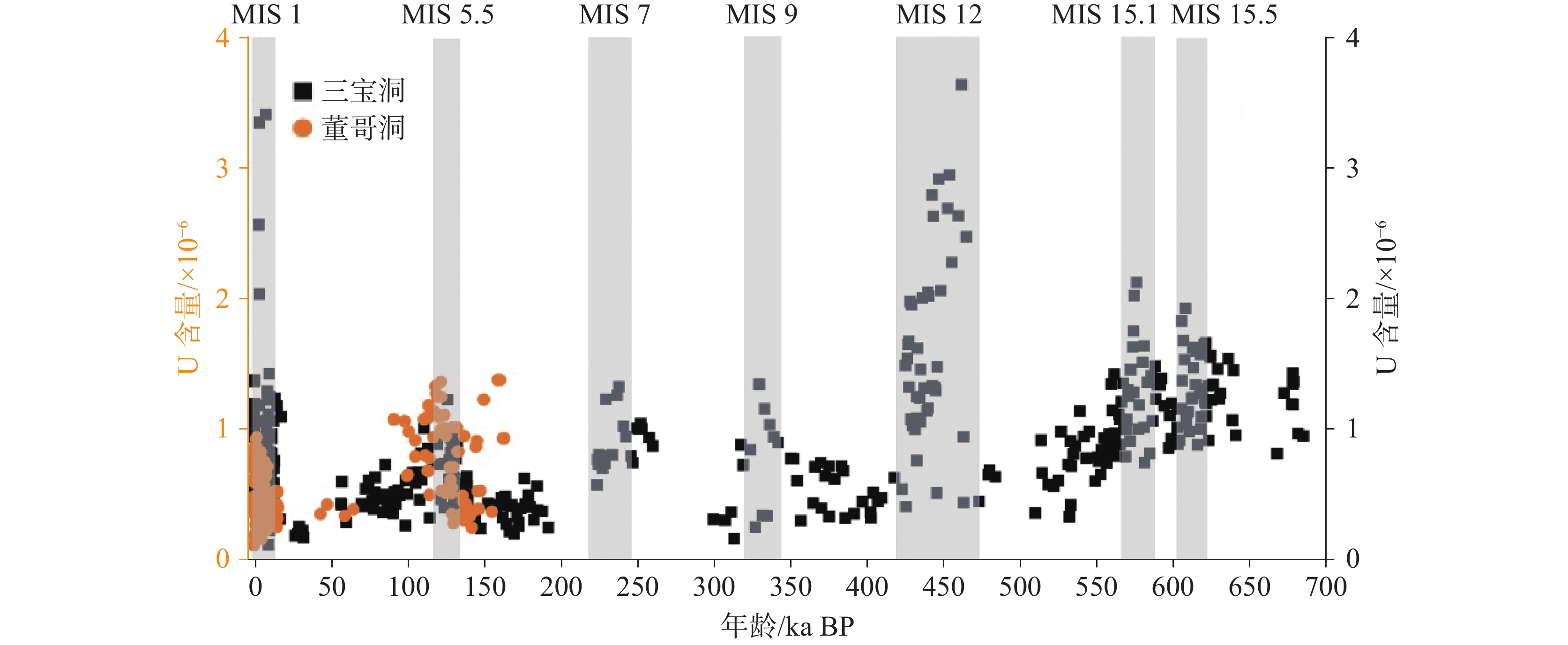
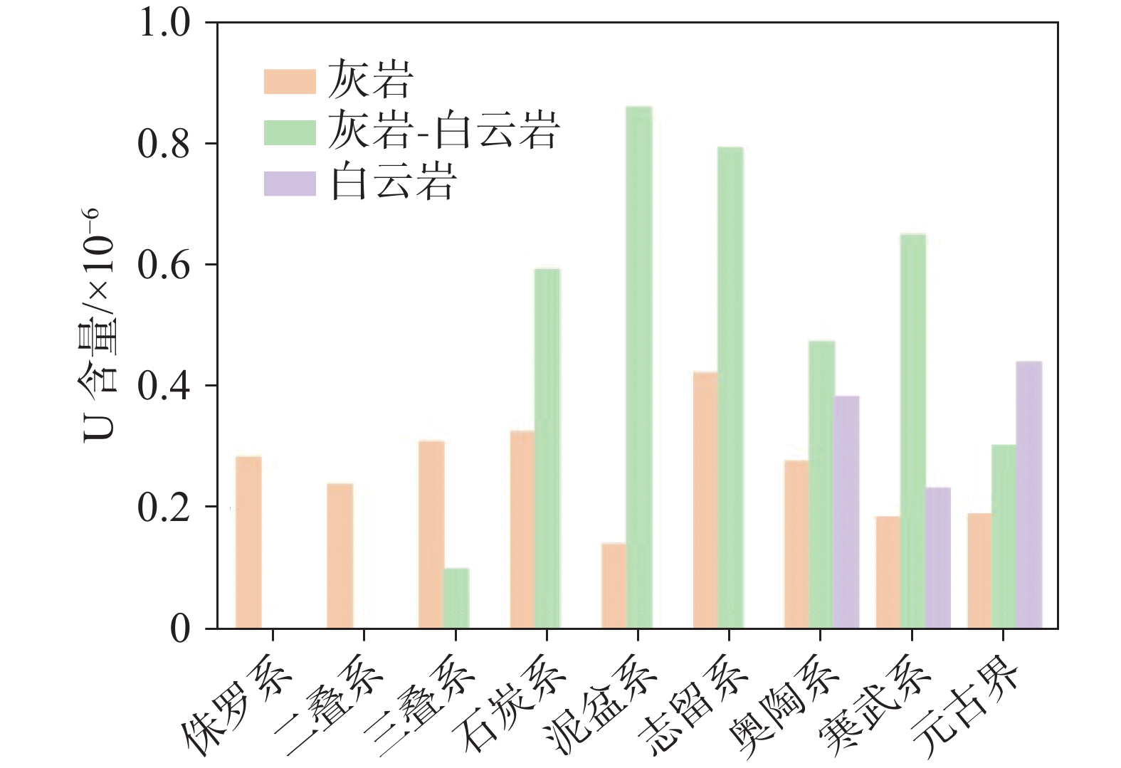
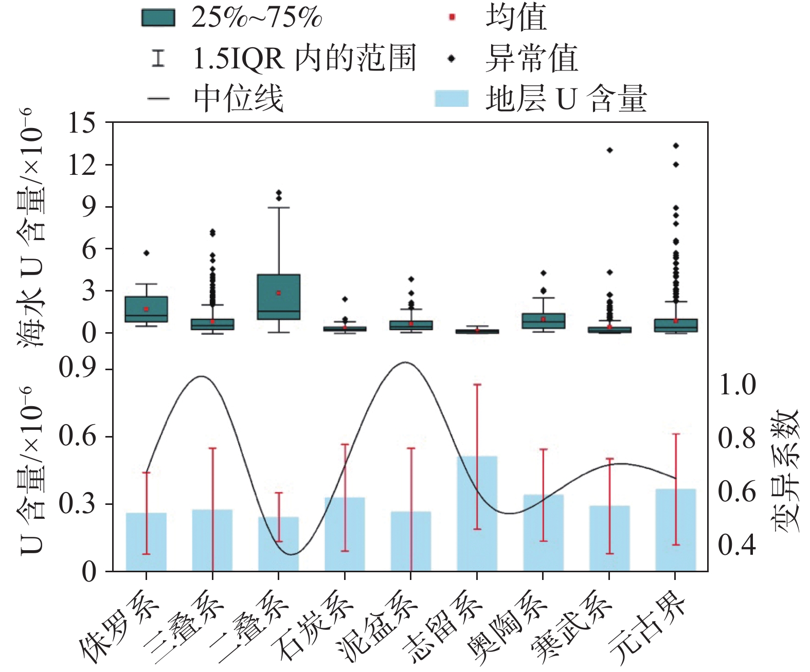
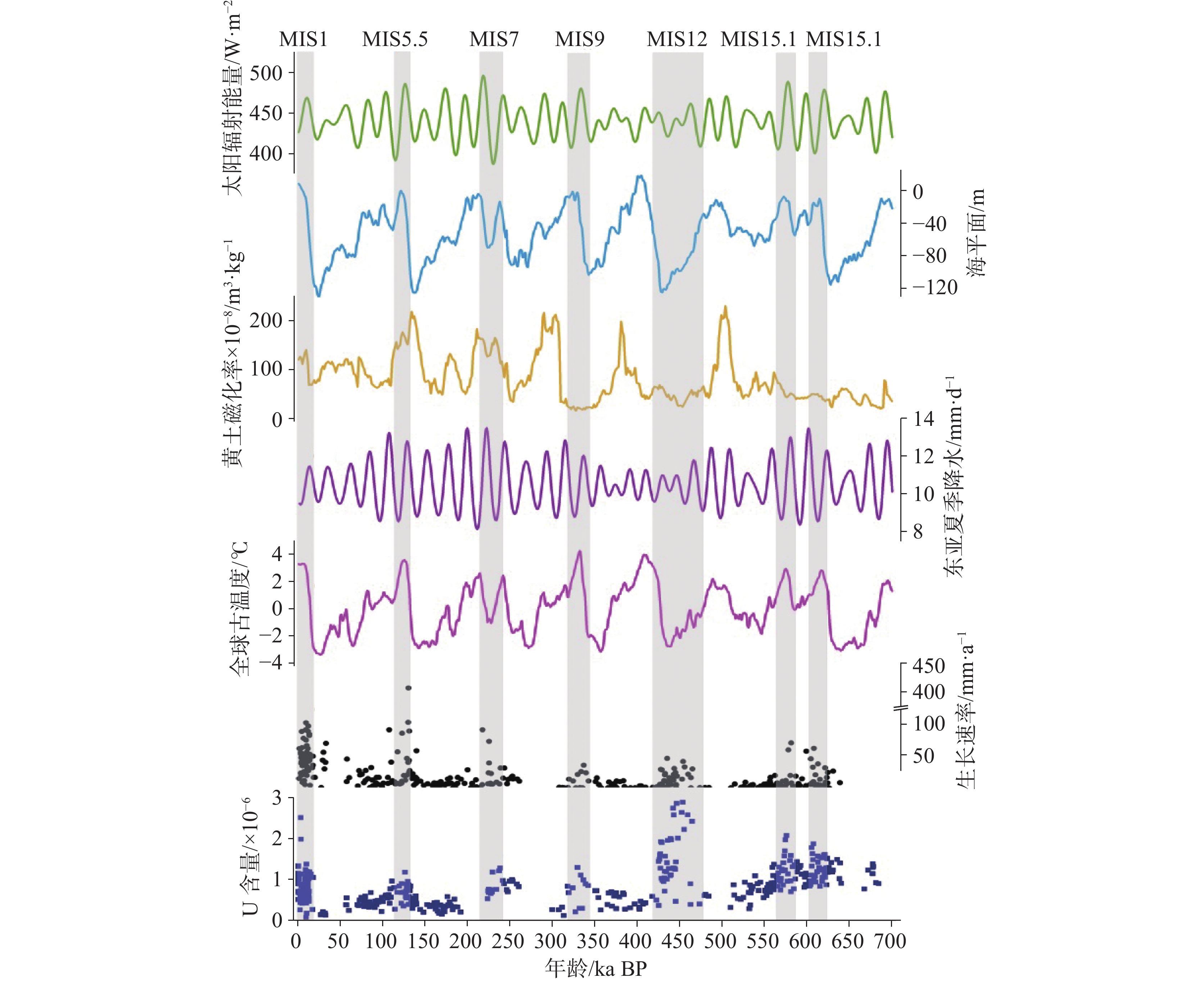
The uranium content of stalagmites is the foundation of stalagmite chronology research. It directly determines whether a stalagmite sample is suitable for paleoclimate research and affects the accuracy and precision of stalagmite dating results. Currently, two uranium-series dating techniques are commonly used for stalagmites: U-Th dating and U-Pb dating. The U-Th method can date samples up to approximately 690,000 years old, while the U-Pb method extends the dating range to the Paleozoic or even earlier geological periods. However, the reliability of both methods is highly dependent on the uranium concentration in the stalagmites. Stalagmite samples with low uranium content often result in large age uncertainties, which can lead to significant misinterpretations of the timing and duration of past abrupt climatic events, thereby compromising the accuracy of paleoclimate reconstructions. Therefore, investigating the factors that influence uranium concentrations in stalagmites is of great significance both theoretically and practically. Such understanding can help identify high-uranium stalagmite samples, enhance dating precision, and ultimately support the establishment of more robust chronological frameworks. Nevertheless, current knowledge of the mechanisms controlling uranium content in stalagmites remains limited. Most existing studies focus on the climatic significance of uranium concentration and initial (234U/238U) ratios in stalagmites. Previous studies have shown that the uranium content in stalagmites is influenced by factors such as soil, surrounding rock, the infiltration path of karst water, and the duration of water-rock interaction; While, systematic large-scale studies that integrate these factors are still lacking. In China, karst landscapes are widely distributed, and stalagmite records have played a vital role in high-resolution paleoclimate studies. However, there are relatively few comprehensive analyses on the temporal and spatial distribution characteristics of uranium content in cave stalagmites, as well as the influencing factors. This study aims to explore the temporal and spatial distribution characteristics of uranium content in cave stalagmites in China and the key influencing factors. The goal is to provide a scientific basis for selecting suitable stalagmite samples with adequate uranium concentrations, thereby minimizing unnecessary use and waste of valuable stalagmite resources.This study collects and analyzes the data from 114 published cave stalagmite samples in China. By examining the spatial distribution and temporal evolution of uranium concentrations, the study explores the roles of regional tectonic background, host rock lithology, mineralogy of the stalagmite, and the hydroclimatic conditions under which the stalagmites formed. The main research objectives are: (1) Clarifying the spatial distribution pattern and temporal variation characteristics of uranium content in Chinese stalagmites; (2) Identifying the primary controlling factors, including geological settings, mineral composition, and environmental parameters; (3) Providing scientific criteria for selecting suitable samples for uranium-series dating, thereby avoiding unnecessary waste of stalagmite resources.The analysis of the research results indicates: (1) The spatial distribution of karst caves in China is regionally distinct. Although they are widely distributed, most caves develop on the second geomorphic step and in tectonically active zones such as the Qinling-Dabie orogenic belt and the monsoon-affected regions east of the Hu Line. The warm and humid climate conditions are conducive to the development of karst caves; (2) Based on published Chinese stalagmite records, uranium concentrations typically range from 0.5×10⁻⁶ to 10×10−6. High-uranium stalagmites (1×10⁻⁶ to 10×10−6) are mainly found in karst caves developed in Mesozoic or older limestone formations located in the junction regions of Guizhou, Chongqing, Hubei, and Hunan; (3) The lithology of host rocks is a critical factor influencing uranium enrichment. When stalagmites are composed of calcite, those formed in dolomite tend to have higher uranium contents than those formed in limestone. This may be attributed to differences in rock weathering processes, inter-crystalline porosity, and water-rock interaction time; (4) The presence of dolomite within the host rock or geological strata appears to be an important contributor to elevated uranium levels in aragonite stalagmites; (5) Uranium concentrations are significantly correlated with regional hydroclimate conditions. There is a positive relationship between uranium content and stalagmite growth rate: stalagmites formed under warm and humid conditions generally contain higher uranium levels, whereas those formed under cold and arid conditions tend to have lower uranium concentrations; (6) In general geological settings, the primary source of uranium in sedimentary strata is ancient seawater, thus creating a link between uranium content in stalagmites and that in paleo-seawater. However, in certain specialized geological environments, such as coal-bearing formations or areas with magmatic intrusions, localized uranium enrichment in bedrock can lead to abnormally high uranium levels in stalagmites.This study enhances our understanding of the variability and controlling mechanisms of uranium concentration in stalagmites under different lithological, stratigraphic, and climatic conditions. The findings provide both theoretical insights and practical guidelines for selecting high-uranium stalagmite samples, thereby supporting the continued advancement of stalagmite-based paleoclimate reconstructions.
Characteristics of soil organic carbon changes in abandoned farmland of yellow soil and limestone soil in karst area
HE Hao, YANG Jing, DENG Zhihao
2026, 45(1): 23-36, 63. doi: 10.11932/karst2025y022
Abstract:
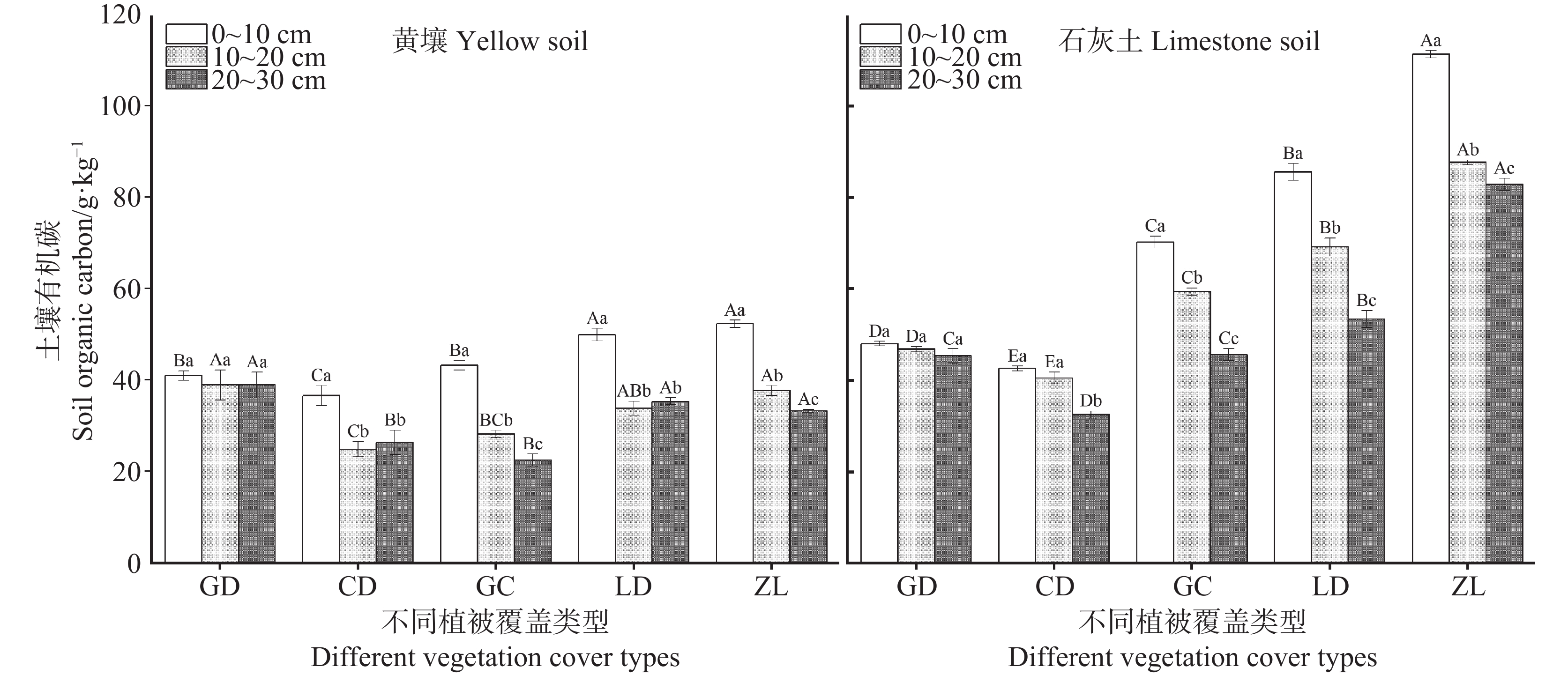
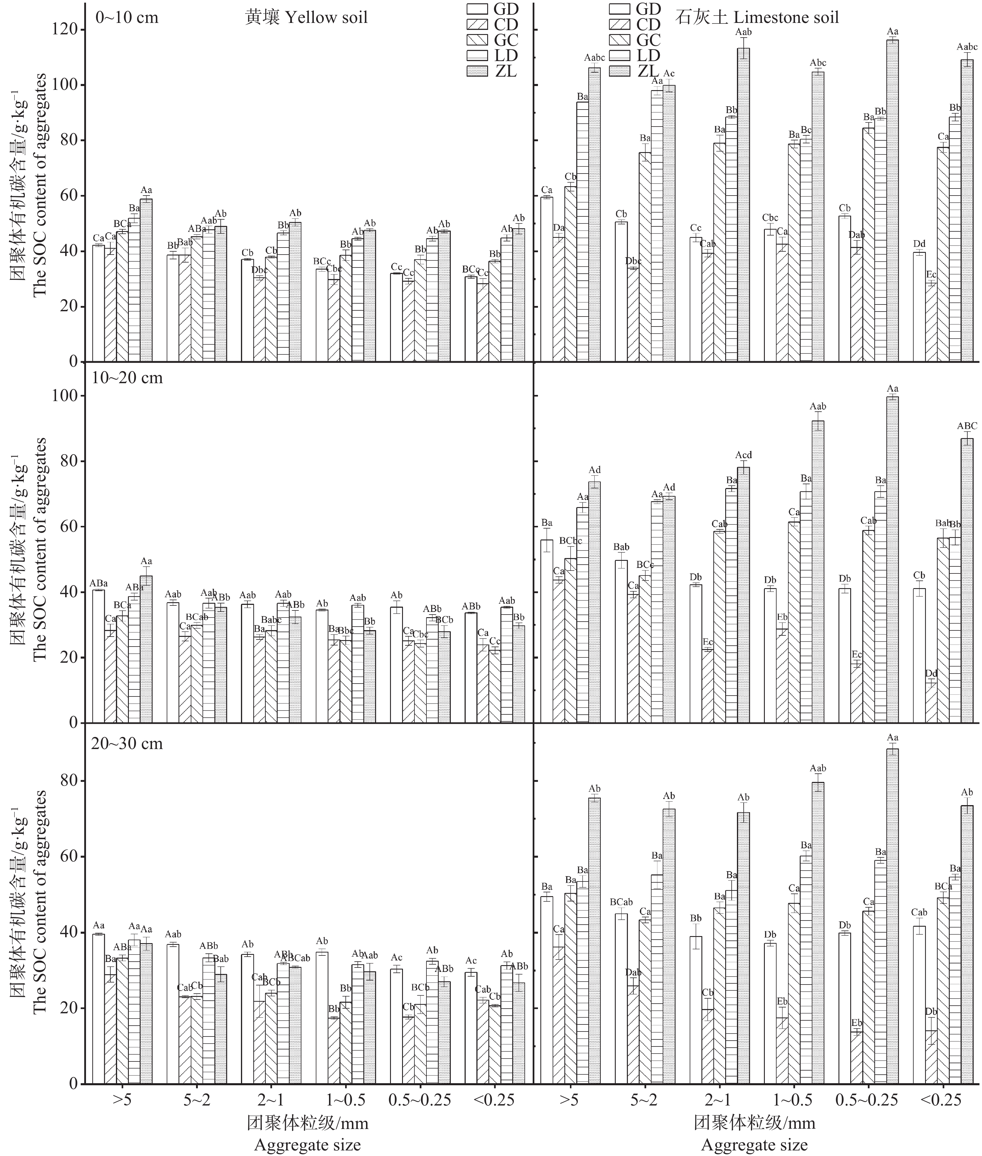
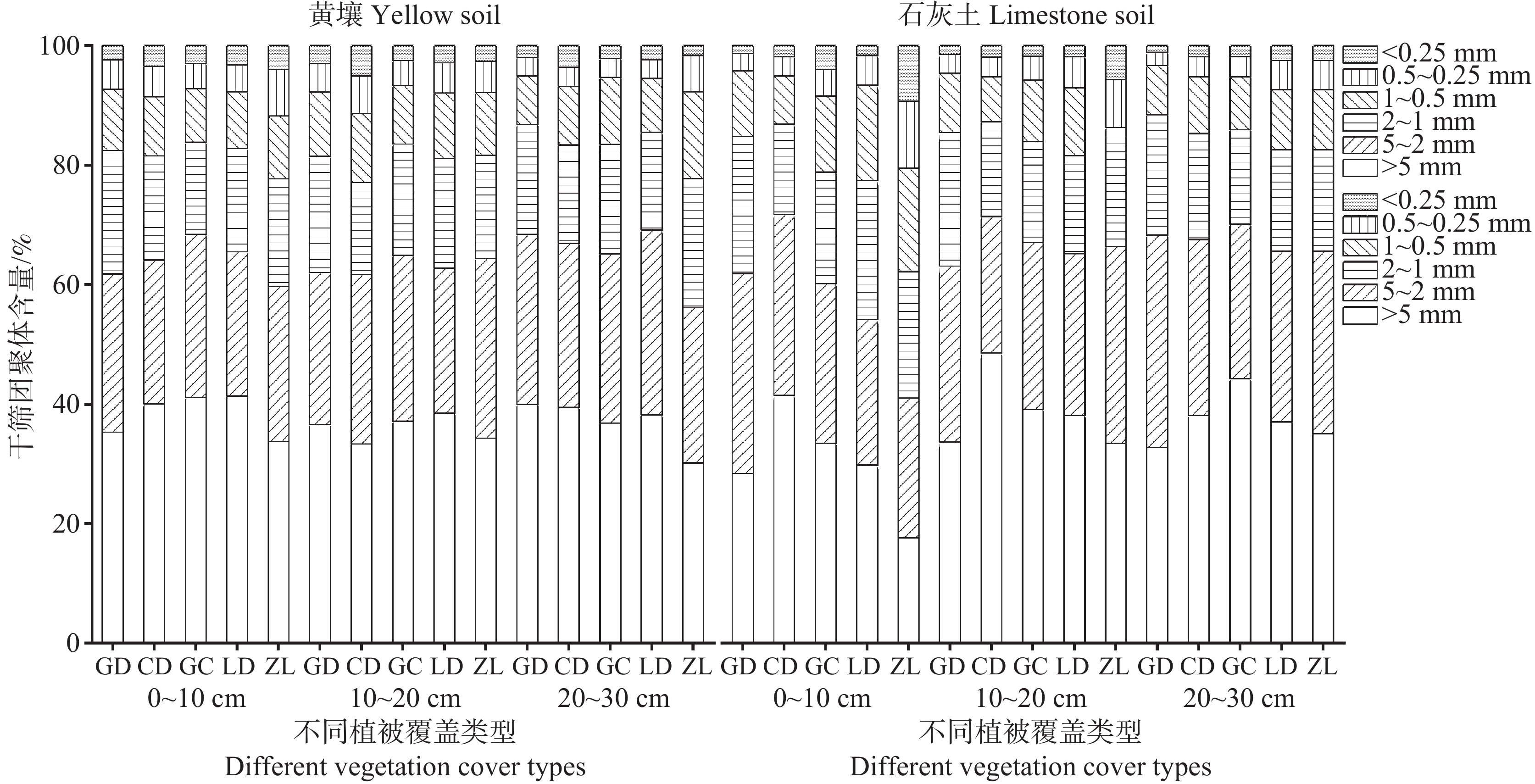
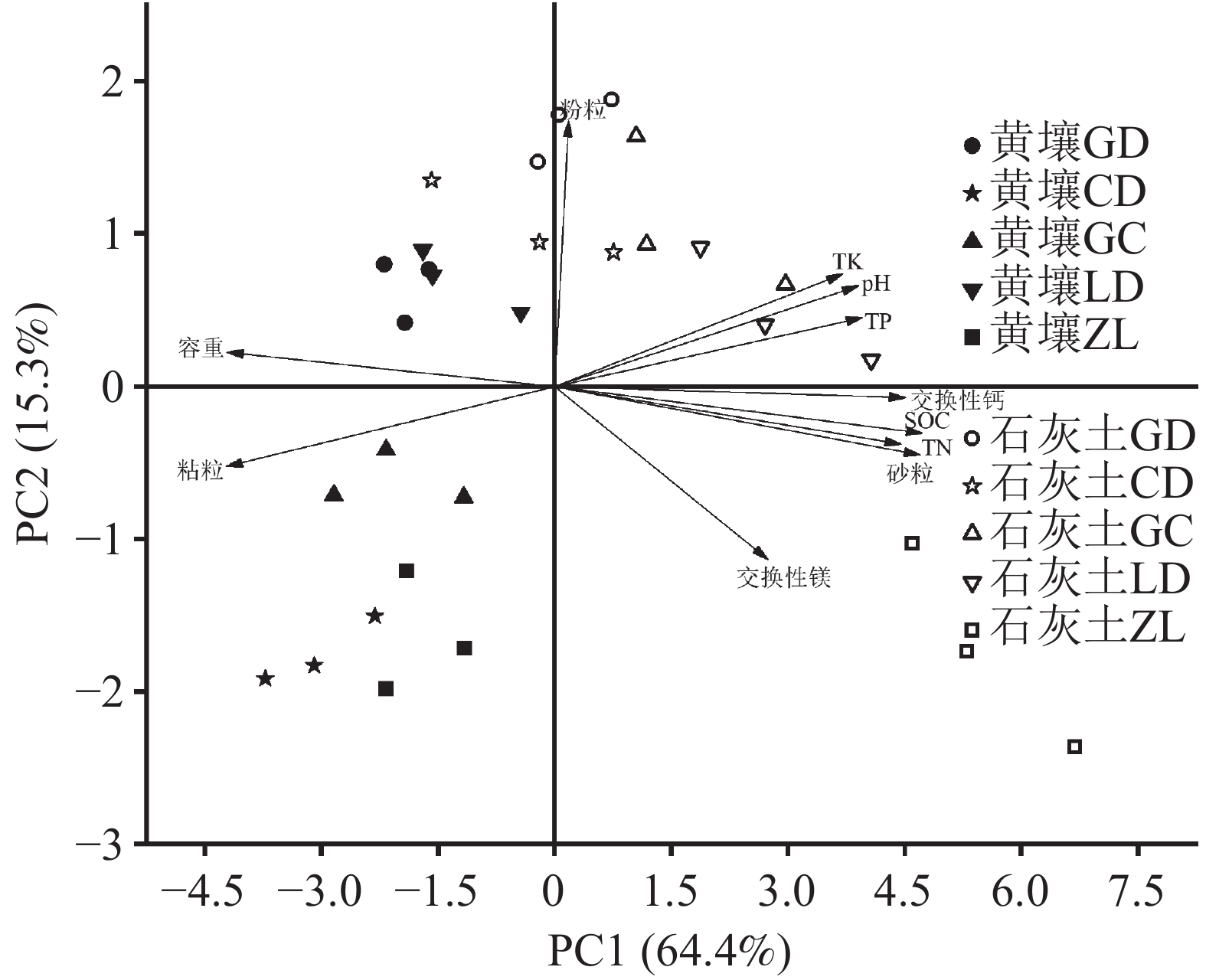
This study investigates the variation characteristics of Soil Organic Carbon (SOC) content and SOC in different aggregate fractions across various vegetation restoration stages in abandoned croplands, providing a theoretical basis for ecological restoration. Focusing on five succession stages (cropland, grassland, shrubland, forestland, and natural forestland) in yellow soil and limestone soil of the karst area in Guizhou, we analyzed the characteristics of SOC changes at the 0-30cm soil layer and in aggregates of different particle sizes across the five stages.The results showed that SOC significantly increased (P < 0.05) from grassland to forestland in both soil types. At all succession stages, limestone soil exhibited higher SOC than yellow soil, with the highest SOC observed in the 0−10 cm layer of forestland (85.50 g·kg−1 in limestone soil vs. 49.95 g·kg−1 in yellow soil). In later succession stages, the SOC growth rate of forestland compared to that of the cropland was significantly higher in limestone soil (48.48%) than in yellow soil (0.24%). Grassland SOC was significantly lower than cropland SOC in both soil types (P < 0.05). With progressive succession, SOC content in different aggregate fractions increased to varying degrees, consistently higher in limestone soil than in yellow soil. Across all vegetation types, large aggregates (>2 mm) contained higher SOC than smaller fractions. The >2 mm aggregate fraction contributed the most to SOC storage (34.74% in yellow soil, 53.02% in limestone soil). Correlation analysis revealed that in yellow soil, SOC was significantly positively correlated with exchangeable calcium (Ca), total nitrogen (N), and total potassium (K) (P < 0.01), and negatively correlated with bulk density (P < 0.05). In limestone soil, SOC showed strong positive correlations with exchangeable Ca, magnesium (Mg), TN, total phosphorus (P), and sand content (P < 0.01), while negatively correlating with bulk density, silt, and clay (P < 0.05). Principal Component Analysis (PCA) indicated clear differentiation among grassland, shrubland, and cropland in yellow soil, whereas limestone soil exhibited less distinct separation among the three abandoned vegetation types and cropland. Overall, returing farmland to vegetation helps improve soil quality, alleviates soil compaction, and enhances soil organic carbon storage. Limestone soil demonstrates greaterr carbon sequestration benefits compared to yellow soil.
Spatiotemporal evolution and driving factors of ecosystem service trade-offs and synergies in the upper reaches of the Yangtze River Basin
SU Yongbiao, LIU Weiguo
2026, 45(1): 37-50. doi: 10.11932/karst20260102
Abstract:
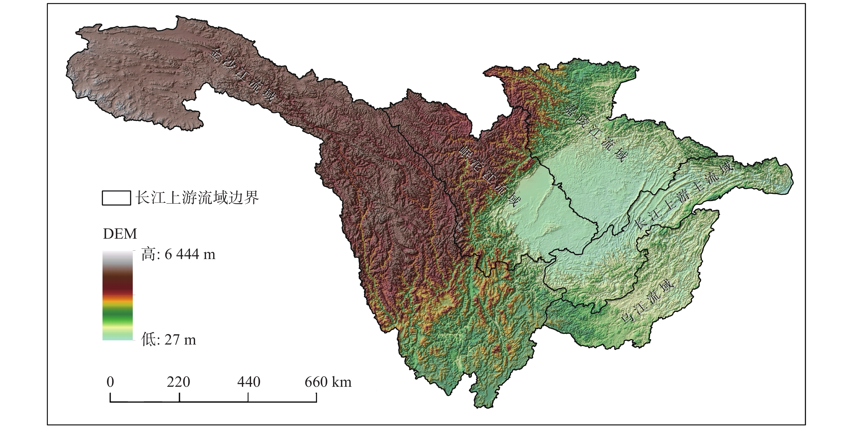
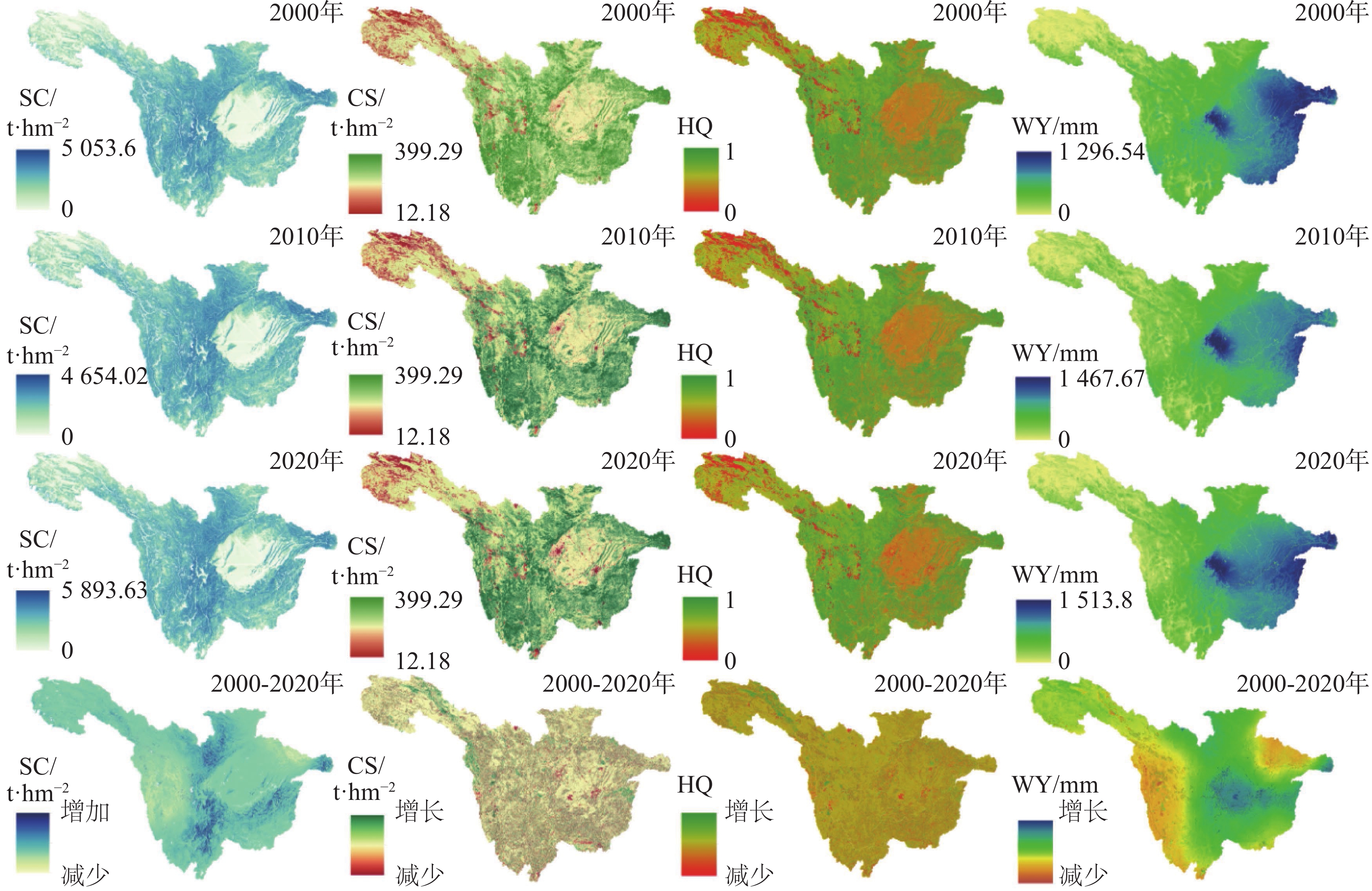
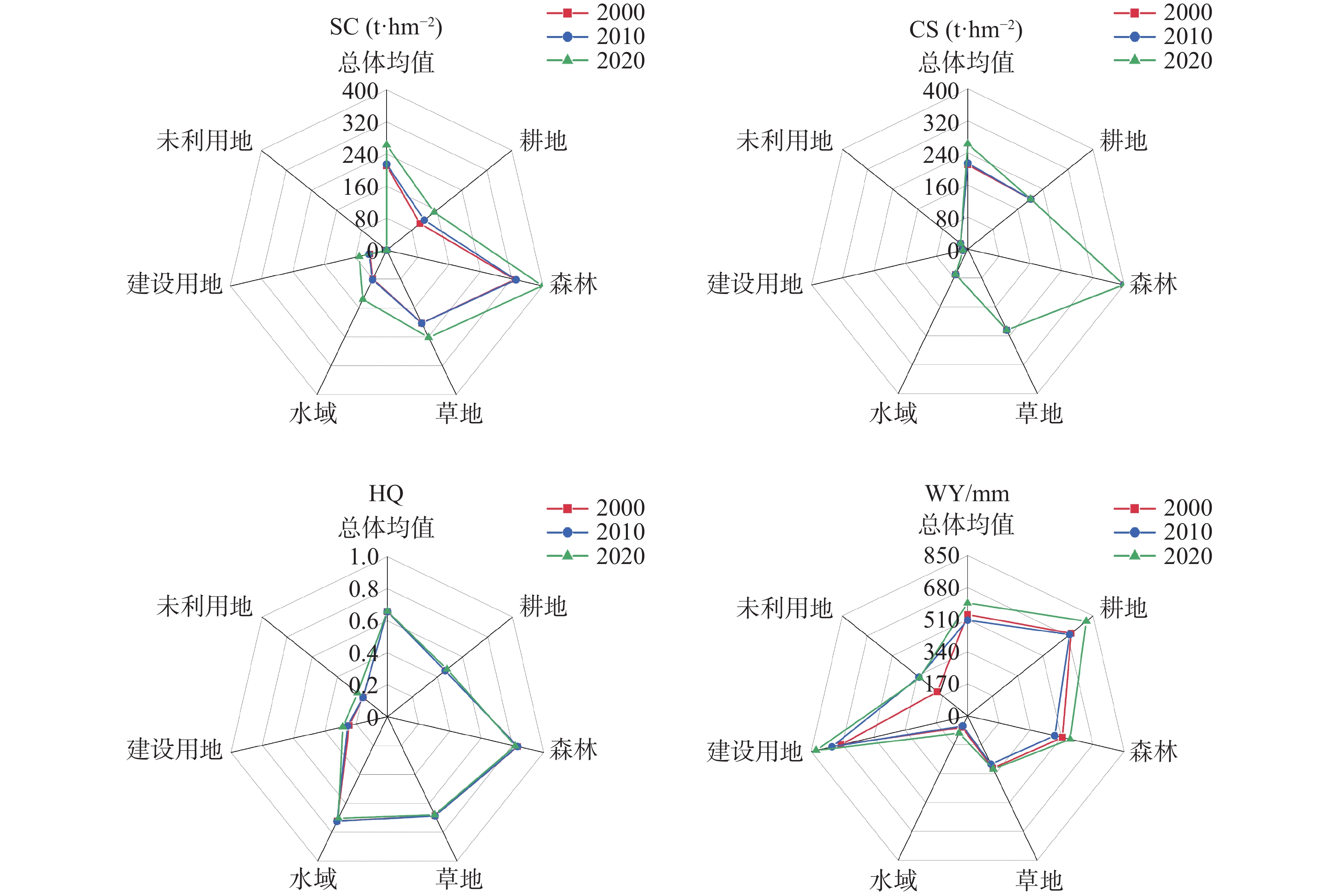
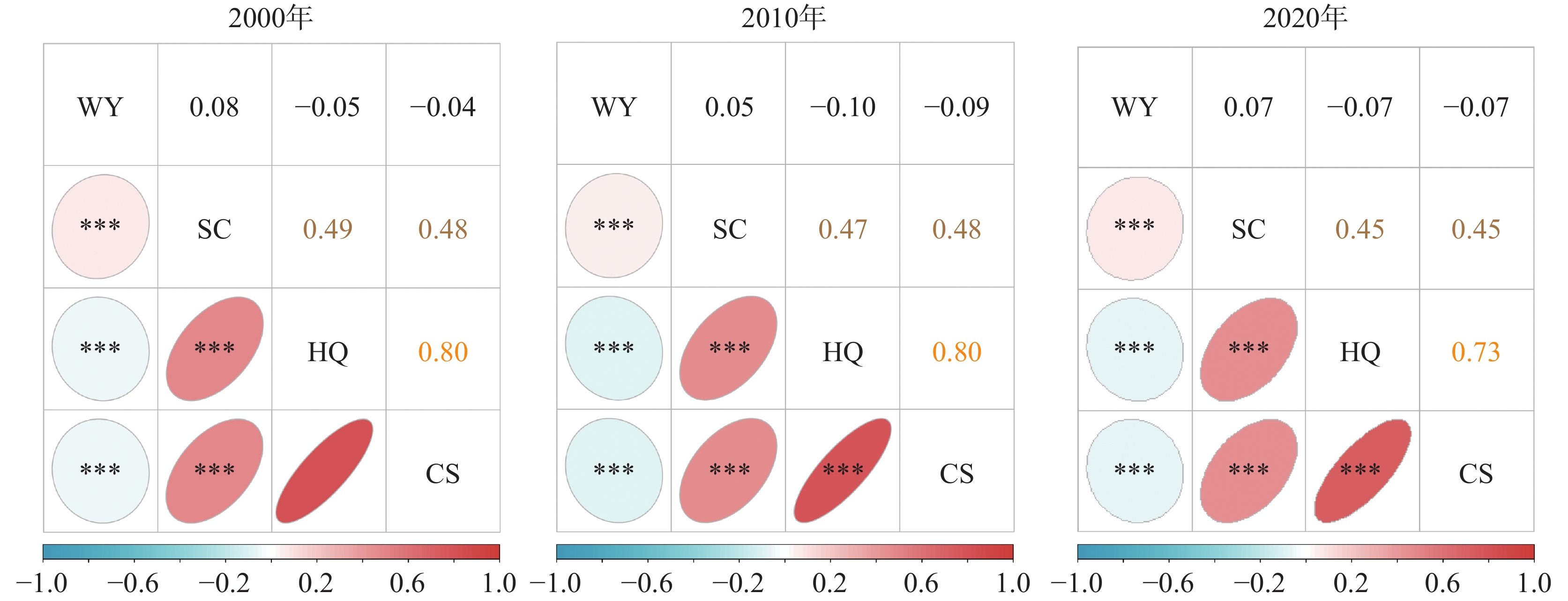
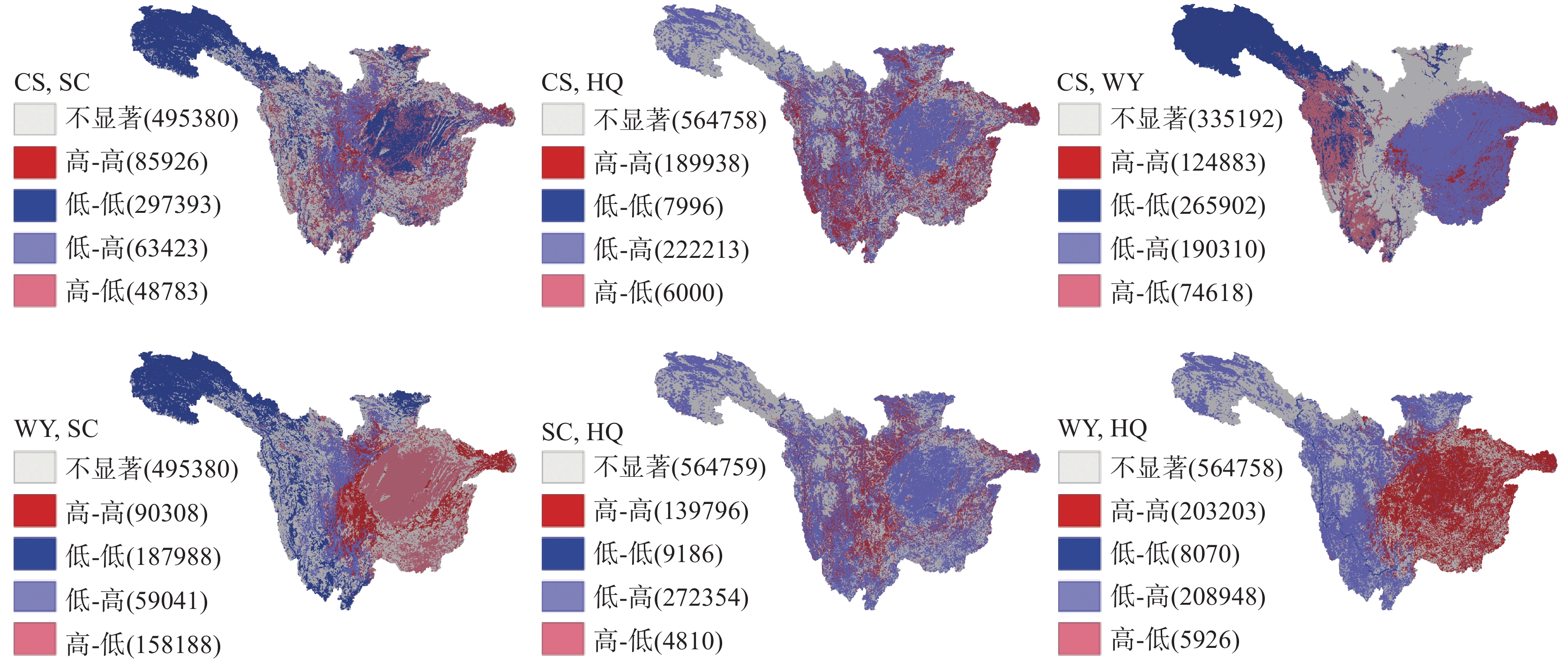
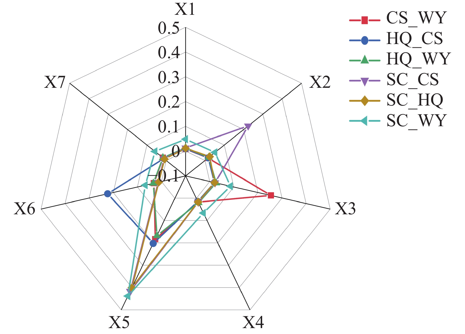
Understanding the spatiotemporal dynamics of Ecosystem Services (ESs), uncovering the trade-offs and synergies among different services, and identifying their driving mechanisms are of great significances for the effective management of ecosystems and regional sustainable development. This study focuses on the upper reaches of the Yangtze River Basin, assessing the spatiotemporal evolution of four key ESs-Water Yield (WY), Carbon Storage (CS), Soil Conservation (SC), and Habitat Quality (HQ)-from 2000 to 2020. The Spearman correlation coefficient and bivariate spatial autocorrelation analysis were employed to quantify the trade-offs and synergies among ESs and their spatial distribution patterns, while the geographical detector model was used to reveal their driving factors. The results indicate: (1) From 2000 to 2020, the average WY, SC, CS, and HQ in the study area were 547.33 mm, 229.20 t·hm−2, 264.0 t·hm−2, and 0.66, respectively. Over this period, WY, CS, and HQ showed an increasing trend at the regional scale, while SC remained relatively stable. Spatially, SC and WY exhibited a gradual increase from west to east, whereas CS and HQ displayed higher values in the southwestern and northern regions, with lower values in the central and northwestern areas. (2) The trade-offs and synergies among ESs demonstrated significant spatial heterogeneity. Synergistic relationships were observed between WY-SC, SC-HQ, SC-CS, and HQ-CS, while trade-offs were identified between WY-HQ and WY-CS. Spatially, the synergistic and trade-off relationships of WY-SC, WY-CS, CS-HQ, and SC-HQ showed similar geographical patterns, with synergies dominant in the northwestern and central regions and trade-offs prevalent in the western and southern areas. In contrast, the trade-offs between WY-HQ and CS-SC were primarily concentrated in the central plain region. (3) The spatial heterogeneity of ES trade-offs and synergies was driven by multiple factors. Among these, topographic and climatic factors were identified as the key drivers, with the interaction between climate and topography exhibiting particularly significant explanatory power. This interaction not only reveals the nonlinear effects among natural elements, but also further highlights the importance of multi-factor coupling driving forces wthin complex geographic enbironments. The study reveals that the interactions among ESs are not only influenced by their intrinsic relationships, but also co-regulated by external factors such as climate and topography.This study elucidates the influencing mechanisms by natural factors (climate, topography) and anthropogenic activities to the spatiotemporal heterogeneity of ES trade-offs and synergies in the upper Yangtze River Basin. The findings provide a scientific basis for the sustainable management of regional ecosystems and will offer valuable insights for policymakers to formulate differentiated ecological conservation strategies.
Resource endowment and conservation value of the karst area in Southwestern Guangxi
SU Hongxin, QIN Xingming, CHEN Weicai, HUANG Shengmin, YANG Yuanzheng, XU Zhanyong, HU Baoqing, CAI Huide, LU Feng
2026, 45(1): 51-63. doi: 10.11932/karst20260103
Abstract:
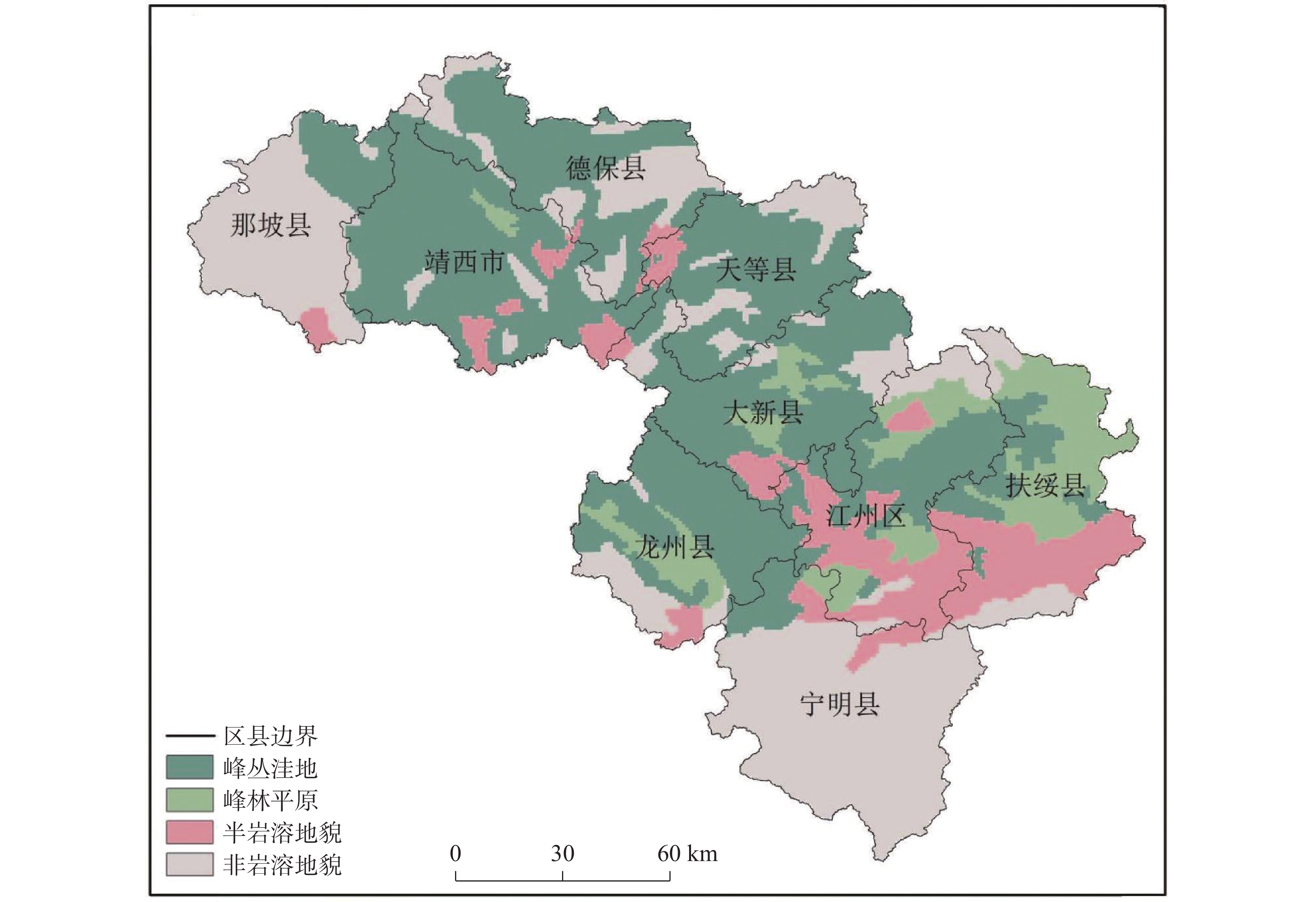
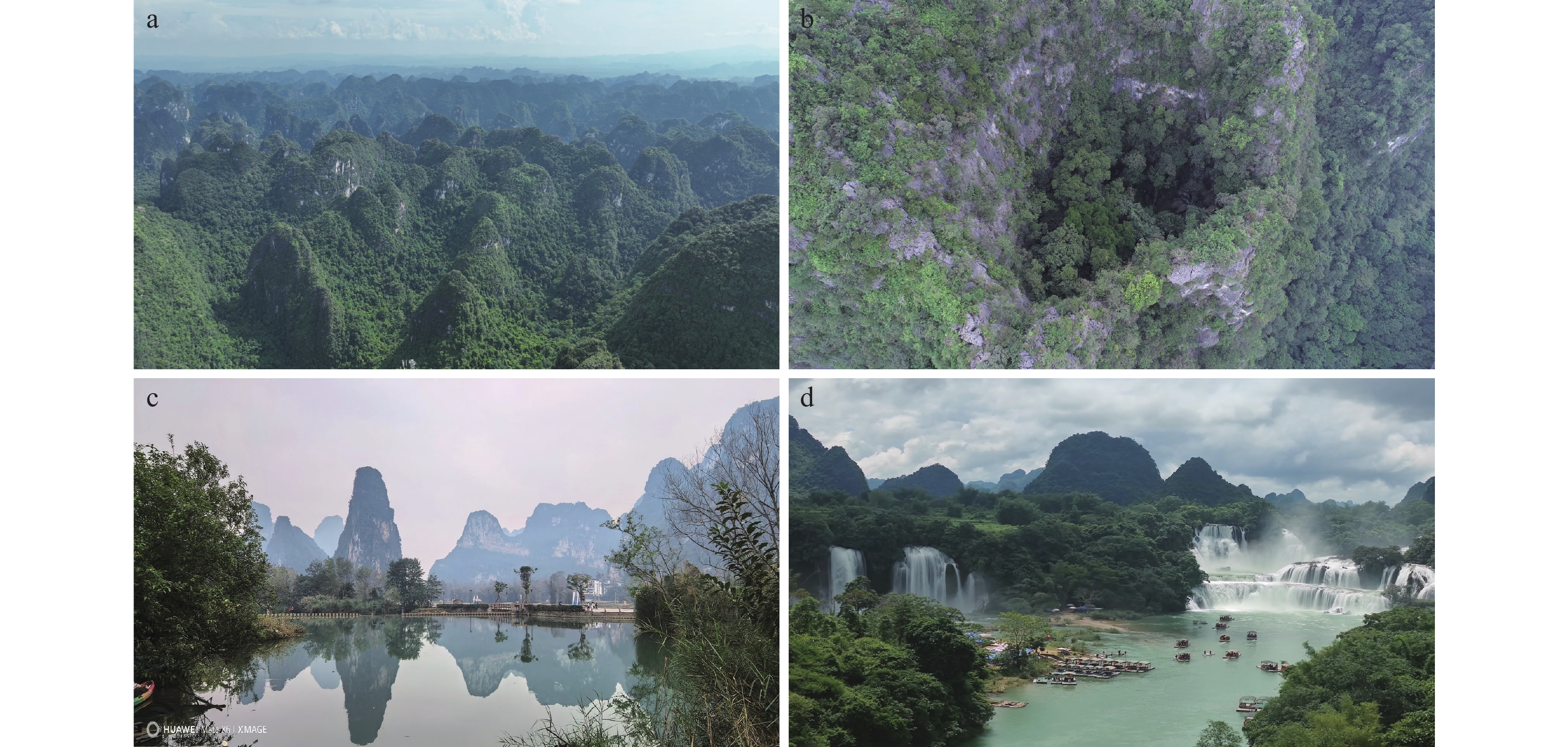
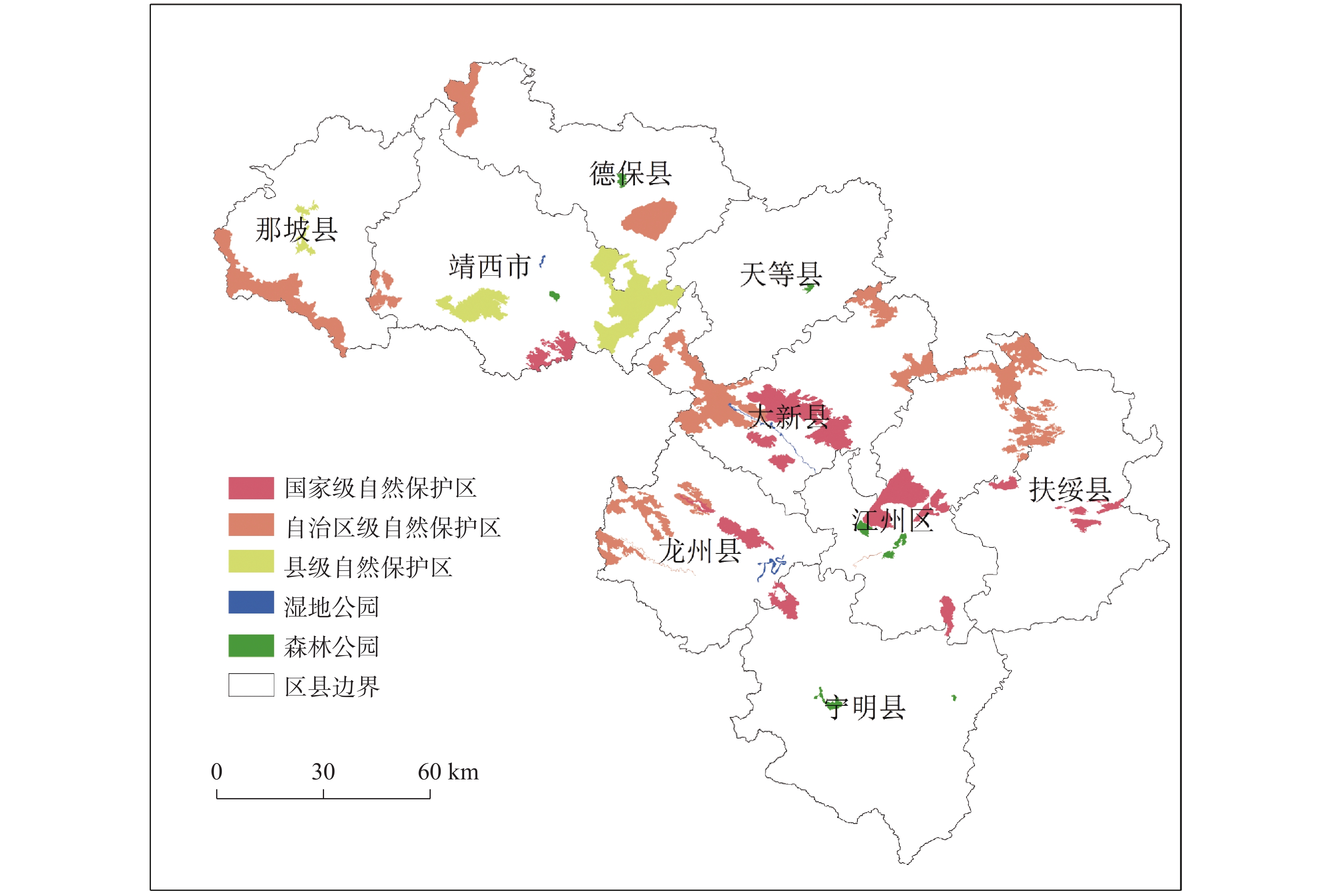
Natural reserves serve as the core carrier of ecological conservation and play a pivotal role in safeguarding national ecological security. The southwest of Guangxi Zhuang Autonomous Region, bordering Vietnam, experiences a tropical and southern subtropical monsoon climate and features extensively distributed typical tropical and subtropical karst landforms, including peak-cluster depressions, peak-forest plains, sinkhole groups, caves, and canyons. Notably, this region preserves large-areas of northern tropical limestone mountain seasonal rainforests, which are rare both in China and globally. Boasting high integrity and good authenticity, this forest ecosystem provides favorable habitats for flagship species such as plants of the Cycas and Taxus genera, as well as Parashorea chinensis, Excentrodendron hsienmu, Nomascus nasutus, Trachypithecus francoisi, and Trachypithecus poliocephalus.This region harbors exceptionally rich biodiversity. A total of 695 wild vertebrate species have been documented, including 36 species endemic to China, 18 listed as Class Ⅰ national key protected wild animals, and 69 as Class Ⅱ. Additionally, there are 4,262 wild vascular plant species belonging to 1,349 genera of 254 families. Among these plants, 1,171 are endemic to China, 16 are Class Ⅰ national key protected wild plants, and 56 are Class Ⅱ. As part of the Indo-Burma Biodiversity Hotspot, this region serves as a global concentration site for the most endangered primates, is one of the three major centers of plant endemism in China, and is a priority area for biodiversity conservation in the mountainous regions of Southwestern Guangxi. Inhabited by ethnic minorities, it is home to a World Cultural Heritage site-the Zuojiang Huashan Rock Art Cultural Landscape, and also boasts abundant revolutionary tangible and intangible heritage, such as the Baise Uprising Memorial Hall and the Zuoyoujiang Revolutionary Base Area, thereby serving as an important part of the community for the Chinese nation. Furthermore, it functions as a vital node for consolidating the ecological security barrier along the China-Vietnam border and for building a community with a shared future for all life on Earth.Based on the relevant requirements for establishing and developing the system of natural reserves, this study conducts assesses and concludes that the karst region in Southwestern Guangxi holds exceptional conservation value in terms of national representativeness, ecological significance, and cultural uniqueness. This study particularly emphasizes the integrated and systematic protection of the karst ecosystem in this region, recommending that the Forestry Bureau of the Autonomous Region take the lead in establishing an extensive cooperation mechanism among governments, universities, research institutes, and enterprises. Furthermore, it suggests integrating the natural reserves in the karst region within Southwestern Guangxi to establish the Natural Reserve Alliance of Southwestern Guangxi.This study addresses the challenges facing the karst region in Southwestern Guangxi, including inadequate coverage of natural reserves, significant contradictions between ecological protection and economic development, and insufficient innovation capacity for cultural preservation and inheritance. It proposes targeted measures such as further advancing the integration and optimization of natural reserves, establishing an integrated monitoring system, implementing ecological restoration projects, promoting the integration of culture and tourism with science popularization and education, strengthening cross-border ecological cooperation, and achieving comprehensive ecosystem protection. These initiatives aim to promote the coordinated development of ecological protection and economic growth, continuously strengthen the protection of the region's core values, consolidate the ecological security barrier along the China-Vietnam border, achieve greater progress in the high-quality development of border and ethnic minority areas, and make more contributions to safeguarding national security.
Study on the impact and threshold effect of rural population decline on plant diversity in Southwest China
LUO Qing, ZHAO Cuiwei, LUO Guangjie, RAN Chen, ZHANG Sirui, XIONG Lian, DU Chaochao, LI Minghui, SHEN Xiaoqian, YANG Shu, ZHANG Xiaoyun, BAI Xiaoyong
2026, 45(1): 64-80. doi: 10.11932/karst20260104
Abstract:
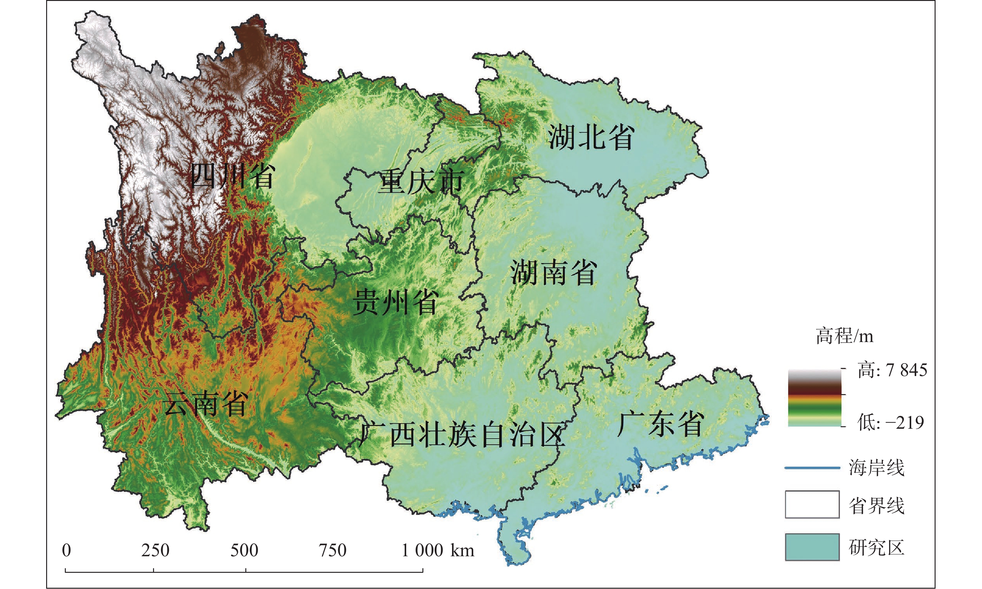
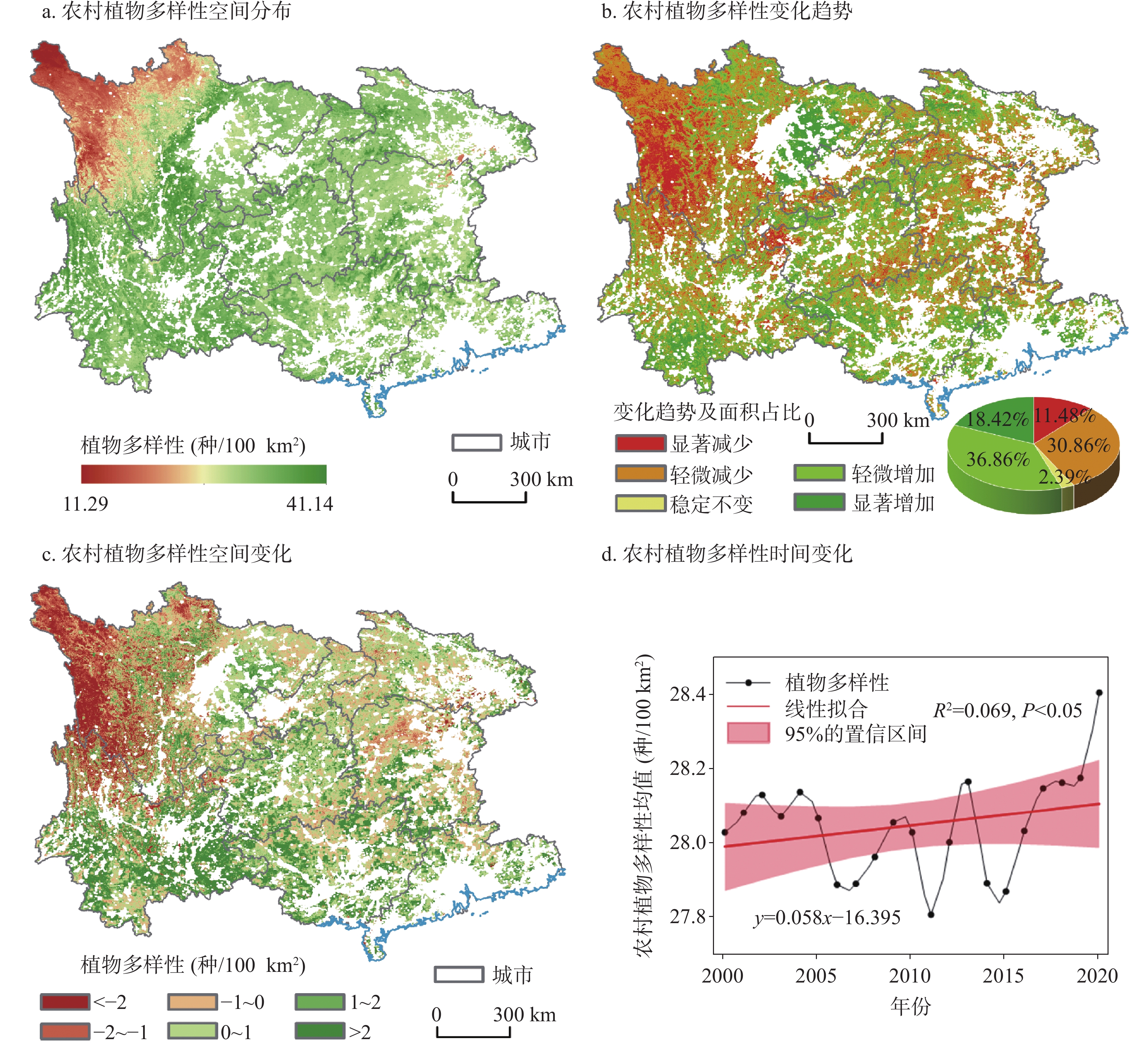
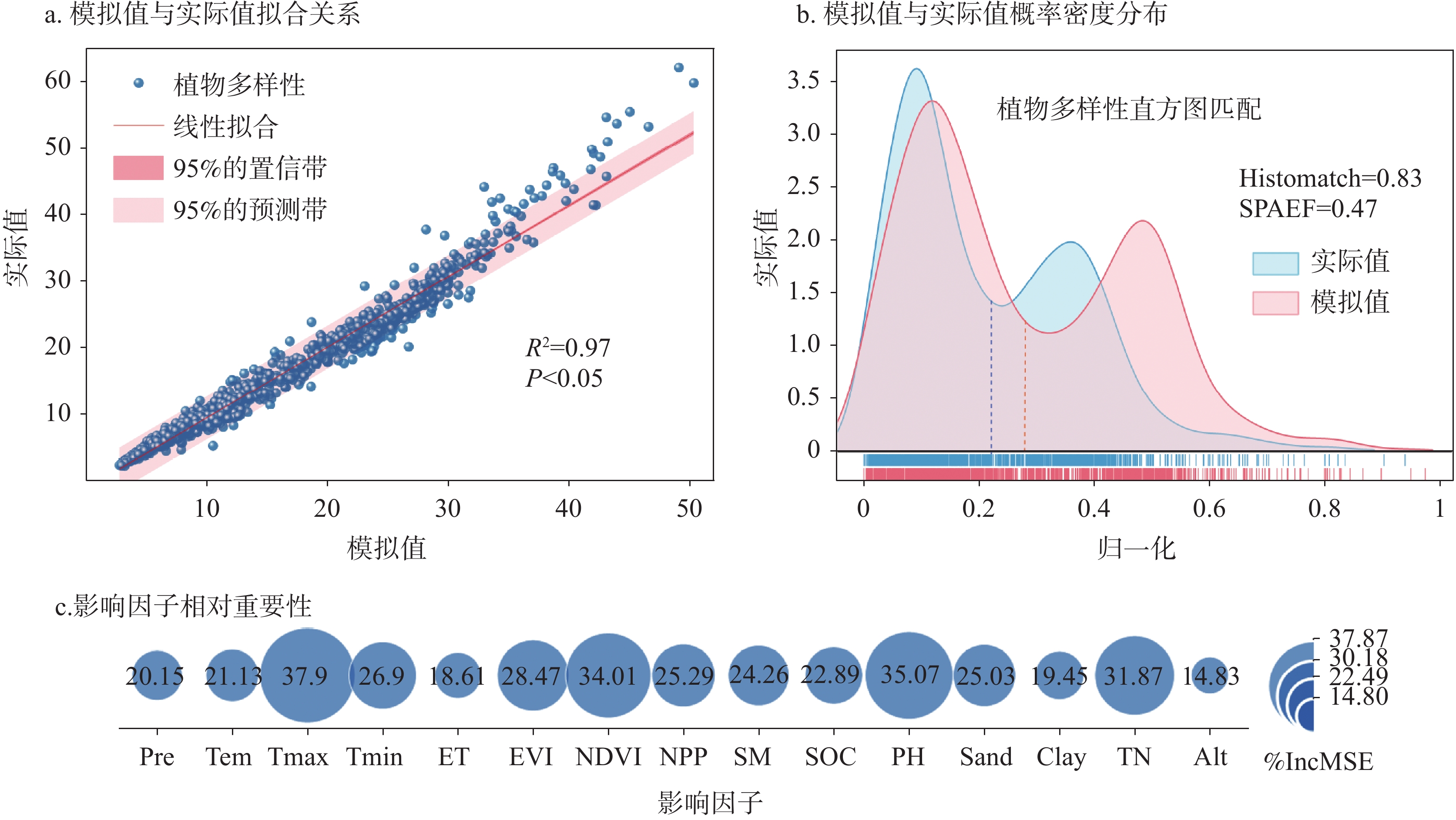
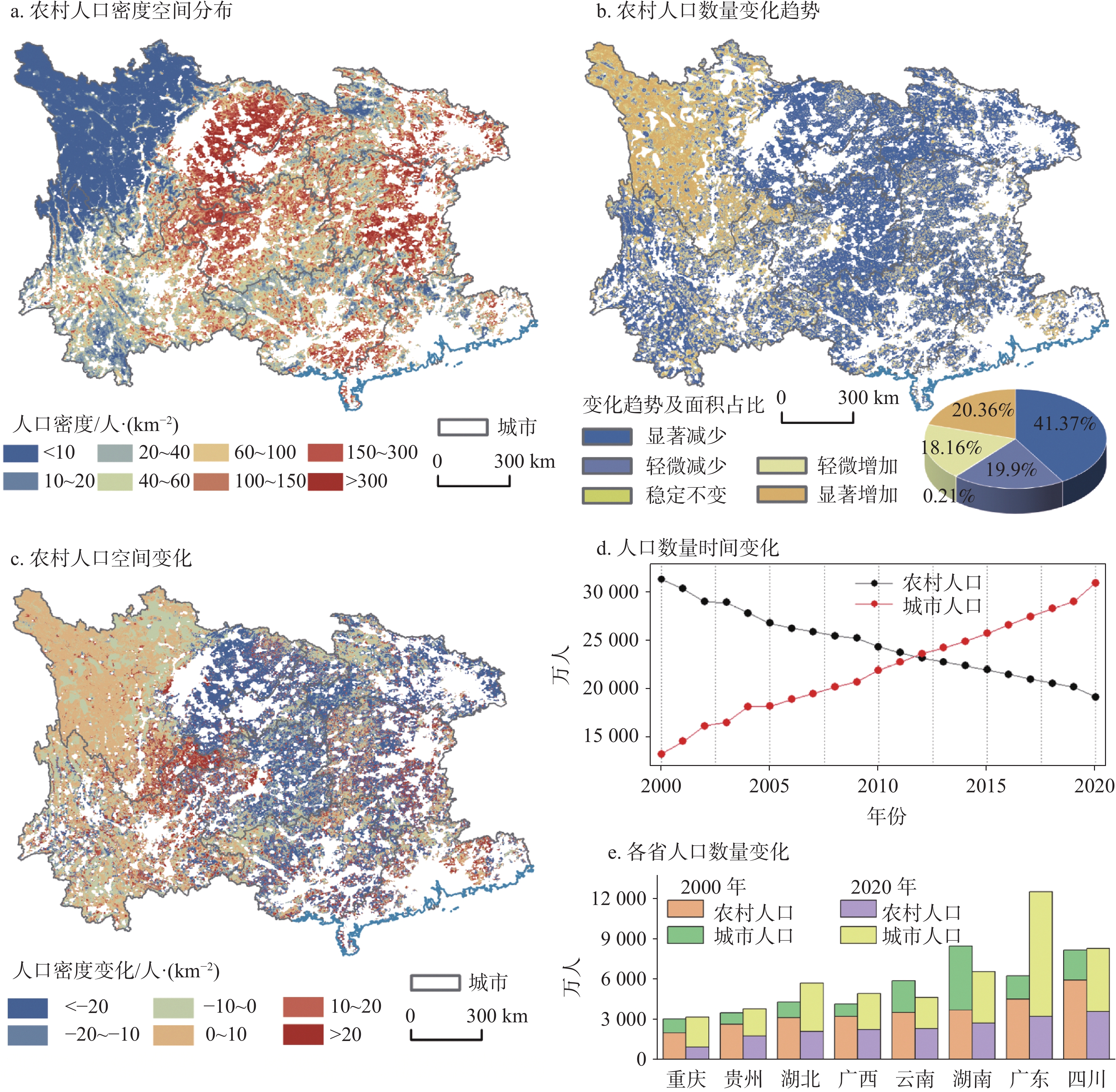
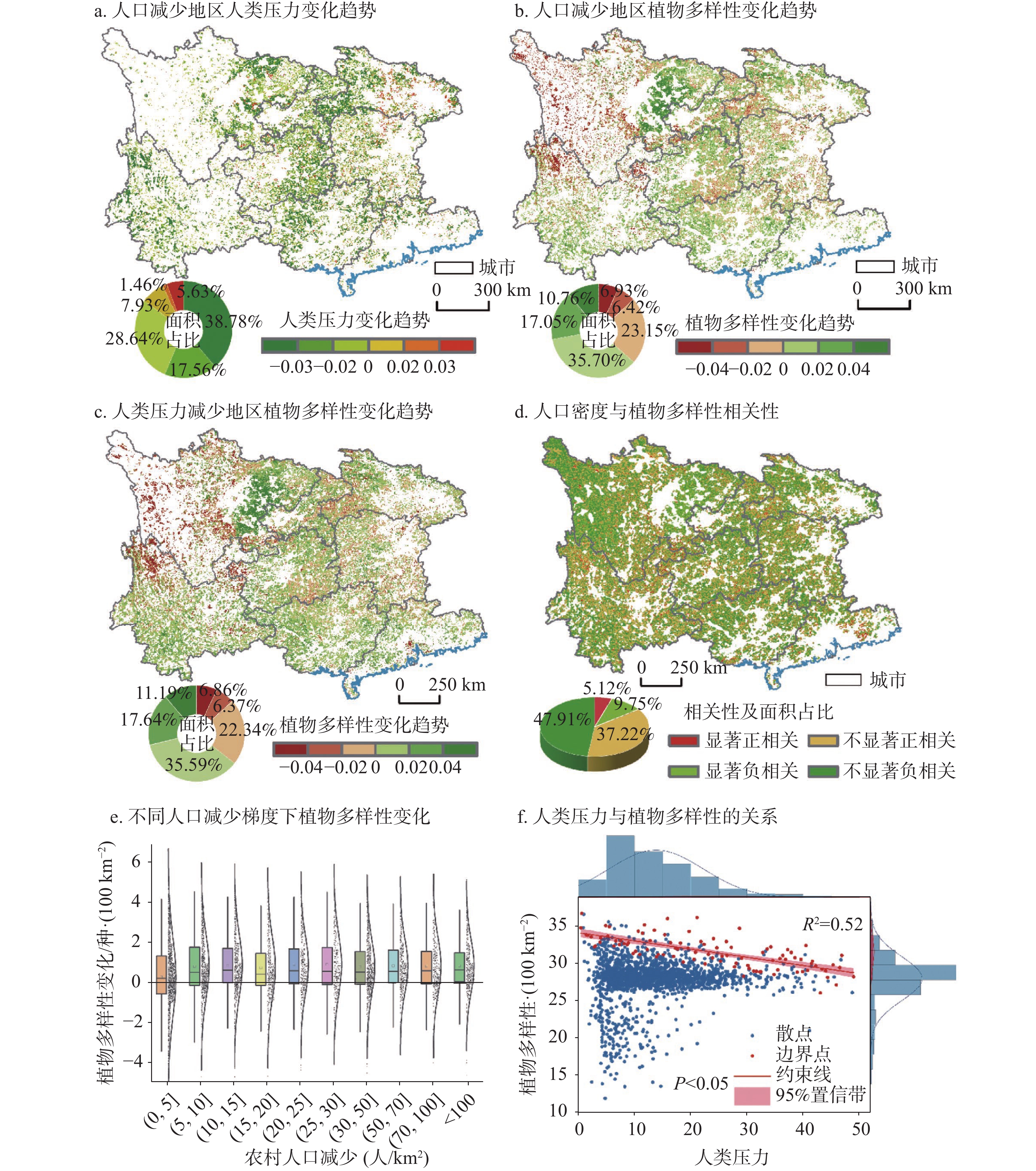
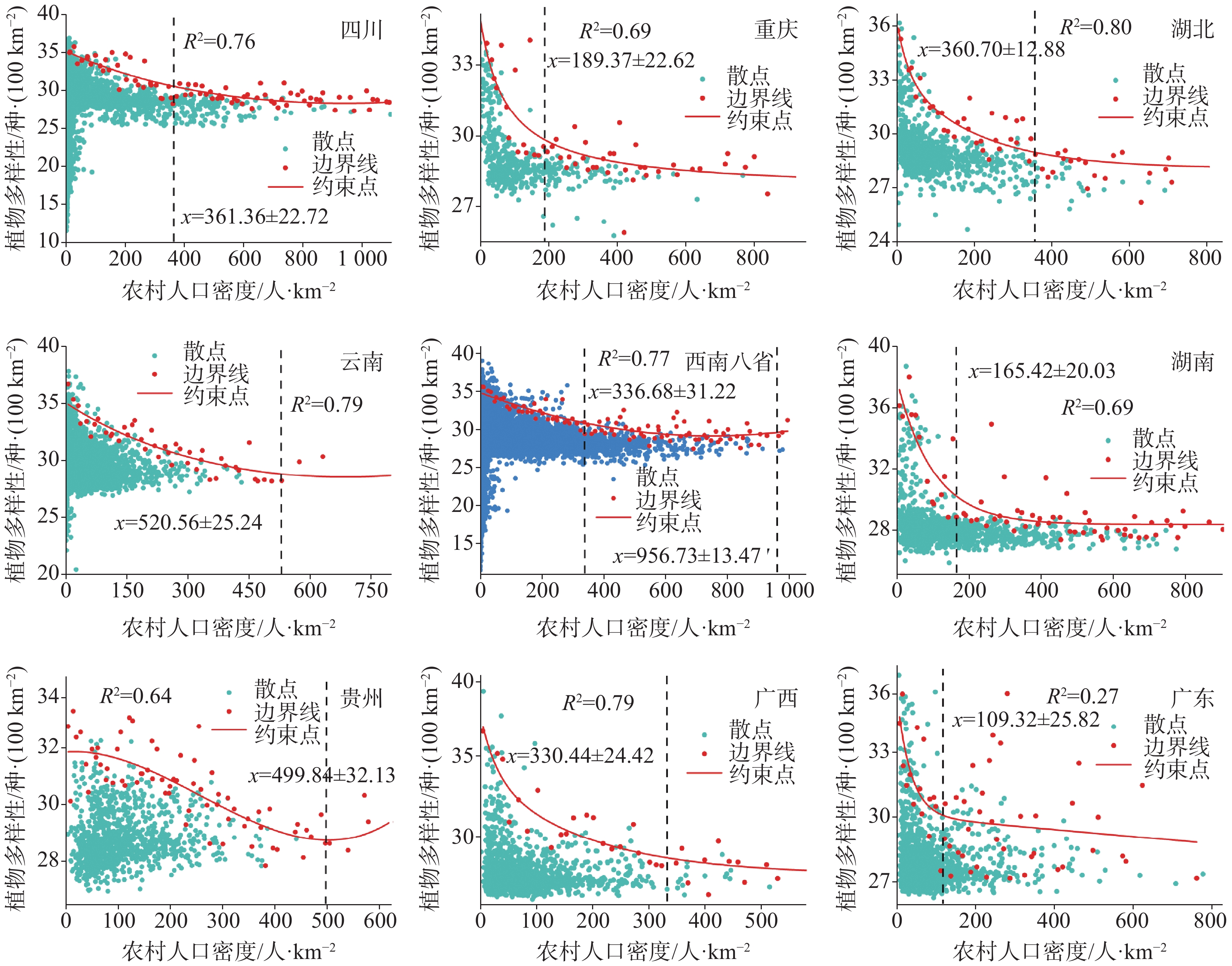
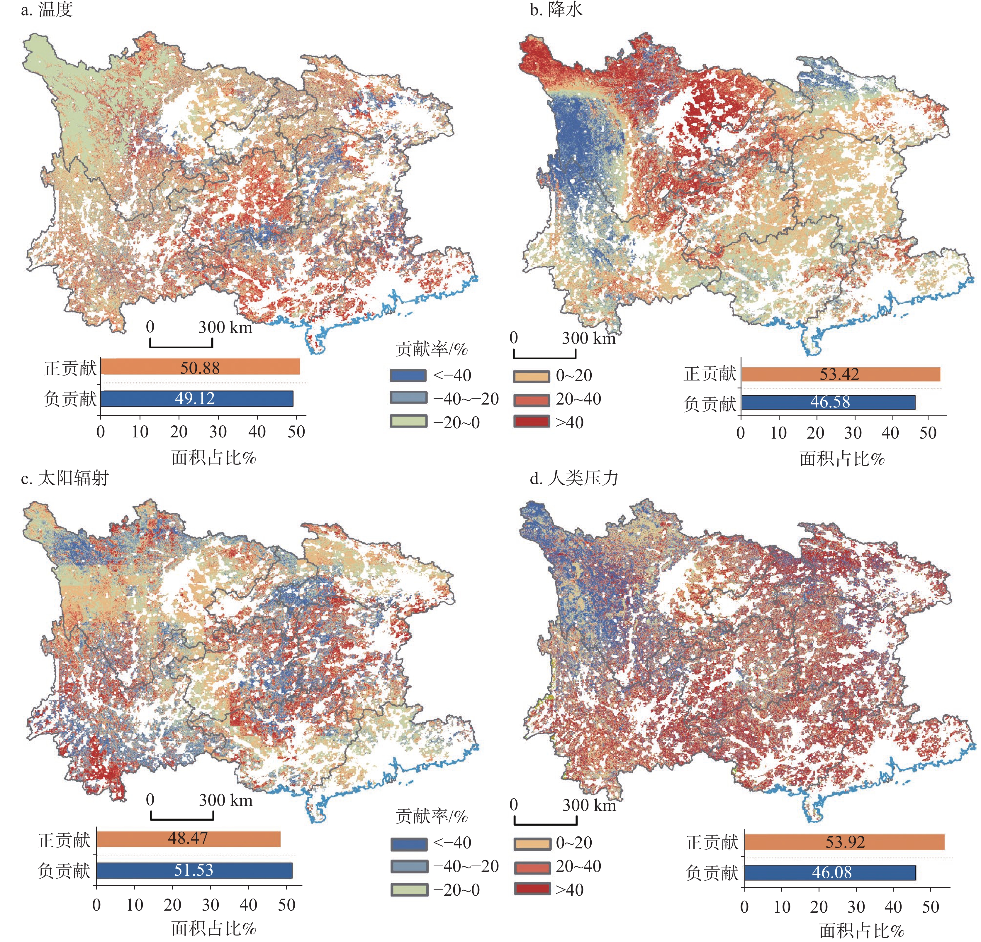
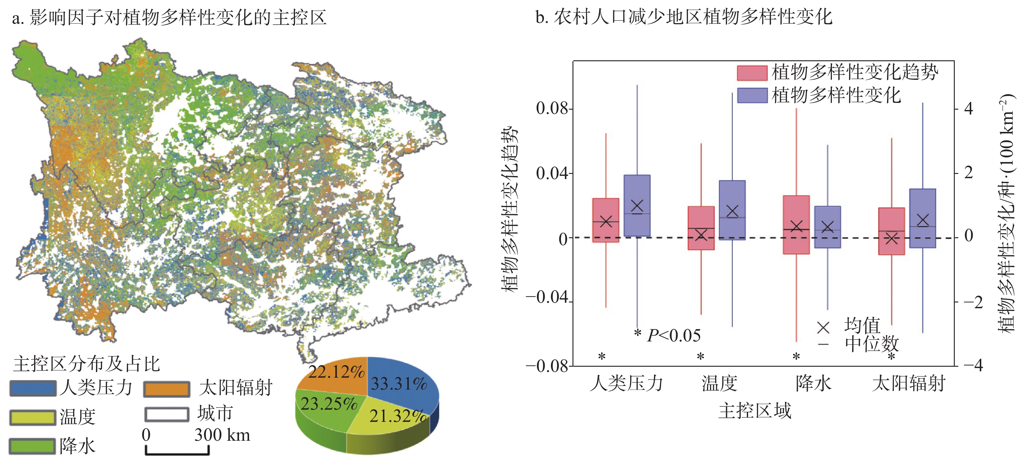
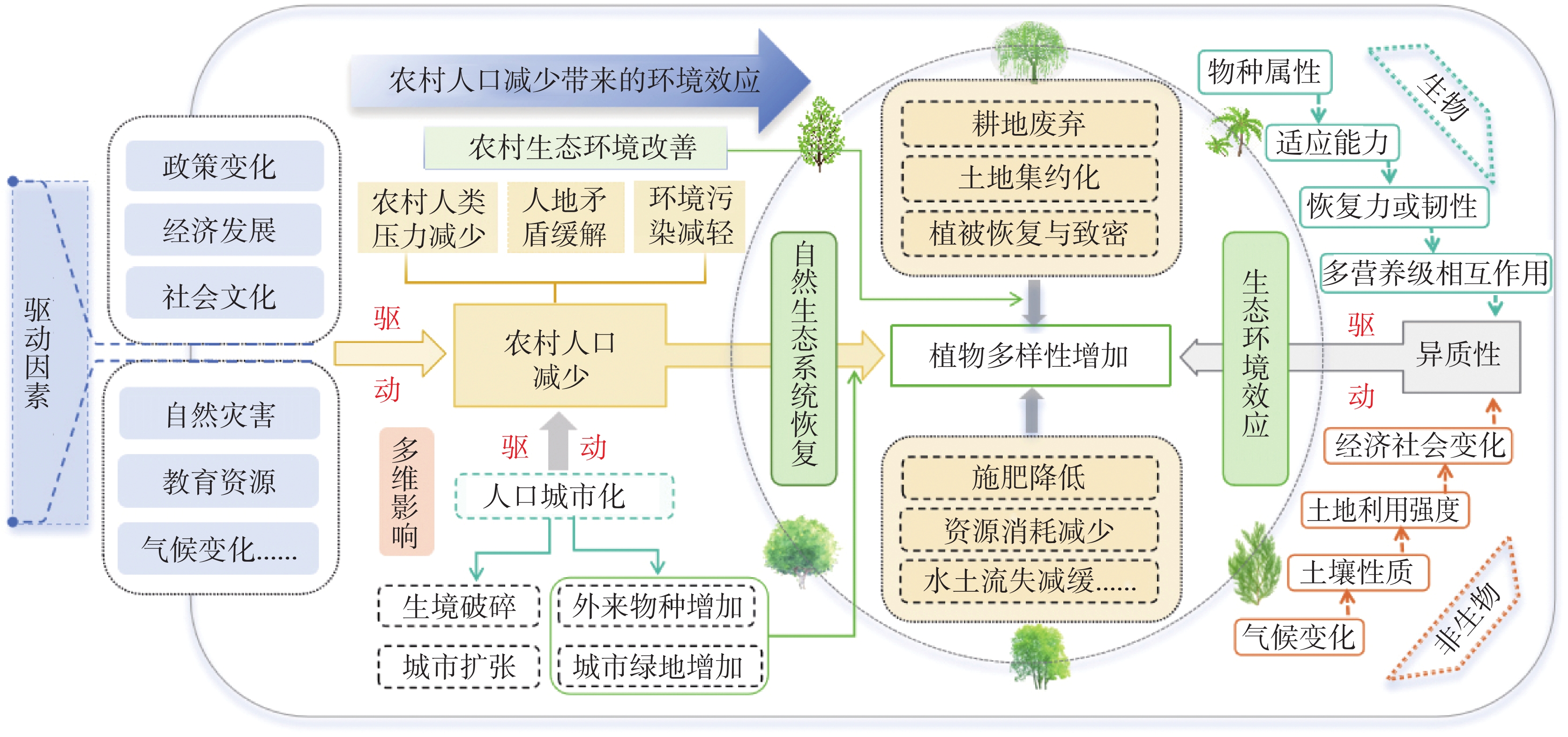
Although the global population continues to grow, the coming decades will witness the most rapid expansion of urban population in human history, primarily, driven by large-scale rural-to-urban migration. This migration alleviates human pressure significantly in rural areas, promotes the transformation of land use patterns and ecosystem restoration, and profoundly reshapes regional land spatial configurations. These changes directly or indirectly affect local ecological environments, thereby presenting both new opportunities and challenges for biodiversity. The southwestern region of China serves as a critical ecological security barrier for the country. It is not only a key area for global vegetation greening and plant diversity conservation, but also a typical region experiencing marked rural-urban migration and a pronounced decline in rural population. The ongoing and accelerating outflow of rural population in this region is profoundly reshaping local human-land relationships. Moreover, its distinctive karst landforms and ecological fragility make it highly sensitive to human disturbances. While large-scale rural population decline is reshaping the ecological environment, it also creates opportunities for ecosystem restoration. However, the response mechanisms of plant diversity to rural population decline and its threshold effects remain unclear, which hinders a deeper understanding of the coupling mechanisms in human-earth systems and constrains the scientific rigor and effectiveness of regional ecological conservation strategies.This study focuses on southwestern China as the research area. Based on vascular plant species richness data, the spatial pattern of plant diversity from 2000 to 2020 was reconstructed using a Random Forest model. The K-means algorithm was employed to identify urban-rural boundaries, revealing the spatiotemporal evolution characteristics of the rural population and examining the impact of rural population decline on plant diversity and its threshold effects. Using the human footprint index to characterize human pressure, the relationship between the release of human pressure induced by rural population decrease and the increase in biodiversity was analyzed. Through relative contribution rate decomposition, the driving contributions of climate change and human pressure were quantified. The study addresses the following key questions: (1) Spatiotemporal patterns of population decline in southwestern rural China; (2) Impacts of population decline on the spatial distribution of plant diversity and underlying mechanisms; (3) Threshold responses of plant diversity to changes in population density; (4) Relative contributions of climate change and human pressure to plant diversity changes.The results indicate that between 2000 and 2020, southwestern China experienced a rural population decrease of approximately 137 million, a 5.23% reduction in human pressure, and a significant 44.32% increase in plant diversity. Over 60% of the areas with rural population loss showed significant increases in plant diversity, with an average increase of approximately 0.73 species per 100 km2, across an area of 266,600 km2, Further analysis revealed a nonlinear relationship between rural population density and plant diversity: when population density fell below 336.68 persons·km−2, population decline exerted a suppressive effect on plant diversity; within the range of 336.68 to 956.73 persons·km−2, this suppressive effect gradually weakened; and when density exceeded 956.73 persons·km−2, population decline transitioned to a positive facilitative effect. Decomposition of driving factors showed that changes in rural human pressure contributed 38.64% to plant diversity changes, while climatic factors accounted for 61.36%, indicating that climate change remains the dominant factor influencing regional plant diversity.This study quantifies and reveals for the first time the nonlinear relationship and key thresholds between rural population decline and plant diversity in southwest China. It systematically elucidates the response mechanisms of plant diversity to population decline and human pressure, and clarifies the relative contributions of human activities and climate change. By analyzing the response patterns of plant diversity to rural population outmigration and identifying critical thresholds of population density effects, this research provides a scientific basis for understanding the mechanisms by which rural-urban migration influences biodiversity. The findings offer important insights for biodiversity conservation and regional sustainable development in southwest China.
Soil-litterfall-leaf stoichiometric characteristics of different woodland types in the Lijiang River Basin
ZHU Jing, WANG Ruru, LIU Ding, WANG Tong, LIANG Jianhong
2026, 45(1): 81-97. doi: 10.11932/karst20260105
Abstract:
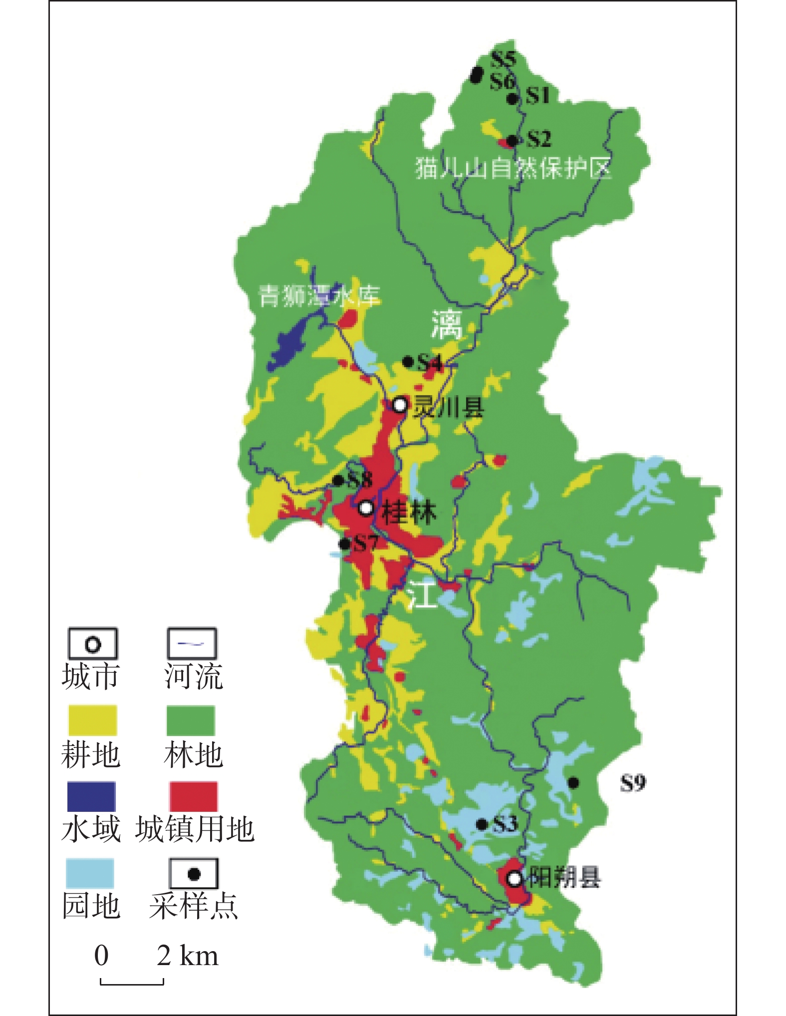
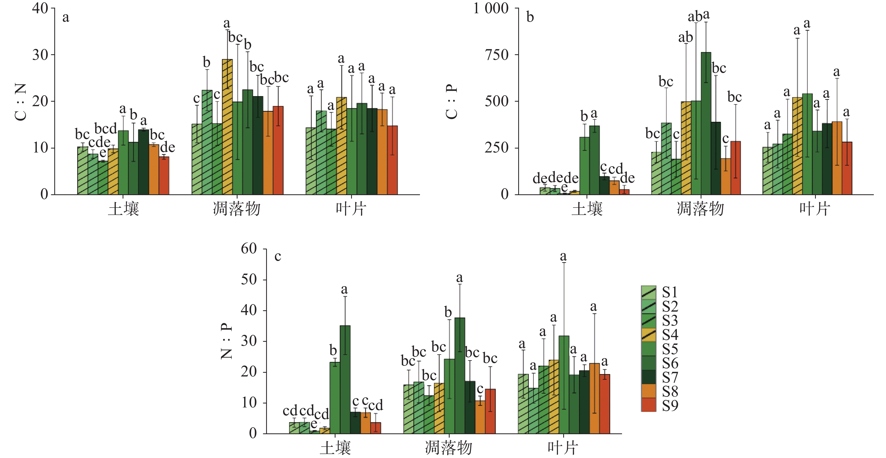
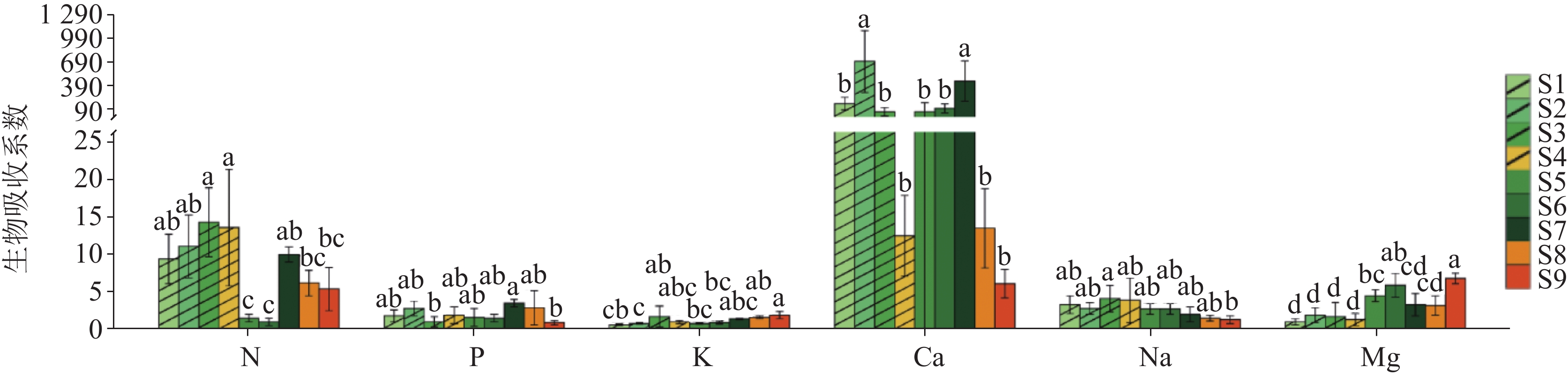
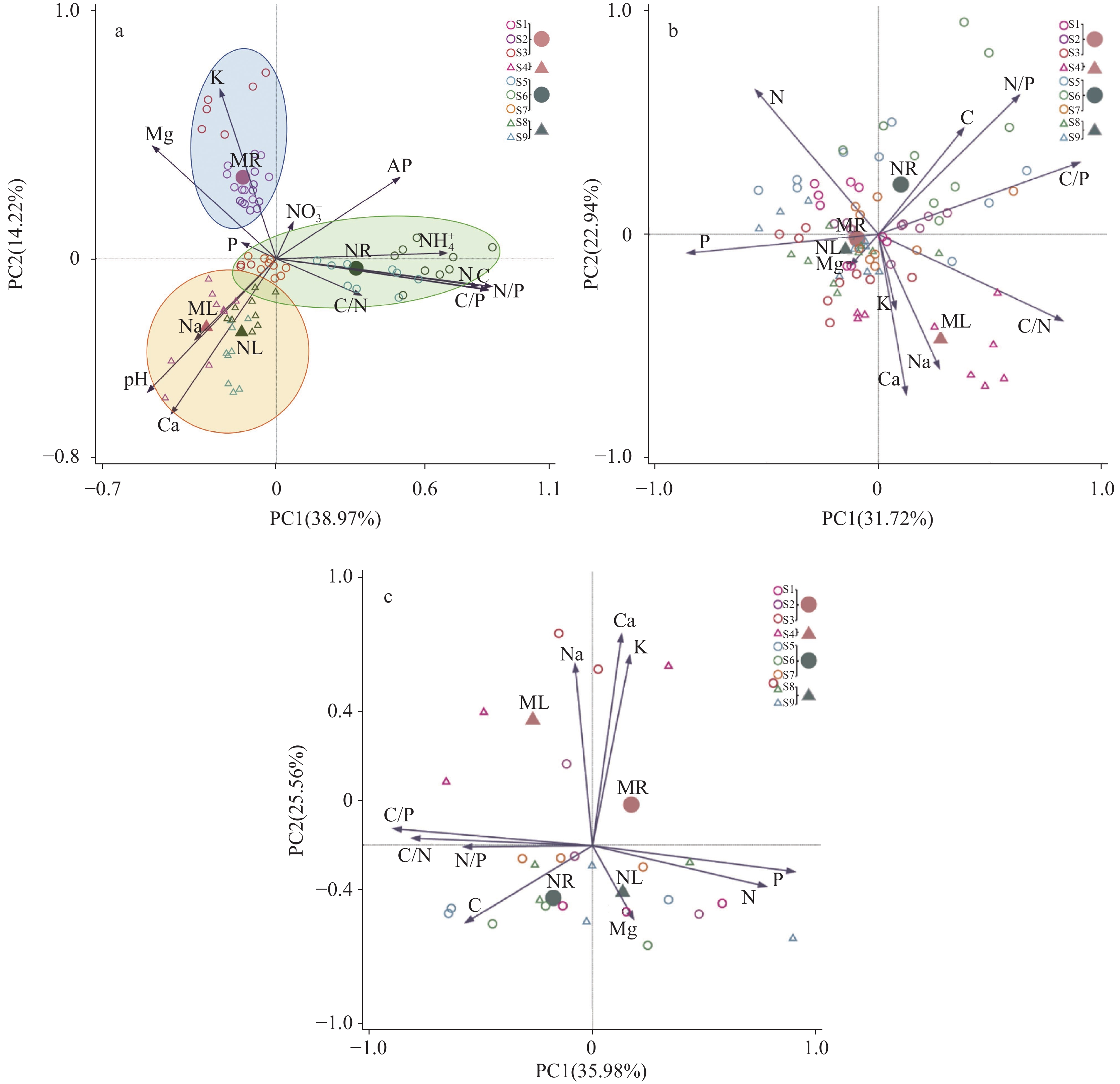
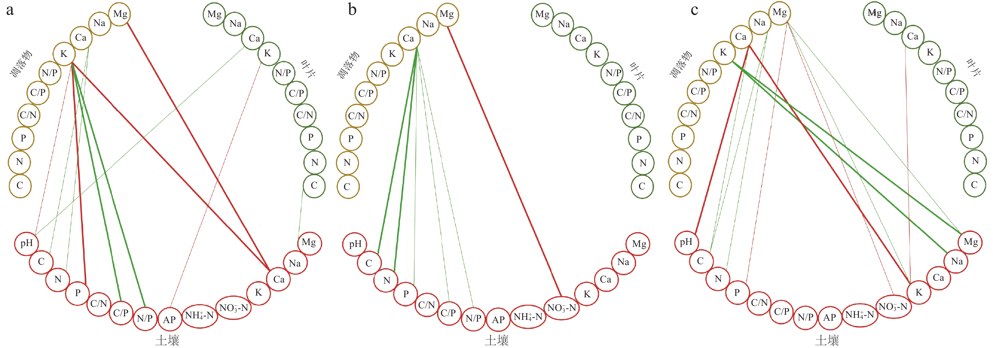
Ecological stoichiometry is a science that studies the interaction relationships of chemical elements in ecological components. By studying the nutrient element content and ecological indicator ratios in the "soil-litter-leaf" system, this study aims to analyze the correlation between nutrient elements and reveal the nutrient status of ecosystems, as well as the coupling process, balance mechanisms, and their impact on plant community structure and function.The study area is located in the Lijiang River Basin in Guilin, Guangxi. The basin has a subtropical humid monsoon climate and consists of a non-karst area upstream and a karst/non-karst mixture plain landform downstream. Nine representative sample plots were selected along the Lijiang River Basin, categorized into limestone soil (dominated by limestone/dolomite) and acidic red soil (derived from granite), with subgroups of natural forests (e.g., evergreen broad-leaved) and plantations (e.g., eucalyptus, bamboo). Soil, litterfall, and leaf samples were collected in autumn, spring, and summer of 2017 and 2018,respectively. The samples were analyzed for Total Organic Carbon (TOC), total nitrogen (N), total phosphorus (P), potassium (K), calcium (Ca), sodium (Na), and magnesium (Mg) as well as soil ammonium (NH$_4^{+}$), nitrate (${\rm{NO}}_3^{-}$) and Available P (AP). The biological absorption coefficient was calculated to reflect the ability of plants absorbing and accumulating chemical elements from the environment.The results showed that soil pH varied between 3.77 and 7.57, with significantly higher pH values in limestone soils compared to acidic red soils. There were no significant differences in soil C and N content between limestone and acidic red soils, but they varied significantly among different altitudes,showing low-altitude soils had lower C and N content compared to high-altitude soils,and plantations had lower soil C and N content compared to natural forests. Soil P content ranged from 0.39 g· kg−1 to 2.50 g· kg−1, with higher P content in acidic red soils compared to limestone soils. The C∶N ratio in soils was below 25, indicating nitrogen saturation and the risk for N leaching, especially for the limestone soil. High-altitude soils had higher C∶P and N∶P ratios compared to low-altitude soils. Litterfall element content and stoichiometric ratios showed smaller differences among different soils and forest types. Litterfall C and N content were slightly higher in natural forests compared to plantations. Litterfall P content ranged from 0.94 g·kg−1 to 2.62 g·kg−1. The average C/N of litterfall for limestone soil and acidic red soil were 20.0 and 17.8, respectively, consistently below the 25 threshold, indicating rapid decomposition. Leaves had the highest C, N, P and Ca content compared to soil and litterfall. The N∶P >16 in leaves (common in both forest types) suggested P limitation, particularly in forests under acidic red soil. Except for K, the biological absorption coefficient of leaves was above 1 and varied among different elements and forest types, with higher absorption coefficients observed in natural forests for K and Mg, lower for Na. The plants under acidic red soil had higher biological absorption coefficient for Ca compared to those under the limestone soil.Soil C, N, P, C∶P, and N∶P ratios, as well as litterfall K and Ca, played a central role in the element coupling relationship. Plantation and natural forests under limestone soil had similar soil element stoichiometric characteristics, mainly influenced by pH, Ca, and Na. Plantations under acidic red soil were mainly influenced by K and Mg, while natural forests were influenced by C, N, C∶P, and N∶P ratios.Soil elements had closer coupling relationships with litterfall elements compared to soil and leaf elements. In plantations under acidic red soil, P-related indicators (P, C/P, N/P and AP) and Ca played a key role in element coupling. Significant positive correlations were observed between litterfall K and soil pH, P, Ca, and between litterfall Mg and soil Ca. In natural forests under acidic red soil, litterfall Mg showed stronger coupling relationships with soil factors.This study revealed the soil-litter-leaf element stoichiometric characteristics and coupling relationships in different forest types in the Lijiang River Basin. The study identifies potential N loss and P limitation issues in the basin and suggests that integrating natural forest restoration could enhance ecosystem resilience by improving nutrient retention and reducing erosion risks. It provides scientific guidance for ecological conservation and restoration efforts.
Effects of soil conditioner dosage on soil physicochemical properties and maize growth in subtropical karst area
LIU Xiang, NING Jing, ZHANG Liankai, YANG Hui, LI Jie, SHI Yuanliang, Ewald Schnug, Silvia H Haneklaus
2026, 45(1): 98-111. doi: 10.11932/karst20260106
Abstract:
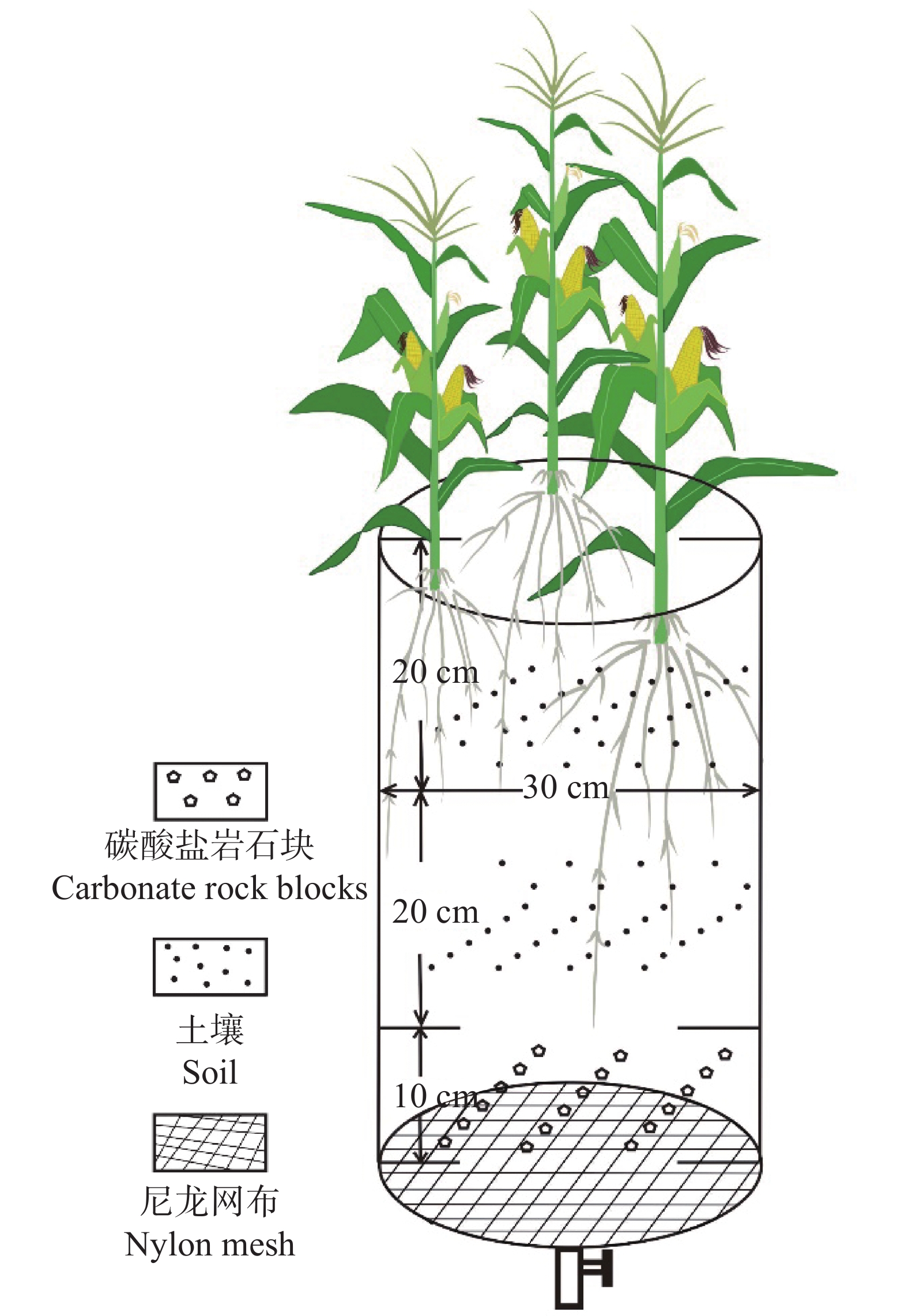
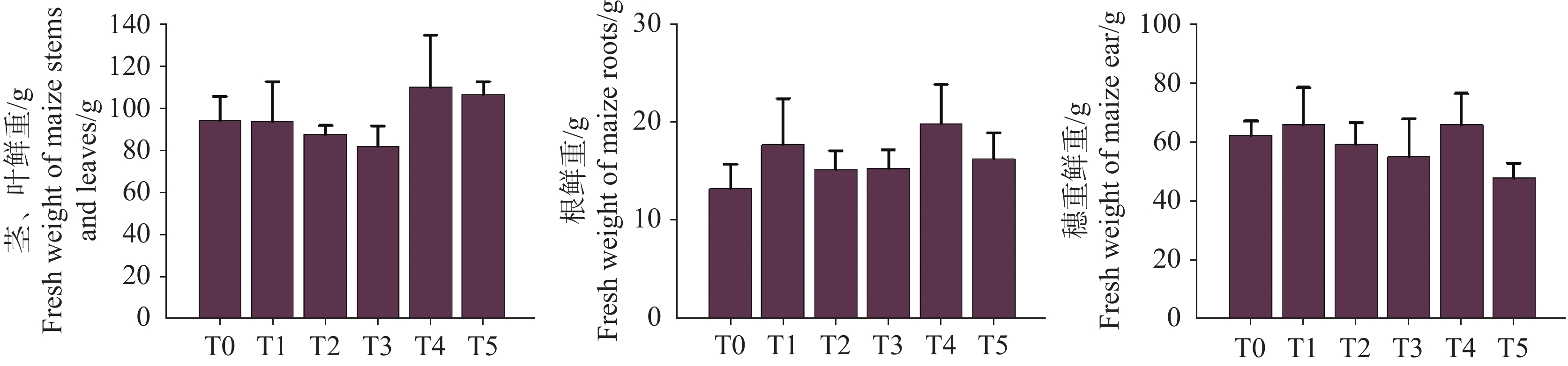
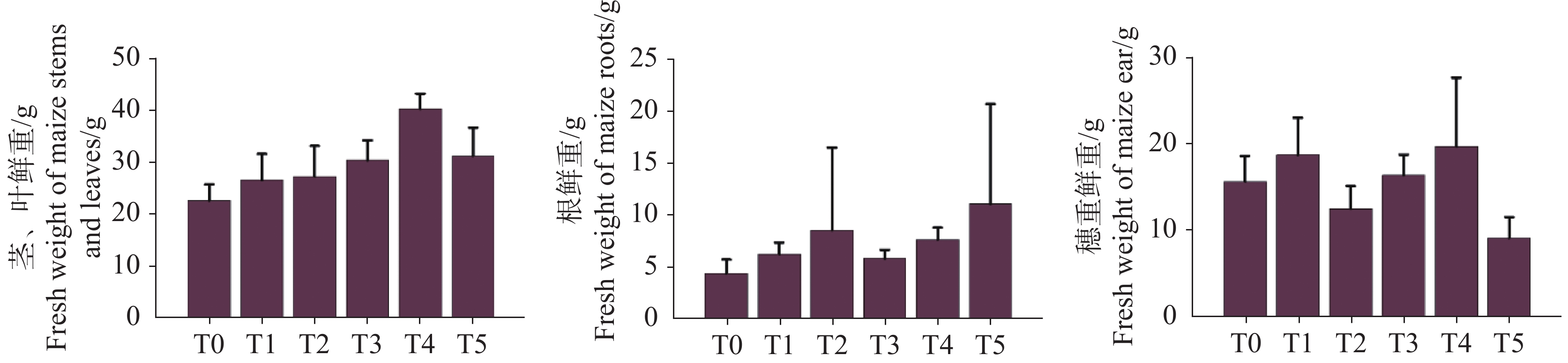
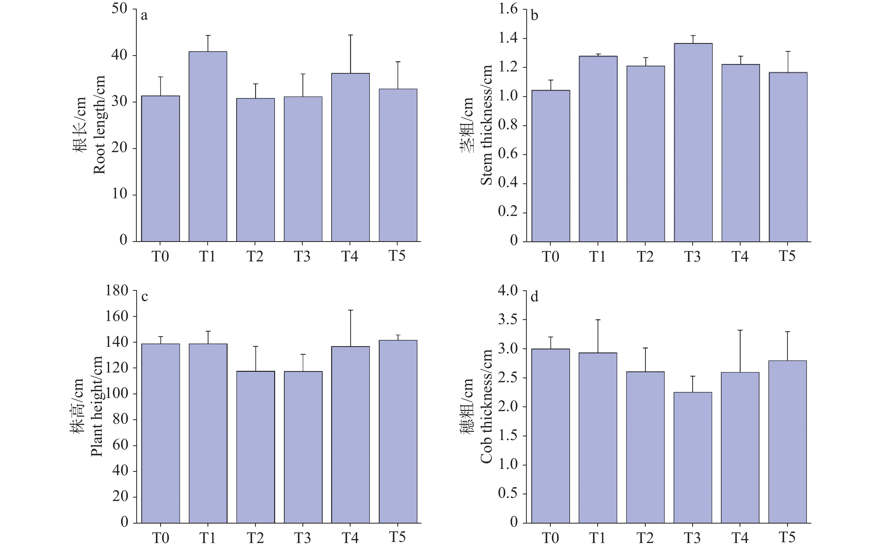
Soil resources in subtropical karst regions constitute a critical yet fragile component of agricultural arable land, playing a pivotal role in ensuring local food security and ecological stability. The unique geological setting dominated by carbonate rocks in these areas profoundly shapes the properties of the derived calcareous soils. A prominent challenge of such soils is their inherently heavy and sticky texture, stemming from high clay content and poor aggregation, which severely impedes water infiltration and root penetration. Concurrently, the region's high rainfall and porous bedrock accelerate nutrient leaching, exacerbating the soils' low water and fertilizer retention capacity,which leads to the frequent nutrient deficiencies, the obstruction of crop growth, and the decrease of agricultural productivity. Over time, these limitations have not only constrained yields of maize-a staple crop in many karst regions-but also exacerbated soil degradation and ecosystem vulnerability, highlighting the urgent need for effective soil improvement strategies. Against this backdrop, research on soil improvement technologies tailored to subtropical karst zones is essential for enhancing maize health, optimizing nutrient use efficiency, and providing actionable technical references for calcareous soil amelioration and balanced fertilization.To address this need, our study focused on developing a novel soil conditioner, specifically formulated to mitigate the constraints of karst calcareous soils. The conditioner was designed to improve soil structure, enhance nutrient retention, and promote nutrient availability, with the overarching goal of creating a more favorable growth environment for maize.To systematically evaluate the efficacy of the conditioner, we conducted controlled pot experiments involving combined applications of chemical fertilizers and varying concentrations of the conditioner. The experimental design included six treatments: T0 (control, no conditioner + 43 g per basin fertilizer) and T1-T5 (43 g per basin fertilizer combined with 1.35, 2.70, 4.05, 5.38, and 6.73 g per basin of the conditioner, respectively), with each treatment replicated three times to ensure result reliability. Over a 106-day growth period, we monitored soil physicochemical properties (pH, organic matter content, cation exchange capacity, and concentrations of macronutrients—N, P, K, S—and micronutrients—Ca, Mg, Fe, Cu, Zn, Mn, B, Mo, Cl) and maize biological traits (plant height, stem diameter, leaf area index, and aboveground biomass).A central component of our analytical framework was the integration of the Diagnosis and Recommendation Integrated System (DRIS), a robust method for assessing crop nutritional status by comparing nutrient ratios against optimal reference values. For mature maize leaves, we quantified 11 essential nutrients (N, P, K, S, Ca, Mg, Fe, Cu, Zn, Mn, B) and calculated DRIS indices to evaluate nutrient balance, identified limiting factors, and determined the Nutrient Imbalance Index (NII)—a composite metric reflecting overall nutritional status.The results revealed several key findings:(1) Regarding soil properties: in treatments T1-T5, concentrations of macronutrients such as N and P increased significantly with higher application rates of the conditioner (P<0.05), attributed to the conditioner's ability to inhibit nutrient leaching and promote mineralization. In contrast, concentrations of micronutrients including Ca, Cu, Mn, Cl, and Mo decreased with increasing conditioner dosage.(2) Concerning nutrient content in maize leaves: all T1-T5 treatments exhibited higher leaf nutrient concentrations compared to T0. (3) DRIS-based nutrient diagnosis indicated that the overall fertilizer requirement order for maize in karst regions was Fe>Cu>S>K>Ca>Mg>N>P>Zn>B>Mn,which has underscored the critical role of micronutrients such as Fe and Cu—often overlooked in conventional fertilization regimes—in limiting maize growth in these soils.Integrating soil nutrient data, leaf nutrient concentrations, DRIS indices, and NII values, the T4 treatment (5.38 g/basin HH conditioner + 43 g/basin fertilizer) was identified as the optimal combination. This treatment not only improved soil structure but also resulted in the lowest NII (1.23), indicating the most balanced nutritional status, and the highest maize biomass (38% higher than T0).In conclusion, the combined application of soil conditioner at optimal rates with chemical fertilizers effectively alleviates the constraints of karst calcareous soils, enhances nutrient availability, and promotes maize health. The DRIS-based approach provides a scientific basis for formulating tailored fertilization strategies in karst regions, contributing to sustainable agricultural development and soil conservation in these ecologically sensitive areas.
Hydrochemical characteristics and water quality assessment of Yepuqu alpine karst basin
LIAO Hongwei, HE Li, WANG Yu, WANG Yan, LIU Haiyong, PAN Xiaodong, HUANG Qibo, LI Tengfang, ZOU Changpei, REN Kun, MA Junfei, WU Huaying
2026, 45(1): 112-127. doi: 10.11932/karst2025y024
Abstract:
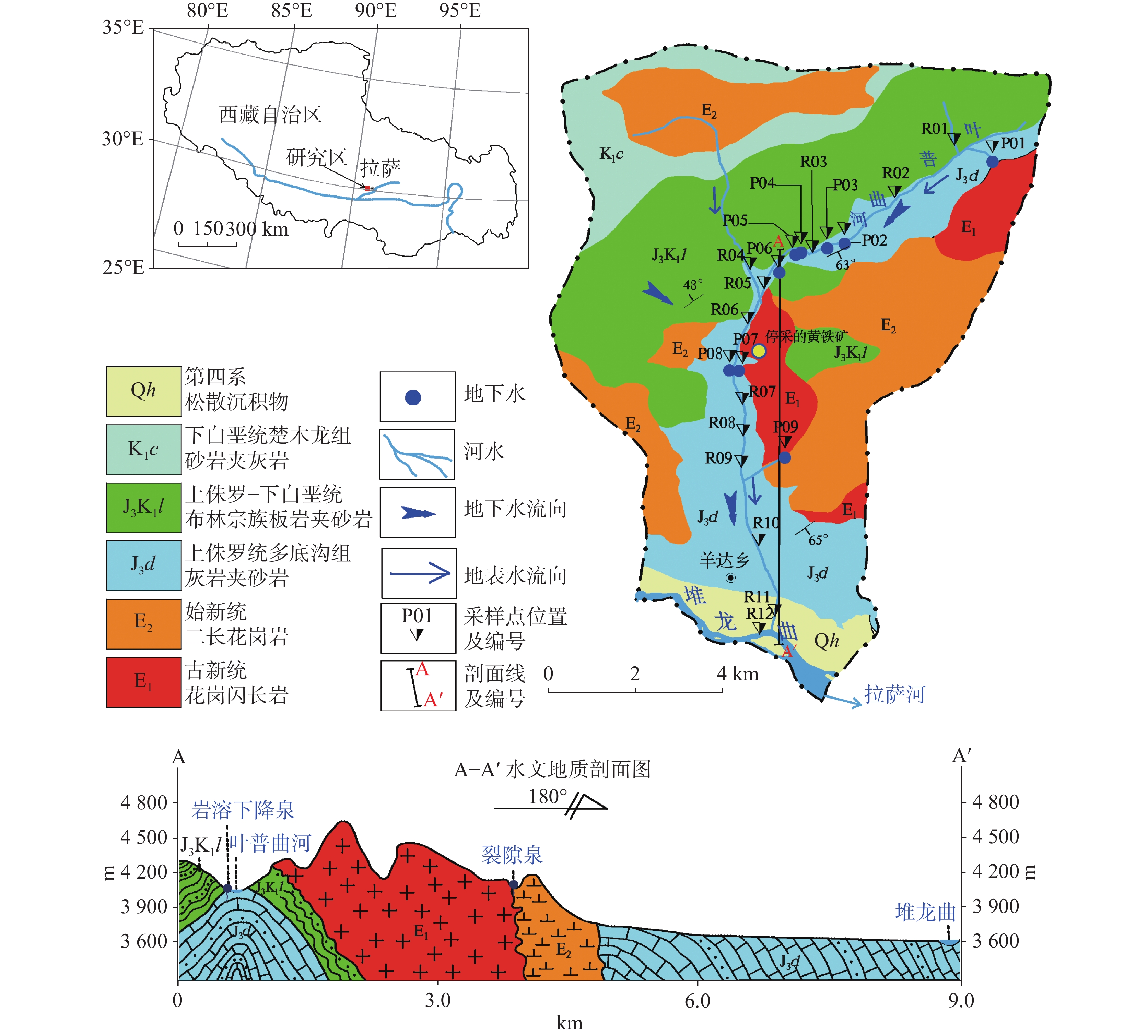
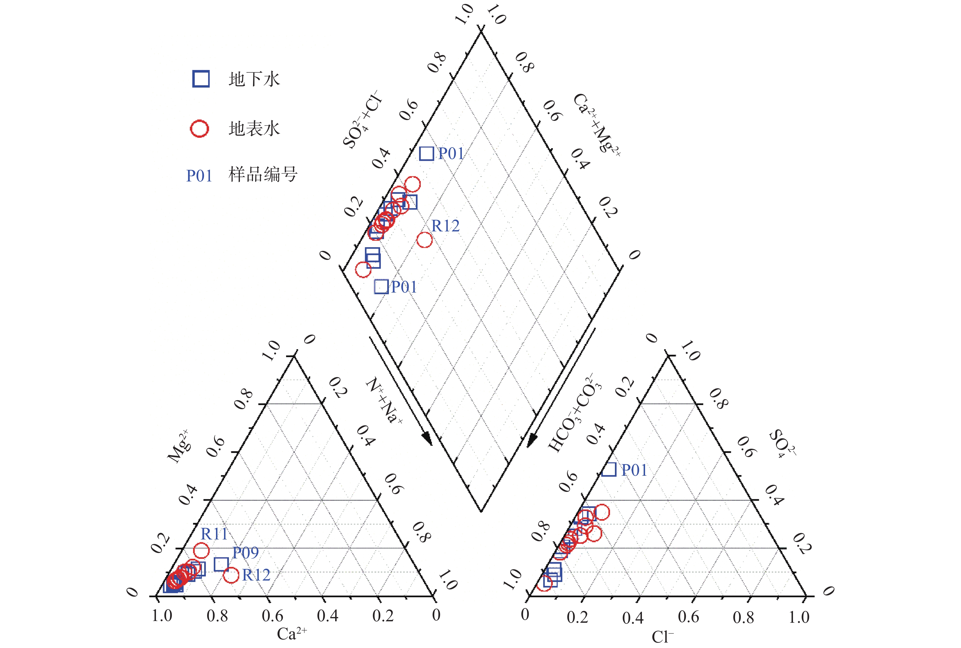
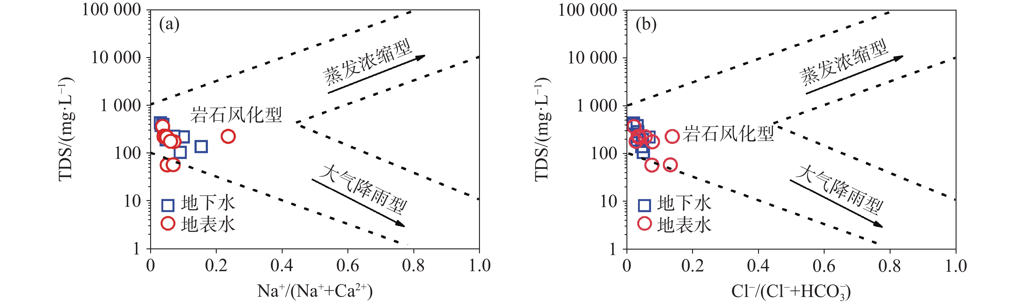
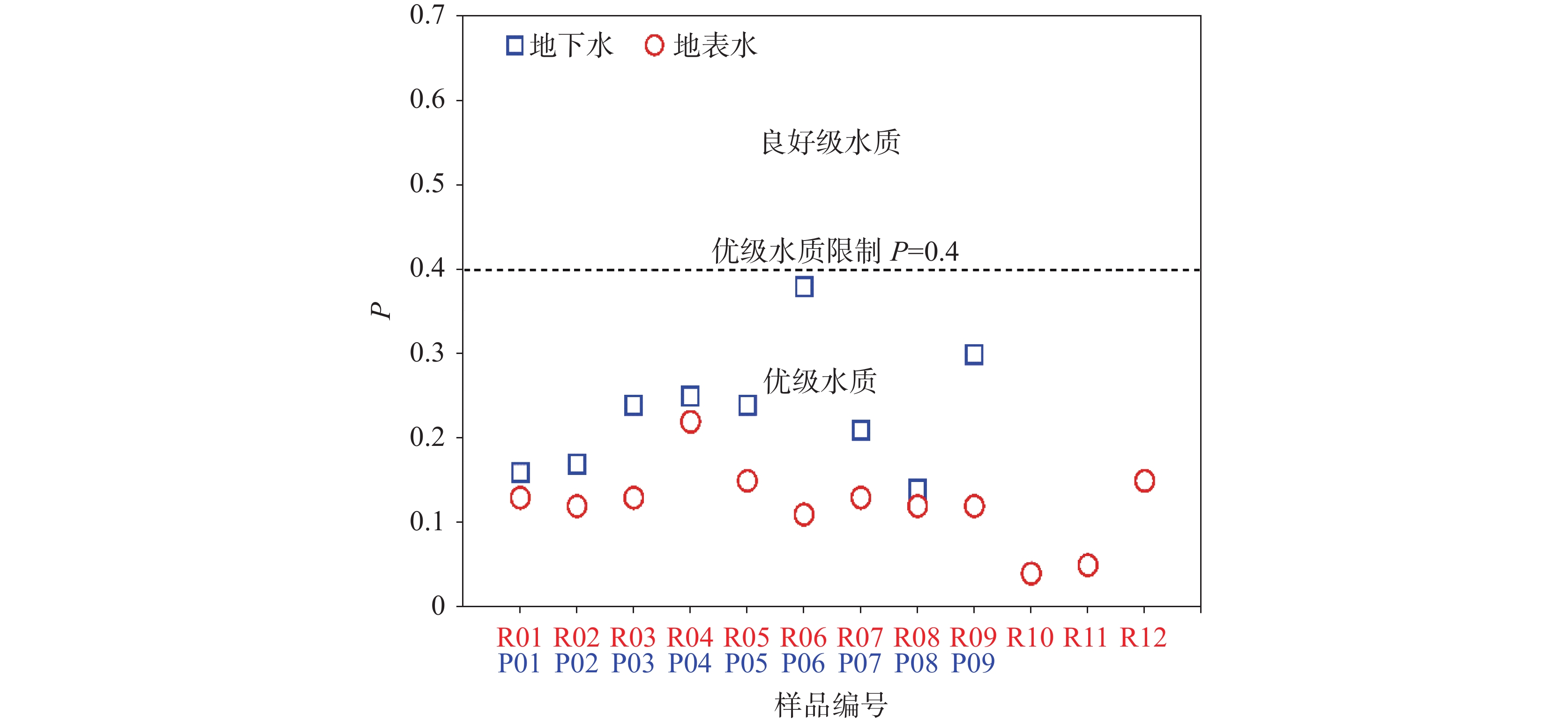
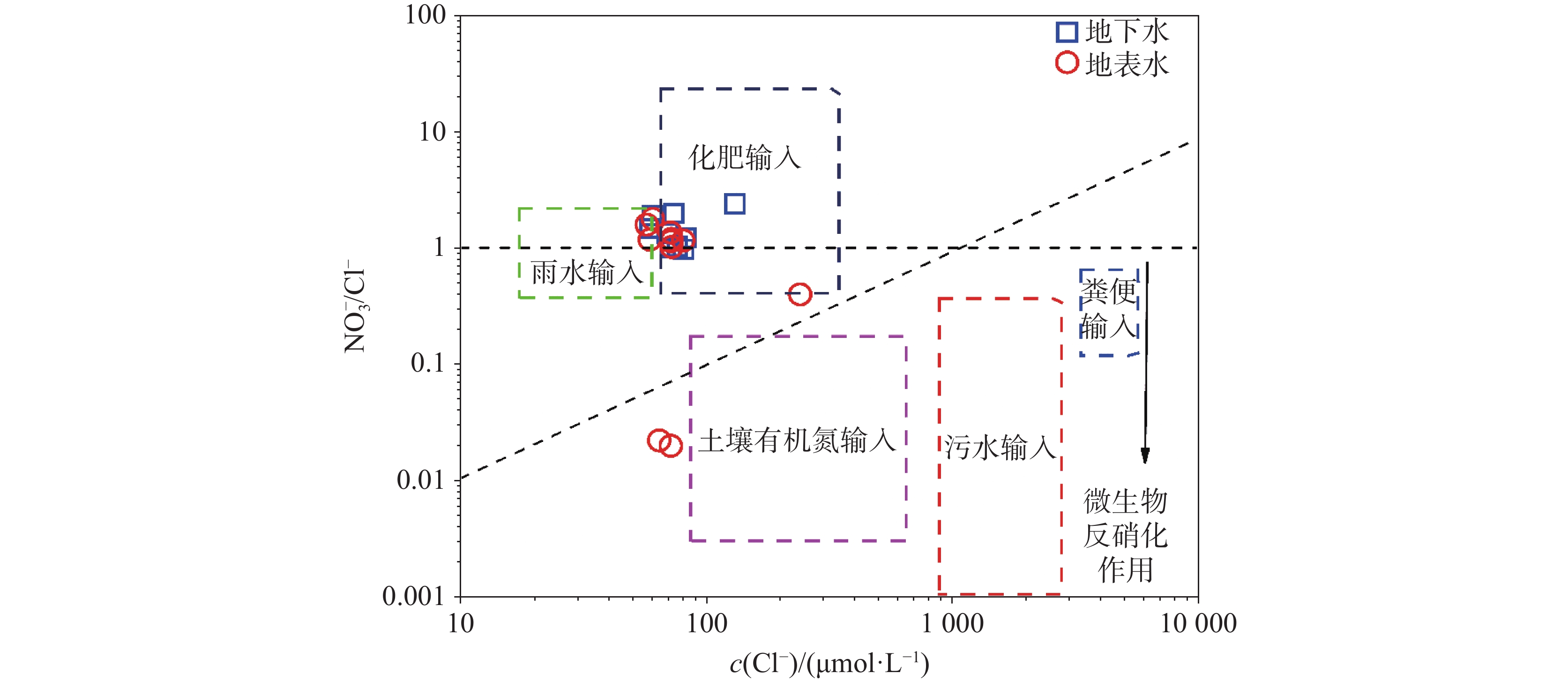
As a vital component of the "Asian Water Tower", the water quality of alpine karst water is one of the most critical environmental challenges for sustainable development on the Qinghai-Xizang Plateau. The Lhasa river basin, a core water source area in Xizang, plays a pivotal role in both the health of local residents and the ecological security of Asia's water systems. However, current research on karst water predominantly focuses on low-altitude regions, leaving significant gaps in understanding high-altitude karst systems. This study focuses on the Yepuqu karst basin, a tributary of the Lhasa river in northern Xizang, to investigate the hydrochemical characteristics and water quality of both surface water and groundwater. The research aims to reveal the hydrochemical composition and water quality features of a typical alpine karst basin, as well as the key controlling factors influencing the water quality.The systematic collection of surface water and groundwater in the Yepuqu karst basin was analyzed using methods such as hydrochemical analysis, principal component analysis, single-factor index, and comprehensive pollution index. The results indicated that the milliequivalent percentages of Ca2+ and ${\rm{HCO}}_3^{-}$ in the water bodies both exceeded 50% of their corresponding cations and anions, with the hydrochemical types of karst groundwater and surface water classified as HCO3-Ca and HCO3·SO4-Ca types, respectively. Ion balance diagram analysis showed that surface water was dominated by 83% calcite dissolution and 17% a combination of calcite and dolomite dissolution, while groundwater exhibited 67% calcite dissolution and 33% combined calcite-dolomite dissolution. The weathering and dissolution of rocks were the primary mechanisms controlling water mineralization, with both surface water and groundwater dominated by calcite dissolution, followed by combined dissolution of calcite and dolomite. Additionally, cation exchange reactions were also involved. The water quality analysis of the Yepuqu karst basin indicated that 86% of the 21 water samples evaluated by single-factor assessment belong to Class III, while 14% were Class IV and V. The comprehensive pollution index assessment further showed that the study area was of high-quality water. The results of two assessments showed certain discrepancies, primarily due to their differing assessment principles. Decision-makers can adopt a dual-track evaluation system combining "single-factor qualitative assessment + comprehensive pollution index quantitative assessment" to define different water quality conditions, thereby implementing more effective water resource management measures. This approach holds significant practical value for the comprehensive governance of water resources. Among them, Total Nitrogen (TN) was a key parameter in single-factor assessment, and the excessive nitrogen in water bodies primarily originates from fertilizer inputs. To address the issue of excessive TN levels in agricultural areas, an integrated prevention and control strategy of "source reduction,process interception,and smart monitoring" is recommended. This includes implementing crop rotation to reduce nitrogen fertilizer demand, applying soil testing-based formula fertilization with furrow-covering techniques to enhance nitrogen utilization efficiency, replacing chemical fertilizers with organic alternatives, and transforming drainage ditches into ecological filter beds to intercept nitrogen in runoff. Additionally, deploying soil moisture sensors for variable-rate fertilization can improve nitrogen agronomic efficiency. These measures collectively contribute to effective nitrogen management and water quality protection. The principal component analysis revealed that the primary factors influencing groundwater quality in the study area, ranked in order of significance, were anthropogenic activities, natural geological background values, and the composite effects of natural geological background and anthropogenic activities. For surface water quality, the key influencing factors followed the order of natural formation background values, anthropogenic activities, and the composite effects of natural geological background and anthropogenic activities. The results indicated that water quality in the study area was primarily influenced by three key factors: anthropogenic activities, natural formation background values, and the composite effects of natural geological background and anthropogenic activities. This study investigated the hydrochemical characteristics and water quality assessment of the Yepuqu alpine karst basin, which held significant theoretical and practical value for establishing a plateau water source protection system and safeguarding the ecological security of the "Asian Water Tower".
Study on the influence of hydrochemical characteristics on the genesis of intermittent high-temperature geysers in Xizang
LIU Gaoling, JIANG Zhenzhen, LI Yonglin, ZHUOMA Quxi, LI Mingli
2026, 45(1): 128-139. doi: 10.11932/karst20260107
Abstract:
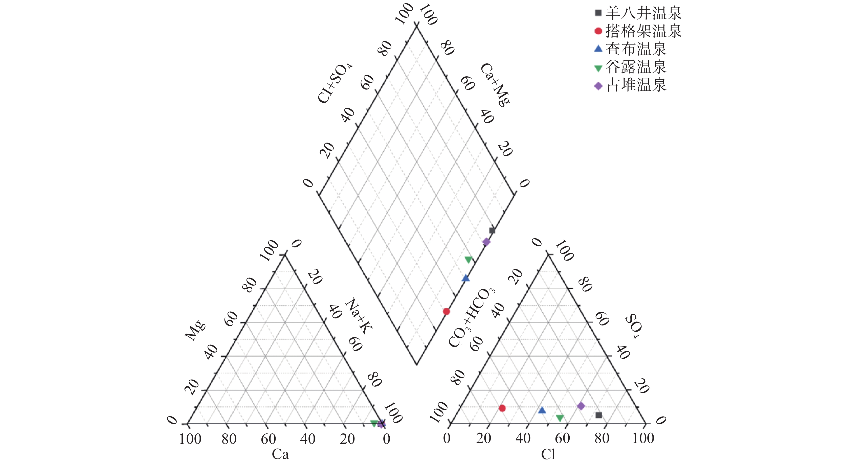
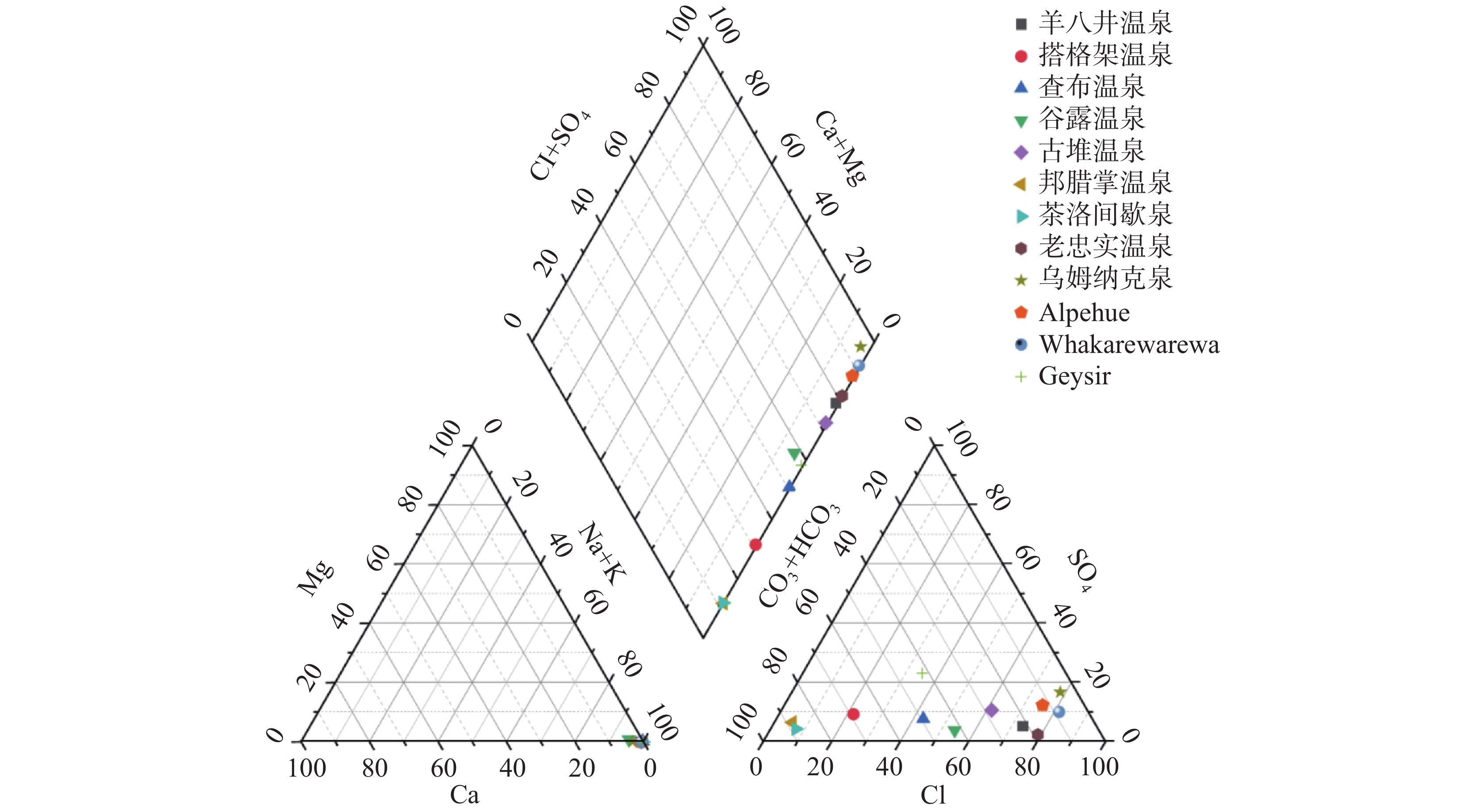
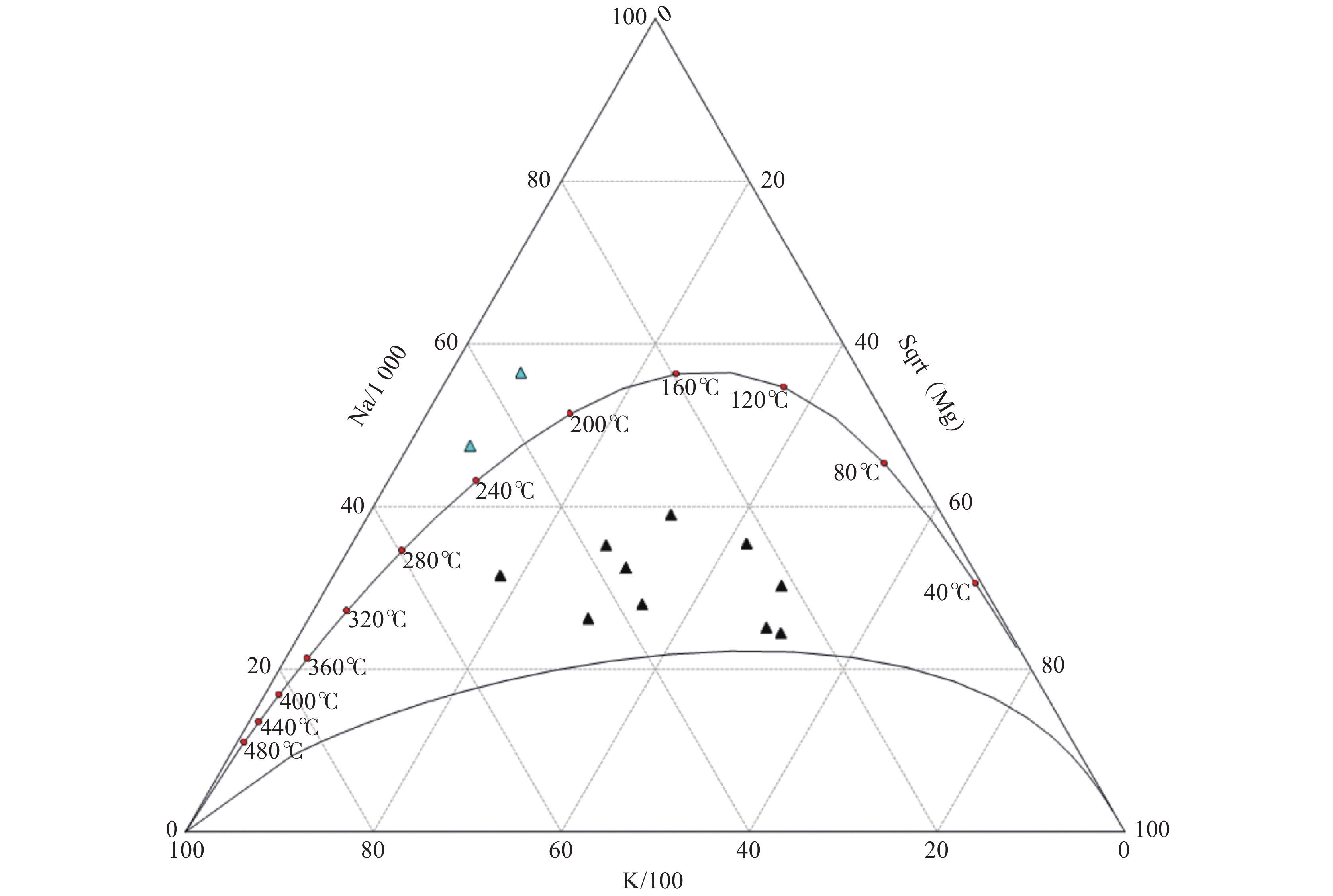
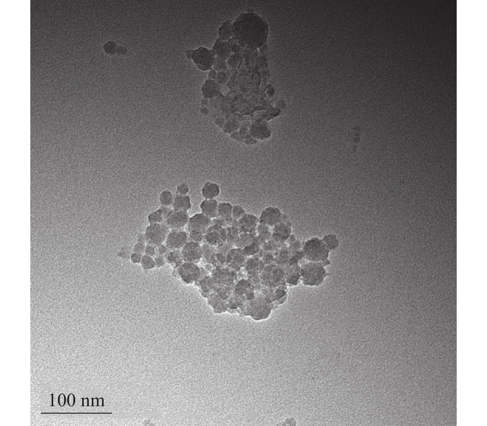
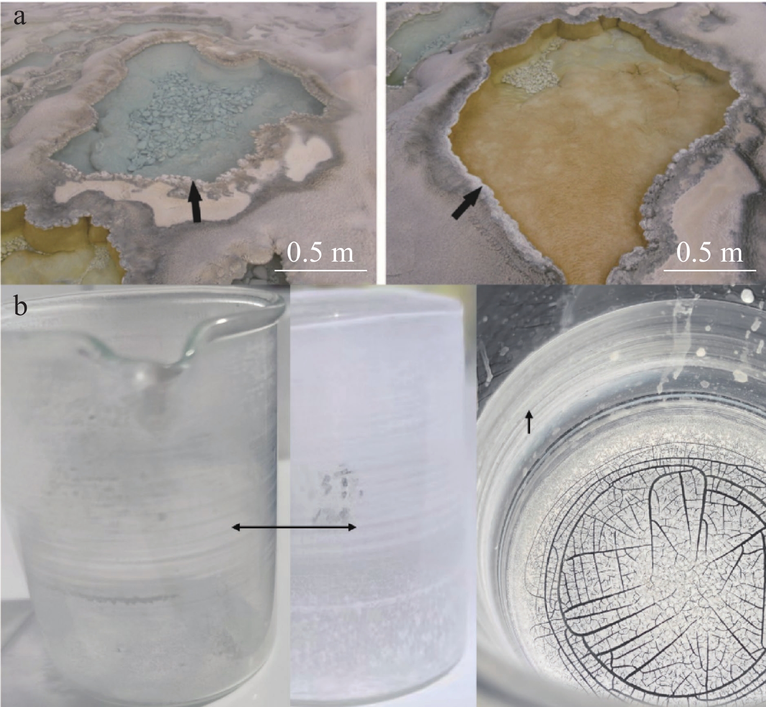
This study systematically summarizes the hydrochemical characteristics of typical intermittent high-temperature hot springs in Xizang, aiming to clarify the consistent patterns of their fluid composition and the key factors controlling their eruption. Through comprehensive analysis of hydrochemical parameters and graphical classification methods, the results reveal the high degree of similarity in the hydrochemical properties of these hot springs. Specifically, the geothermal water temperature is close to the local boiling point, with weakly alkaline pH. The water exhibits relatively high silica (SiO2) content; cationically, it is dominated by sodium (Na+) and potassium (K+), while calcium (Ca2+) and magnesium (Mg2+) contents are extremely low. Anionically, chloride (Cl) and bicarbonate (${\rm{HCO}}_3^{-}$) are the primary components, with a low sulfate (${\rm{SO}}_4^{2-}$) content. Based on these consistent features, this type of geothermal fluid is formally defined as "high-silica alkaline hydrothermal fluid". Focusing on the main chemical components of the fluid in intermittent high-temperature fountains, this study particularly emphasizes the presence of colloidal silica particles in the hydrothermal fluid and their intrinsic correlation with the formation of silicified films.In terms of hydrochemical composition, the intermittent high-temperature fountains exhibit distinct regularity and uniqueness, which are prominently reflected in their ionic distribution and environmental parameters. From the perspective of cation composition, Na+ and K+ are the dominant species, with their combined proportion accounting for up to 98% of the total cations-establishing them as the absolute main cations. In stark contrast, the proportions of Ca2+ and Mg2+, which are common cations in most geothermal systems, are negligible, typically less than 1%. This significant discrepancy in cation ratios constitutes one of the unique chemical signatures of these fountains. Beyond the aforementioned ionic characteristics, the high SiO2 content and weakly alkaline environment are indispensable properties of the intermittent high-temperature fountains in Xizang.These key factors interact synergistically to shape the unique, iconic hydrochemical composition of Xizang's intermittent high-temperature fountains, i.e., the high-silica alkaline hydrothermal fluid system.To further verify the hydrochemical type and evolutionary stage of the fluid, two standard hydrogeochemical classification tools were employed. On the Piper trilinear diagram (a widely used tool for hydrochemical classification), the cations of this fluid type are concentrated in the Na++K+ corner, while the anions are distributed along the base of the diagram, far from the ${\rm{SO}}_4^{2-}$ axis, which is consistent with the low ${\rm{SO}}_4^{2-}$ content observed in the chemical analysis. On the Na-K-Mg ternary diagram (a critical tool for evaluating geothermal fluid maturity), among the water samples collected from 12 intermittent high-temperature fountains, 10 were classified as partially mature water and 2 as fully mature water; no immature water samples were detected. This result indicates that the geothermal fluid has undergone sufficient water-rock interaction in the subsurface and has not been significantly mixed with shallow, unreacted groundwater, further confirming the deep-origin nature of the fluid.Furthermore, researchers identified that the structure of the groundwater reservoir of intermittent high-temperature fountains is critical to their eruption. For the periodic eruption to occur, the reservoir must maintain excellent airtightness to prevent pressure leakage. This airtightness is primarily attributed to the deposition of the low-permeability coating on the inner surfaces of large fractures or cavities within the reservoir, and the formation of this coating is closely linked to the high SiO2 content in the geothermal water. During the sedimentation process of colloidal silica particles in the hydrothermal fluid, these particles effectively reduce the contents of Ca2+ and Mg2+-likely through adsorption and co-precipitation. In contrast, alkali metal ions (e.g., K+, Na+, Li+, Rb+) are less affected by this process and thus remain relatively enriched in the fluid. Additionally, the high SiO2 content in the hydrothermal fluid promotes the formation of silicified films on the inner surfaces of fluid-flow channels and cavities. These silicified films can repair small fractures generated in the groundwater reservoir, thereby enhancing the reservoir's airtightness and providing effective pressure retention to support the subsequent eruption process.In conclusion, this study clarifies the unique hydrochemical characteristics of intermittent high-temperature hot springs in Xizang and defines the "high-silica alkaline hydrothermal fluid" type, which enriches the classification system of geothermal fluids in high-altitude regions. The analysis of the relationship between colloidal silica, silicified films, and groundwater reservoir airtightness also provides a new mechanistic understanding of the eruption of intermittent high-temperature fountains. These findings can serve as a theoretical basis for further research on geothermal systems in Xizang and other tectonically active, high-altitude areas, as well as for the exploration and utilization of geothermal resources in related regions.
Karst development characteristics and genesis model of Taiyuan formation in Huaibei mining area
LI Jun, GUI Herong, WAN Heyong, CHEN Zengbao, LI Weiqi, GUO Yan, XU Jiying
2026, 45(1): 140-151. doi: 10.11932/karst20260108
Abstract:
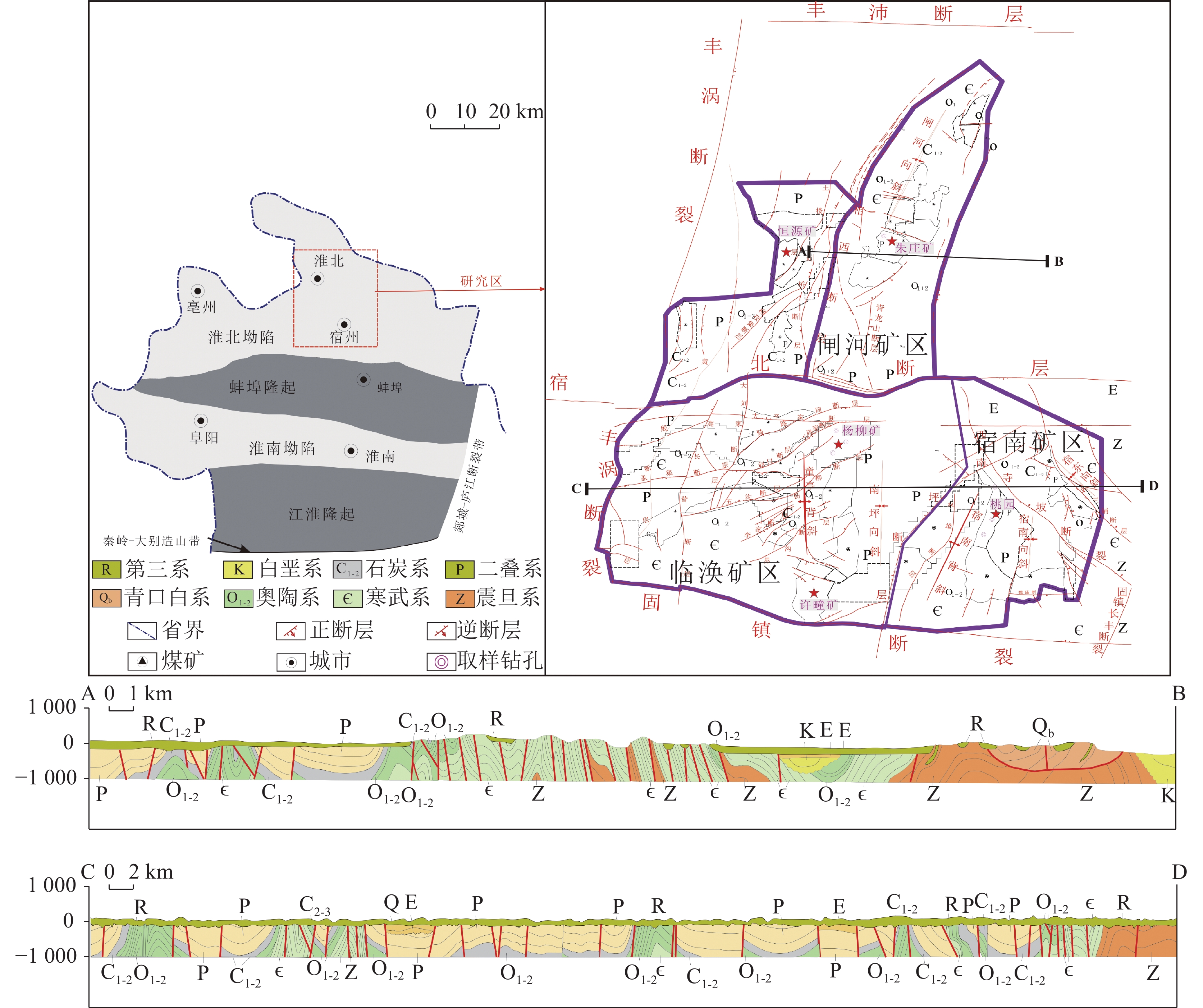
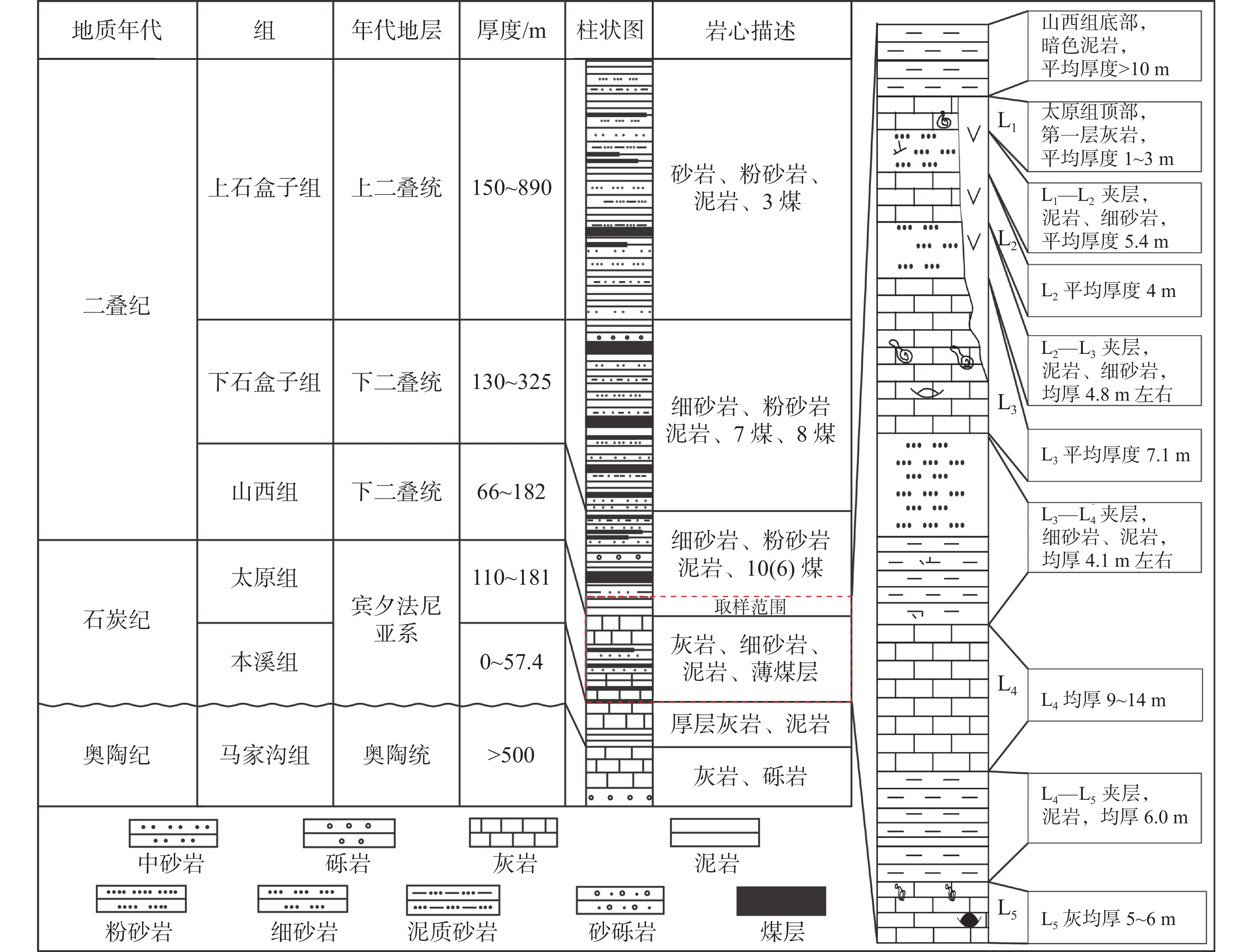
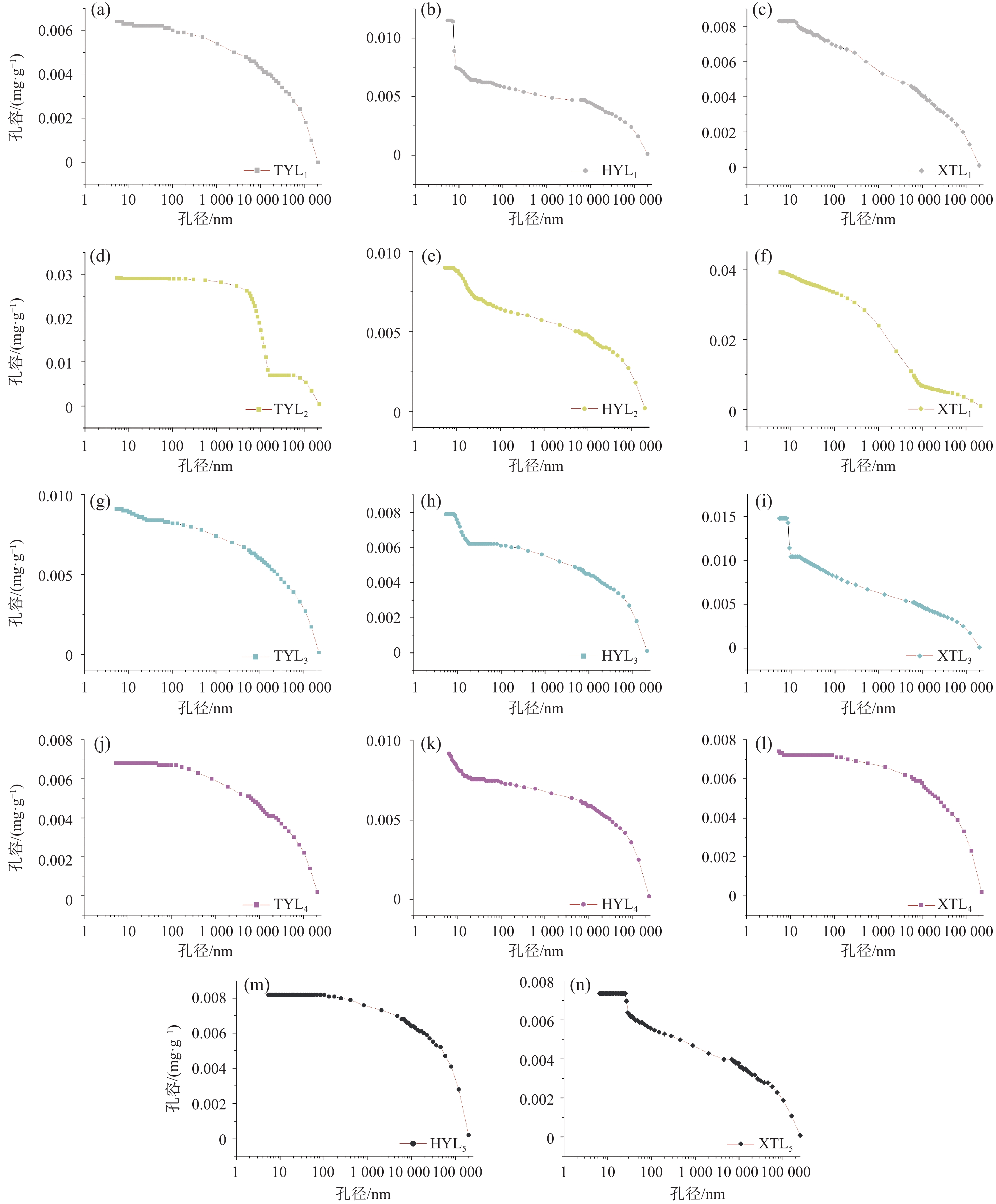
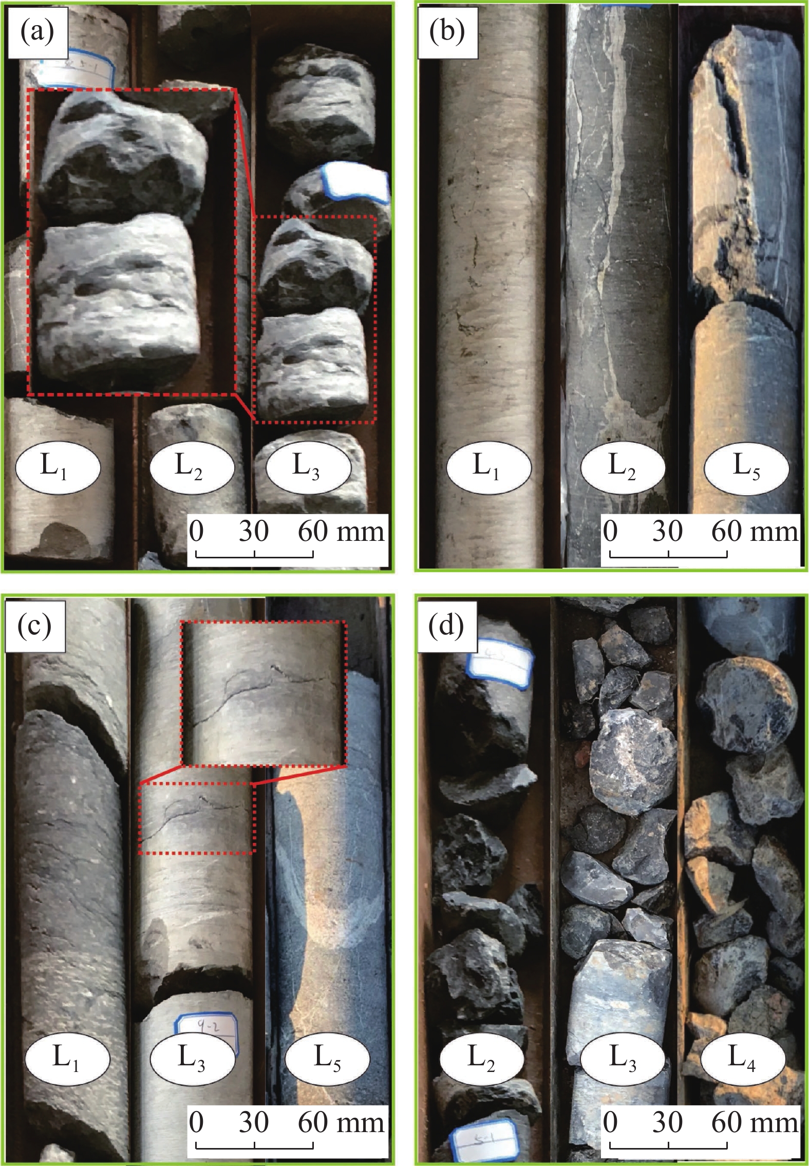
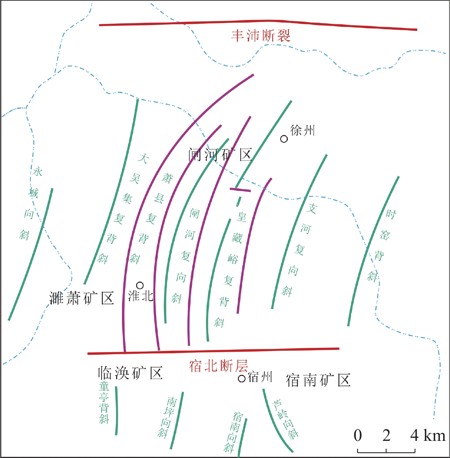
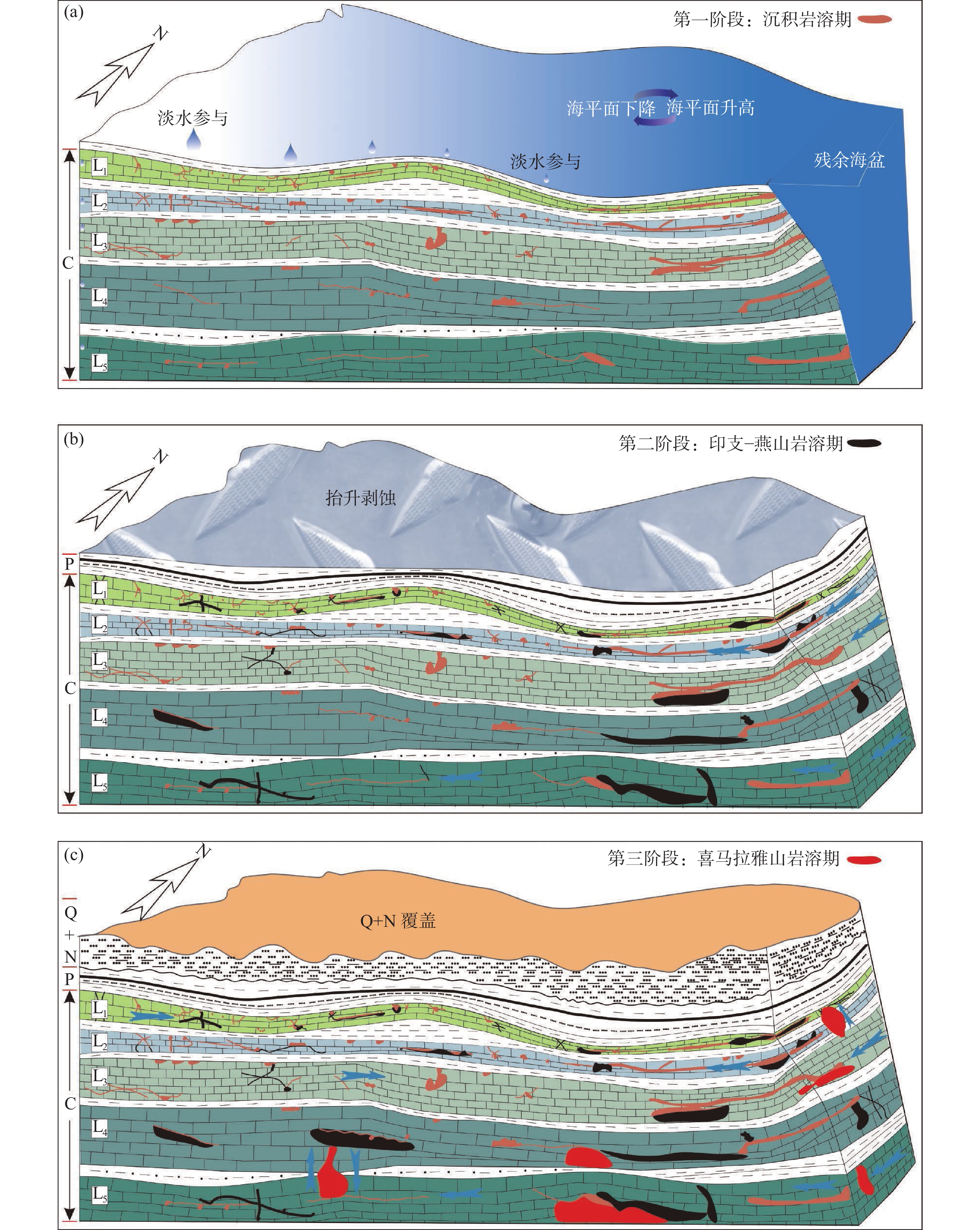
The exploitation of coal resources in the Huaibei mining area has provided crucial energy support for the industrial production and development of East China. The mining area is located on the southern margin of the North China Coalfield. The limestone of the Carboniferous Taiyuan Formation (referred to as "Taihui") occurs in the lower part of the Permian coal-bearing strata, characterized by "high water pressure and medium water abundance", and maintains a close hydraulic connection with the underlying Ordovician karst aquifer. With the gradual depletion of shallow resources, the threat posed by high-confined limestone water to mining safety under complex hydrogeological conditions in deep coal seams has become increasingly prominent. Historically, multiple "mine flooding" accidents occurred. To improve the technical system for preventing and controlling karst water hazards in the "North China-type" coalfields, this paper conducts a systematic investigation on the morphological structure characteristics and genetic evolution of karst features in the first to fifth limestone layers (L1—L5) of the Taihui. Methods such as hydrogeological tests and high-pressure mercury intrusion experiments were employed to systematically examine the distribution differences of karst pores, fractures, and cavities in both vertical and horizontal dimensions at macro- and micro- scales, and to evaluate the developmental characteristics of dissolved pores, cavities, and high- (low-) angle dissolved fractures.The results indicate that the Taihui in the northern Zhahe mining area is characterized by the development of karst fracture zones and cavities, whereas the southern Linhuan and southeastern Sunan mining areas are dominated by dissolved pores and fractures. Layers L1—L2 primarily contain mesopores and small-aperture macropores, while layers L3—L5, in addition to mesopores, also feature large-aperture macropores (approximately 100 μm). Based on an analysis of structural control over groundwater and strata, it was determined that the key reason for the vertical and horizontal differences in the karstification of L1—L5 in the Huaibei mining area is multi-phase tectonic movement. Horizontally, with the Subei Fault as the boundary, the northern mining area has undergone more intensive karstification. Vertically, the strongly karstified layers in the upper section of the Taiyuan Formation range from L3 to L5, which can serve as ideal target layers for regional grouting reinforcement and modification of the floor limestone. By integrating the regional tectonic evolution background and karst development characteristics, the transformative effects of regional tectonic evolution during various karst periods on the Taihui karst were discussed, and a genetic evolution model for the karst in L1—L5 of the Huaibei mining area was proposed: (1)Sedimentary Karst Period (302−295 Ma): During the deposition of L1—L5, frequent sea-level fluctuations occurred. At sedimentary hiatus interfaces, freshwater mixing and modification took place, leading to meteoric water leaching karst or interlayer karstification. Intergranular dissolved pores gradually expanded and interconnected, forming dissolved pores and interlayer dissolved fractures.(2)Indosinian-Yanshanian Karst Period (251−52 Ma): The high-angle and low-angle dissolved fractures formed in L1—L5 during this stage were stretched and further expanded by karst processes in the late Yanshanian period. The upper Taihui developed into a fracture network of considerable scale, marking the beginning of karstification differentiation on either side of the Subei Fault.(3) Himalayan Karst Period (52 Ma−present): The Huaibei mining area subsided into a new sedimentary depression phase, and L1—L5 underwent deep secondary burial karstification. The previously formed high- and low-angle dissolved fractures were filled with calcareous material after dissolution and expansion. The unfilled pores and fractures, along with the burial karst processes, developed into the observable karst pore-fracture-cavity system seen today.This study, through macro- and micro-scale investigations of the upper Taihui karst, has revealed the characteristics and genetic evolution model of pores, fractures, and cavities in the limestone of the study area. The main conclusions are as follows.(1) At the micro-scale, in the L1 limestone, the Sunan mining area exhibits the highest contribution from macropores with apertures <1 μm and mesopores, while other mining areas are dominated by mesopores with apertures <20 nm. In the L2 limestone, mesopores and macropores with apertures of 10 to 5,000 nm are the main pore types. In the L3 limestone, mesopores (<50 nm) dominate.(2) At the macro-scale, the L1 limestone across the Huaibei mining area is relatively intact, with rare fracture zones. In the Linhuan mining area, the L2 limestone develops fracture zones approximately 10 cm in length, with fracture surfaces mostly aligned parallel to the sedimentary bedding planes. In the Zhahe mining area, the L3 limestone exhibits fracture zones longer than 10 cm, with vertically developed fracture surfaces. The core is relatively fragmented, and fractures are often filled with calcareous material. In the Sunan mining area, the L4 limestone contains a fracture zone about 20 cm in length in its middle section.(3) The present-day karst characteristics in the Huaibei mining area represent the product of superimposed multi-phase tectonic movements. The activation of structures such as the Xusu arcuate thrust nappe and the Subei Fault has initiated erosive fluid circulation conditions, governing the horizontal and vertical paleo-karst differentiation within the mining area.(4) Four karst formation stages have been delineated: The Sedimentary Karst Period, Indosinian Period, Yanshanian Period, and Himalayan Period, which are divided into three developmental phases. The genetic evolution model of the upper Taihui karst in the Huaibei mining area comprises stages of primary porosity development, secondary modification, opening-closing of dissolution fractures, and differential burial.
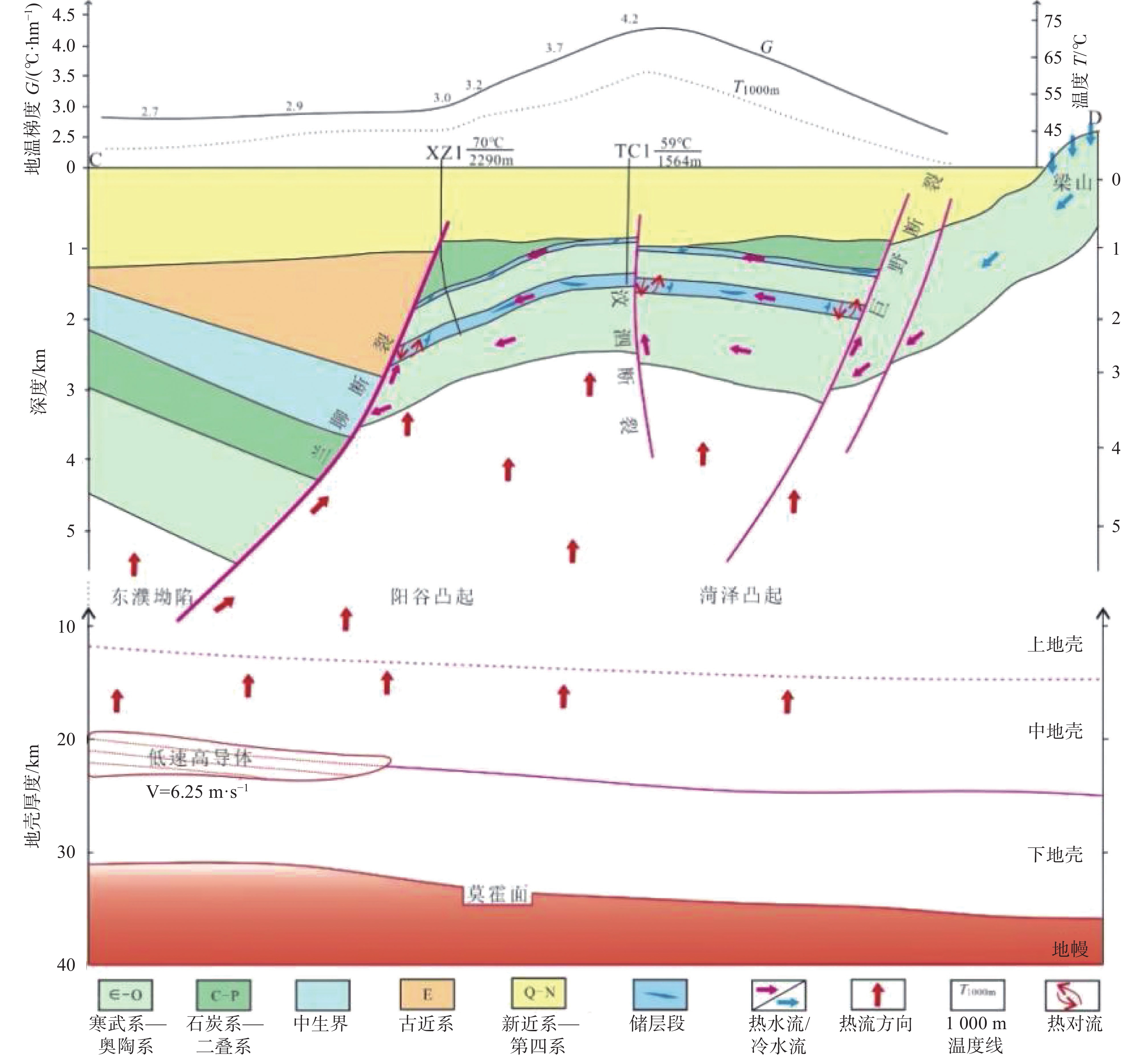
Genetic model of basin-margin fault-uplift geothermal field: Taking the southern section of the Yanggu Uplift as an example
ZHANG Hui, WANG Xinwei, QIAN Keran, MAO Xiang, LUO Lu, LIU Xiaohong, WANG Yuxing
2026, 45(1): 152-166, 192. doi: 10.11932/karst20260109
Abstract:
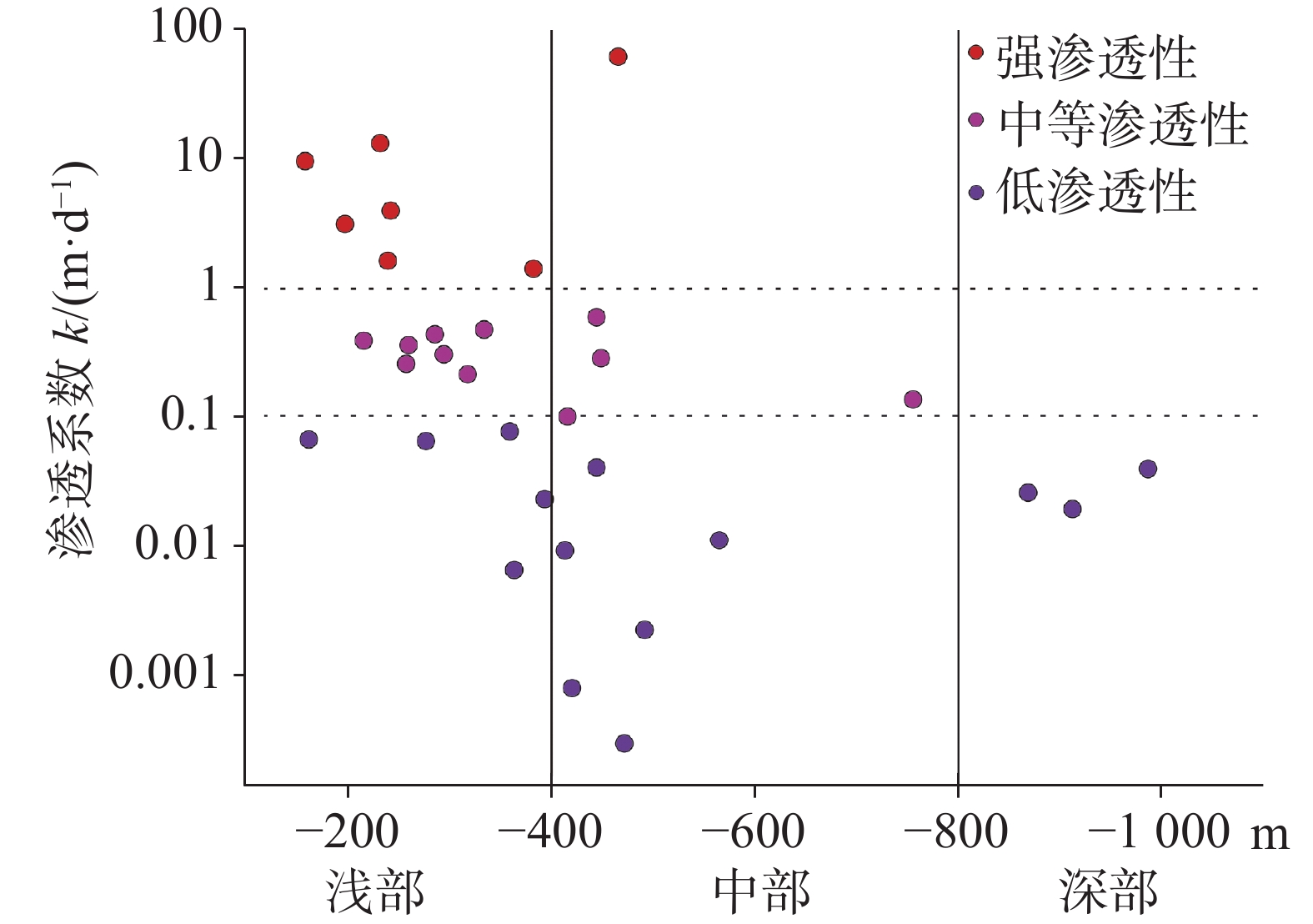
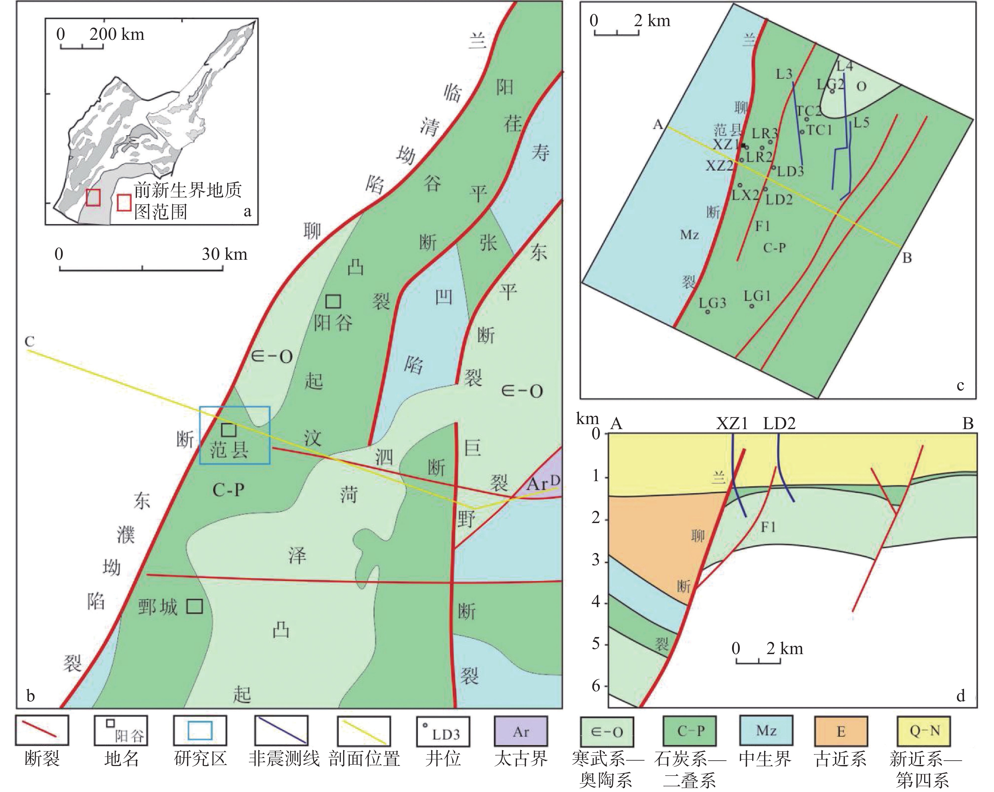
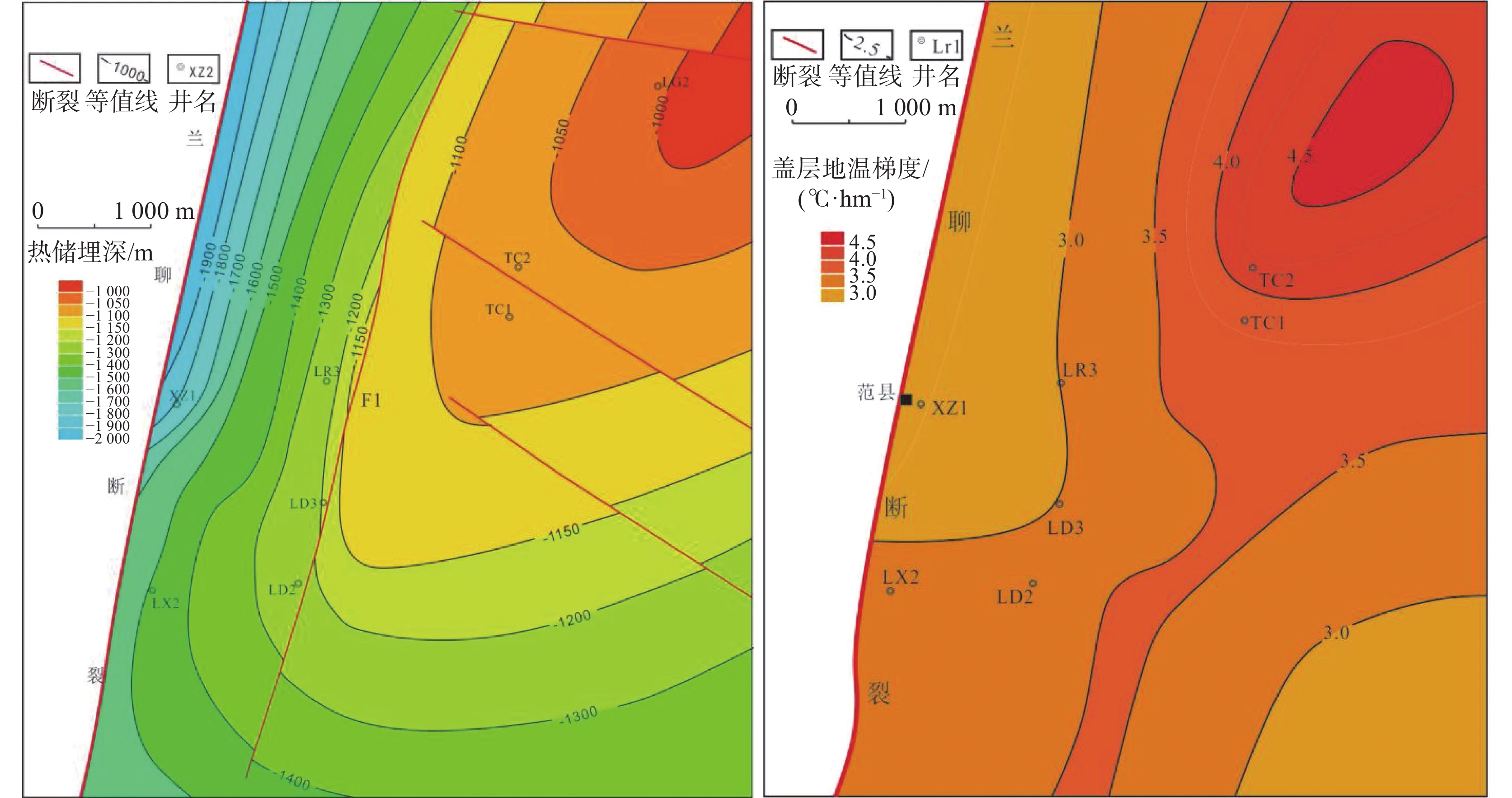
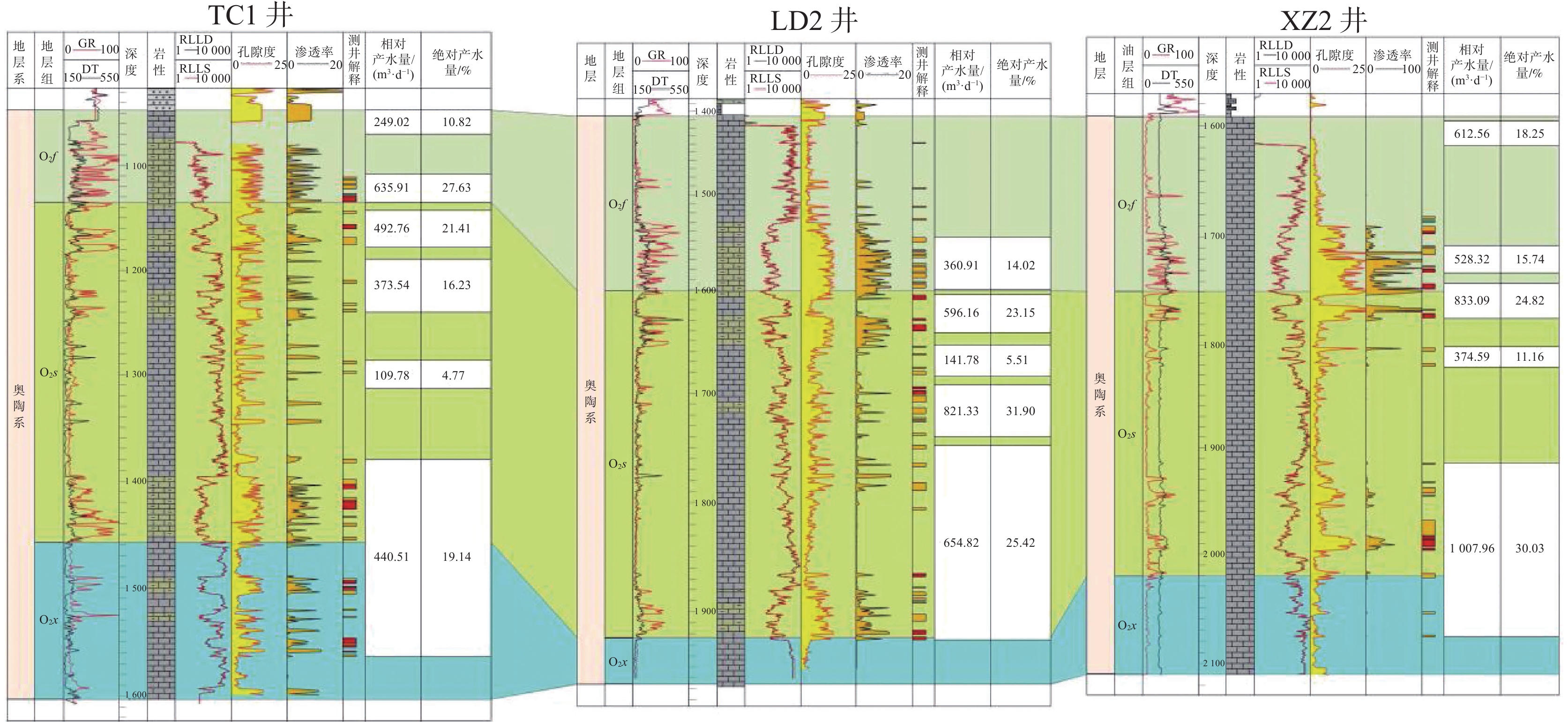
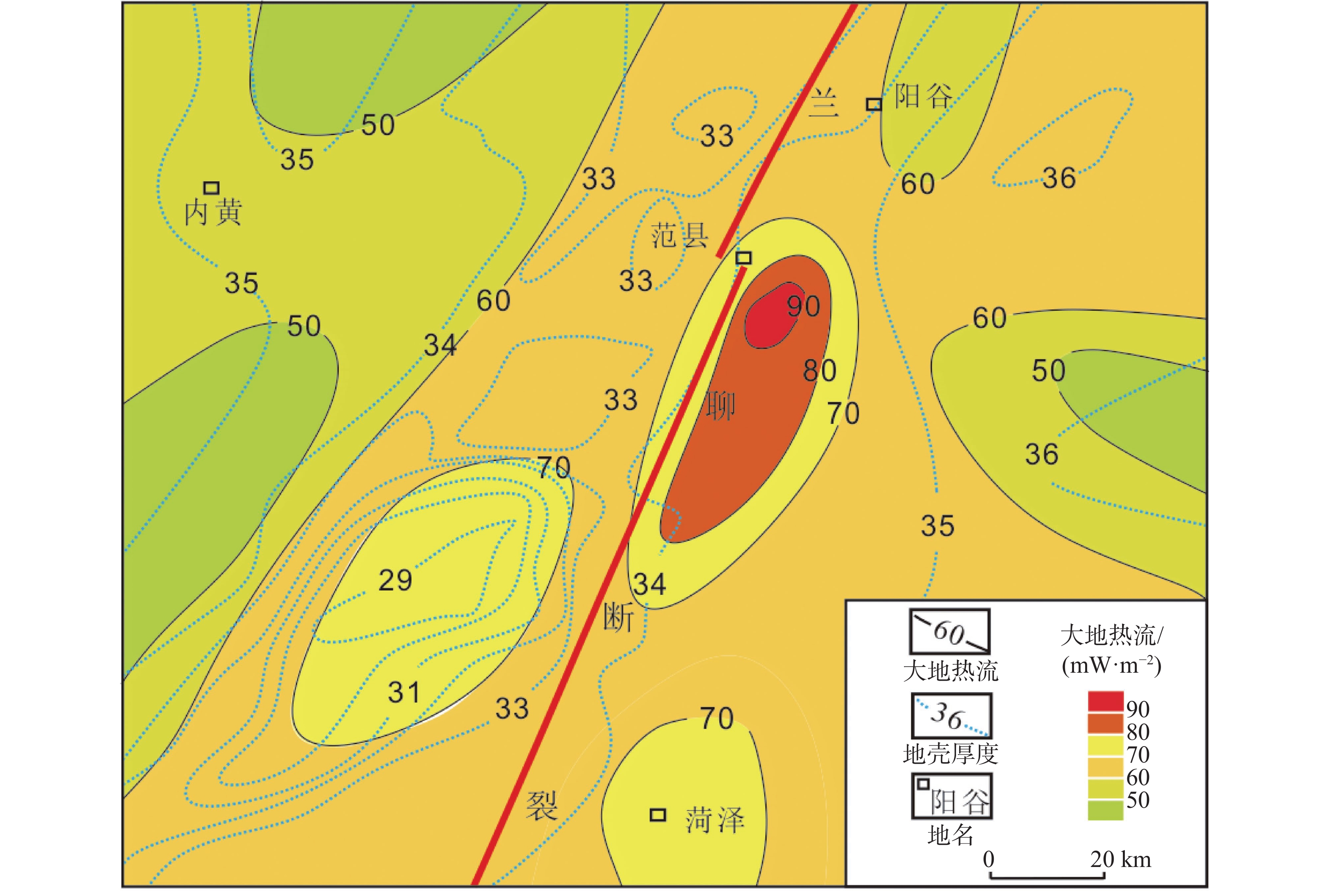
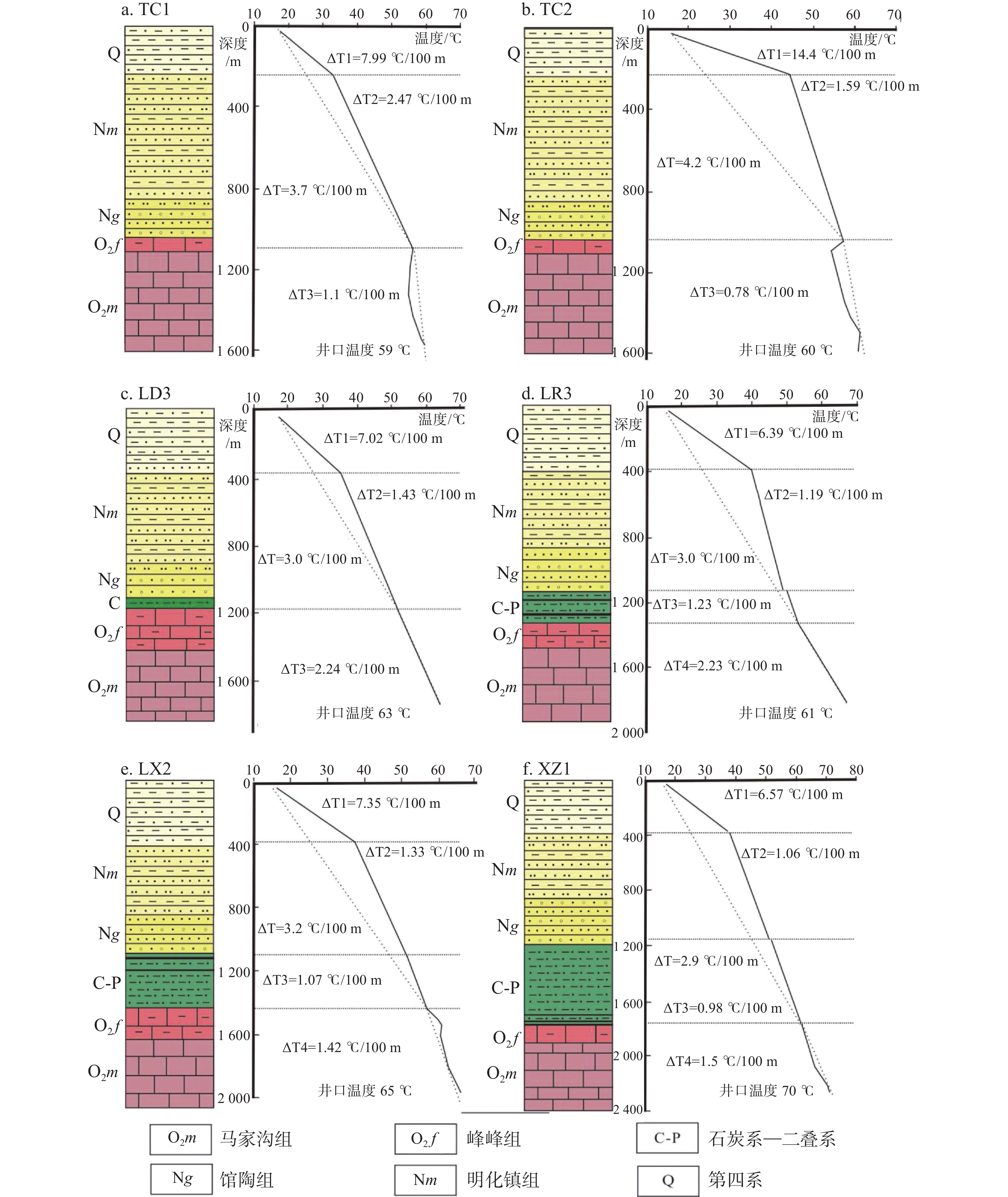
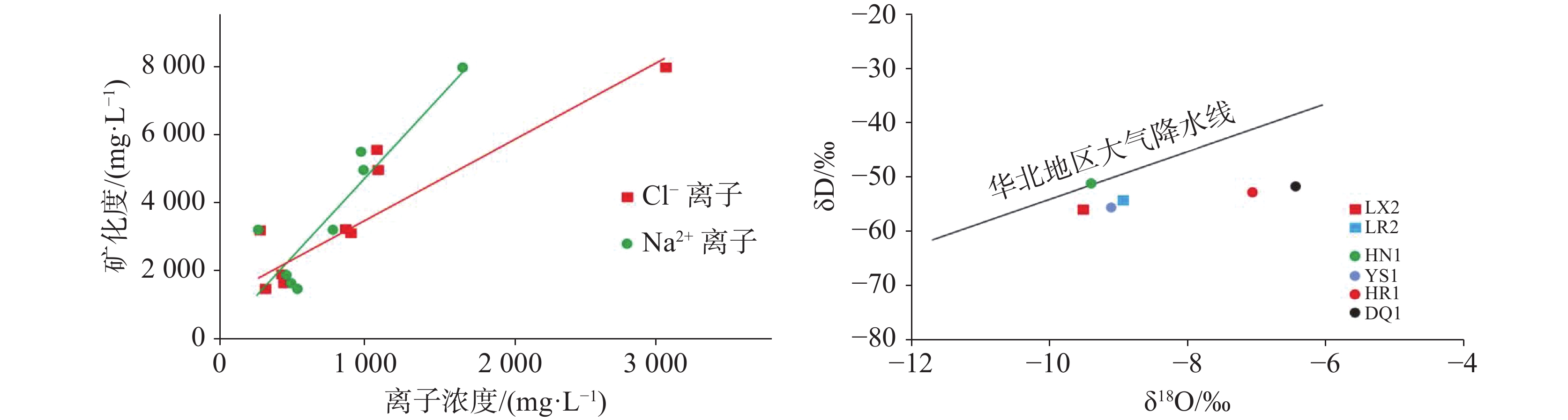
A basin-margin fault-uplift zone usually refers to the high uplift located at the edge of a faulted basin, where deep-seated faults are developed along the basin margin, and the Cenozoic fault distance can exceed thousand meters. With advancements of geothermal exploration, the uplift zone at the basin edge has become a focal point and hotspot for the exploration. Geothermal fields in this area are characterized by shallowly buried depths, favorable reservoir properties, and relatively recent accumulation. Understanding the formation mechanisms of these fields holds important theoretical and practical significance for enriching genetic models of geothermal fields in the basin and guiding their exploration and development. Taking the southern section of the Yanggu Uplift in southwestern Shandong as an example, this study systematically examines the main factors of "source, reservoir, communication, and cover" of the geothermal field based on data from drilling, logging, geophysical prospecting, production testing, and hydrochemical analysis. Using a comprehensive analysis, this study examines the genetic model of the geothermal field, and provides a detailed evaluation of its geothermal resource potential.The results indicate the following: (1) Ordovician karst thermal reservoirs are developed in this area, distributed predominantly in a northeast direction. The top surface of the thermal reservoir is buried at a depth of 1,000 to 1,800 m, becoming shallower toward the north and east and deeper toward the south and west. Taking the Lanliao Fault and secondary faults as boundaries, the study area is divided into three zones: the fault-uplift zone, the fault-terrace zone, and the deep fault zone. In the fault-uplift zone, the top surface of the thermal reservoir is buried at a depth of 1,000 to 1,200 m, with wellhead water temperatures ranging from 59 to 62 ℃. In the fault-terrace zone, the buried depth is 1,200 to1,400 m, and wellhead water temperatures range from 62 to 64 ℃. In the deep fault zone, the buried depth ranges from 1,400 to 1,800 m, with wellhead water temperatures between 64 and 70 ℃. (2) The overall thickness of the Ordovician strata is 600 to 780 m. Vertically, from oldest to youngest, the formations are the Yeli Formation, Liangjiashan Formation, Xiamajiagou Formation, Shangmajiagou Formation, and Fengfeng Formation. The main thermal reservoirs are the Fengfeng Formation, Shangmajiagou Formation, and the upper section of Xiamajiagou Formation, characterized mainly Class I and Class II fractures. The average thickness of the thermal reservoir is 98 m, with an average porosity of 9.2%. Fractures are more developed around the deep fault and at the core and leading edge of the anticline, facilitating the formation of dominant water-rich areas. The permeability coefficient in these zones exceeds 2 m∙d−1. Conversely, the transition zone between the anticline core and the deep fault,where fractures are poorly developed,exhibits permeability coefficient below 0.3 m∙d−1, indicating weak permeability. (3) The southern section of the Yanggu Uplift is affected by the Lanliao deep fault and the bedrock uplift. The average geothermal flow is 68 mW∙m−2, with the highest values along the Lanliao Fault ranging from 70 to 90 mW∙m−2, indicating a favorable thermal background. The average geothermal gradient of the cap rock is 2.9 to 4.2 ℃∙hm−1. The high-value area, exceeding 4 ℃∙hm−1, is located in the fault-uplift zone, while the low value area, below 3.0 ℃∙hm−1, is located in the deep fault zone. (4) Based on the analysis of hydrogen and oxygen isotope characteristics of water, the geothermal water in this area comes from atmospheric precipitation, with a recharge elevation ranging from 278 to 620 m. Considering the local geomorphological conditions, it is inferred that the geothermal water mainly derives from the atmospheric precipitation infiltrating the exposed bedrock in the Liangshan and Jiaxiang areas to the east. In the study area, from east to west, the geothermal water migrates along faults and karst unconformity surfaces, heating as it moves into shallow thermal reservoirs. Water ultimately accumulates in uplifted regions, where heat transfer mode is predominantly governed by conduction, resulting in a medium- to low-temperature geothermal field. The circulation depth of geothermal water is 2,219 to 3,692 m. The hydrochemical type evolves from SO4·Cl-Na·Ca to Cl·SO4-Na·Ca from east to west. The TDS is 3,240 to 8,004 mg∙L−1. (5) Using the method of thermal reservoir volume, the Ordovician geothermal resources in the southern section of the Yanggu Uplift were comprehensively evaluated based on both horizontal zones and vertical stratifications. The calculation indicate that the total geothermal resources in this area amounts to 28.10×10¹⁸ J, equivalent to 0.96×10⁸ t of standard coal. The annual exploitable geothermal resources can support heating for an area of 505×104 m2, indicating promising development prospect.
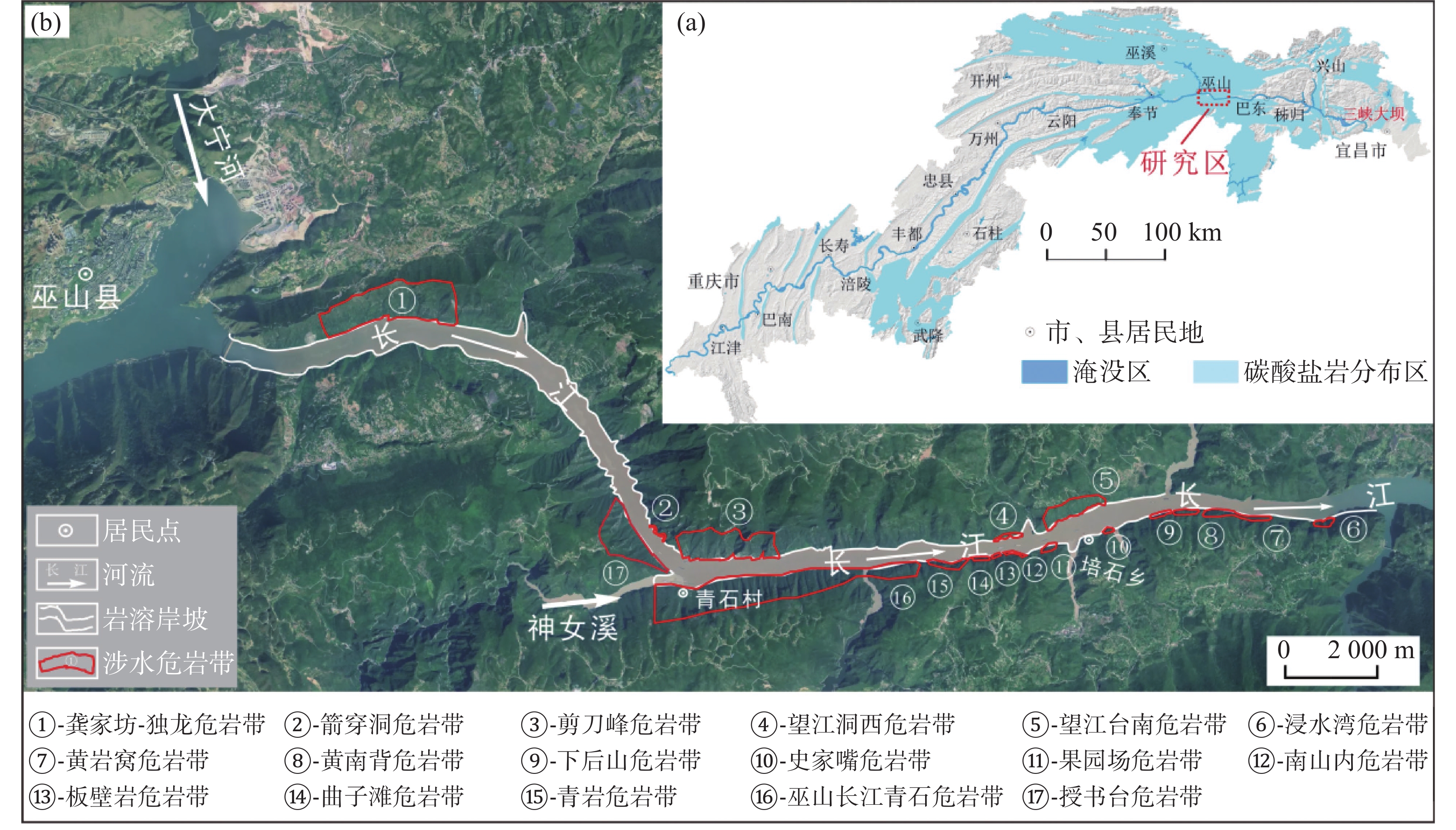
Identification and development characteristics analysis of underwater rock-cells in the karst bank slope of the Wu Gorge section,Three Gorges Reservoir Area
GONG Cheng, GUAN Zhende, MENG Yan, YANG Yong, HUANG Hai
2026, 45(1): 167-178. doi: 10.11932/karst20260110
Abstract:
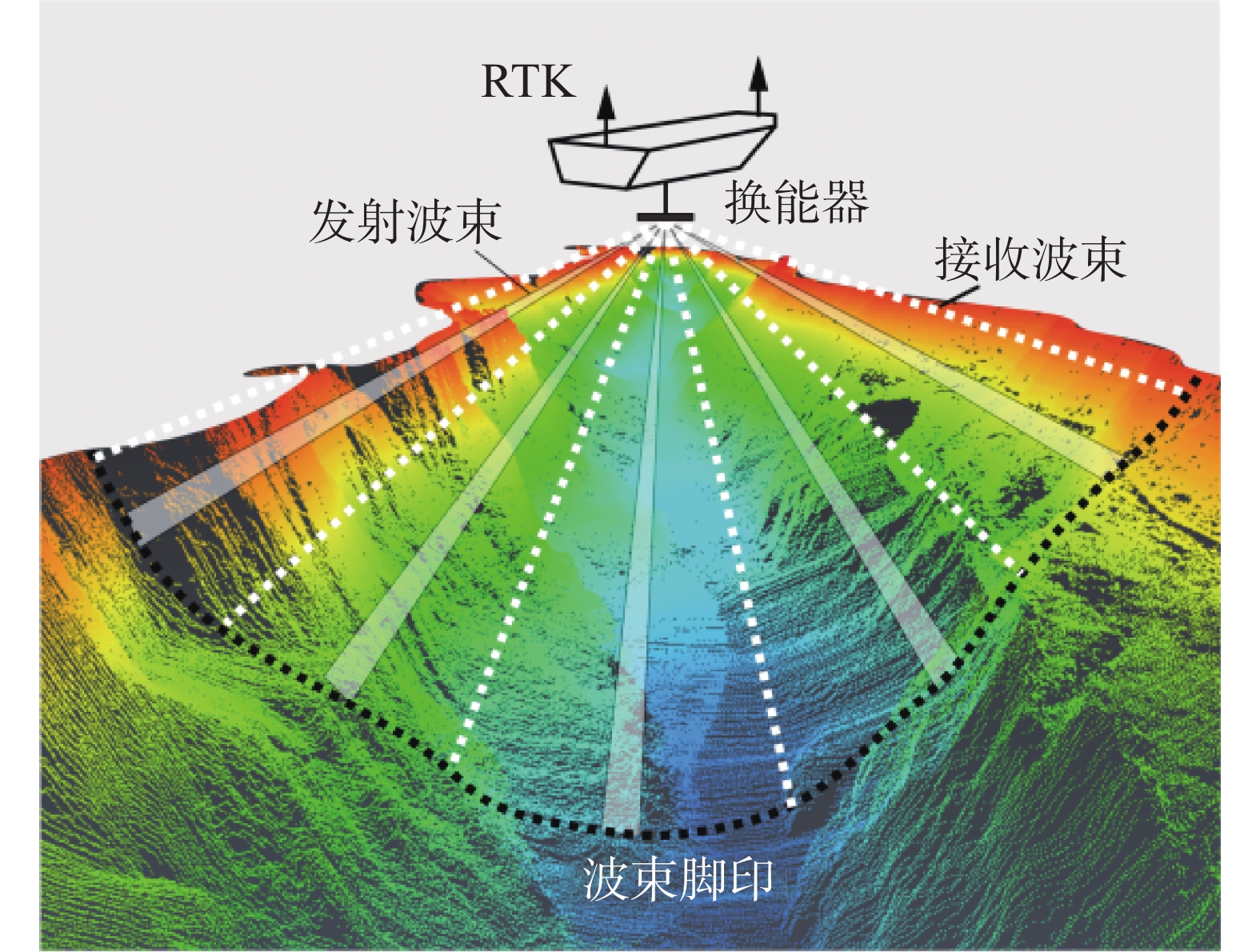
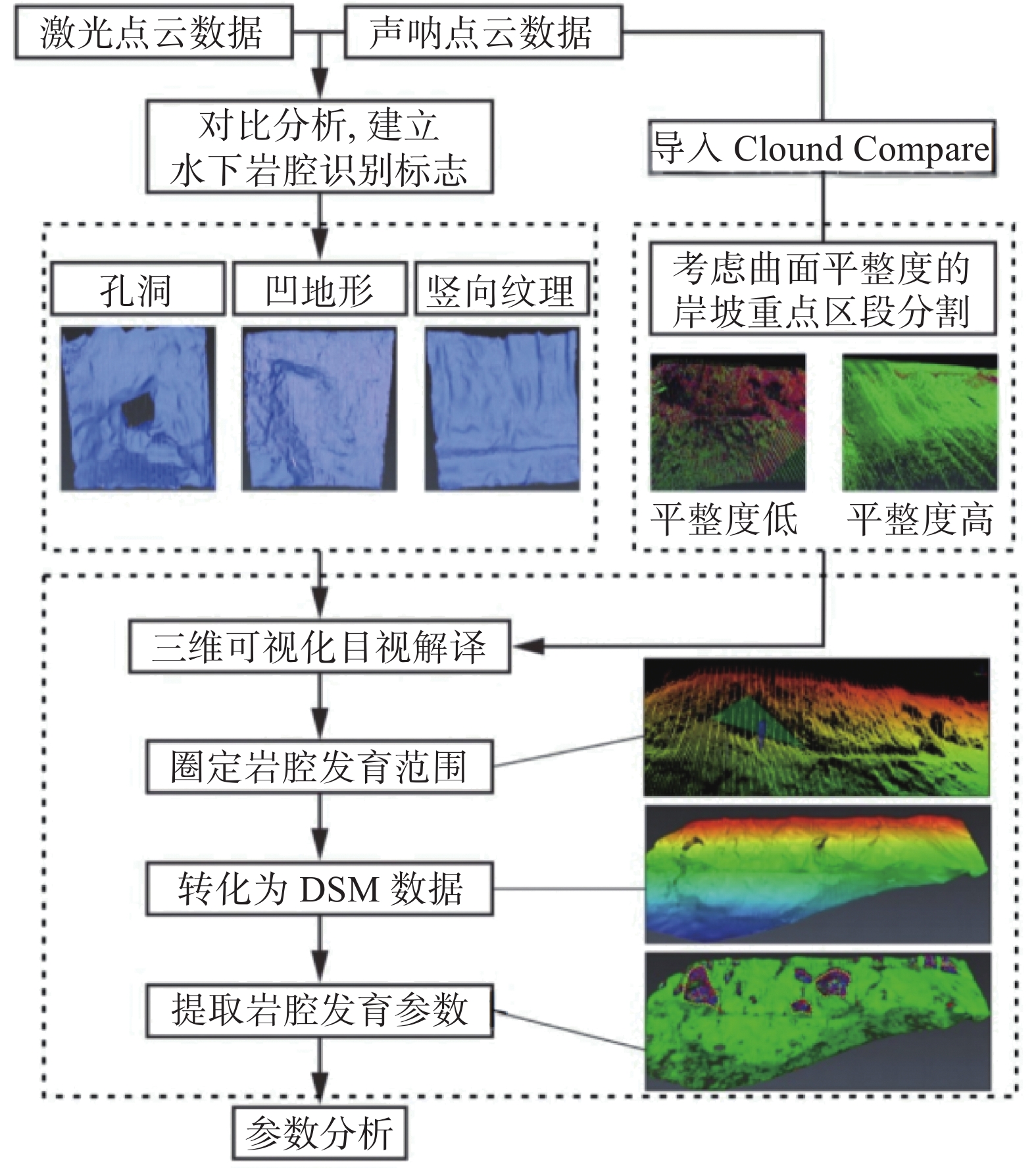
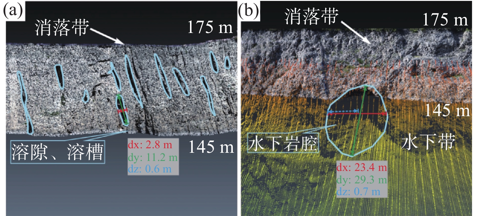
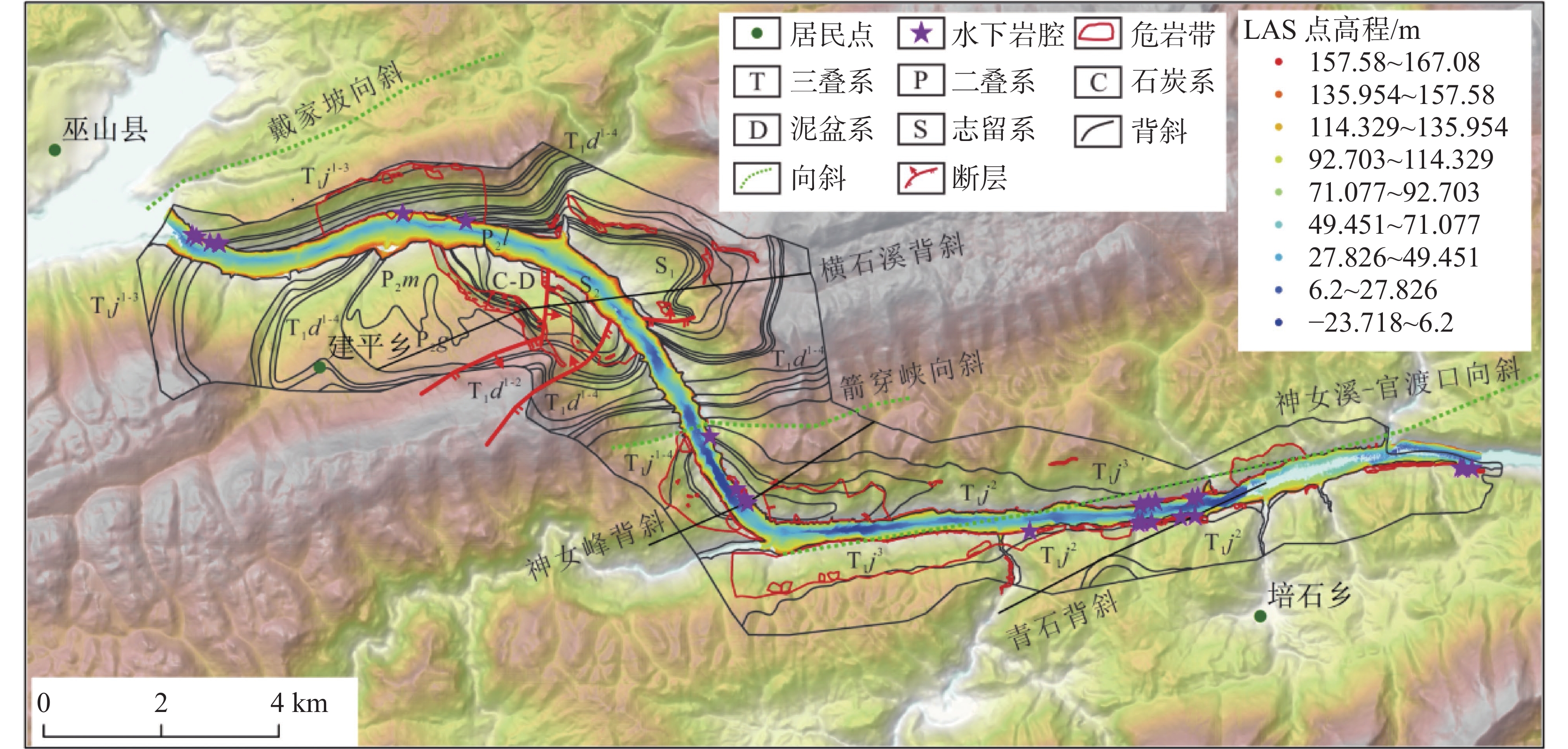
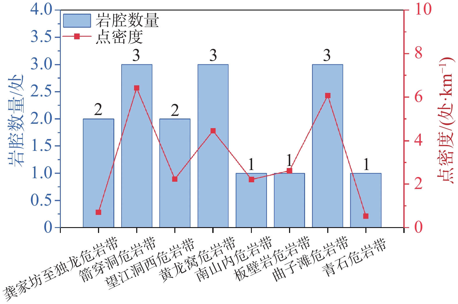
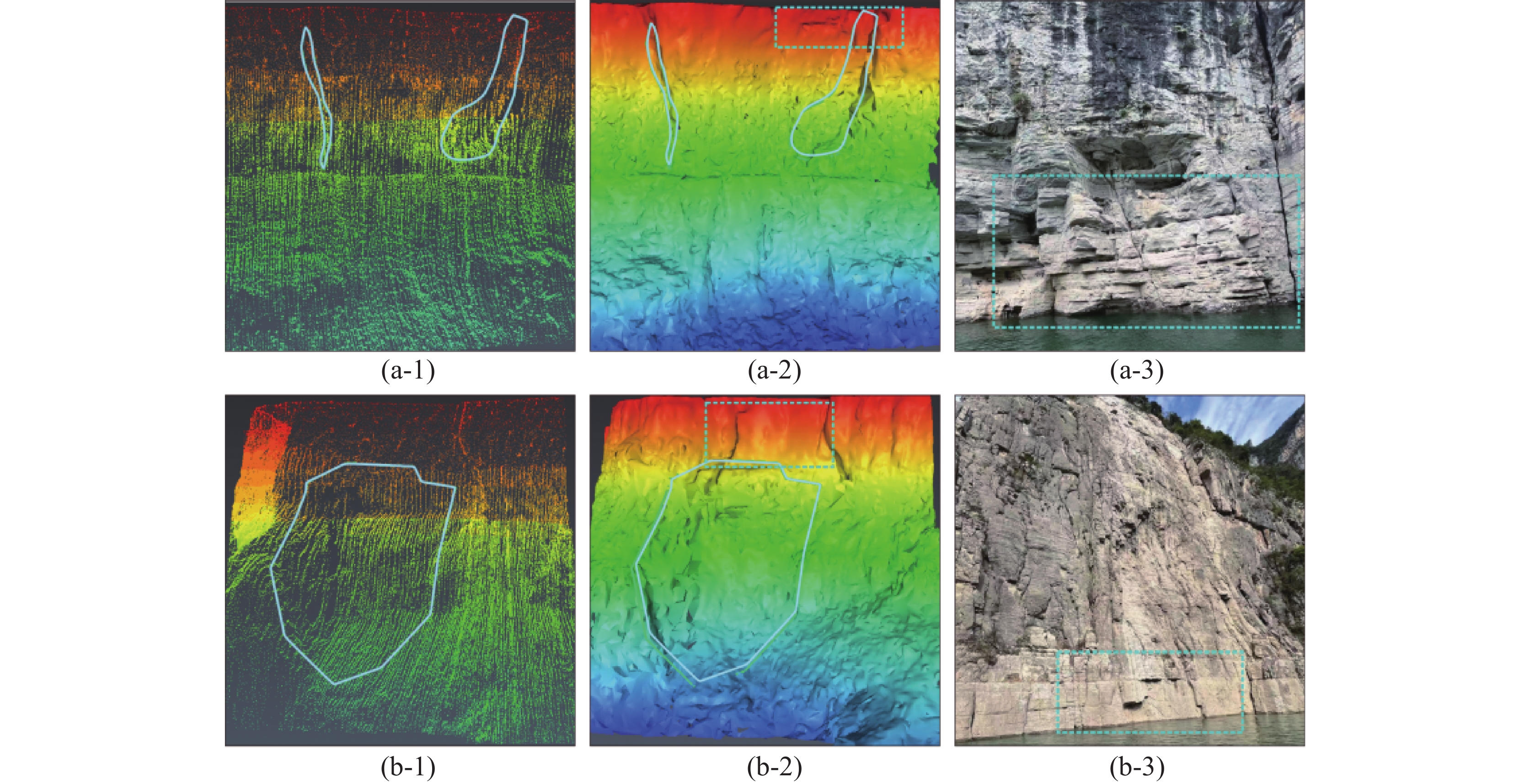
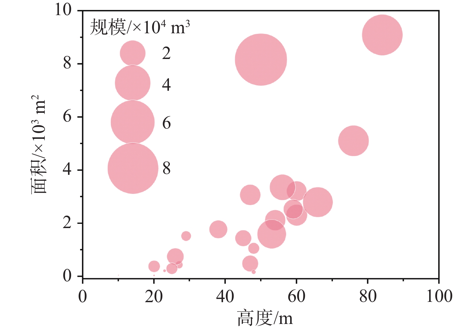
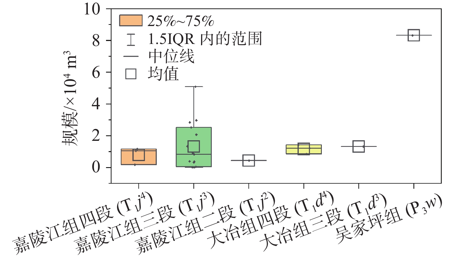
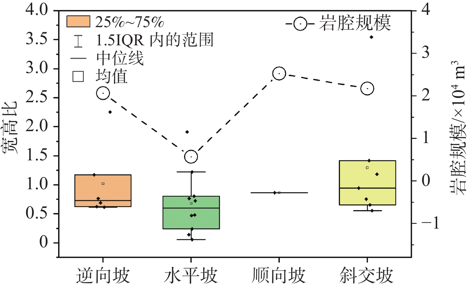
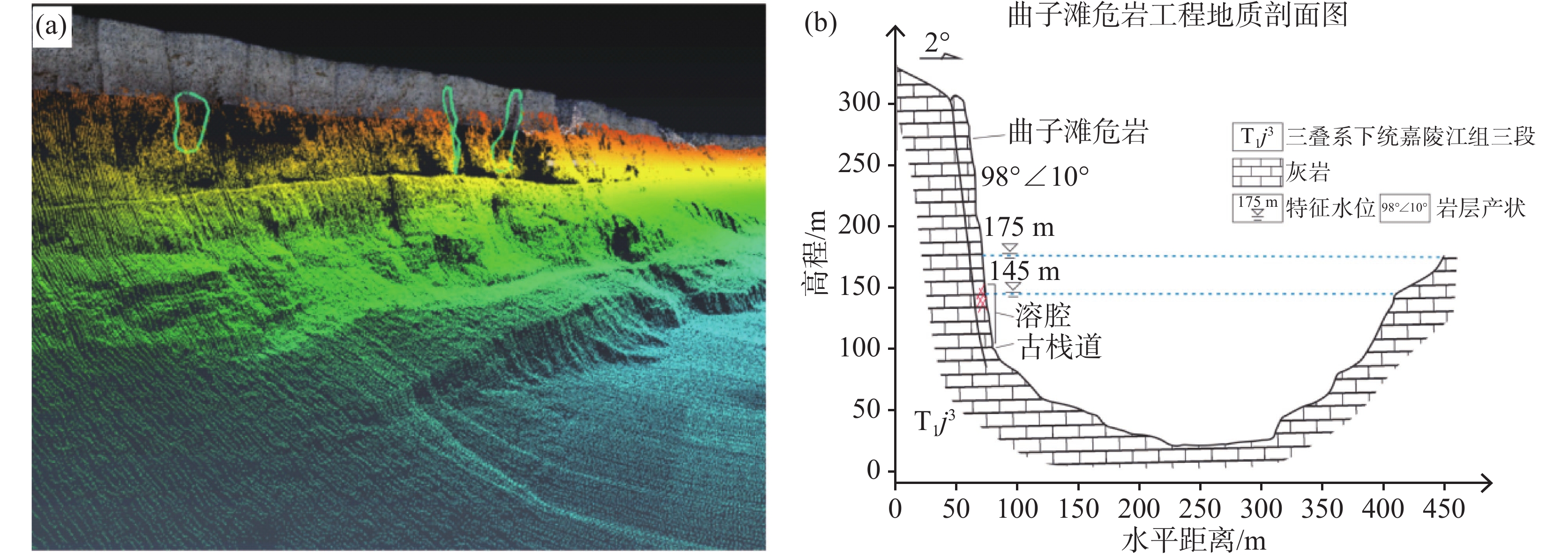
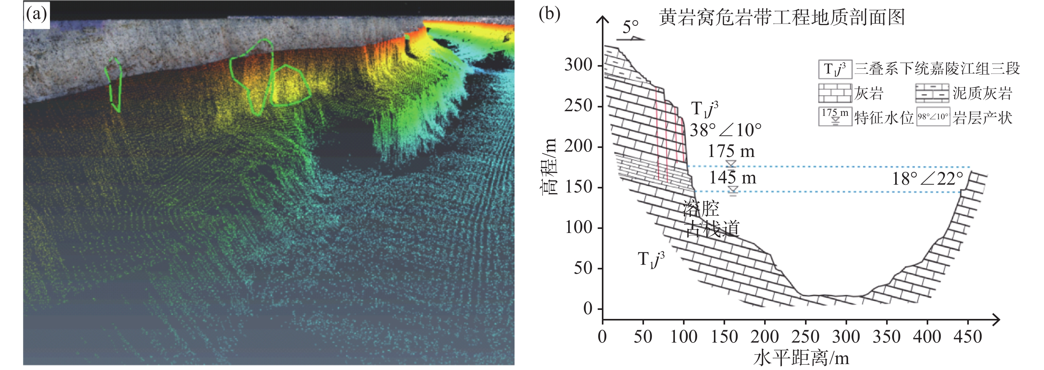
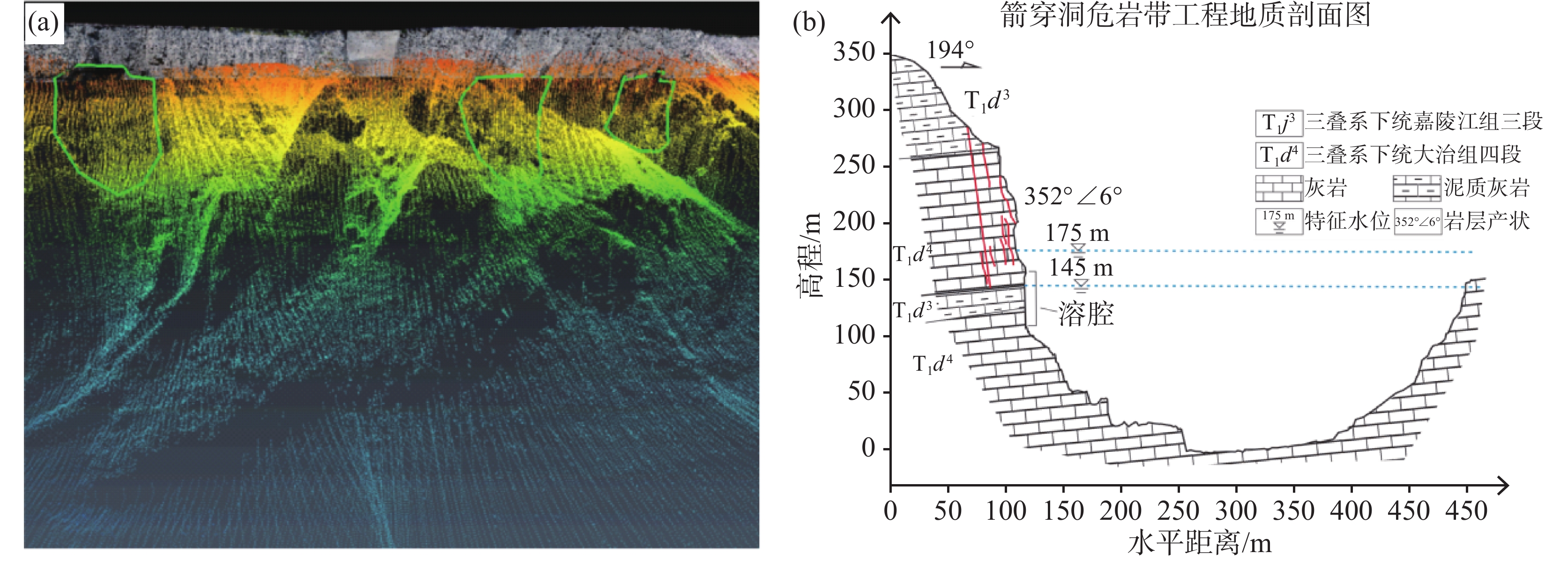
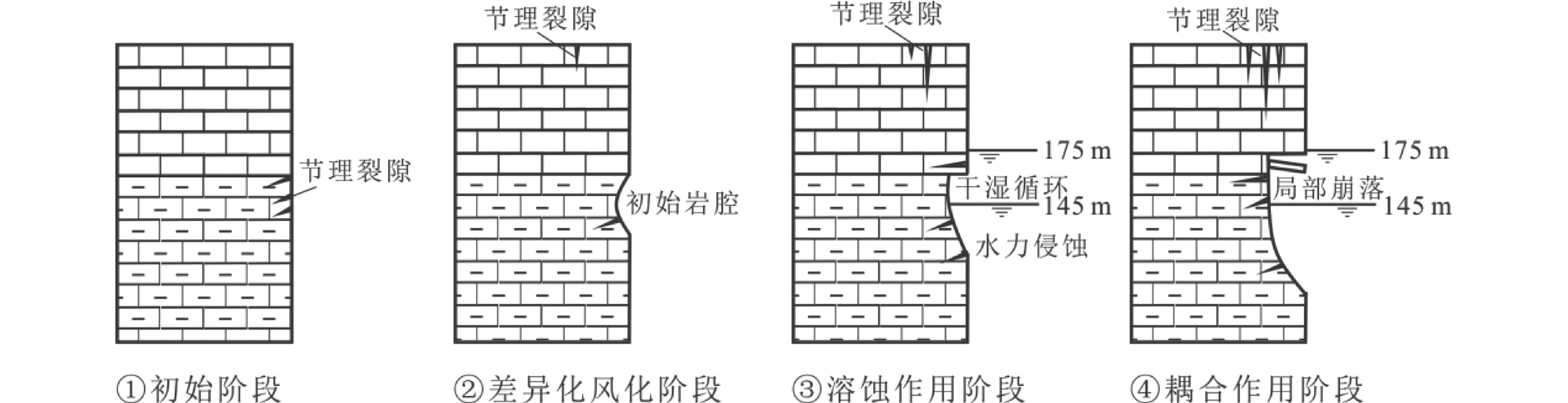
The Wu Gorge section of the Three Gorges Reservoir Area is located in the border zone between the Daba Mountains in northeastern Chongqing and the mountains in western Hubei, administratively under the jurisdiction of Wushan county in Chongqing, about 400 kilometers away from the Chongqing urban area. The area is located in the karst mountainous area, affected by dissolution, unloading and geological tectonics, with a complicated geological environment, which has formed a large number of columnar or plate-like steeply standing dangerous rock bodies. Under the cyclic fluctuation of reservoir water level (145–175 m), stress release of rock body and rainfall-groundwater seepage coupling, the rock body of the bank slope undergoes multiple deterioration processes such as chemical erosion/dissolution, mechanical transportation and stress corrosion, which leads to strong deterioration of the damage of the rock body at the base of the hazardous rock body.With regard to the deterioration mechanism of karst bank slopes in the reservoir area, studies have revealed the control effect of water level fluctuation on the deterioration of rock bodies by means of on-site investigation, in-situ testing, and indoor experiments. The results reveal that reservoir water fluctuation accelerates the differential dissolution of carbonate rocks by changing the CO2 partial pressure and water-rock contact time; in addition, hydraulic hollowing results in the continuous transportation of weak interlayers and fissure fill, forming a rock-cell structure extending into the mountain mass. Although existing studies have already explained the chemical-mechanical coupling mechanism of rock degradation in the draw down zone of bank slopes, there is still a lack of systematic knowledge about the development characteristics of submerged rock-cells on bank slopes and their influence on the long-term stability of the upper critical rocks. Relevant studies have shown that the basal rock cavity structure of high-steep slopes is both a sensitive indicator of the accumulation of rock damage and a key potential boundary of rock destabilization, and the morphology of the basal rock cavity and the depth of the cavity development have a significant controlling effect on the fracture damage mode and destabilization mechanism of large-scale collapses. However, due to the limitation of detection technology, it is difficult to obtain the distribution and geometrical parameters (e.g., cavity size and cavity depth) of cavities in the submerged section (below 145 m) of the bank slope drawdown zone in the traditional geological surveys, which restricts the understanding of the long-term stability of water-related hazardous rocks. In recent years, Multi-Beam Echo Sounding System (MBES) has provided a new way to recognize complex underwater structures with high accuracy by using high-density topographic data acquisition capability. In this paper, the Wu Gorge section of the Three Gorges Reservoir Area is selected as the study area, and the MBES combined with three-dimensional sonar point cloud data fusion analysis technology is used to construct a technical method for detecting and identifying underwater rock cavities in karst slopes in the reservoir area, and identify the spatial distribution pattern and developmental characteristics of the underwater rock cavities in the study area. The results show that: (1) A total of 24 underwater rock cells are developed in the Wu Gorge, with 66.7% coexisting with water-related unstable rock zones, particularly in the Jianchuandong, Huangyanwo, and Quzitan unstable rock zones exhibiting the highest density. (2) The planar morphologies of underwater rock cells are classified as inverted funnel-shaped and elliptical, with the former controlled by vertical tectonic joint propagation and the latter governed by a coupled "dissolution-collapse" catastrophic process. (3) The development of underwater rock cells is influenced by multiple factors, including lithology, slope structure, and fold tectonics. Lithologically, they are concentrated in the third member of the Jialingjiang Formation (T1j3) of the Triassic period, comprising thin to medium-bedded limestone interbedded with argillaceous limestone (accounting for 62.5%). Tectonically, three predominant developmental zones are formed at the contacts of the Shennvfeng anticline, Qingshi anticline core strata, and the southern wing of the Shennvxi-Guandukou syncline. In terms of slope structure, horizontal slopes (41.7%) and oblique slopes (29.2%) dominate, with large-scale underwater rock cells primarily developing on oblique slopes.These findings provide precise insights into the developmental status of underwater rock cells in the Wu Gorge of the Three Gorges Reservoir Area, offering a scientific basis for subsequent targeted rockfall monitoring, reinforcement, and other protective measures.
Analysis of the formation mechanism of karst collapse in the Panlong lead-zinc mine, Wuxuan, Guangxi
LU Danmei, DENG Zhong, YAO Kezhui, ZENG Jiahua, WANG Shengjie, QUAN Lyuxing, GUO Deheng, TIAN Peng
2026, 45(1): 179-192. doi: 10.11932/karst20260111
Abstract:
Karst collapse is a major geological hazard in karst areas, characterized by suddenness and concealment. Over the years, human engineering activities-such as mining at the Panlong lead-zinc mine in Wuxuan, Guangxi, and the impoundment of the Datengxia Reservoir-have triggered more than 100 karst collapse events in the mining area. These events pose serious threats to human life, property, and public safety. To elucidate the development patterns and triggering mechanisms of successive karst collapses at the Panlong lead-zinc mine, comprehensive investigations and studies were conducted. These include field surveys, hydrogeological and engineering geological drilling, geophysical exploration, long-term groundwater dynamic monitoring, and in-situ hydrogeological testing. The main research findings are as follows.1. The fragile geological environment, characterized by moderately-to highly-developed underground karst, thin overburden layers, and moderate- to abundant groundwater resources, constitutes an intrinsic factor for karst collapse.The study area is extensively developed with underground karst features that serve as storage spaces or transport channels for groundwater and collapse materials. Groundwater resources are abundant, while the overburden layers are relatively thin, and the soil exhibits poor engineering geological properties, facilitating the formation of soil caves due to groundwater activity. These fragile geological environmental conditions are the internal cause of karst collapse in the study area.2. Long-term, large-scale groundwater dewatering is a key anthropogenic factor inducing karst collapse in the study area.Mine drainage has caused a rapid decline in groundwater levels, an increase in groundwater hydraulic gradient, and an enhanced erosion capacity of groundwater on the overlying soil. Long-term mine drainage, combined with the effects of rainfall (especially heavy rainfall) and reservoir impoundment on groundwater within the cone of depression, results in significant and frequent fluctuations in groundwater levels. These fluctuations are a critical external factor contributing to karst collapse in the study area.3. Based on the mining process and characteristics of collapse occurrences, karst collapse events at the Panlong Lead-Zinc Mine can be divided into three stages: the formation stage of depression funnel, the stabilization stage of depression funnel, and the impoundment stage of reservoir. The dominant geological forces and collapse modes vary moderately across these stages.(1) Formation stage of depression funnel: Mine drainage causes a decline in groundwater levels, forming a depression funnel and altering regional hydrogeological and engineering geological conditions. Before mining, the soil was mostly in a pressured, saturated state; however, after the sudden drop in water levels, it lost water buoyancy support, resulting in reduced stability and increased load effects. In addition, the increased groundwater flow velocity enhances soil transport capacity, while karst pipelines act as discharge channels for soil particles, thereby promoting the development of soil caves. Meanwhile, the rapid decline in water levels generates negative pressure within karst caves, triggering collapse under the combined effects of erosion and negative pressure.(2) Stabilization stage of depression funnel: Under specific mining depths, the drainage remains stable, and the depression funnel temporarily stops expanding. However, the dewatering effect continues, maintaining groundwater levels below the bedrock surface for an extended period. Sudden fluctuations in water and gas pressure within karst pipelines caused by heavy rainfall are the main triggering factors. For instance, six concentrated collapses occurred after a 120 mm heavy rainfall event on June 11, 2022. This heavy rainfall caused a sharp rise and fall in groundwater levels, forming an alternating cycle of positive and negative pressures. The rising water levels triggered a gas explosion effect, while the subsequent decline intensified seepage erosion and negative pressure effects. The combination of these factors with pre-existing soil caves ultimately resulted in collapse.(3) Impoundment stage of the Datengxia Reservoir: After the reservoir was impounded in March 2020, the water level of the Qianjiang River rose to 35–53 m. Changes in river water levels, combined with the effects of mine drainage and rainfall, exacerbated fluctuations in groundwater levels. During impoundment, river water recharges the groundwater, causing its level to rise; during regulation and storage phases, the decline in river water levels leads to a corresponding drop in groundwater levels. High-frequency variations in mine drainage result in frequent and significant fluctuations in groundwater levels, providing sufficient hydrodynamic and aerodynamic conditions for the formation, expansion, and collapse of soil caves.
Evaluation of karst hydrogeological conditions and reservoir leakage analysis in the basin of Yangquan River, Fengjie county, Chongqing
WU Jian, MI Xiangli, LAN Meng
2026, 45(1): 193-207. doi: 10.11932/karst2025y014
Abstract:
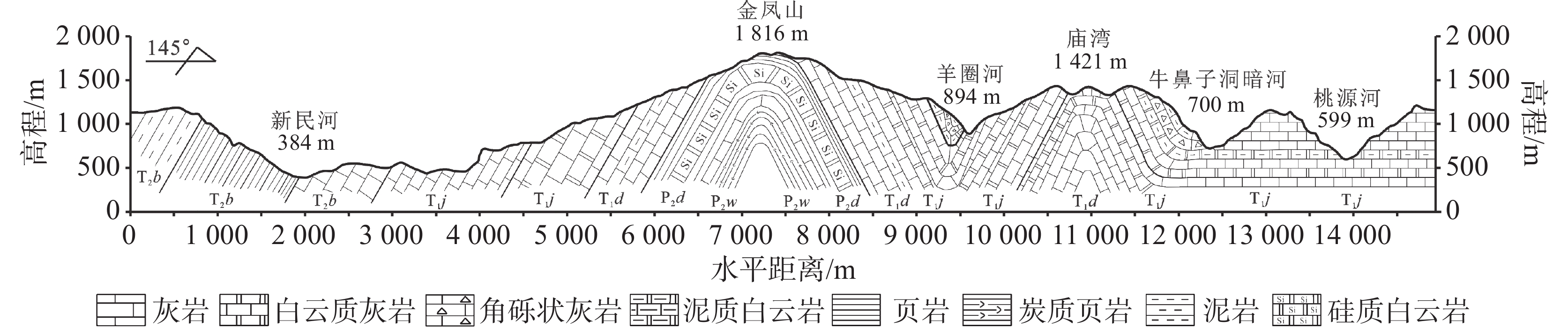
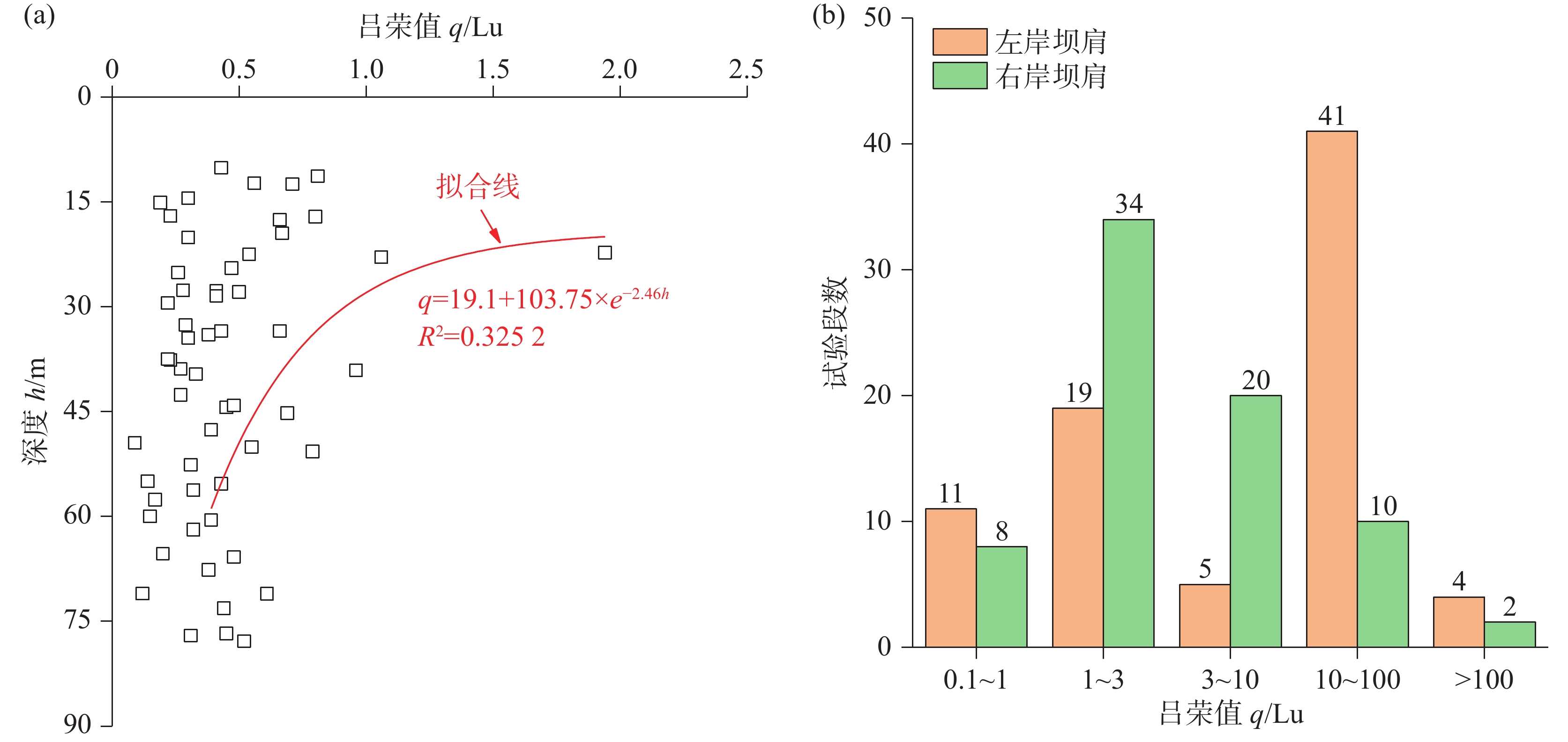
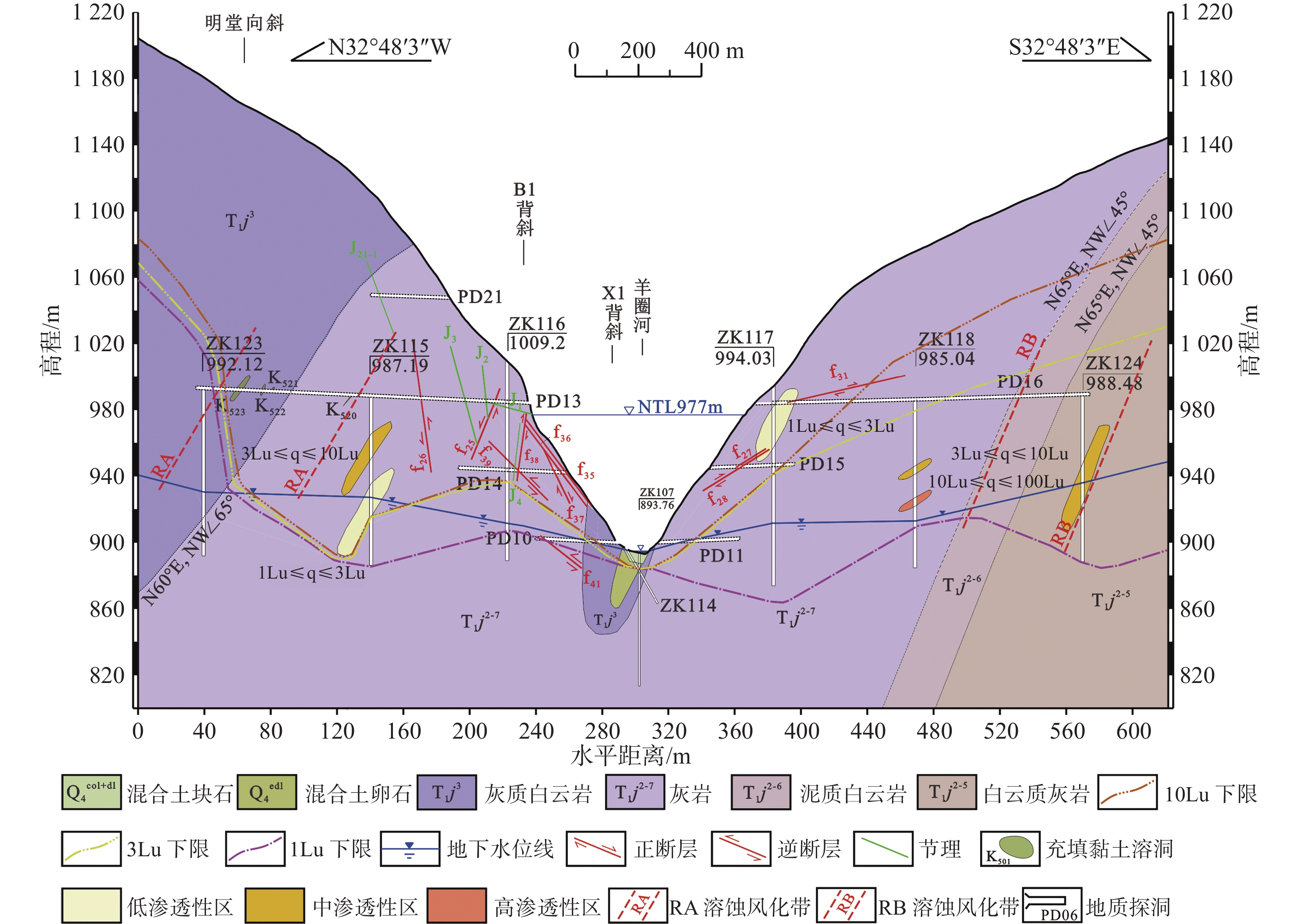
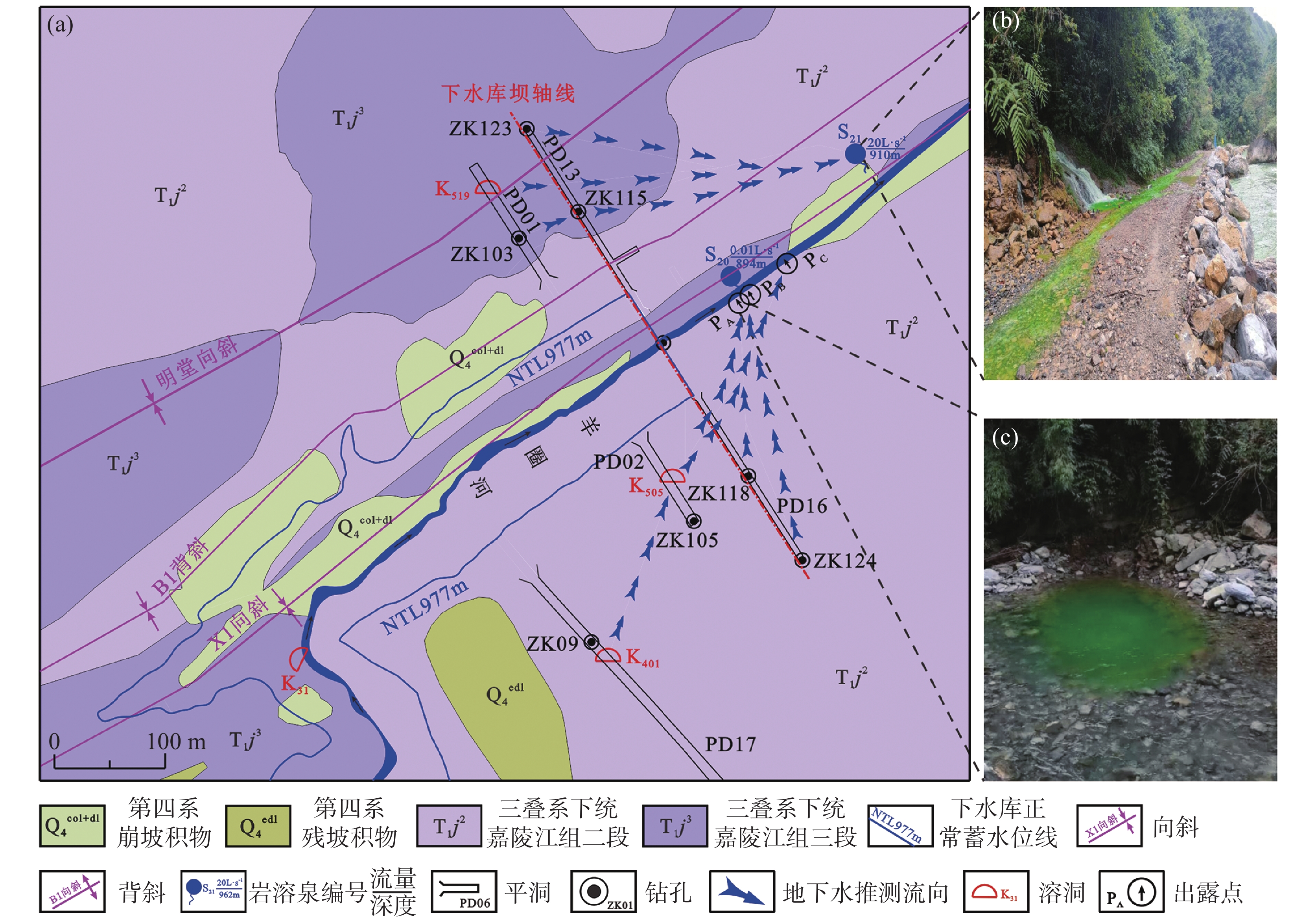
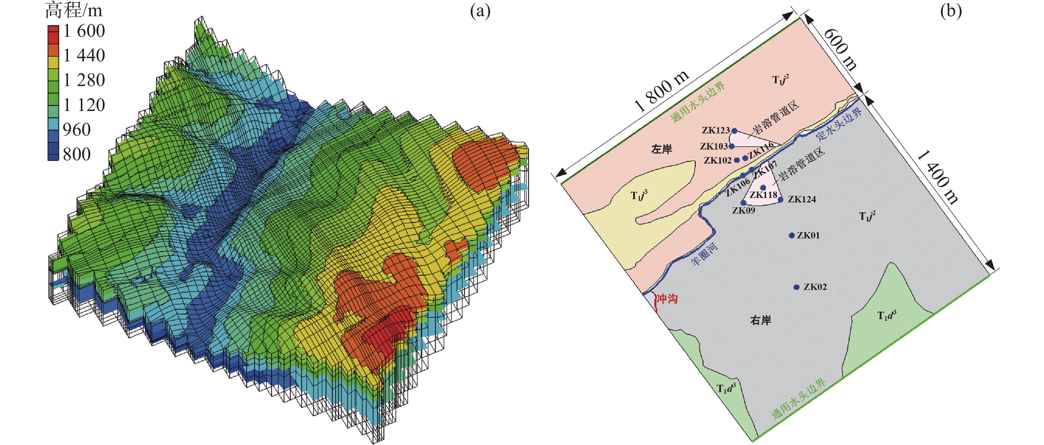
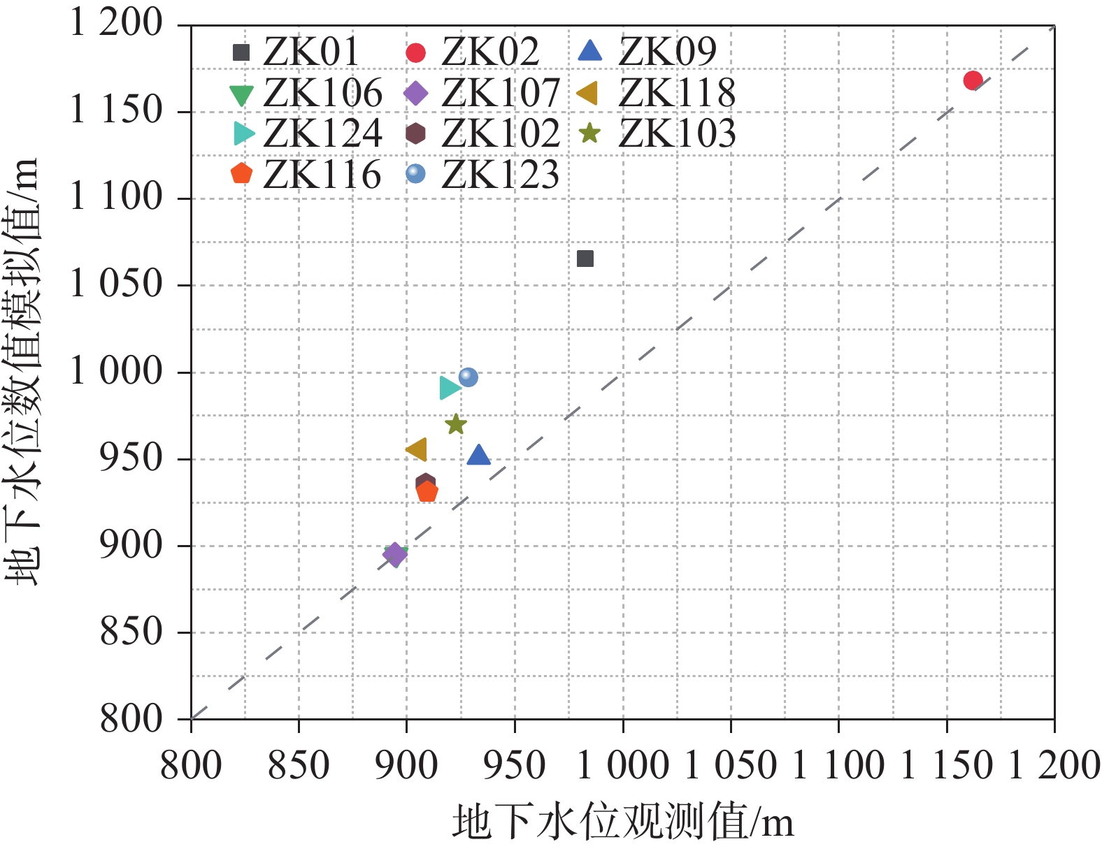
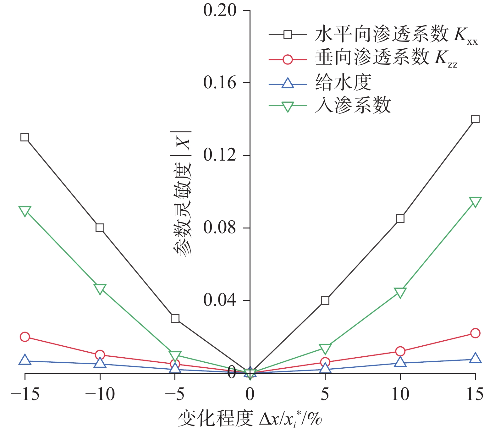
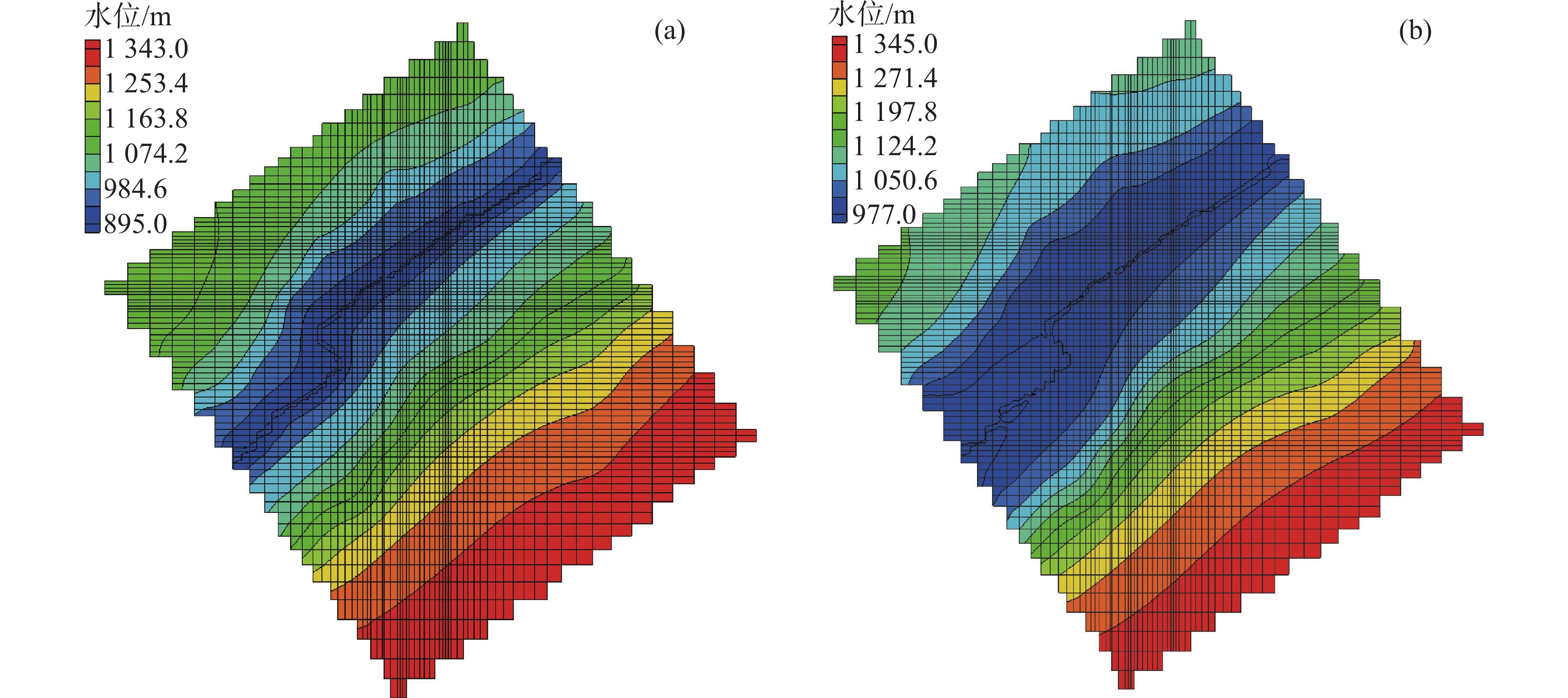
Southwest China constitutes the world's largest karst region with concentrated exposure and distribution of carbonate rocks.Within this area, Chongqing is a pivotal component of the southwestern karst system, with karst landscapes covering approximately 30,000 km2, primarily concentrated in the northeastern and southeastern of Chongqing This region has experienced multiple phases of strong karstification, resulting in well-developed karst landforms such as solution caves, sinkholes, karst springs, and underground rivers. Abundant surface water and groundwater have triggered frequent karst geohazards, including reservoir leakage, water inrush in tunnels, and karst collapses. These events have seriously constrained the safety construction of hydraulic projects and local economic development.The Yangquan River basin in Fengjie county, Chongqing covers an area of approximately 45.5 km2, with a total river length of about 14 km. The daily average river water level is 895.1 m, while the average annual flow is 0.686 m3∙s−1, corresponding to a average annual runoff of 21.63 million m3. The basin has a subtropical warm and humid monsoon climate, characterized by an average annual precipitation of 1163.1 mm, an average annual evaporation of 1267.8 mm, and an average annual temperature of 18.7 ℃. Limestone and dolomite strata are developed in the basin, with undeveloped and small-scale faults located on the slopes of both banks. In contrast, fold structures are extensively developed, generally trending parallel to the Yangquan River. The left bank of the Yangquan River exhibits multiple gullies controlled by lithology and NW-trending fold structures. The topographic divide is the Jinfeng Mountain with elevations ranging from 1,800 m to 1,900 m. The right bank constitutes an interstream block between the Yangquan River and the Taoyuan River, characterized by a topographic divide elevation of approximately 1,450 to 1,600 m. Therefore, the left and right banks of the Yangquan River have steep topography, forming a typical "V"-shaped longitudinal valley. Overall, the karst hydrogeological conditions are complex, and karst leakage has become a crucial issue in the construction of pumped storage power stations in this area.This paper evaluates the karst hydrogeological conditions of Yangquan River basin by using geological survey and mapping, hydrogeological field experiments, and karst water system analysis. Subsequently, the karst leakage type, karst leakage location, and karst leakage passage are systematically analyzed during the impoundment of the Yangquan River reservoir. Ultimately, the three-dimensional seepage filed of the Yangquan River under natural and impounding conditions are conducted by using MODFLOW software. The karst leakage rates are calculated and validated through numerical modelling and analytical formulas. The results show that in the Yangquan River basin, karst development is mainly concentrated in the high-purity zone of carbonate rocks, structural fracture development zone, and discharge base level, forming five concentrated zones that exhibit a northeast-trending banded distribution. The degree of karst development gradually decreases with the increase of depth, exhibiting significant elevation zoning characteristics. This results in a dual shell-core structure characterized by strong karst development on the surface and weak karst development internally. Moreover, the karst groundwater system in the Yangquan River is a typical type of karstic fissure-pipeline-underground river system in the anticline mountainous of Southwest China, which can be spatially divided into strong karst anticline zone, strong karst syncline zone, and moderate karst syncline zone. Based on the water balance theory, the karst groundwater system in the site is classified as a secondary hydrogeological unit, namely II-2 interstream block. The recharge, runoff, and discharge modes of karst groundwater in the basin are primarily characterized by rainfall infiltration and concentrated drainage through longitudinal-transverse conduit-fissure flow systems. Packer tests and groundwater tracer tests indicate that the left bank of the Yangquan River develops an interconnected karst conduit system, while the right bank exhibits a dual-media system composed of fissure networks and karst conduits. During the impoundment of the lower reservoir in the Yangquan River, pore leakage may occur at the dam foundation, while karstic pipeline leakage and karstic pipeline-fissure coupling leakage may develop on the both left and right banks; however, there will be no leakage in the lower adjacent valley. The analytical solutions for the pore leakage and karstic pipeline leakage are 9,505.13 m3∙d−1 and 117,979.20 m3∙d−1, respectively. As a comparison, the numerical result of karst leakage is approximately 12,184.60 m3∙d−1, indicating that more efficient and reasonable numerical methods and anti-seepage control measures need to be adopted to address karst groundwater pipeline system on both banks to achieve the conditions for dam construction and reservoir formation. This study can provide some suggestions for hydraulic projects in Southwest China.
Karst development characteristics and karst cave treatment technology of a large-scale engineering site in Longgang
XIONG Xing, ZOU Hui, HUANG Zhe, PEI Junyong, YIN Xiaodong, ZHONG Wenjie
2026, 45(1): 208-220. doi: 10.11932/karst2025y029
Abstract:
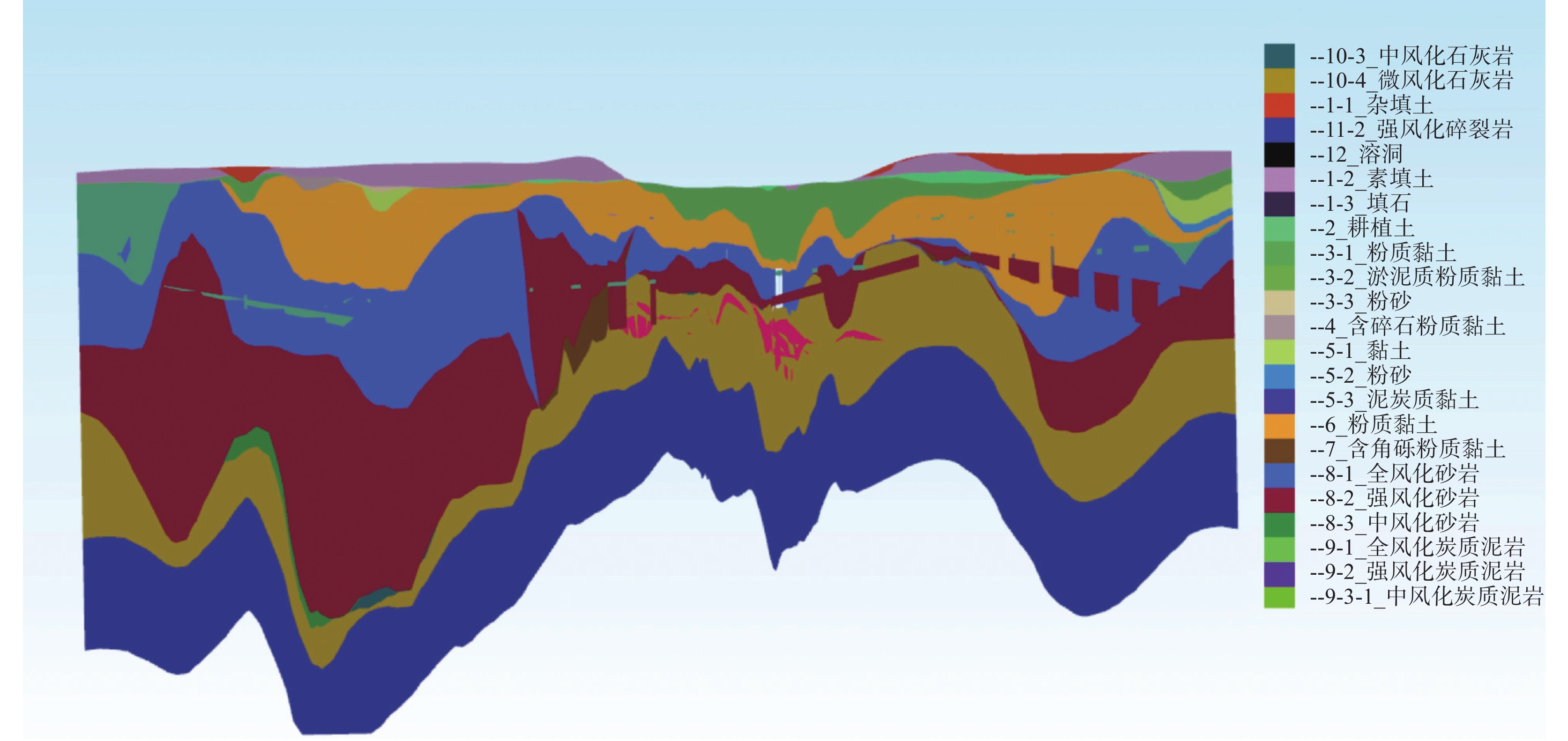
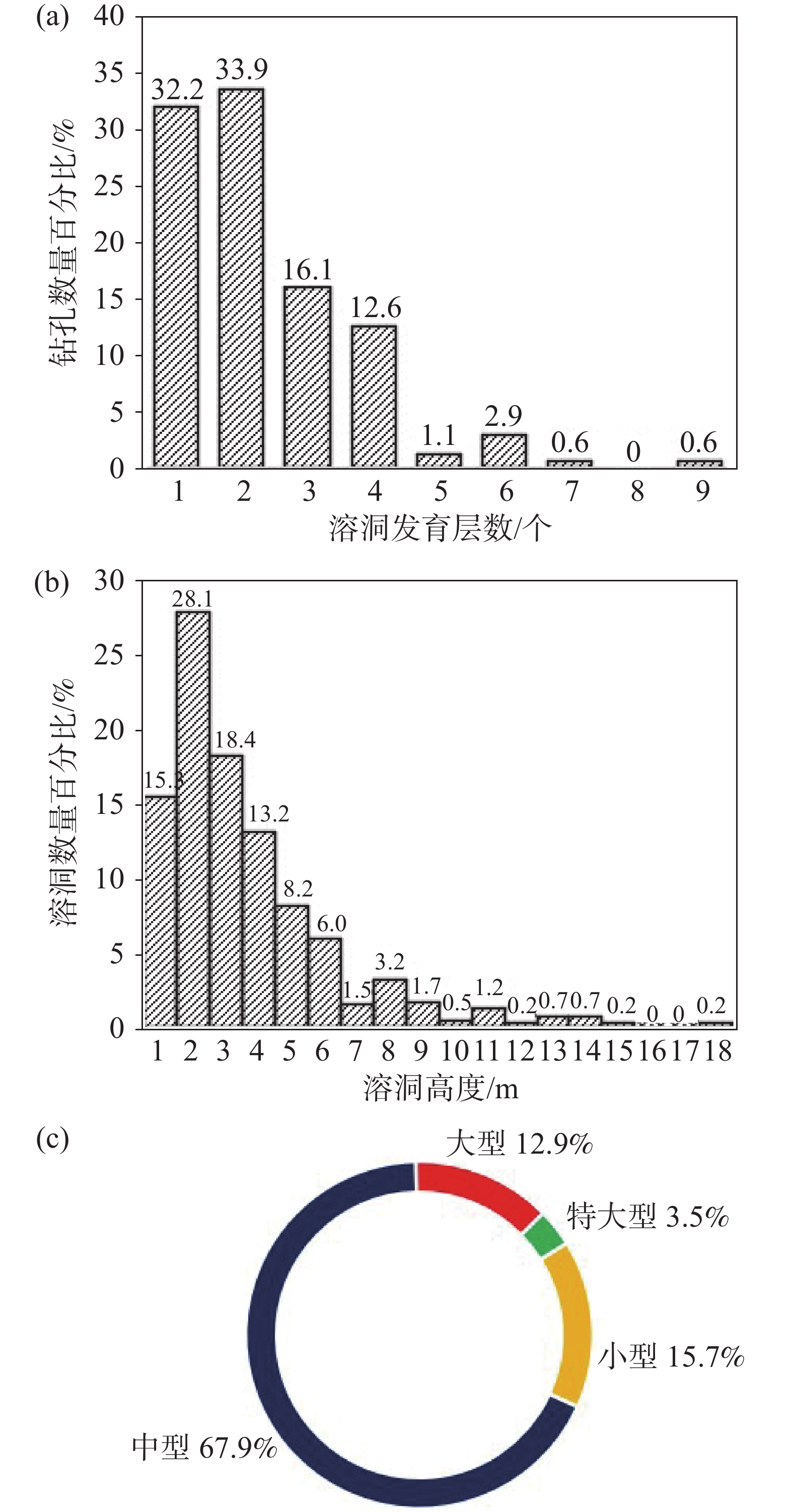
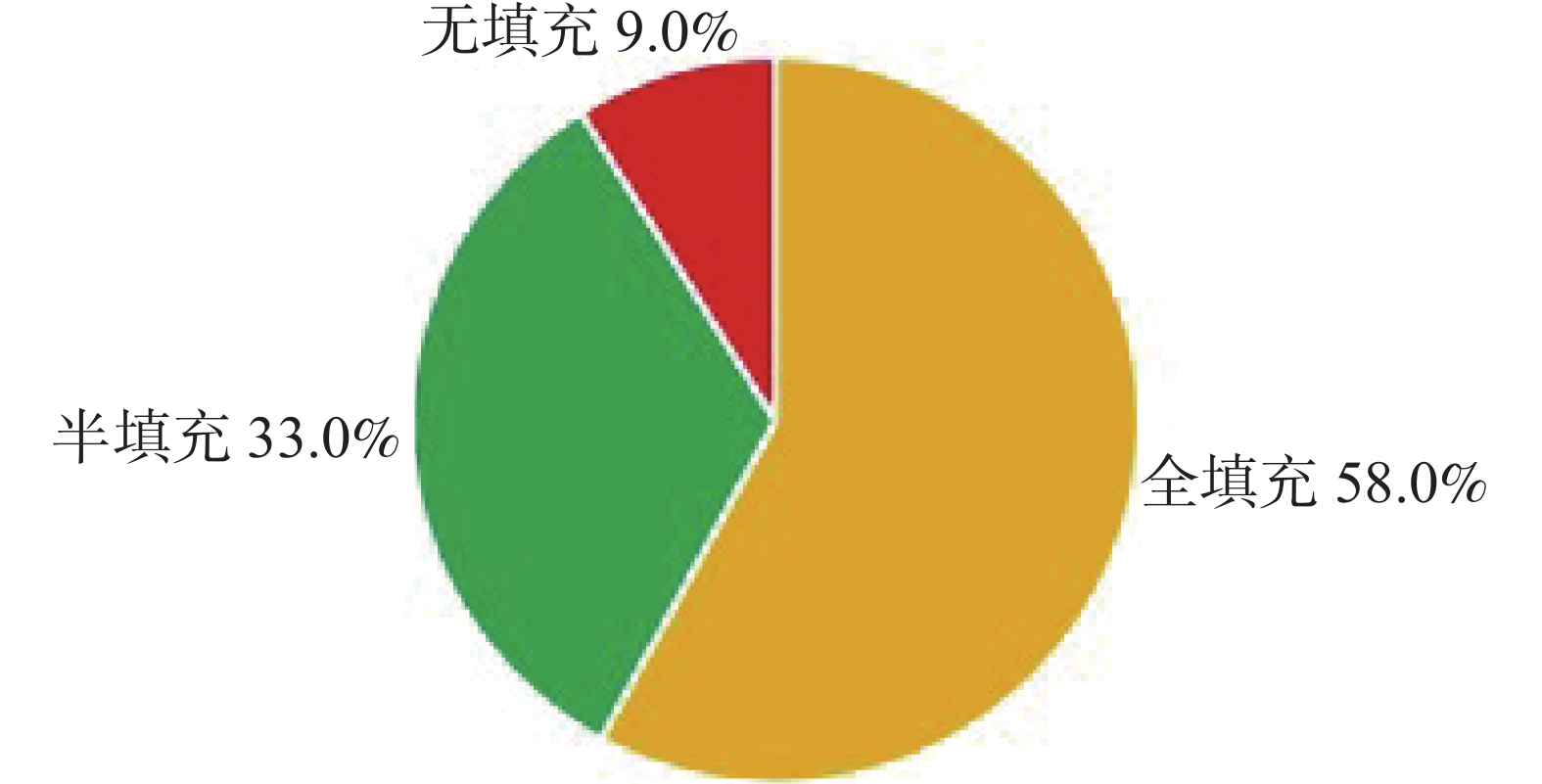
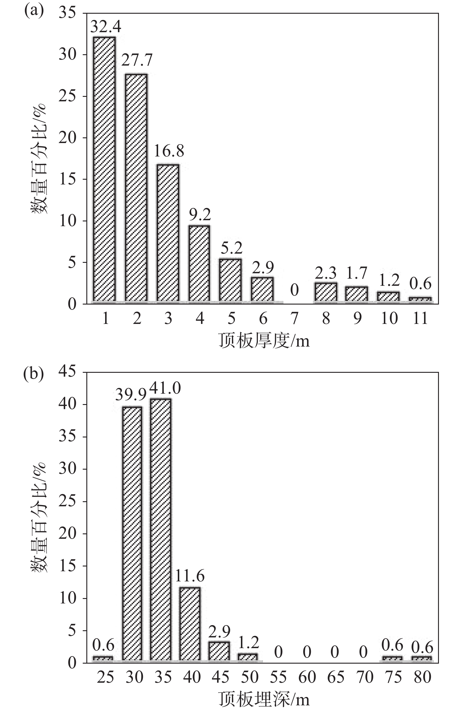
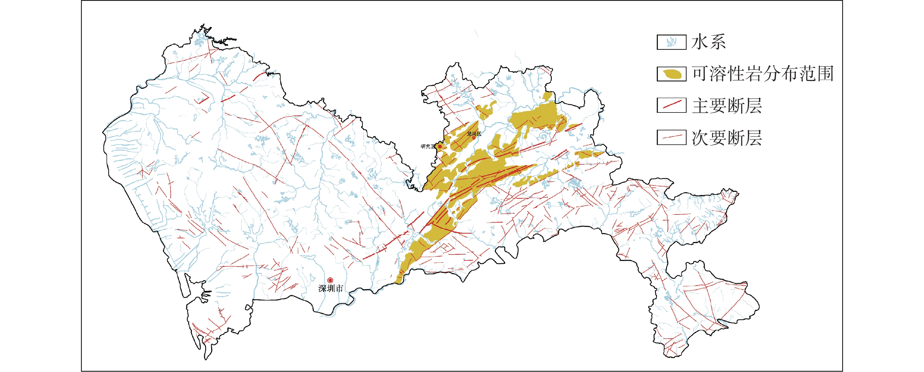
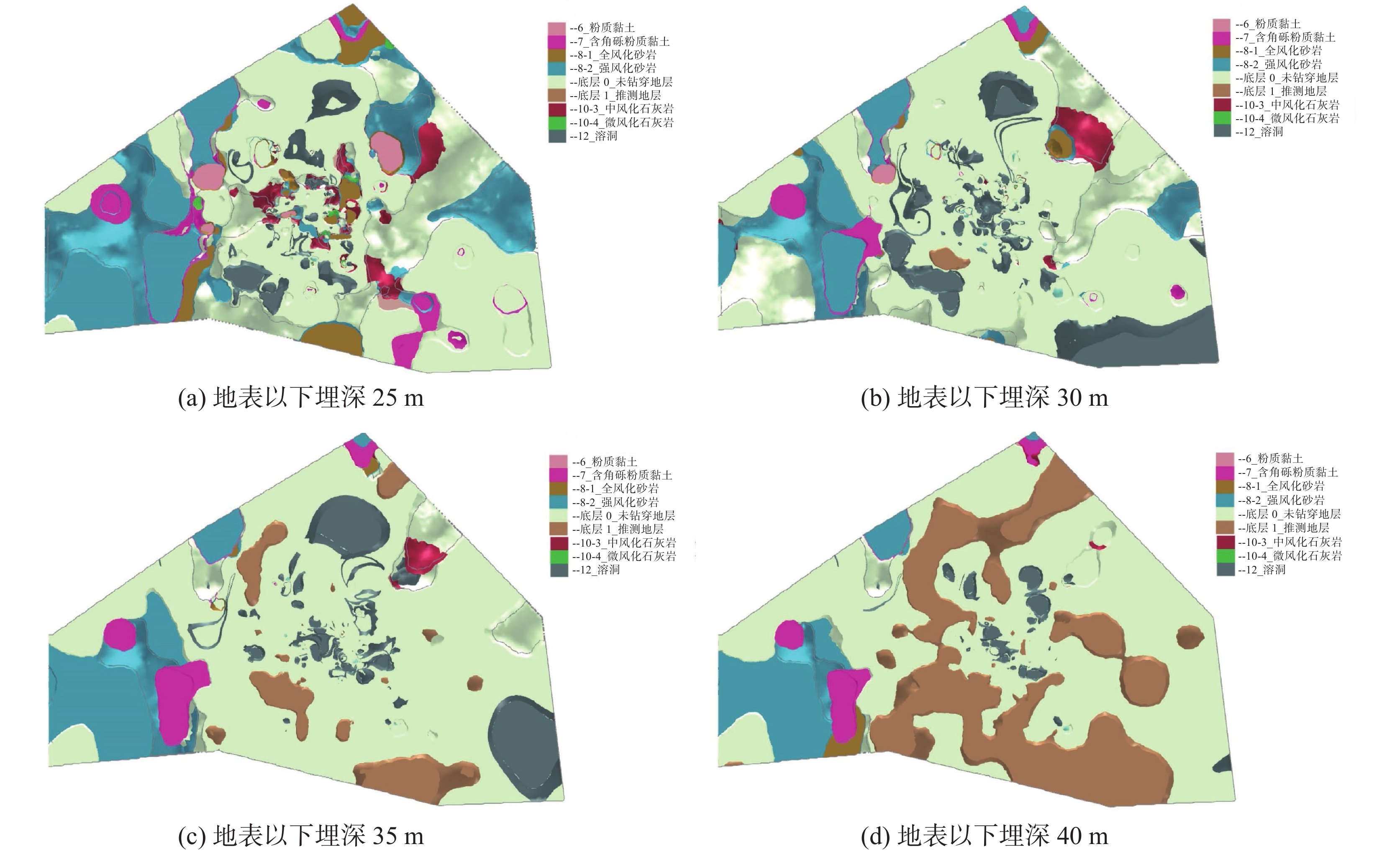
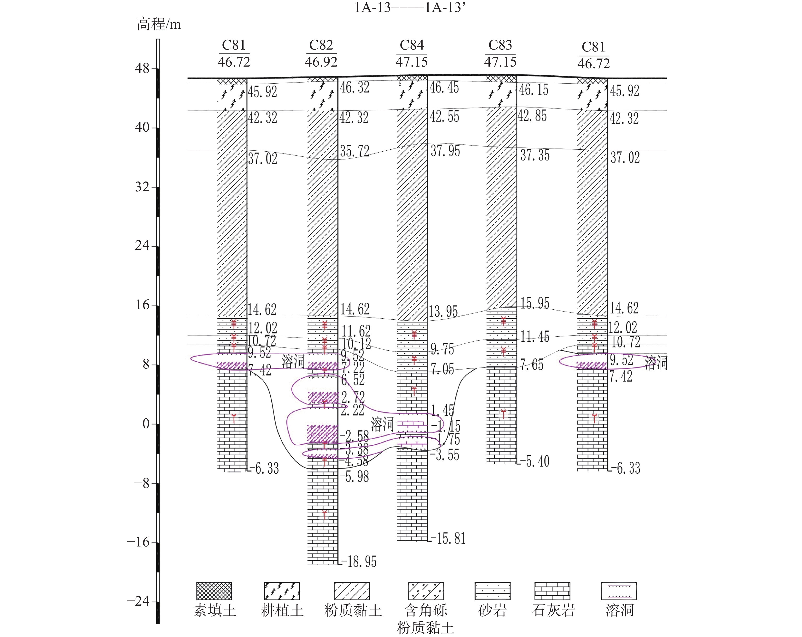
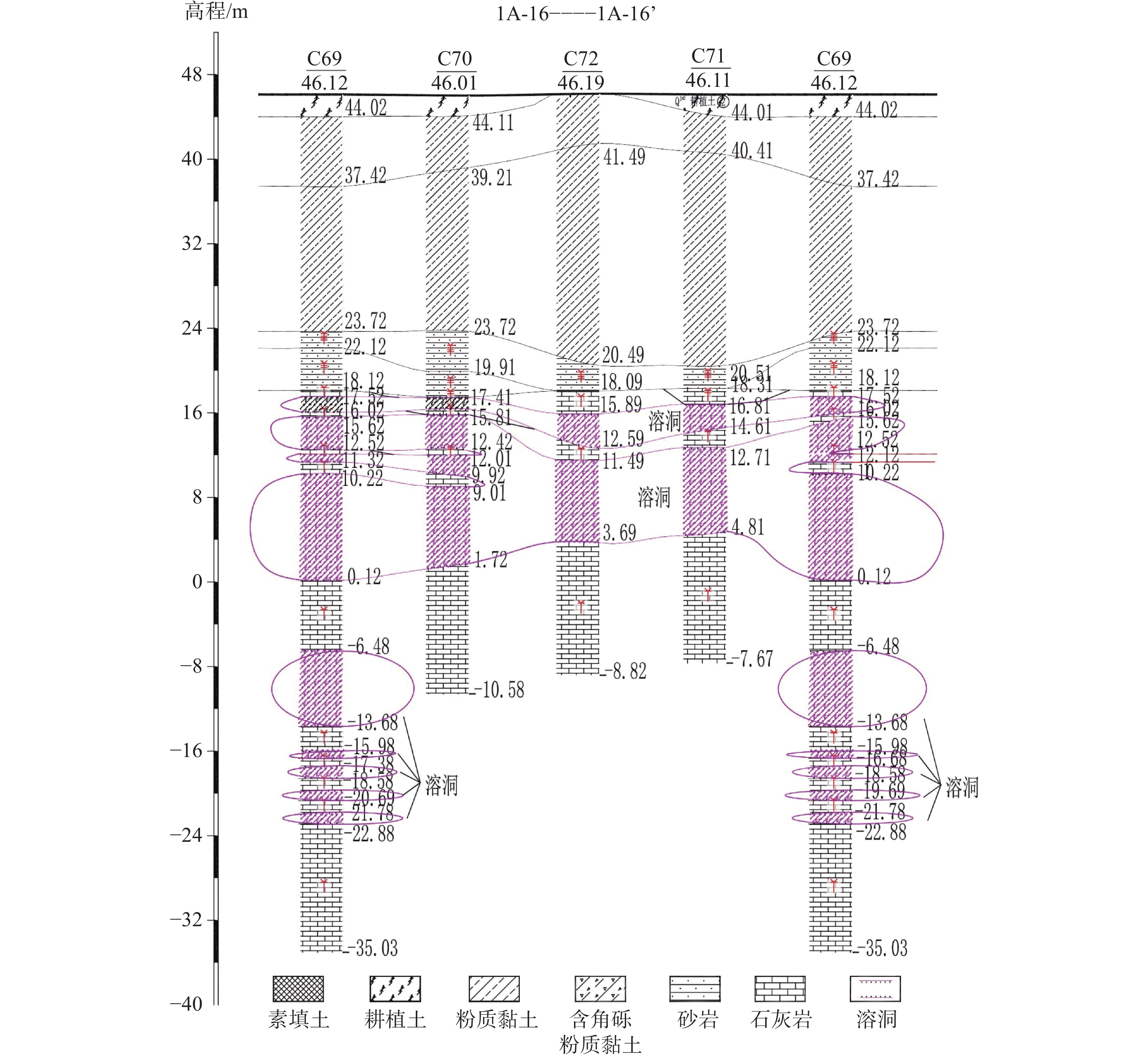
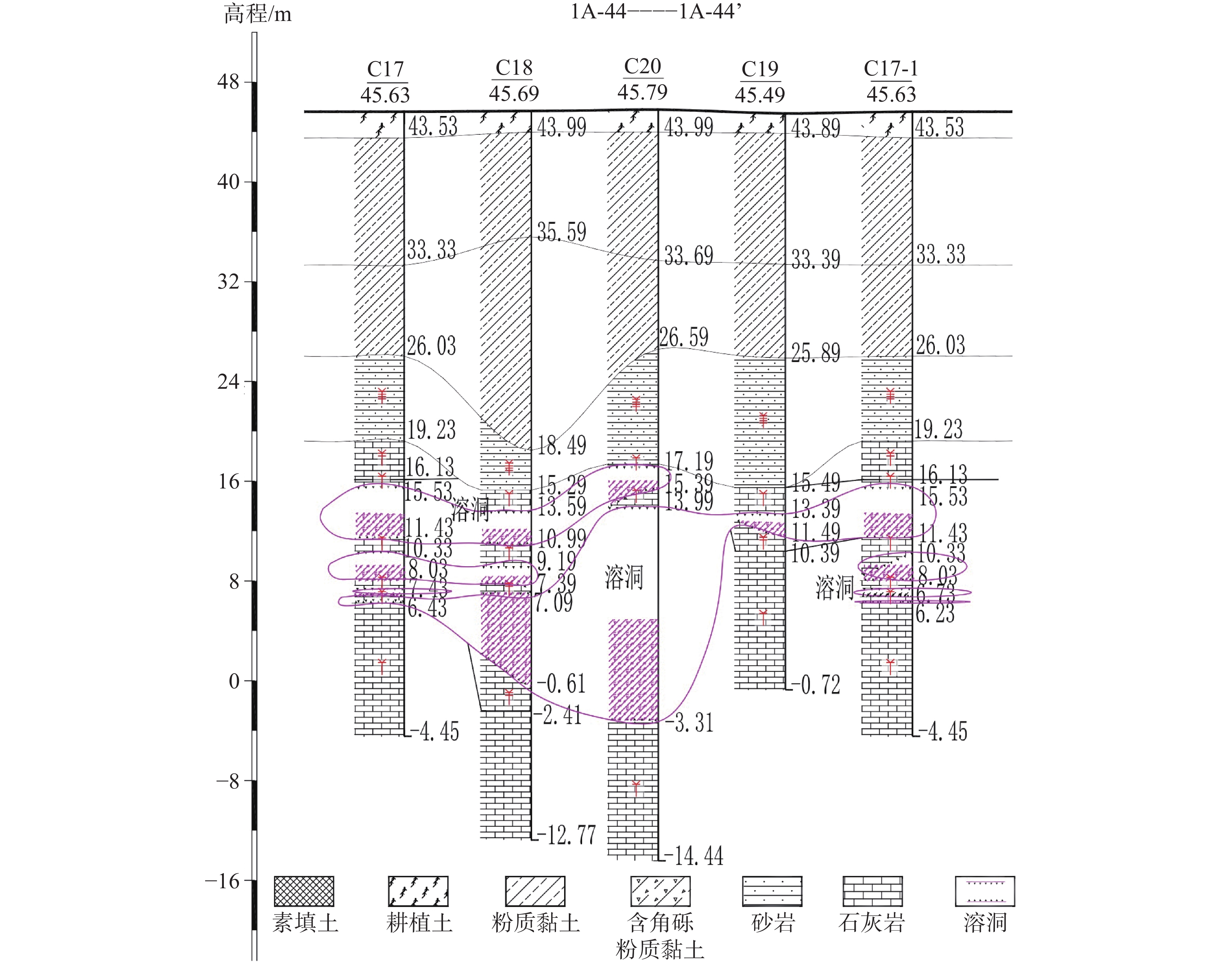
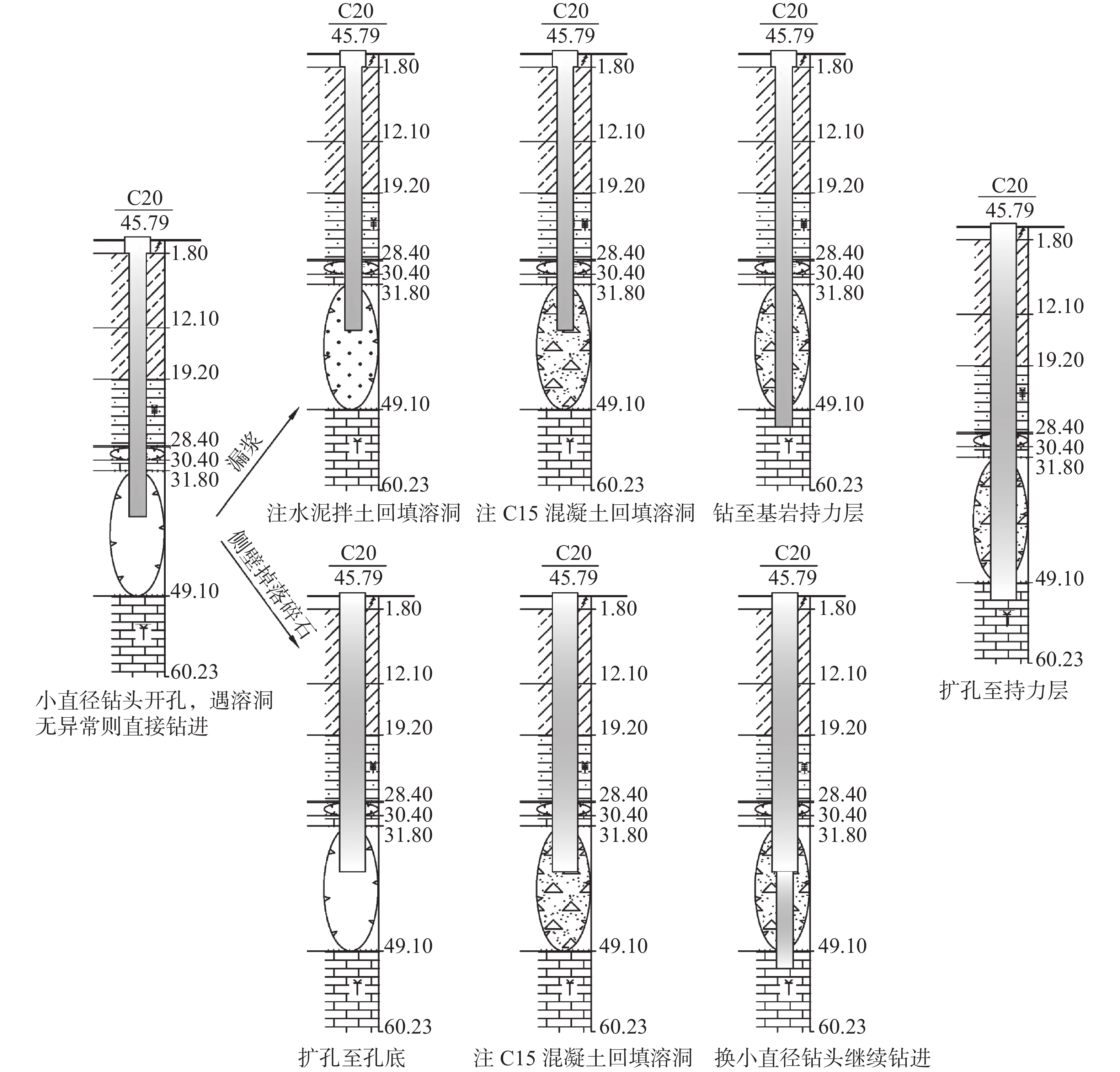
The geological structure of Shenzhen is complex, characterized by fault structures and regional erosion, which have led to significant karst development. Karst is roughly distributed in a northeast-trending, strip-like pattern. The study area is located at the Ecological Intelligence Valley Headquarters Base, part of the Dayun Shenzhen-Hong Kong International Science and Education City in Longgang district, Shenzhen. This area comprises multiple towers, their podiums, and basements, with a maximum building height of 188 meters. The building includes 41 floors above ground and two underground floors, and represents the primary zone with karst development. According to survey and drilling data, the geological strata in the study area are mainly composed of the Quaternary (Q) soil layer and the rock layer of lower Carboniferous Water Measurement Formation (C1c). A total of 399 boreholes were drilled on site, including 250 boreholes exposing soluble limestone layers and 173 boreholes exposing karst caves. The porosity rate of these boreholes is 69.2%, and the linear karst rate is 26.5%, indicating a region with intense karst development. To further investigate the impact of karst development on pile foundation construction, this study utilized survey drilling data and addressed the challenges posed by karst caves during on-site pile foundation construction along with their corresponding solutions. A detailed description of the karst development patterns and spatial distribution characteristics of the study area site was conducted, and the principles of karst cave treatment and related construction measures were summarized. The results showed that, (1) The underground karst space in the study area exhibits a complex morphology, mainly characterized by dissolution fissures, dissolution channels, and dissolution troughs. Dissolution fissures along the bedding planes and joint directions are relatively well developed. About 34% of the boreholes revealed more than three karst caves, and about 83.6% of the karst caves were less than five meters in height, with an average height of 3.03 m. The vertical development of karst caves is dense, with mainly small- and medium-sized caves being the predominant types. (2) The karst caves in the study area are mainly filled, followed by semi-filled caves. The filling materials primarily consist of silty clay containing angular gravel and sandy clay. The average burial depth of the cave roofs is 32.2 m, with an average roof thickness of 2.2 m. The limestone burial depth is relatively large, belonging to a deep covered karst area. (3) The development characteristics of karst in the study area are mainly controlled by factors such as lithology, geological structure, and hydrogeological conditions. The karst exhibits distinct vertical layering, with its development occurring at depths of 25 m to 80 m below the surface. The zone of strong karst development is mainly between 25 m and 40 m in depth. Due to the intense development of shallow karst, caves cannot be avoided, and the thickness of the cave roof is thin, resulting in insufficient bearing capacity. Therefore, pile foundation construction must cross the strongly developed zone of shallow karst to reach the stable bearing layer of limestone. (4) To address the complex development of karst caves in the study area, a combination of drilled pile foundations and raft foundations was employed in building foundation, with limestone serving as the bearing layer. The pile foundation treatment involves an "advanced grouting pretreatment plus artificial wall formation using cement mixed with soil or C15 concrete" approach to stabilize the karst caves. This method has yielded favorable results during actual construction process, with all core drilling tests of the foundation piles classified as Class I piles, ensuring construction quality while also reducing costs.
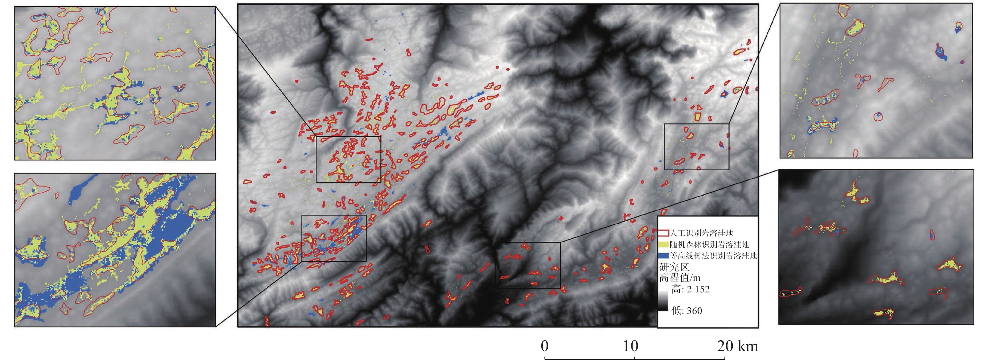
Intelligent identification method for karst depressions in railway construction areas: A case study of Enshi area, Hubei Province
YU Xianyu, WAN Zhe, ZHANG Kaixiang
2026, 45(1): 221-238. doi: 10.11932/karst20260112
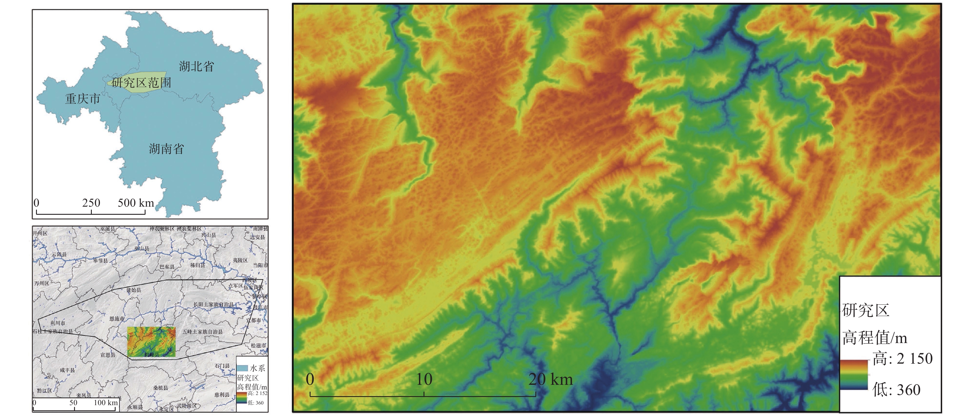
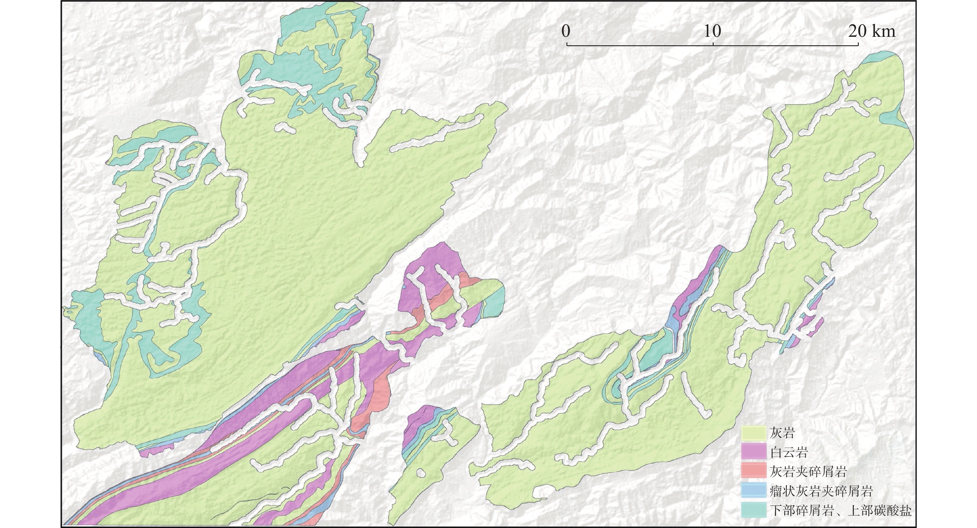
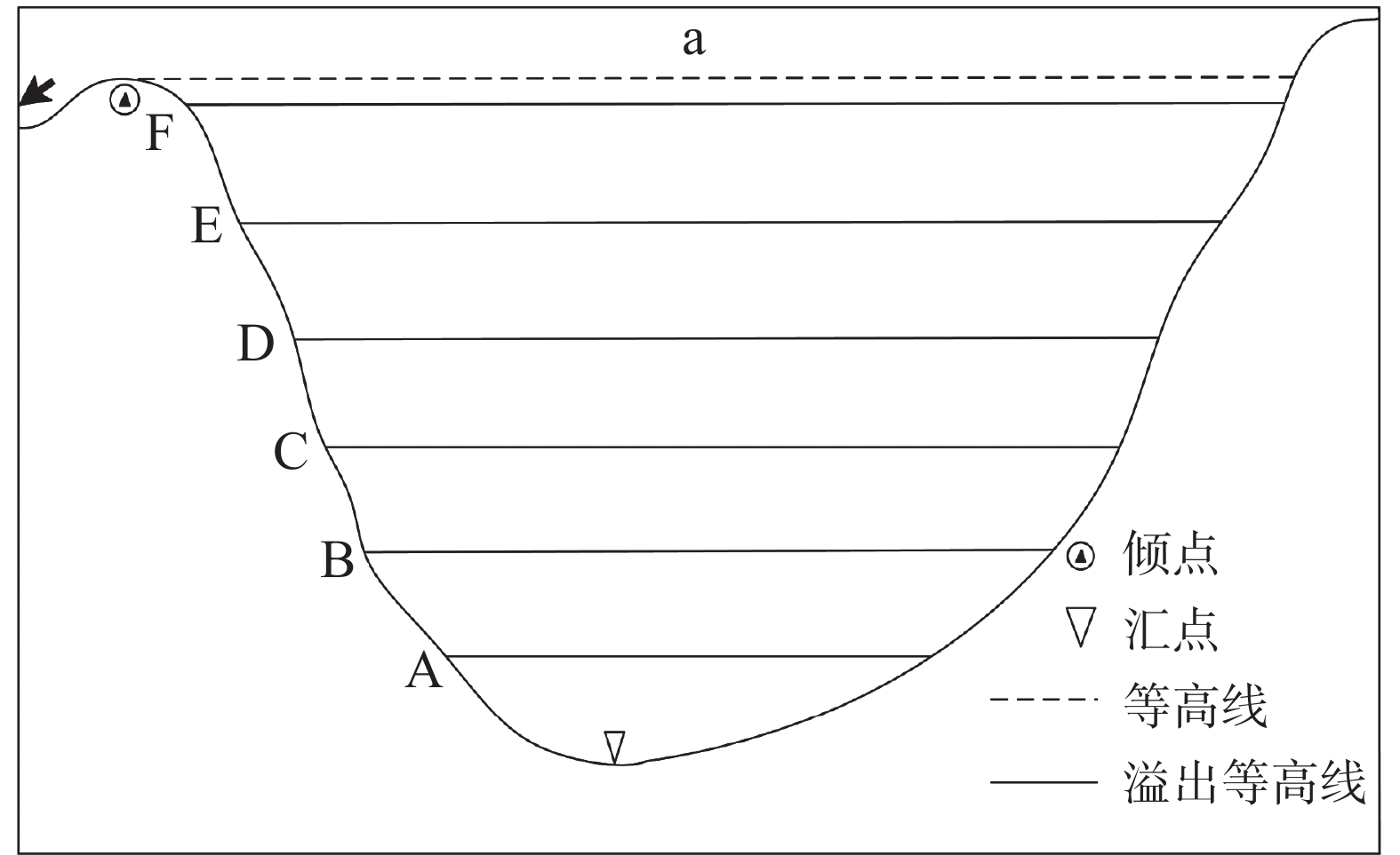
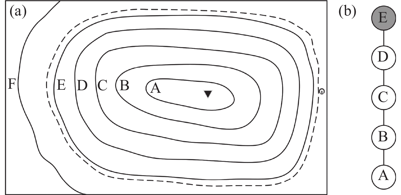
Abstract:
The karst geological environment in Enshi is complex, and the extensive development of karst depressions poses significant challenges to railway route planning, construction safety, and cost control. To address these challenges, this study focuses on the southern section of the route selection area of Yichang-Fuling Railway as the core research zone to systematically explore intelligent identification methods for karst depressions. The primary objective is to identify the optimal detection sheme that meets the practical requirements of railway engineering surveys, thereby providing reliable technical support for risk assessment and decision-making during the route selection phase. The study area is located at the northeastern edge of the Yunnan-Guizhou Plateau, and tectonically belonging to the fold belt in the Bamian Mountain Platform of the upper Yangtze Platform. This region features complete exposure of strata, encompassing marine sedimentary sequences from the Cambrian to the middle Triassic Periods,with lithological associations dominated by clastic and carbonate formations. These geological conditions provide a solid material foundation for the development and evolution of karst depressions.In this study, the geology-informed local contour tree method was adopted. Firstly, based on high-precision river system data, a 500 m river buffer zone was established to exclude non-karst areas affected by surface runoff. Meanwhile, the distribution of soluble rocks was accurately extracted from the regional stratigraphic and lithological database, eliminating the interference caused by similar terrain in non-soluble rock areas. Secondly, regional watershed boundaries were delineated through hydrological analysis and calculations, providing a basis for defining the spatial content of potential karst depression development. Finally, by overlaying the river system influence zone, soluble rock distribution, and watershed boundaries, the areas within the river buffer zone were excluded, and the core areas meeting the geological conditions for karst development were retained to generate DEM data of karst-prone regions. This approach effectively reduces the interference caused by non-karst landform features.To scientifically and comprehensively evaluate the identification performance, this study selects classic statistical indicators-accuracy and F-measure-to reflect the overall effectiveness of the method. Addditionally, the concept of deviation regression accuracy (D-value) is introduced to meet the stringent requirements of practical engineering for quantitative precision, as traditional indicators often fail to capture the spatial deviation between identified results and actual karst depressions. Experimental results show that supported by 30 m resolution DEM data, the geology-informed local contour tree method achieves optimal identification performance when the contour interval is set to 60 m and the minimum identified area threshold is 7,500 m2: The accuracy reaches 66.04%, the F-measure is 63.29%, and the D-value is as high as 88.68%. This results indicate that the method can not only effectively identify karst depressions, but also minimize spatial deviations to the greatest extent.To verify the method's applicability to data sources with different resolutions, parallel experiments were conducted on 12.5 m resolution DEM data following the same technical workflow. The results confirm that the method exhibits excellent adaptability and stability across varying resolutions, demonstrating a consistent pattern: For a fixed contour interval, as the minimum area threshold gradually increases, the D-value rises steadily before stabilizing. When the D-value reaches this stable phase, the corresponding parameters are determined as the optimal identification settings-further increasing the minimum area threshold will lead to the misclassification and exclusion of numerous actual karst depressions, thereby failing to meet practical engineering requirements. This finding provides clear guidance for parameter configuration across different data source scenarios, enhancing the method's utility in engineering projects with limited data resources. To further validate the proposed method's superiority, a comparative experiment was conducted using the random forest machine learning model, a widely adopted algorithm in geospatial identification. The results show that the random forest model achieves its best performance when the susceptibility index threshold is set to 95%. However, due to its over-reliance on statistical correlations rather than geological mechanisms, it tends to generate a large number of false positives in non-karst depression areas. Consequently, its accuracy, F-measure, and deviation regression accuracy are only 6.21%, 11.63%, and 44.34%, respectively-far lower than the 66.15%, 62.39%, and 88.33% achieved by the local contour tree method.In conclusion, the geology-informed local contour tree method demonstrates greater accuracy, reliability, and engineering applicability in identifying karst depressions compared to the random forest model. By integrating geological knowledge into the algorithm design, it effectively avoids false identifications caused by pure data-driven models and provides precise spatial information on karst depressions. This study not only enriches the technical system for intelligent karst identification, but also offers scientific and reliable technical support for railway route selection, risk assessment, and engineering construction in karst-prone areas. Therefore, it contributes to the improvement of construction safety and the reduction of engineering risks in complex geological environments.