• Included in CSCD
  • Chinese Core Journals
  • Included in WJCI Report
  • Included in Scopus, CA, DOAJ, EBSCO, JST
  • The Key Magazine of China Technology

Current Issue

2025 Vol. 44, No. 6

Display Method:
Numerical study on hydraulic failure characteristics of deep-buried solution-fissured limestone as an inrush prevention layer
ZHOU Fubiao, LIU Lei, MU Meng, LAO Jiarong, CHENG Xiaojie, MENG Yan
2025, 44(6): 1121-1133. doi: 10.11932/karst2025y018
Abstract:
In tunnel engineering in karst areas, the tunnel mud and water inrush is one of the most common geological disasters. These events significantly impact tunnel construction, safe operation, and the safety of personnel and equipment, particularly in tunnels with large burial depths located in water-rich karst areas. Numerous factors affect tunnel mud and water inrush, including tunnel burial depth, groundwater pressure, surrounding rock stress, and the characteristics of the water inrush prevention layer-such as its thickness, karstification rate, fissure density, and mechanical strength. The water inrush prevention layer refers to the rock mass situated between the tunnel and groundwater, serving as the critical barrier that prevents groundwater from rushing toward the tunnel free face. The strength of the rock mass in this inrush prevention layer determines its capacity to resist groundwater pressure. Key factors affecting its overall strength include the thickness, karstification rate, fissure density, and mechanical strength of the prevention layer. The development of solution-fissures within this rock mass reduces its effective thickness and structural integrity, thereby diminishing its ability to withstand groundwater inrush toward the tunnel free face.To investigate the impact of the development of solution fissures in the limestone inrush prevention layer on its failure characteristics under hydraulic action in deep tunnels, limestone samples were collected, and tests were conducted to determine the physical and mechanical parameters of rock. The true density, tensile strength, elastic modulus, Poisson’s ratio, cohesion, and internal friction angle of the limestone material were obtained. Four different models for water inrush prevention were designed with the use of finite difference numerical simulation software. These models are square-rectangular in shape, with cylindrical holes cut opposite each other in the middle of the upper and lower surfaces, but not completely through. The remaining middle layer forms a disc-shaped batholite that serves as the water inrush prevention layer. Shallow circular holes and strip-shaped grooves are cut on the upper surface of this disc-shaped water inrush prevention layer, representing the solution fissures developed within the water inrush prevention layer. The circular holes and strip-shaped grooves differ among the four models, representing varying karstification rates. Based on this, the models were assigned the measured physical and mechanical parameters. Numerical simulations of the model for inrush prevention batholitel were conducted under fixed geostress at a depth of 1,000 m, with gradually increasing water pressure at an interval of 50 m after constraining the bottom and surrounding areas of the model. The maximum shear stress and maximum shear strain increment of the model’s force response are used as the criteria to analyze the characteristics of each stage of the model’s force deformation and failure, as well as the stress-strain distribution contour maps. The similarities and differences among the four models were compared. The research findings show that:(1)The deep-buried solution-fissured limestone used as inrush prevention batholitel undergoes four stages of deformation and failure under high geostress and gradually increasing water pressure: elastic deformation, plastic deformation, residual strength, and failure.(2) The higher the karstification rate of the deep-buried limestone used as an inrush prevention batholite, the lower the critical water pressure required to cause hydraulic failure of this batholite. A relationship curve between the critical water pressure for failure of the inrush prevention batholite and the karstification rate has been established.(3) Under the effect of water pressure, the inrush prevention batholite without solution fissures is more susceptible to tensile failure near the upper surface, mixed tensile-shear failure around the lower surface, and tensile failure in the central area of the lower surface.(4) The development of solution fissures affects the distribution of stress and strain within the inrush-prevention batholite. Under the effect of water pressure, the inrush-prevention batholite with solution fissures is more prone to mixed tensile and shear failure at the edges and tips of the solution fissure zones, compressive shear failure at the periphery of the lower surface of the batholite, and tensile failure in the central area of the lower surface.(5) Tensile and shear deformations at multiple adjacent solution fissure tips tend to interconnect, forming a continuous tensile and shear fracture zone. Under water pressure, the inrush prevention batholite may experience tensile failure, tensile-shear failure, compressive-shear failure, or a combination of these failure modes, depending on the development of the solution fissures.The research findings offer valuable insights into the deformation and failure characteristics of hydraulic fracturing in deeply buried rock formations, aiding in the prevention of water inrush.
Hydrogeological processes of large karst spring in southeastern Yunnan affected by the combined influence of natural and engineering disturbances
HUANG Jingyu, LI Chunyu, XU Mo, WEI Qiyang
2025, 44(6): 1134-1143. doi: 10.11932/karst20250601
Abstract:
Large karst springs are important surface water resources and play a particularly significant role in the vast karst mountainous regions. In China, research on large karst springs has a long history with remarkable achievements, but it is predominantly concentrated in northern regions. However, studies on large karst springs in southern regions still remain insufficient and require deeper and broader investigation. In recent years, due to the frequent occurrence of extreme weather events and the intensified human engineering activities in southern karst areas, large karst springs have been faced with ecological and environmental challenges. Therefore, it is urgent to conduct scientific and targeted analyses of the hydrological processes of karst springs in south China under multifactorial disturbances.The eastern part of Yunnan is widely recognized as one of the most prominent and typical regions for environmental issues related to large karst springs in south China’s karst area. This study focuses on the Xiaolunan large karst spring in southeastern Yunnan. Persistent drought in the region, combined with tunnel dewatering within the spring area, has disrupted the discharge dynamics of the Xiaolunan karst spring, causing abnormal fluctuations. Based on hydrogeological investigations and regional hydrochemical and isotopic tests, this study identified the genetic characteristics of the spring, its recharge sources, and hydraulic connections with the tunnel project. Using synchronous monitoring data of precipitation, spring discharge, and tunnel borehole water levels, we analyzed their variation trends and correlations. Finally, a hierarchical groundwater flow system for the spring area was constructed to enhance understanding of the hydrological processes in large karst springs.The primary findings of this study are as follows: (1) The recharge area of the Xiaolunan large karst spring is located within the Honghe River Basin. During groundwater runoff, the water transitions from phreatic to confined conditions and eventually rises and discharges as a spring due to fault obstruction. After surfacing, the spring water flows downhill into the Pearl River Basin’s water system. Therefore, the Xiaolunan large karst spring is a fault-controlled uplifted spring with cross-basin recharge. The hydrogen and oxygen isotopes of the spring closely align with the atmospheric precipitation line, indicating that its recharge originates from atmospheric precipitation. Hydrochemical ion signatures show that tunnel construction drainage has impacted the hydrological processes of the large karst spring.(2) Precipitation in the spring area exhibits marked seasonality under the influence of the plateau monsoon climate. The borehole water level generally shows a downward trend, primarily caused by continuous dewatering from tunnel construction. Over a two-year period, under the combined influence of precipitation changes and tunnel disturbances, the discharge of the large karst spring remained stable. The time-series curves were categorized into two types: asymmetric sharp peaks characterized by steep rises and falls, and relatively gentle, wave-like undulations. The exhibited a weak correlation with precipitation, with a lag time of 1 to 2 months during certain periods.(3) Multiple crustal uplifts since the Neotectonic Movement have caused spatial shifts in the erosional datum within the spring area, which have sequentially evolved into the present-day local and regional flow systems. The impacts of tunnel construction have created an intermediate flow system within a specific part of the spring area. The combined synergistic effects of the intrinsic properties of the regional flow system and the local flow system maintain the dynamic balance of large karst spring discharge across different hydrological periods, while also reducing the spring’s sensitivity to precipitation events. The intermediate flow system induces groundwater capture and pressure relief in the karst aquifer, directly leading to a reduction in discharge from the large karst spring.Continuous drainage of static groundwater reserves from the aquifer by the tunnel will cause the drawdown cone to expand progressively, increasingly threatening spring discharge. To protect the water resources of the large karst spring, it is recommended that the tunnel construction strictly implement water sealing and discharge limitations. Grouting and sealing of excavated sections should be promptly carried out, with particular focus on outer lining gaps and sections containing concentrated runoff channels, to minimize groundwater extraction. During the tunnel’s operational period, borehole water levels and spring discharge should be continuously monitored, and their recovery dynamics should be consistently tracked.
Hydrochemical characteristics and genesis analysis of hot springs in the Changtan area, Chongqing
LIU Cao, XU Gaohai, LI Delong, LUO Fuheng, XU Haifeng, CHEN Cheng, ZOU Jianshu
2025, 44(6): 1144-1157. doi: 10.11932/karst20250602
Abstract:
This study takes the natural and artificially drilled hot springs as the research objects located in the northwest wing of the Fangdoushan anticline in Changtan Town, Wanzhou District, Chongqing City. It systematically examines their hydrochemical characteristics, heat storage conditions, and genetic mechanisms, revealing the unique formation process of the low-temperature Cl-Na type hot springs in the high-uplift anticline region. The hot springs in the study area are located within the carbonate rock layers of the Lower Triassic Jialingjiang Formation (T1j), and are controlled by the combined effect of the Fangdoushan anticline structure and local hydrogeological conditions. Through hydrogeochemical analysis, geothermal temperature scale calculations, and hydrogeological conceptual model analysis, the following key conclusions are drawn:1. Chemical characteristics and genesis of water(1) The chemical composition of the hot spring water is classified as Cl-Na type (according to the Piper three-line graph). The pH is weakly alkaline (7.26 to 7.87). The mineralization degree is significantly higher than the regional background level, TDS up to 11.25 g·L−1. The proportions of Cl and Na+ are 36.72% and 55.37%, respectively.(2) The high mineralization degree stems from the concentrated halogen dissolution and filtration in the tidal flat-lagoon facies strata of the Triassic Jialingjiang Formation (T1j), as well as the water-rock interactions during the deep circulation processes (such as dolomite dissolution and sodium growth petrification). Additionaly, sulfate reduction reactions involving microorganisms (e.g., H2S generation) and long-range migration (>10 km) further enhance ion enrichment.(3) The content of Sr2+ among the trace elements is notably high (37.06 mg·L−1), and its source is closely related to the water-rock interactions involving carbonate rocks and gelatinate layers in the Triassic Jialingjiang Formation (T1j).2. Heat storage conditions and circulation mechanism(1) The calculation of geothermal temperature scales (quartz, chalcedony, and quartzite) shows that the heat storage temperature ranges from 54 ℃ to 78 ℃, with an average of 65.4 ℃, classifying it as a low-temperature geothermal system. Based on the ground temperature gradient, the circulation depth is estimated to be approximately 2,000 meters.(2) The heat storage layer is composed of interbedded limestone and dolomite from the Triassic Jialingjiang Formation (T1j), which overlies the mudstone of the second section of the Badong Formation (T2b2), the clastic rocks of the Triassic Xujiahe Formation (T3xj), and the sand-mudstone of the Jurassic system. Together, these formations create a water-proof and heat-insulating cover layer, thereby forming a closed heat storage structure.3. Groundwater recharge sources and heat sources(1) Recharge sources: Atmospheric precipitation in the exposed area of the Triassic Jialingjiang Formation (T1j) at the core of the Fangdoushan anticline infiltrates in through karst fissures and sinkholes, generating deep runoff.(2) Runoff path: Groundwater migrates deeper along the fault-fracture system at the wing of the anticline, absorbs heat from the surrounding rock, and undergoes dissolution and filtration, with a retention time of several hundred years.(3) Heat source: There is no additional heat source, such as magmatic activity. The heat originates from the normal geothermal gradient (2.5 to 3.0 ℃·100 m−1), and the formation of the heat reservoir is driven by the warming of the stratum.4. Three-dimensional genesis conceptual model(1) After the infiltrating as atmospheric precipitation, the water migrates deeper along the fracture network at the core of the anticline. It undergoes long-path circulation (approximately 2,000 meters) and slow warming, accompanied by intense water-rock interaction with salt-bearing carbonate rocks. (2) Deep faults, such as the outer dam reverse fault, act as secondary hydrothermal channels that locally supplement solutes and heat; however, the main heat source remains the natural warming of the crust. (3) Hydrogeological sections reveal that the combination of an aquifer and impermeable layer under the control of anticline structures, is the key to the occurrence and migration of thermal fluids. The mudstone of the Triassic Badong Formation (T2b) effectively blocks vertical heat loss and maintains the stability of thermal reservoirs.
Field experiment on hydraulic channel sealing via grouting to prevent groundwater pollution in karst region
JI Zhihao, CHEN Shiwan, WU Jiaoji, YU Huiyun, WU Pan, MA Lanjian
2025, 44(6): 1158-1172. doi: 10.11932/karst2025y021
Abstract:
The karst regions in Southwest China are characterized by intense karstification, complex hydrogeological conditions, and well-developed karst conduits with pronounced spatial heterogeneity. These factors contribute to the inherent vulnerability of karst groundwater systems, rendering them highly susceptible to contamination. Additionally, large-scale mining activities in these areas generate substantial volumes of wastewater and waste materials, exacerbating groundwater pollution. Consequently, the development of scientific technologies for the prevention, control, and assessment of groundwater pollution is of significant importance. This study focuses on the Zimudang mining area in Guizhou Province, where curtain grouting experiments were conducted to seal identified karst conduits, targeting the dominant hydraulic pathways of groundwater contamination. Real-time, in-situ monitoring using electrical resistivity methods was employed throughout the grouting process to evaluate the effectiveness of the sealing measures.The Zimudang depression is a critical surface water convergence area within the study area, where the converging surface water is transformed into groundwater through the K20 drainage cave located beneath a steep cliff on the northeastern side of the depression. Mining activities have compromised the water-blocking function of the F1 fault, altering groundwater flow so that it converges toward the mined-out areas and mining tunnels. Within the mining area, the K20 drainage cave serves as a channel for the concentrated recharge of groundwater from atmospheric precipitation. Upon entering the K20 drainage cave, the principal karst hydraulic conduits extend roughly in an east–west direction. Taking into account the characteristics of subterranean river channels, topography, and surface structures, the site for the curtain grouting test was selected in the northern part of the tailings pond. Drilling and borehole TV surveys were conducted at the site. Analysis of core logs and borehole TV results confirmed significant karst development in the underlying strata, which serve as the dominant hydraulic pathways for groundwater contamination migration, thereby validating the suitability of the test site. To ensure that the grout solution thoroughly permeated and filled fractures and karst caves, high-pressure intermittent grouting was adopted. The grouting was performed sequentially from ZJ08 to ZJ01, followed by a second round after the injected grout had cooled. Throughout the entire grouting process, high-density resistivity and transient electromagnetic methods were employed to monitor changes in formation resistivity. In this experiment, one high-density electrical measurement line and 11 transient electromagnetic measurement lines were deployed. Three electrode configurations-Wenner, dipole, and Schlumberger-were utilized, with measurement depths of 15 m, 15 m, and 17 m, respectively. All three configurations demonstrated a clear increase in formation resistivity within the grouted zone, with the low-resistivity regions adjacent to the boreholes exhibiting more pronounced improvements after grouting. For instance, among the transient electromagnetic measurement survey lines (S3, S5, S7, S8, S10, and S11), significant increases in formation resistivity were observed in lines S3, S5, S7, and S8, indicating effective grouting and sealing. In contrast, lines S10 and S11 showed either negligible changes or a decrease in resistivity after grouting. This discrepancy is attributed to the fact that line S10 was situated beyond the grouting influence zone due to its distance from the grouting wells, while line S11 exhibited localized resistivity reductions, likely caused by the displacement of water from karst caves and fractures as grout infiltrated these features. Analysis of the geophysical monitoring data revealed that when survey line layouts are constrained by factors such as topography, the high-density electrical method is more suitable for detecting shallow resistivity variations in areas with limited terrain, whereas the transient electromagnetic method is more effective for probing deeper subsurface electrical properties.To quantitatively assess the grouting effectiveness, formation porosity was derived from resistivity measurements using Archie’s formula. By comparing porosity variations before and after grouting, the grout diffusion area was delineated, and the effectiveness of blocking groundwater pollution pathways was evaluated. For instance, in measurement lines S3, S5, S7, and S8, the grout diffusion area within a 2-meter radius of the grouting wells ranged from 21.42 m2 to 99.32 m2. The maximum reduction in formation porosity reached 65.7%, averaging 39.9%. This study demonstrates that electrical resistivity monitoring enables real-time, in-situ evaluation of the grouting sealing effectiveness in karst conduits. In addition, by converting resistivity data into formation porosity for quantitative analysis, it is possible to accurately delineate the grouting diffusion area and sealing range, thereby assessing whether key hydraulic pathways have been effectively sealed. This approach provides robust technical support for evaluating the performance of curtain grouting in blocking the dominant groundwater contamination pathways in karst regions.
Influencing factors and formation mechanism of covered karst collapse in Liujiazhuang, Qufu City
GUO Yaohua, KANG Fengxin, FENG Yawei, QIN Peng, WU Wei, LI Jialong, CUI Yang, SUI Haibo, ZHENG Tingting, LIU Xiaotian
2025, 44(6): 1173-1185, 1197. doi: 10.11932/karst2025y009
Abstract:
By the end of 2019, four karst collapses had occurred in Liujiazhuang village, Qufu City, resulting in seven collapse points that caused damage to houses and farmland, ultimately leading to the relocation of the entire village. To investigate the influencing factors and formation mechanism of karst collapse in Liujiazhuang village, Qufu City, a comprehensive study was conducted, including ground surveys of karst collapses, geophysical exploration, hydrogeological drilling, geotechnical tests, and dynamic monitoring of karst groundwater levels. The study systematically examined the degree of karst development, thickness, structure, and physical and mechanical properties of the overlying soil layer, as well as the dynamic characteristics of karst groundwater. The results show that karst collapse is influenced by fault structures. Rocks in the fault structures and their influencing zones are fractured, and groundwater dissolution is intensified, facilitating the formation of dissolved pores and karst caves. The collapse points are located near the faults and their secondary faults. Karst development in the shallow layer is intense and can be categorized into strongly developed, moderately developed, and generally developed karst fissure zones. The collapse points are located within a well-developed karst fissure zone. The overlying soil layer is composed of low-cohesion sand and soil with higher cohesion. The soil layer structure can be divided into single-layer, double-layer, and multi-layer structures, with collapses mainly occurring in the double-layer soil structure. The thickness of the overlying soil layer varies significantly, ranging from 35 to 45 meters at the collapse points. The annual variation of the water level can be divided into three stages: wet season, normal water season, and dry season. Collapses mainly occur when the karst water level drops rapidly and significantly during the agricultural irrigation period and when the karst water level rises sharply to the rock-soil interface after concentrated rainfall. The groundwater dynamic model is categorized into confined-unconfined fluctuation and confined fluctuation periods. Collapses occur during the confined-unconfined fluctuation period of the karst water level. The formation mechanisms of karst collapse vary depending on the structure of the overlying soil layers. In the single-layer structure mode, collapses are primarily caused by piping. Their formation and evolution process can be summarized as follows: karst water level drop→soil particle loss→soil cave formation, development, and expansion→soil cave roof instability→karst collapse. In the double-layer structure mode, collapses are mainly caused by negative pressure suction, seepage piping, and load softening. The formation and evolution process can be summarized as follows: karst water level drop→negative pressure suction→soil peeling→soil cave formation→rainfall infiltration→seepage piping→soil cave development and expansion→load softening→soil cave roof instability→karst collapse.
Genesis and karst characteristics of marble agglomerate in volcanic rocks on the eastern slope of Wutong Mountain, Shenzhen
WANG Xiaohu, WANG Ping, WANG Xianneng, LAI Anfeng
2025, 44(6): 1186-1197. doi: 10.11932/karst20250603
Abstract:
Karst phenomena, such as fissures and caves, occur in the marble agglomerate of pyroclastic rocks on the eastern slope of Shenzhen’s Wutong Mountain. These features have affected the engineering projects such as subway construction and pile foundation engineering in the study area. This study collected numerous borehole histograms and data on multi-phase geological surveys from the Wutong Mountain area, interpreted volcanic structures using airborne LiDAR data from the middle and eastern parts of Wutong Mountain, and conducted engineering geological ground surveys in the study area. The study shows: (1) Marble agglomerate volcanic rocks on the eastern slope of Wutong Mountain are distributed in the explosive collapse phase rocks of the second eruptive cycle of Wutong Mountain’s volcanic activity. It is inferred that the karst area within these volcanic rocks is located in the Wangjihu–Xiao’ao volcanic structural depression, covering total area of about 1.826 km2. (2) It is further inferred that the marble agglomerate in the volcanic rock, originated from the limestone in the lower Carboniferous Shidengzi Formation (C1s) within the volcanic channel, formed during early intense eruptions. Prior to the volcanic eruption, magma compression and gas explosions caused the surrounding rock to fracture and collapse. During the volcanic eruption, the release of magma pressure propelled the fragmented and collapsed surrounding rock material to the surface, where it mingled with magma and solidified into the volcanic rock. (3) Due to the favorable groundwater circulation and alternating conditions in the study area, the marble agglomerates have undergone erosion, resulting in karst morphology primarily characterized by small and medium-sized caves. The connectivity between these caves is poor, and the degree of karst development ranges from weak to moderate. (4) The development of karst is influenced by fault structures, depth, topographic features, and the degree of weathering, exhibiting strong zoning and heterogeneity. Karst development pronounced in the NE direction, followed by the EW and NW directions, which aligns with the main orientations of regional faults. Karst is more developed in sections with burial depths of 10 to 20 m and 50 to 60 m, and at elevations of 30 to 40 m and 50 to 60 m. Karst development is stronger in valley areas and weaker on hillside. It is most developed in strongly to moderately weathered zones, followed by the residual soil to completely weathered zones, while karst development is weak in slightly weathered area. This study innovatively analyzes the formation of marble agglomerations based on the history of volcanic eruption. Through DEM data interpretation, Wutong Mountain is shown to have evolved from early "central eruption + peripheral multi-point eruption" phase to a later "central eruption" phase. It is inferred that early intense eruptions formed marble-bearing agglomerated volcanic rocks. Due to the weakening of eruption intensity and the lengthening of eruption path during the middle and late stages, the limestone blocks failed to integrate into the volcanic rock mass. Most of Wutong Mountain’s large block-bearing volcanic rocks were subsequently covered by later eruption materials, while the eastern periphery was exposed or shallowly buried due to fewer eruption events, providing favorable conditions for the subsequent dissolution of marble agglomerations. The research findings will provide a foundation for the prevention and control of karst environmental geology and engineering geological problems in the volcanic rock area of Wutong Mountain as well as provide a reference for karst research in similar volcanic rock areas.
Variation characteristics and paleoclimatic/environmental implications of Mg/Ca, Sr/Ca, and Ba/Ca ratios in endogenic travertine from Baishuitai, Yunnan Province
GAN Hailing, XU Hongyang, ZHAO Xi, ZHOU Limin, ZHENG Xiangmin
2025, 44(6): 1198-1211. doi: 10.11932/karst20250604
Abstract:
Reconstructing high-resolution paleoclimate and environmental records is of great significance for deepening our understanding of the mechanisms driving global climate change and for predicting future climate trends. As a typical supergene sediment, travertine serves as an ideal geological archive for studying paleoclimate change at inter-annual to decadal scales due to its high sensitivity to climatic and environmental changes, rapid deposition rates, and widespread distribution. Previous real-time monitoring of trace elements by our research group in Baishuitai spring water over several years revealed that the concentrations of elements such as Mg, Sr, and Ba in the local spring water can reflect changes in local precipitation. However, it remains unclear whether variations in Mg, Sr, and Ba within the travertine itself can inherit the signals of these element variations observed in the spring water. This uncertainty limits the use of Mg, Sr, and Ba in travertine for paleoclimatic and environmental reconstruction. To further elucidate the climatic and environmental significance of Ca, Mg, Sr, Ba, and their ratios (Mg/Ca, Sr/Ca, Ba/Ca) in the endogenic travertine at Baishuitai, Yunnan Province, Southwest China, this study analyzed the concentrations of these elements and their ratios in both modern newly-formed travertine (May 2018 to October 2022, monthly resolution) and a modern travertine profile (from 2001 to 2016, semiannual resolution) from the Baishuitai area. The results show that:(1) Spring water is the primary source of Mg, Sr, and Ba in the Baishuitai travertine, while local precipitation and soil material carried by the overland flow serve as seasonal sources.(2) The peaks and troughs in the Mg/Ca, Sr/Ca, and Ba/Ca ratios of the modern newly-formed travertine correspond closely with those in the spring water during the same period, demonstrating strong consistency. This indicates that the variations in the Mg/Ca, Sr/Ca, and Ba/Ca ratios within the travertine primarily inherit the variations of these ratios in the spring water. Since changes in the Mg/Ca, Sr/Ca, and Ba/Ca ratios in the spring water mainly indicate variations in precipitation, the changes in these ratios in the travertine also primarily reflect precipitation fluctuations. Additionally, it was found that the distribution coefficients of Mg, Sr, and Ba between the spring water and modern newly-formed travertine show significant positive correlations with temperature (Mg: r = 0.45, p = 0.0007; Sr: r=0.42, p=0.002; Ba: r=0.43, p=0.0012), indicating that temperature is also an important factor influencing the Mg/Ca, Sr/Ca, and Ba/Ca ratios in the travertine. Furthermore, the Ba/Ca ratio in the travertine exhibits a significant positive correlation with the content of residue (r=0.3, p=0.041), suggesting that the Ba/Ca ratio is also affected by soil material input from the overland flow.(3) On an inter-annual scale, the Mg/Ca ratio in the white travertine layers shows a significant negative correlation with annual precipitation (r=-0.53, p=0.035), indicating that the Mg/Ca ratio in these white layers likely reflects changes in local precipitation. Concurrently, the Mg/Ca ratio in the dark travertine layers shows significant negative correlations with annual precipitation (Lijiang, no lag: r=-0.33, p=0.041; Lijiang, 1-year lag: r=-0.46, p=0.025; Shangri-La, 1-year lag: r=-0.42, p=0.045) and significant positive correlations with mean rainy season temperature (Lijiang: r=0.39, p=0.032; Shangri-La: r=0.42, p=0.033). This suggests that the Mg/Ca ratio in the dark layers likely reflects the combined influence of local precipitation and temperature. Additionally, the Sr/Ca ratio in the dark travertine layers shows a significant positive correlation with layer thickness (r=0.59, p=0.036), indicating that the Sr/Ca ratio may reflect changes in the travertine deposition rate.In summary, these findings provide an important scientific basis for utilizing geochemical indicators in travertine to reconstruct past high-resolution climate and environmental conditions.
Genetic mechanism and comparative significance of the "double-dome structure" of the Baimadong-Xiaodong Cave System in Gulin county
ZHOU Wenlong, ZHAO Shiqi, MO Guifen, TAN Ming
2025, 44(6): 1212-1224. doi: 10.11932/karst20250605
Abstract:
Since the concept of the "double-dome structure" was first proposed following its discovery in the Ziyun Miaoting Chamber of Guizhou in 2021, no similar structures had been reported in other karst caves, leading to its initial classification as a unique occurrence. This perception changed when a suspected "double-dome structure" was identified in the Baimadong Cave-Xiaodong Cave System in Gulin county, Sichuan. This new finding provides an excellent opportunity for comparative analysis, significantly advancing the scientific understanding of this distinctive speleological form. The Baimadong Cave-Xiaodong Cave System is situated in a mountainous valley along the periphery of a polje, on the northern side of the western segment of the Dalou Mountains fold belt within the Wumeng Mountain system: a transitional zone between the Sichuan Basin and the Yunnan-Guizhou Plateau. The area features pronounced topographic relief and a well-developed hydrological network. The Baishahe River flows underground at the entrance of Xiaodong Cave, travels approximately 1.2 km in a southwestern direction, and reemerges at the exit of Xiaodong Cave, with a hydraulic gradient of 5.5%. It eventually converges with the Bajiaogou River near Baishachang Town and discharges into the Chishuihe River. Geotectonically, the region lies between the Sichuan-Yunnan and Sichuan-Guizhou meridional structural zones, bordered to the north by the Sichuan Basin-a first-order subsidence zone of the Cathaysian structural system-and adjacent to the "Central Guizhou Uplift" along the northern edge of the complex east-west trending Nanling structural belt to the south. The area widely exposes strata ranging from the Cambrian to the Cretaceous, with the Devonian and Carboniferous systems absent. The exposed formations primarily consist of carbonate rocks such as dolomite and limestone, along with sandstone, shale, and Jurassic purple sandy shale, providing favorable conditions for karst development. The Baimadong Cave-Xiaodong Cave System has developed in mid- to thick-bedded limestone of the lower Permian Maokou Formation (P1m), which is 151 to 337 m thick and offers excellent conditions for cave formation. This study combines field surveys to document dissolution features with terrestrial laser scanning to conduct precise, georeferenced 3D mapping of the cave system. Point cloud slicing techniques were applied to deconstruct the spatial data, with a focus on the suspected "double-dome structure", to analyze its morphological characteristics and genetic mechanisms. Through comparison with the Ziyun Miaoting Chamber, we aim to generalize a universal genetic model for the "double-dome structure" and to systematically examine the developmental drivers of the Baimadong-Xiaodong Cave System, thereby enhancing the understanding of the evolution and geomorphic impact of subterranean chambers. The main conclusions are as follows.(1) Three-dimensional morphological analysis confirms that the structure in the Baimadong-Xiaodong Cave System is consistent with the scientific concept of a "double-dome structure" proposed in 2021, demonstrating that such structures are not unique in karst environments.(2) The development of the "double-dome structure" is horizontally controlled by multiple sets of multi-phase joints with varying orientations and spacing, where dense joint systems play a critical role in forming internal polygonal patterns. Vertically, the structure reflects the combined effects of tectonic uplift and fluvial incision, modified by multi-phase water flow. Its position on the flank of an anticline facilitates the opening of basal fractures, promoting groundwater infiltration. The mid- to thick-bedded, massive limestone of the Maokou Formation provides the necessary lithological conditions for stress-induced collapse and long-term stability.(3) The development of the Baimadong-Xiaodong Cave System is closely linked to its regional geological and hydrological setting. The traverse of the Baishahe River creates a steep hydraulic gradient across the cave, while abundant rainfall and a large catchment area provide sustained hydrodynamic forcing, serving as the primary agent for speleogenesis. The competent limestone of the Maokou Formation offers a suitable material basis for the development of extensive cave passages and significant vertical relief. The presence of tiered cave levels reflects neotectonic uplift, and well-developed faults and folds have contributed to the structural complexity of the system.(4) A spiral structure within the cave records a shift in the flow path of the Baisha underground river between the upper and lower levels, indicating at least two distinct phases of water flow: an early phase from the Xiaodong Cave entrance toward Baimadong Cave, followed by a later phase developing downward from the Xiaodong Cave entrance to its exit.(5) Comparative analysis with the Ziyun Miaoting Chamber reveals consistent developmental patterns for "double-dome structure". They typically form in intensely jointed zones at the hinge-limb transition of folds, at specific depths below the surface, preferably in mid- to thick-bedded, massive limestone. This lithology provides a balance between collapse potential and structural stability. Their formation is controlled by tectonic uplift and river incision, and they commonly undergo modification through multi-phase water flow.
Characteristics and influencing factors of carbon, nitrogen, and phosphorus nutrients in the soil-plant-litter continuum of typical communities in mid-high mountain karst areas
SHI Jialiang, TAO Lanchu, LUO Ping, HE Siteng, ZHAN Fangdong
2025, 44(6): 1225-1240. doi: 10.11932/karst20250606
Abstract:
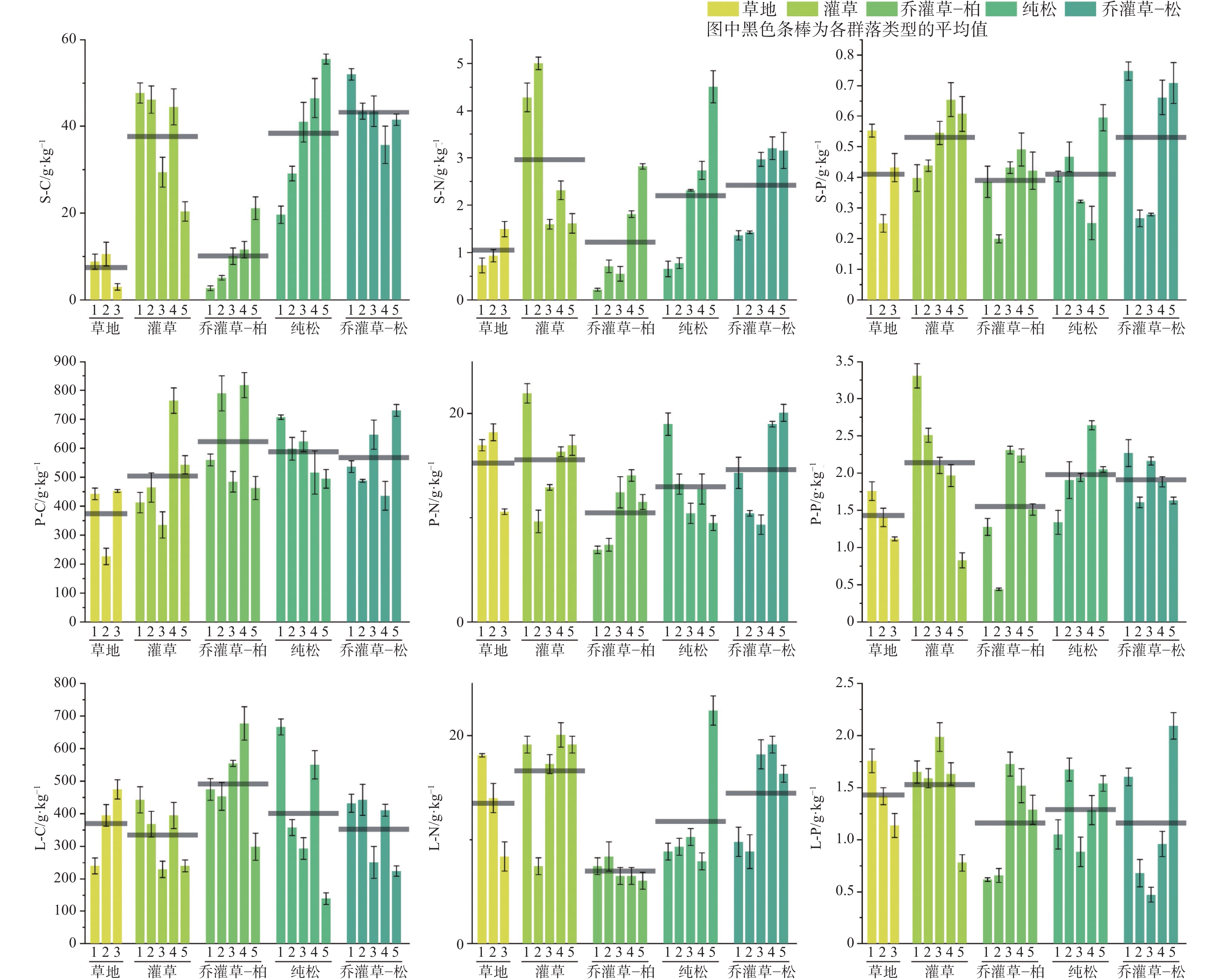
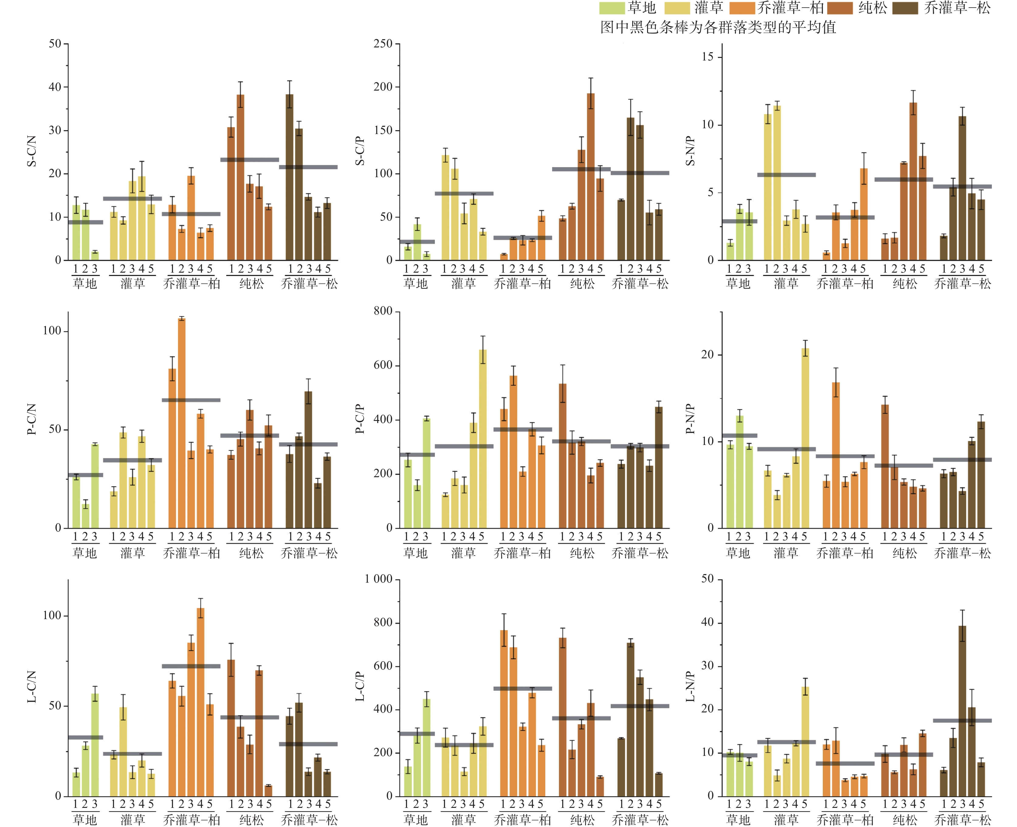
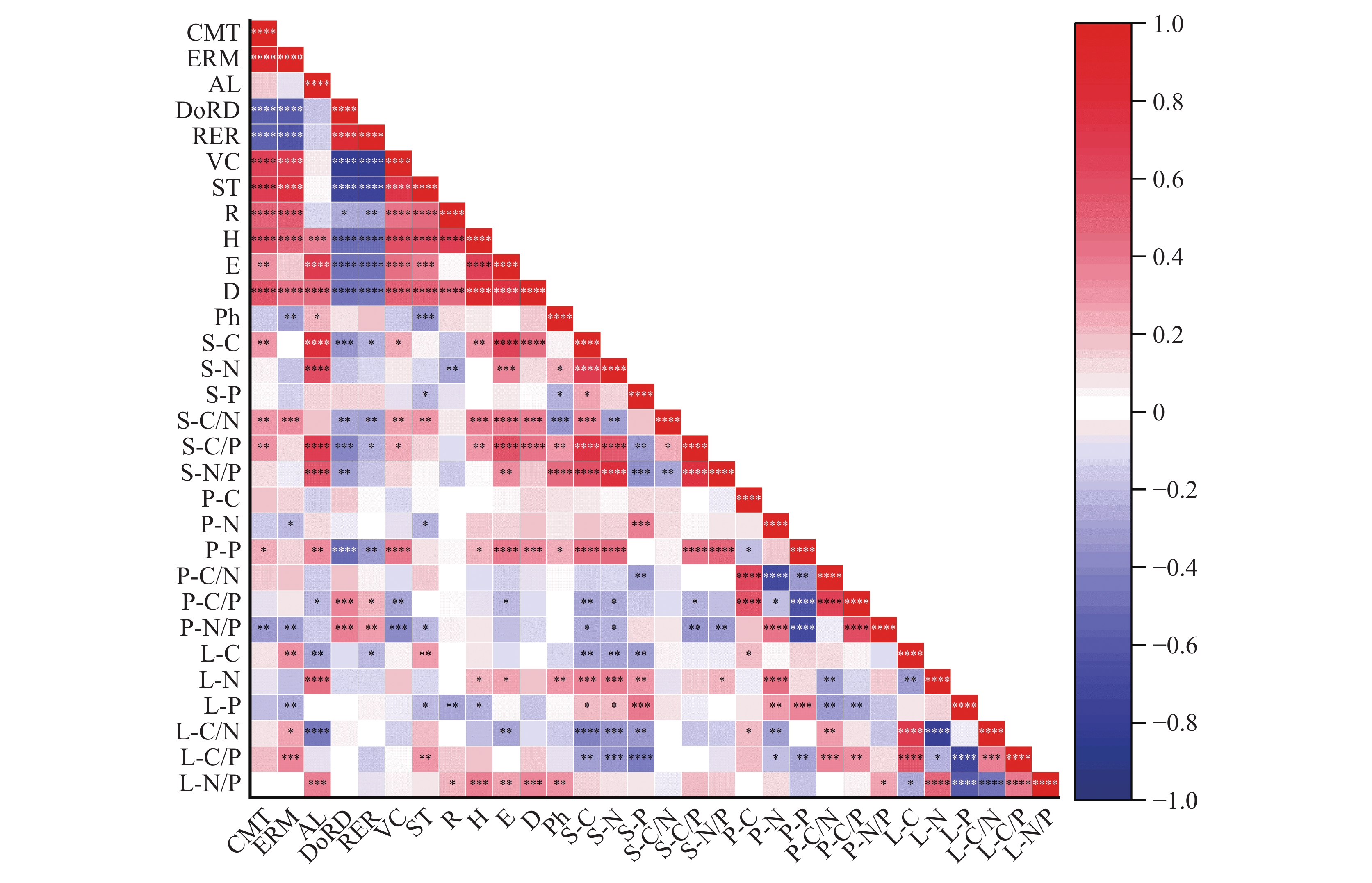
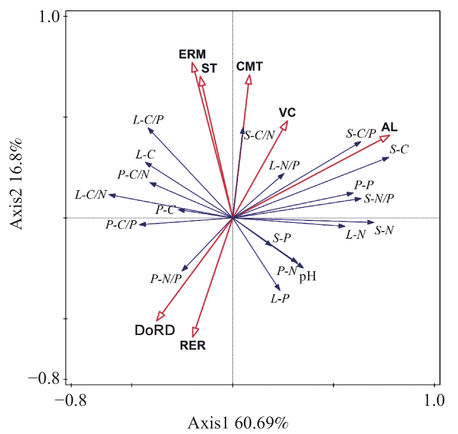
This study focuses on the mid-high mountain karst rocky desertification areas in northwestern Yunnan, aiming to elucidate the stoichiometric characteristics and influencing mechanisms of carbon (C), nitrogen (N), and phosphorus (P) within the soil-plant-litter continuum in this region. It is of great significance for an in-depth understanding of ecosystem cycles in mid-high mountain karst areas and provides theoretical support for ecological restoration efforts.The study area is located in Shuhe town and Jiuhe township, south of Yulong Snow Mountain, on the southeastern edge of the Qinghai-Xizang Plateau. It lies within the transition zone between China's first and second terrain steps. The region features complex terrain with numerous high mountains and valleys, and an altitude ranging from 2,544 m to 3,090 m. Carbonate rocks are widely distributed, with limestone as the main soil-forming parent material, resulting in an extremely slow rate of soil formation through weathering; The predominant soil type is brown soil. The area experiences a plateau monsoon climate characterized by distinct dry and wet seasons, an annual average temperature of 13℃ to 20 ℃, and an annual average rainfall of 950 mm to1200 mm, over 85% of which occurs between May and October. Solar radiation remains strong throughout the year. Vegetation is characterized by xerophytism, lithophytism, and calciphilia, with key species including Arundinella hookeri Munro ex Keng, Tripogon yunnanensis J. L. Yang ex S. M. Phillips & S. L., Festuca ovina L., Lespedeza forrestii Schindl., Rhododendron racemosum Franch., Quercus guyavifolia H. Lév., Cotoneaster microphyllus Wall. ex Lindl., Pinus yunnanensis Franch., Juniperus formosana Hayata, Cupressus duclouxiana Hickel.Targeting the ecological vulnerability of mid-high mountain karst areas and addressing existing research gaps, this study analyzes the C, N, and P contents and stoichiometric characteristics of soil, plants, and litter under different vegetation community types. It further explores the impacts of community types and environmental factors on nutrient cycling. This study focuses on answering two core questions: first, the variation patterns of C, N, and P contents and ecological stoichiometric characteristics in the soil-plant-litter continuum; Second, the specific effects of vegetation community types on C, N, and P contents within this continuum.From July to August 2023, the survey was conducted in the study area encompassing five typical community types: grassland, shrub-grass, arbor-shrub-grass-cypress, pure pine, and arbor-shrub-grass-pine. The grassland type includes three communities, while the shrub-grass, arbor-shrub-grass-cypress, pure pine, and arbor-shrub-grass-pine types each included five communities, totaling 23 communities. For each community, three parallel sample plots were selected, resulting in a total of 69 sample plots. In each sample plot, a standard 10 m×10 m quadrat was established, along with a representative 5 m×5 m shrub quadrat and five 1 m×1 m herb quadrats arranged using the plum-point method. Indicators such as geographical location, altitude, community type, ecological restoration measures, soil thickness, vegetation coverage, rock exposure rate, and degree of rocky desertification were recorded. Community diversity was assessed using indices such as species richness and the Shannon-Wiener diversity index. Samples were analyzed for C, N, and P contents and stoichiometric characteristics of soil, plants, and litter, as well as the influence of environmental factors.The research results show that the average contents of soil C, N, and P across different community types were 7.46 to 43.25 g·kg−1, 1.05 to 2.96 g·kg−1, and 0.39 to 0.53 g·kg−1, respectively. The soil C/N, C/P, and N/P ratios ranged from 8.82 to 23.25, 21.74 to 105.25, and 2.89 to 6.33, respectively. Plant C, N, and P contents were 373.79 to 622.87 g·kg−1, 10.47 to 15.56 g·kg−1, and 1.43 to 2.14 g·kg−1, with plant C/N, C/P, and N/P ratios of 27.10 to 65.13, 272.85 to 624.26, and 7.23 to 10.72, respectively. Litter C, N, and P contents were 334.93 to 491.73 g·kg−1, 7.00 to 16.61 g·kg−1, and 1.16 to1.53 g·kg−1, with litter C/N, C/P, and N/P ratios of 23.70 to 72.17, 238.49 to 499.18, and 7.61 to 17.49, respectively. Significant differences were observed in the C, N, P contents and stoichiometric ratios of soil, plants, and litter among different community types. Soil and plant C and N nutrients generally showed a trend of gradual enrichment as community types transitioned from grassland to arbor, Specifically, the arbor-shrub-grass-pine, pure pine, and shrub-grass stages generally showed higher nutrient levels than the grassland and arbor-shrub-grass-cypress stages, while litter exhibited the opposite trend. Soil was generally deficient in P, but plants and litter did not exhibit signs of P deficiency. In terms of stoichiometric ratios, and soil C/N, C/P, and N/P ratios in pure pine, arbor-shrub-grass-pine, and shrub-grass types were significantly higher than those in arbor-shrub-grass-cypress and grassland types. Conversely, plant and litter C/N and C/P ratios in arbor-shrub-grass-cypress type were significantly higher than those in other types. There were widespread correlations in nutrient contents among soil, plants, and litter. Environmental factors such as community type, altitude, and degree of rocky desertification had significant impacts on stoichiometric characteristics, with complex correlations among factors. The relative importance of these influences was ranked as follows, altitude > ecological restoration measures > degree of rocky desertification > community type > soil thickness > vegetation coverage.Vegetation growth in mid-high mountain karst areas is jointly limited by N and P, with the degree of limitation varying among different community types. Compared with herbaceous and low shrub communities, arbor communities are more strongly constrained by N.
Wavelet transform analysis of the response mechanism of CO2 concentration to tourist activities in Zhijin Cave
ZHANG Hongzhi, WU Kehua, LUO Shuwen
2025, 44(6): 1241-1254. doi: 10.11932/karst20250607
Abstract:
Karst caves are among the most frequented visited geological sites worldwide. However, their stable environments are vulnerable to changes caused by tourist activities, including variations in temperature, CO2 concentrations, humidity, airflow, microbial communities, and groundwater chemistry. Therefore, it is imperative to investigate the impact of tourist on cave ecosystems and to implement strategies aimed at enhancing the overall environmental quality of these caves. These efforts are crucial for ensuring the sustainable development of tourist caves.As a principal driver of karst processes, CO2 has garnered considerable attention in the fields of regional carbon cycling, weathering of cave sedimentary landscapes, and the analysis of cave ecological capacity. Prior research primarily focused on the characteristics of CO2 concentration variations, their sources, and influencing factors within tourist caves. Observations of diurnal and nocturnal fluctuations in CO2 concentrations clearly indicate that tourist activities exert a significant influence on these variations. However, monitoring of CO2 concentrations prior to development has not been conducted in most tourist caves, which limits the ability to accurately assess the extent of tourist impact on CO2 dynamics. The closure of tourist caves during the COVID-19 pandemic has provided a unique opportunity for comparative analyses. Currently, statistical analyses of CO2 concentrations in tourist caves predominantly rely on line graphs and scatter plots, which illustrate magnitude and variability but fail to accurately capture frequency variations across multiple temporal scales. Moreover, the depth of data exploration remains limited. Additionally, studies exploring the temporal variations of CO2 concentrations in relation to tourist volume often involve a degree of subjectivity. While, wavelet transform techniques can effectively reveal the periodic temporal-frequency characteristics of time series data across various scales, while precisely depicting the lag between dynamic changes in time series and their influencing factors. This methodological approach effectively addresses the existing gaps in research concerning CO2 levels in tourist caves. This study utilizes monitoring data on temperature, CO2 concentrations, and tourist volume from Zhijin Cave during both the lockdown and operation period. By employing wavelet transform for comprehensive time-frequency and lag analysis across multiple temporal scales, this research aims to provide an accurate assessment of the impact of tourist activities on CO2 concentrations within the cave, ultimately offering a scientific foundation to enhance predictive capabilities regarding CO2 levels in Zhijin Cave.The results reveal that following disturbances caused by tourist activities, the average temperature within Zhijin Cave increased by 0.23 to 0.86 °C, with notable variations observed among different monitoring sites. Compared to the lockdown period, CO2 concentrations within the cave exhibited a marked increase during peak tourist hours of the operation period. Subsequently, the decline in CO2 levels at monitoring points 3 and 4 was relatively gradual, whereas points 5 through 7 demonstrated a rapid decrease. During the operation period, the long-term periodicity of CO2 concentrations in Zhijin Cave was shorter than that recorded during the lockdown, with significant short-term fluctuations closely associated with variations in daytime visitor flows. During the holiday period (September 30 to October 4), a significant positive correlation was identified between CO2 concentrations and tourist volume within the cave. The response of CO2 concentrations to tourist activities displayed a distinct lag effect across both diurnal and nocturnal time scales. Overall, it was found that larger cave volumes were associated with longer lag times for CO2 concentrations in response to changes in tourist volume. These findings provide valuable insights for analyzing the changes in CO2 concentrations within tourist caves under relatively natural conditions and offer a scientific foundation for effective cave management. However, it is important to note that this study did not include monitoring of CO2 concentrations in the overlying soil, which limits the availability of direct data to characterize soil CO2 variations during the lockdown period. Additionally, the elevated visitor numbers during peak holiday periods influenced the correlation between CO2 concentrations and visitor counts during non-holiday intervals. Therefore, a comprehensive consideration of data comparisons during non-holiday periods is warranted. Furthermore, the analysis was conducted over a limited timeframe, which restricts its broader applicability. It is suggested that future research should adopt innovative analytical methodologies to investigate the response of CO2 concentrations in the cave to tourist volume across seasonal and interannual scales.
Cultivated land fragmentation and its influencing factors in karst mountainous areas from the perspective of geomorphic differentiation
DUAN Yujie, ZHAO Yuluan, ZHOU Chunfang
2025, 44(6): 1255-1269. doi: 10.11932/karst20250608
Abstract:
The fragmentation of cultivated land, as a land use pattern contrasting with large-scale farming operations, constrains agricultural modernisation and sustainable development. This is particularly pronounced in the karst mountainous regions of southwestern China, where factors such as the fundamental agricultural conditions of large population and limited land, the egalitrian allocation method of matching fertile and infertile plots, combining with distant and nearby plots, and the complex natural environment dominated by mountainous terrain have led to a marked pattern of cultivated land fragmentation. Consequently, targeted research holds significant importance for ensuring food security and achieving cultivated land comprehensive governance in karst mountainous areas. The Qixingguan District, situated in northwestern Guizhou Province, exhibits a topography that slopes from southwest to northeast in a terraced descent. The terrain is complex, characterised by extensive mountainous hills and limited plains or basins, with karst landforms such as peak clusters and trough valleys developed throughout. The region's geology is dominated by carbonate rocks and basalt, with pronounced rock desertification, making it a quintessential example of China's ecologically fragile karst areas in the southwest. Furthermore, the spatial distribution of cultivated land presents the characteristics of scattered, small, and fragmented, with sharp contradictions between people and land, providing an ideal case area for the study of cultivated land fragmentation. This study employs 37 townships and sub-districts, encompassing 477 administrative villages within Qixingguan District, as its research units. Drawing upon data from the Third National Land Survey, rural land contract management rights, and farm household surveys datas, it aims to systematically reveal the characteristics, patterns and spatial correlations of cultivated fragmentation across different landform types, accurately identify the key influencing factors and their respective intensities, and thereby provide a scientific basis for the comprehensive governance of cultivated land fragmentation in karst mountainous areas. The research methodology primarily comprises, (1) Delineating landform types within the study area by integrating regional topographic characteristics and relevant classification standards; (2) Constructing an evaluation index system for cultivated land fragmentation from dual perspectives of landscape and ownership to comprehensively characterise fragmentation status; (3) Employing spatial autocorrelation analysis to reveal the spatial distribution patterns and correlation characteristics of cultivated land fragmentation; (4) Utilising multiple linear regression models and geographic detector models to quantify the intensity of influence and regional variations of each factor on landscape fragmentation and ownership fragmentation. The research findings indicate, (1) The landforms of Qixingguan District can be categorised into four types: low mountain valley slopes, medium mountain hilly terraces, medium mountain valley terraces, and medium mountain hilly slopes. The number of administrative villages covered by each landform type is 49, 162, 81, and 185, respectively; (2) Qixingguan District exhibits high levels of cultivated land fragmentation, with ownership fragmentation exceeding landscape fragmentation. Distinct high-value and low-value zones are discernible. Administrative villages in medium-mountain valley slopes and medium-mountain hilly slopes demonstrate stronger cultivated land resource scale and spatial aggregation, while those in low-mountain river valley slopes and medium-mountain hilly slopes exhibit greater operational intensity; (3) The spatial distribution of cultivated land fragmentation in Qixingguan District exhibits correlations, with distinct combinations of topographic features: low mountain river valley slopes show high landscape fragmentation and low ownership fragmentation; medium mountain valley slopes exhibit high ownership fragmentation and low landscape fragmentation; medium mountain upland terraces demonstrate high levels of both landscape and ownership fragmentation; while medium mountain upland slopes display relatively low levels of both; (4) Landscape fragmentation is primarily influenced by the proportion of construction land, elevation, and terrain dissection. Specifically: low mountain river valley slopes and medium mountain hilly slopes show positive correlations with slope gradient; medium mountain slope valleys correlate positively with terrain dissection; while medium mountain hilly terraces are driven by the proportion of construction land. The key drivers of ownership fragmentation are the proportion of construction land and rural population density. Among these, rural population density is the core driver for low mountain river valley slopes, medium mountain slope valleys, and medium mountain hilly slopes, while medium mountain terraced land primarily exhibits a positive correlation with per capita cultivated land area. Based on the distinctive characteristics of cultivated land resources across different topographic zones, this study proposes a comprehensive approach to cultivated land resource goverance encompassing landscape, land tenure, and land use practices. This framework provides scientific support for optimising cultivated land distribution, advancing land transfer and consolidation, and enhancing agricultural scale in Qixingguan District and karst mountainous areas of Southwest China. It holds significant practical value for safeguarding regional food security and propelling agricultural modernisation.
Exploration and 3D visualization of leakage channels of tailings ponds in karst regions:A case study of Zhatang Tailings Pond in Guiyang City
MA Lanjian, CHEN Shiwan, CAI Liangjun, LUO Yongfei, LI Jianzhang, JI Zhihao, LONG Weijun, XIONG Hai, TIAN Lang, WU Pan
2025, 44(6): 1270-1290. doi: 10.11932/karst2024y041
Abstract:
Karst regions are rich in mineral resources, and tailings ponds-essential facilities for maintaining normal production in mining enterprises-are often inevitably constructed on carbonate formations in these areas. However, the complex hydrogeological conditions in karst regions, including well-developed karst features such as sinkholes, swallow holes, and underground karst channels, make tailings ponds highly susceptible to leakage. This leakage can lead to surface and groundwater contamination, posing significant challenges to regional groundwater pollution control. Therefore, identifying underground karst channels beneath tailings ponds and characterizing their leakage patterns are critical for mitigating pollution in karst regions. To investigate leakage channels in karst tailings ponds, this study focuses on the Zhatang red mud tailings pond in Guizhou Province, which is located in a well-developed karst region and has experienced leachate leakage. A systematic approach integrating geophysical exploration techniques-including the high-density resistivity method and transient electromagnetic method-hydrogeological drilling, tracer tests, and 3D geological modeling was employed to identify karst leakage channels and construct a detailed visual model. Dense survey lines for the transient electromagnetic and high-density resistivity methods were arranged in a grid pattern within Ponds 2, 5, and 6. Using the inverse distance weighting (IDW) algorithm, 3D resistivity models of the strata were developed, effectively identifying low-resistivity anomalies in the pond area. The models revealed that the low-resistivity anomalies in Pond 5 and Pond 6 predominantly exhibited a north-south distribution, corresponding to the main leakage channels toward the Damawo, Lujiawan, and S703 seepage points. In Pond 2, a banded low-resistivity anomaly extending southeast was identified as the leakage channel for the S704 spring. Based on the 3D resistivity models, additional high-density resistivity and transient electromagnetic survey lines were deployed outside the pond area to further delineate the developmental patterns of karst leakage channels. The integrated interpretation of exploration results from both inside and outside the pond area clarified the spatial distribution characteristics of these leakage channels. Hydrogeological drilling, borehole television imaging, and tracer tests were conducted to validate the karst leakage channels identified by geophysical methods. Drilling results confirmed that the low-resistivity anomalies corresponded to fractured zones and areas filled with high-concentration leachate. For instance, boreholes Z11 and Z16 intercepted leachate-saturated zones, while Z17 and Z19 revealed intense shallow karst development. Boreholes Z15 and Z14 demonstrated the hydraulic connectivity of dissolution cavities along lithological boundaries. Tracer tests further verified the karst leakage channel toward the S704 spring.By combining geophysical exploration with 3D geological modeling and integrating multi-source data-including 119 actual boreholes, 104 virtual boreholes, geophysical interpretation results, and UAV topographic surveys-a refined 3D geological model and a leakage channel model of the study area were developed. The 3D geological model visually represents stratigraphic interfaces, lithology, terrain, fault distributions, and tailings pond boundaries, enabling cross-sectional visualization at any location. The leakage channel model accurately identifies karst leakage channels and lateral groundwater recharge channels, clearly delineating the spatial distribution pattern of pollution sources (low-resistivity zones within the pond), migration channels (karst channels controlled by structures or stratigraphic boundaries), and discharge endpoints (springs). This model elucidates the groundwater "recharge-flow-discharge" system in the study area. The leakage channel model demonstrates that groundwater movement is primarily controlled by structural and stratigraphic boundaries, with karst leakage zones predominantly developing along faults and lithological interfaces. For example, the Lujiawan and S703 spring channels are associated with faults F3 and F5, while the S704 spring channel follows the boundary between the Longtan and Maokou Formations. The karst channel model visualizes the spatial distribution of underground features and the leachate migration process, providing critical insights for assessing groundwater contamination risks and designing remediation strategies for the Zhatang red mud tailings pond. This study innovatively integrates geophysical exploration with 3D geological modeling, enabling comprehensive analysis of geological data and overcoming the limitations of traditional 2D interpretations. In scenarios with limited borehole data, this method significantly enhances the accuracy of detecting karst groundwater channels and improves model representation. It offers a novel approach for precisely locating leakage channels and visualizing pollution processes in karst tailings ponds. The research findings provide a scientific foundation for designing remediation measures such as grouting leakage channels and altering flow directions, thereby substantially reducing wastewater treatment costs and yielding significant environmental and economic benefits.
Study on multi-scale geophysical detection methods for vertical dissolution fissures in limestone areas
XI Chunfei, NIU Guangtian, LI Fan, CHEN Di, CHEN Huapeng, LEI Qiguo
2025, 44(6): 1291-1300. doi: 10.11932/karst2025y025
Abstract:
To address the challenges of strong concealment and high detection accuracy requirements for vertical dissolution fissures in limestone areas, this study proposes a multi-scale integrated detection system that combines high-density Electrical Resistivity Tomography (ERT) for macro-scale anomaly delineation with cross-hole electromagnetic wave CT imaging for refined characterization. Through numerical simulations comparing the vertical fissure identification capabilities of the Wenner array, three-pole array, and dipole-dipole array, the dipole-dipole array-with superior lateral resolution and noise resistance-was selected for field experiments. The ERT method rapidly delineated low-resistivity anomaly zones, while cross-hole electromagnetic wave CT imaging precisely resolved fissure development characteristics. The results demonstrate that the dipole-dipole array effectively reconstructs the spatial distribution of vertical fissures. Strong absorption anomaly zones identified by electromagnetic wave CT spatially align with ERT-derived low-resistivity anomalies. Borehole coring revealed significantly higher rock fragmentation in geophysically delineated fissure zones compared to adjacent layers, validating the reliability of the geophysical results. This integrated technical framework provides scientific support for concealed fissure identification, engineering stability evaluation, and geological hazard prevention in karst regions.This study area is located in Yichang City, Hubei Province. Geological structure and weathering/erosion processes have resulted in steep terrain with significant slopes. Well-developed solution grooves, varying in width from centimeters to meters and in depth from shallow surface etching to several meters, are evident on the rock surfaces. Ground fissures are often filled with argillaceous material. Bedrock (limestone) is extensively exposed in the area. A specific ground fissure was observed, approximately 30 meters in length, with an average width of 0.5 meters and a visible depth ranging between 0.5 to 2 meters. This fissure trends approximately N10°E and extends towards a vertical dissolution slot to the north. This slot feature is about 100 meters in height and exhibits dense vegetation growth within. Given its characteristics and proximity to the slot, it is inferred that this surface fissure may extend downward into the subsurface rock mass, prompting the implementation of our geophysical investigation here.Building upon previous research and site survey, we first constructed a digital resistivity model for forward modeling. Comparative analysis of various electrode array configurations and noise levels led to the selection of a dipole-dipole array with a minimum electrode spacing of 5 meters for the initial, broad-scale delineation of the fissure zone. Results successfully located the fissure, and a confirmation borehole drilled within the anomalous resistivity zone revealed highly fractured core material, providing strong validation for the effectiveness of the ERT method in identifying fractured regions. However, inherent limitations of the ERT method concerning site conditions and resolution meant the delineated fissure boundary remained relatively broad. To achieve a more precise characterization of the dissolution fissure's morphology and extent, cross-hole electromagnetic wave CT was subsequently conducted between the boreholes,which provided detailed imaging of the subsurface dissolution features.
Application and effectiveness of high-density electrical method in the karst ground subsidence zone of Laiwu
SUN Hongjie, WANG Zhihui, ZHAO Zhenhua, LUO Zhenjiang
2025, 44(6): 1301-1310. doi: 10.11932/karst20250609
Abstract:
Frequent karst subsidence in China’s carbonate regions poses a significant geological hazard that requires urgent attention. This issue often arises from excessive groundwater extraction for domestic, irrigation, industrial, and mining purposes, inducing declining water levels and sharp fluctuations that exacerbate of karst subsidence. The resultant risks include severe safety concerns and substantial property damage for residents in affected areas, posing a serious threat to personal safety and infrastructure development. Since the 1970s, karst collapse incidents have been frequent in Laiwu District, Jinan City, causing significant risks and property damage to nearby inhabitants. Therefore, focusing on Laiwu as the research area is crucial for conducting surveys of karst subsidence regions using physical exploration methods and establishing a comprehensive karst geological database. This database is instrumental in identifying vulnerable areas prone to karst subsidence and developing effective preventative and control measures. Given the higher prevalence of karst collapse risks near fracture tectonic zones, a detailed understanding of karst development features beneath known collapse areas and within fracture zones is essential for a comprehensive assessment of karst collapse characteristics.Located in the central mountainous region of Shandong Province, Laiwu is surrounded by mountains, with a broader expanse of terrain in the west, presenting a basin-like tilt from east to west. Geologically, the area can be categorized into four types: erosion-tectonic middle mountainous areas, erosion-tectonic low mountainous zones, erosion-tectonic hilly regions, and intermontane plains. The surface-exposed strata and borehole data in and around the study area predominantly consist of Paleozoic Cambrian, middle and lower Ordovician, Carboniferous, Permian, Mesozoic upper Jurassic, Cenozoic Paleocene, and Quaternary formations. The study zone is delineated into northern and southern sections. The northern section encompasses the Dawangzhuang–Zhailizhen area, while the southern section extends from Mengjiazhuang village in the east to Xiquanhe village in the south, and from Xiquanhe village in the west to Menggongqing village in the north. Topographically, the study site features a northward-protruding semicircular basin with gentle slopes descending from east to west, characterized by mild gradients in the south and steeper inclines in the north. The terrain inclines northward, eastward, and southward, converging toward the basin’s center to form a horseshoe shape that opens westward, bisected by the east-west course of the Dawenhe River running through the central basin. The local climate is classified as a mid-temperate continental monsoon climate, exhibiting distinct seasonal changes with cool springs and autumns, cold winters, and hot summers. Significant variations in annual rainfall and its regional distribution are observed, with higher precipitation recorded in the southeast and northwest. The primary rivers in the study area include the Mouwenhe River and the Zhailihe River, along with the Fangxiahe River, the Simahe River (a tributary of the Mouwenhe River), and the Zhifenghe River (a tributary of the Zhailighe River). These tributaries exhibit seasonal flow patterns and short courses, experiencing rapid water level fluctuations during rainy periods and reduced flow or potential drying during dry spells. This investigation aims to evaluate the effectiveness of three geophysical exploration methods-the geo-radar, shallow seismic, and high-density resistivity-in the Laiwu karst collapse area. The main findings are summarized as follows, (1) The Schlumberger device exhibits a strong performance across four models, boasting exceptional horizontal and vertical resolution and effectively delineating the location, shape, and size of target bodies. Therefore, in the vicinity of concentrated ground collapse in Laiwu, Shandong Province, we deployed a network of Schlumberger devices for measurements, utilized RES2Dmod for data modeling, and conducted numerical simulations. (2) Several fracture tectonic zones were identified, along with karst regions characterized by low-resistance anomalies and various filling conditions. Both 2D and 3D results highlighted the method’s effectiveness, particularly in detecting hidden karst formations and infill materials, thereby providing a foundational and comparative framework for engineering case analyses. (3) Multiple fracture configurations were revealed through drilling, including those intersected by all measurement lines, confirming the robustness of the high-density resistivity method in detecting such structures. This method demonstrates distinct anomaly response characteristics, delivering high precision and accuracy. (4) The Schlumberger device’s excellent vertical and horizontal resolution offers significant practical value for detecting and predicting potential ground collapses in karst development regions. Rigorous verification through joint borehole assessments enhances the study’s credibility, indicating that the subsidence may result from diagonal erosion-induced migration of sand and soil particles from overlying layers into adjacent karst conduits or voids, ultimately leading to collapse pit formation. In conclusion, this study offers the following recommendations, (A) In karst collapse-prone areas, regular inspections are advised to detect subsurface voids beneath roadways. (B) Expanding the scope of gravity and magnetic surveys is encouraged to better characterize the distribution of fracture tectonics across the area.
Application of high-density electrical method in karst exploration in Liannan county, Guangdong
ZHAO Libo, JIANG Shoujun, NI Zehua, TU Shiliang, HUANG Wenlong, ZHUANG Zhuohan
2025, 44(6): 1311-1320. doi: 10.11932/karst20250610
Abstract:
In covered karst areas, the Quaternary overburden is connected to underlying karst cavities and fissure networks, making these regions susceptible to karst ground collapses due to natural or anthropogenic factors. The northwestern Guangdong region is widely distributed with extensive carbonate rock formations where karst processes are prominent. In recent years, the increasing frequency of extreme climate events has intensified the occurrence of shallow covered karst collapse disasters in this area. These disasters are widespread, highly concealed, and sudden, posing a significant threat to the safety of lives and property. Therefore, studying the geological structural characteristics of potential karst ground collapse zones is of considerable practical significance and profound social value. The high-density resistivity method comprises a set of direct current (DC) electrical exploration techniques that exploit the differences in electrical properties between subsurface targets and surrounding media. This method involves artificially establishing a stable DC electric field underground and performing scanning observations using a predetermined electrode array configuration. By analyzing extensive spatial variations in resistivity within a specific subsurface area, it enables the investigation and elucidation of relevant geological issues. The high-density electrical method has proven valuable in various scenarios involving karst ground collapses. For example, in geological surveys of covered karst areas, the Wenner quadrupole array has been used to detect underground cavities, yielding results that align well with borehole data. Therefore, this study selects a typical shallow covered karst collapse-prone area in Liannan county, Qingyuan City, to investigate the distribution and development characteristics of underground karst using the high-density electrical method combined with drilling. First, the profile of a high-density electrical test was established in Meicun, Liannan county, where data were collected using both the Wenner and Schlumberger array. Inversion was performed on the respective datasets as well as on the combined array data. The inversion profiles clearly reveal significant high-resistivity zones interspersed with low-resistivity anomalies. The Wenner array inversion profile displays a relatively wide low-resistivity anomaly zone located between 185 m and 225 m along the survey line, with a lateral extent of about 40 m and a depth of about 30 m, covering an area of approximately 1,200 m2. However, the resistivity contour anomaly zone is not distinctly delineated. In contrast, the Schlumberger array inversion profile reveals a narrower anomaly zone located between 180 m and 205 m along the survey line, with a lateral extent of about 25 m and a depth of about 25 m, covering an area of approximately 625 m2. The resistivity contour anomaly zone is more clearly defined, exhibiting sharper lateral boundaries. The combined array provides a more refined depiction of the anomaly zone, better constraining the subsurface anomaly. By integrating borehole data, it was concluded that both arrays accurately reflect the low-resistivity anomaly zone. In terms of detection objectives, the Wenner array is better suited for identifying layered structures, while the Schlumberger array excels at delineating anomalous bodies. Simultaneously, joint inversion of the combined arrays leverages the strengths of each array to improve resolution. Second, analysis of the single-point apparent resistivity sounding curve extracted from borehole locations shows that the resistivity value is about 100 Ω·m at the minimum electrode spacing of 7.5 m. As the spacing increases, the resistivity gradually decreases, stabilizing at 22.5 m, followed by a turning point of increasing resistivity at 27.5 m, which is inferred to be the rock-soil interface. As the resistivity continues to rise, a V-shaped anomaly appears in the 47.5 to 57.5 m segment, likely caused by karst fissures or partially to fully filled cavities. The anomaly location on the sounding curve aligns well with borehole findings. Finally, the high-density electrical method was applied to analyze the study area. The results indicate the followings, (1) Different acquisition arrays exhibit distinct characteristics in the resistivity contours of the same target during inversion. Therefore, the optimal array should be selected based on the detection objective prior to fieldwork, and combining multiple arrays can enhance resolution. (2) Integrating high-density electrical inversion results with single-point apparent resistivity sounding curves can improve the accuracy of borehole placement. (3) The high-density electrical method can precisely delineate the rock-soil interface, measure overburden thickness, and successfully identify eight karst anomaly zones and two underground karst development belts. These geophysical inferences show strong consistency with verification borehole data. (4) This study successfully delineated eight potential karst collapse hazard zones. Overall, the research demonstrates that the high-density electrical method is highly effective in identifying cavities and karst fissure zones, providing critical and reliable support for subsequent prevention and mitigation efforts.
Analysis of dynamic evolution characteristics of mining-induced landslide based on multi-source remote sensing data: A case study of Jianshanying landslide
YAN Haoyuan, FENG Han, XIE Mingli, LIU Zheyan
2025, 44(6): 1321-1330, 1343. doi: 10.11932/karst20250611
Abstract:
Landslides occurring on mountain slopes due to deformation and failure of overlying rock masses under the influence of underground mining activities are referred to as mining-induced landslides. Slopes exhibiting deformation caused by such activities but have not yet experienced sliding failure are classified as mining-induced slopes. Mining-induced landslides are characterized by complex deformation and failure mechanisms, as well as prolonged development periods. They cause irreversible damage to the mountain geological environment. These slopes often undergo extended periods of stress adjustment and deformation evolution, leading to the formation of numerous mining-induced fractures within the slope mass. Simultaneously, multiple collapse troughs and subsidence basins develop on the slope surface, significantly reducing the integrity of the rock mass. Under favorable free-face conditions at the front of a slope, sudden-onset geological disasters are highly likely to occur. Mining landslides represent a critical area of research on geological hazards. Analyzing both their surface deformation and historical deformation holds significant importance for the identification and early warning of mining-induced landslides. In recent years, to facilitate convenient and intuitive identification, investigation, and monitoring of geological hazards, technologies such as Spaceborne Interferometric Synthetic Aperture Radar (InSAR), high-resolution optical satellite imagery, Unmanned Aerial Vehicle (UAV) aerial photography, and Airborne Light Detection and Ranging (LiDAR) have been widely used. Notably, combining space-borne, airborne, and ground-based platforms facilitates multi-method, multi-scale, and long-term monitoring of the deformation and failure characteristics of geological hazards. This integrated approach addresses a critical need and represents a key direction for advancing early identification, and disaster prevention and mitigation of landslide hazards. Jianshanying landslide is located in Fa’er Town, Liupanshui City, Guizhou Province. The landslide site has experienced deformation for many years due to repeated multi-seam mining operations. Ultimately, it slid in September 2020 as a result of the combined effects of long-term mining activities and rainfall. This landslide is a typical example of mining landslide occurring in the karst terrain in Guizhou Province. This study adopts an integrated space-air-ground approach to conduct a multi-dimensional analysis of the historical dynamic changes of Jianshanying landslide. Research shows that mining-induced landslides like Jianshanying landslide, caused by repeated multi-seam mining, exhibit significant deformation magnitudes. Prolonged mining activities combined with rainfall increase the susceptibility to landslides. Comparative analysis of multi-temporal optical remote sensing imagery and UAV data can reveal the macro-scale deformation variations at different locations of the landslide over time. Long time-series Synthetic Aperture Radar (InSAR) technology can accurately capture the spatio-temporal evolution patterns of surface deformation. Additionally, surface point cloud data acquired by airborne LiDAR can provide detailed information on elevation changes and micro-geomorphological characteristics of the landslide. Through a comprehensive interpretation of the aforementioned remote sensing means, combined with field investigations and analysis of the landslide’s engineering geological and mining conditions, the following conclusions are established: as early as before 2013, Jianshanying landslide exhibited relatively obvious disaster features, such as the main scarp, landslide boundaries, and terraces. With the progression of mining activities, by 2016, Jianshanying landslide gradually transformed from multiple deformation bodies into a single integrated mass. Rear tension cracks appeared around 2016 as visibly open fissures. After 2017, these cracks accelerated in both widening and extension. The entire mass displaced downward, resulting in local collapses. Ultimately, under the combined action of long-term repeated mining and rainfall, the landslide occurred in 2020. The deformation of Jianshanying landslide experienced four stages: caving-subsidence deformation, tensile cracking deformation, creep deformation, and shear sliding failure. From the perspective of movement mechanism, it is a typical retrogressive landslide (push-type landslide).
Study on the development model of deep carbonate paleokarst reservoirs in the Tarim Basin
ZHANG Qingyu, NIE Guoquan, JI Shaocong, DONG Hongqi, LI Jingrui, BA Junjie, MO Guochen, ZHANG Meng
2025, 44(6): 1331-1343. doi: 10.11932/karst20250612
Abstract:
As a critical hydrocarbon-bearing basin in China, the Tarim Basin contains exceptionally abundant oil and gas resources within its Paleozoic marine carbonate formations, particularly in the deep subsurface where it exhibits significant exploration potential. However, the complex development patterns of paleokarst reservoirs in carbonate rocks, along with their extreme heterogeneity, pose severe challenges for hydrocarbon exploration and development. This study focuses on the paleokarst reservoirs of representative carbonate oil and gas fields in the Tarim Basin. By integrating multidisciplinary and multitechnique approaches-including core analysis, drilling and logging data, well logging data, high-resolution seismic data, and comprehensive regional geological background materials-this study conducts an in-depth and systematic identification and analysis of paleokarst reservoirs.The findings reveal that the paleokarst development in the Tarim Basin has undergone multiple superimposed transformations. The combined effects of uplift, erosion, and burial have resulted in highly complex heterogeneity characterized by the types, scales, and distribution of reservoir spaces. Paleokarst reservoir spaces primarily include dissolution pores, caves, and fractures; these diverse secondary pore types collectively constitute the main reservoir spaces in carbonate rock formations. Based on the dominant reservoir space categories, the reservoirs can be further subdivided into fracture-dominated, pore-dominated, fracture-pore-dominated, and cave-dominated reservoir types. Paleokarst development is controlled by factors such as tectonic evolution, paleogeomorphology, paleohydrodynamic conditions, and lithology. To identify paleokarst fractures and caves, this study employs a multi-source data fusion approach. Core data provide the most direct and detailed evidence, clearly revealing the macroscopic morphology of dissolution pores, dissolution stylolites, and caves, along with their internal filling characteristics. The filling materials are diverse, including mechanical infillings such as mudstone, breccia, and black organic matter, as well as chemical precipitates like calcite, silica, fluorite, and pyrite, reflecting a multi-stage geological filling process. Drilling, logging, and well logging data indicate the presence of large-scale caves or fractures underground through anomalies such as lost circulation of drilling fluid, increased drilling speed, kick events, and borehole enlargement. In terms of well logging curves, abrupt changes in conventional parameters-gamma values, resistivity, and acoustic transit time-along with dark black features observed in imaging logs, can effectively indicate the presence of underground paleokarst fractures and caves. Seismic data, as a macroscopic detection method, reveals the spatial distribution and geometric morphology of large-scale fracture-cavity bodies through seismic wave characteristics such as frequency reduction, amplitude attenuation, chaotic reflections, weak reflections, bead-like reflections, and low velocity. Morphologically, ancient karst fracture-cavity bodies often exhibit various seismic facies patterns, including "multiple bead-like", "single bead-like", and "continuous sheet-like" forms. Additionally, ancient surface rivers, large karst skylights, sinkholes, entrances and exits of ancient underground rivers, and other karst landform features can be clearly identified on seismic profiles. In summary, guided by modern karst theory and based on the specific karst geological conditions of the Tarim Basin, this study conducted a comprehensive analysis of the types of karst strata groups, the developmental scale of paleokarst fractures and caves, the morphological combinations of paleokarst, the flow characteristics of ancient groundwater, as well as karst features revealed by multi-source data such as drilling, logging, and well testing. It innovatively divided the developmental characteristics of paleokarst fractures and caves in the piedmont area into four vertical zones: the shallow karst zone, the vertical percolation dissolution zone, the runoff dissolution zone, and the subflow dissolution zone. Additionally, lateral comparisons of the karst developmental characteristics across these vertical zones were performed. The shallow karst zone is closely linked to surface water systems, where groundwater primarily undergoes dissolution through horizontal runoff and vertical percolation, making it prone to mechanical filling. The vertical percolation dissolution zone is dominated by vertical percolation with weak lateral connectivity and is primarily characterized by mechanical filling. The runoff dissolution zone is dominated by horizontal runoff, featuring large-scale underground river systems, strong karst action, and mechanical filling, often accompanied by mechanical collapse deposits. The subflow dissolution zone is characterized by deep, slow flow dominated by chemical filling, with frequent occurrences of carbonate minerals such as calcite and dolomite. Building on this foundation, the study comprehensively investigated and summarized the developmental patterns and geological models of paleokarst reservoirs in typical carbonate rock oil and gas fields, including piedmont-type paleokarst, shallow cover-type paleokarst, shore-island-type paleokarst, and fault-controlled paleokarst. By exploring these models, the study elucidated the formation mechanisms of different types of paleokarst and their impacts on reservoir properties, thereby establishing a geological model for the development of paleokarst reservoirs in typical carbonate rock oil and gas fields. This provides important theoretical support and practical guidance for the exploration and development of paleokarst-type oil and gas reservoirs in the Tarim Basin and analogous geological settings worldwide.
Applciation of UVA oblique photogrammetry in multi-scale characterization of Yunhuatan shoal reservoir in the Maokou Formation, central Sichuan Basin: A case study on the Hongyan outcrop section, Huaying
CHEN Cong, DAN Yong, CHI Yuchao, CAO Hua, DENG Min, LI Changwei, YUAN Haifeng, CHENG Jinxiang, WAN Lijun, CHEN Gongyang
2025, 44(6): 1344-1360. doi: 10.11932/karst2025y028
Abstract:
In recent years, guided by the concept of facies-controlled reservoirs, high-quality porous dolomite reservoirs of platform margin facies in Member 2 of the Maokou Formation (Mao-2 Member) have been discovered on the northern slope of Central Sichuan and in the Moxi-Longnüsi–Hechuan-Tongnan area, achieving significant exploration breakthroughs. However, traditional carbonate reservoir characterization is limited by the scale and scope of drilling boreholes. Direct observation at the macro-scale is difficult; multi-scale characterization of the reservoir is even more challenging, and understanding the distribution and development patterns of the reservoir remains elusive. This study employs multiple novel technologies, utilizing macroscopic field outcrops as the research subject, to conduct multi-scale characterization of the dolomite reservoir in the Maokou Formation at the Hongyan Outcrop Section of Huaying Mountain in Central Sichuan. Using UAV oblique photogrammetry and the EPS 3D mapping software system for data processing, a 1.2 km full-section real-scene model of the Maokou Formation was constructed at the macro-scale, with imagery precisely matched to geographic coordinates. For the key reservoir interval of the Yunhuatan Shoal in the lower sub-member of Mao-2 (Mao-2L), medium-scale, high-precision imagery covering approximately 100 meters was acquired via UAV wall-hugging flight, achieving centimeter-level recognition accuracy. Combined with continuous drilling samples, cast thin sections, porosity-permeability tests, and previous research results, the reservoir petrology, pore structure, and petrophysical characteristics of the Yunhuatan Shoal Reservoir interval were systematically studied at the micro-scale. Finally, by integrating macro-(full-section model), meso- (reservoir interval imagery), and micro-scale (thin sections and experiments) data, a 3D parametric model of the Yunhuatan Shoal Reservoir was constructed, enabling the integrated multi-scale characterization of reservoir characteristics. By merging traditional methods with digital technology, this study establishes a "macro-meso-micro" multi-scale research methodology, providing a novel approach for carbonate reservoir characterization.The results indicate as follows, (1) The section comprises the development of two third-order sequences. The Yunhuatan Shoal Reservoir is located in the middle-upper part of Mao-2L, deposited in a shallow environment on the margin of a carbonate platform during the highstand systems tract of SQ1. Reservoir rocks are classified into three types: pure dolomite, transitional lithology dolomite (dolomite with limestone patches or dolomitic limestone), and limestone. Fine-crystalline dolomite within pure dolomite is controlled by the beach core microfacies. Dolomite with limestone patches (dolomitic limestone) and limestone are developed in the beach flank facies, while limestone is controlled by the interbeach microfacies. Sea-level fluctuations controlled the development of two stages of Yunhuatan Shoal. (2) Multiscale reservoir characterization shows that the reservoir space can be classified into three types: (a) Dolomitization-related intercrystalline pores, significantly controlled by facies; (b) Tectonic fractures, related to multi-stage tectonic activity; (c)Dissolution-related pores, intercrystalline dissolution pores, dissolution vugs along fractures, and calcite vugs indicating at least two discrete phases of fluid flow (karst) events, in addition to the current karst-related pores/vugs that has been excluded from this study. (3) Porosity-permeability analysis indicates the following hierarchy: beach core facies > beach flank facies > interbeach facies. Higher proportions of dolomite patches, together with enhanced connectivity, corresponds to improved reservoir quality. Dolomitic patches hosted in limestone exhibit superior porosity and permeability compared to dolomite patches within dolostone. However, when the dolomite content falls below 50%, the porosity and permeability of patchy dolomitic limestone approach those of bioclastic micritic limestone and pure micritic limestone, indicating that dolomitization does not confer a significant petrophysical advantage in such lithofacies.In summary, through multi-scale characterization, a developmental model of the dolomite reservoir in the Mao-2 was successfully established, providing a foundation for subsequent reservoir evaluation and research into its formation mechanisms.