

Risk assessment of geological hazards based on GIS and information modeling method
-
摘要: 地质灾害危险性评价影响因素及评价方法众多,文章以象州县为例,采用信息量模型方法,基于ArcGIS对空间数据的叠加分析功能,选取地貌类型、地质构造、工程地质岩组及地形坡度、岩溶发育程度、斜坡结构、植被覆盖度、人类工程活动8个评价指标,对地质灾害易发性进行评价,在此基础上再选取10年一遇、20年一遇、50年一遇、100年一遇24 h降水量对易发地质灾害危险区进行评价,得出不同降雨工况重现期下,地质灾害危险性级别。评价结果表明,降雨工况重现期越大,地质灾害高危险性及极高危险性分布面积越大,降雨对地质灾害的影响较为显著。象州县地质灾害极高危险区主要分布于中部寺村镇附近河流阶地地貌单元,砂砾石黏土双层结构土体岩组区,东部大乐镇至百丈镇一带及西部马坪镇峰林谷地地貌单元,厚层至块状强岩溶化坚硬灰岩、白云岩岩组区。高危险区主要分布于北东部运江镇、寺村镇至大乐、百丈乡一带以及马坪镇西部丘陵、河流阶地地貌单元;其余地区以中–低危险区为主,地貌单元以丘陵、低山丘陵为主。研究结果可为象州县地质灾害预警预报提供一定的参考。Abstract:
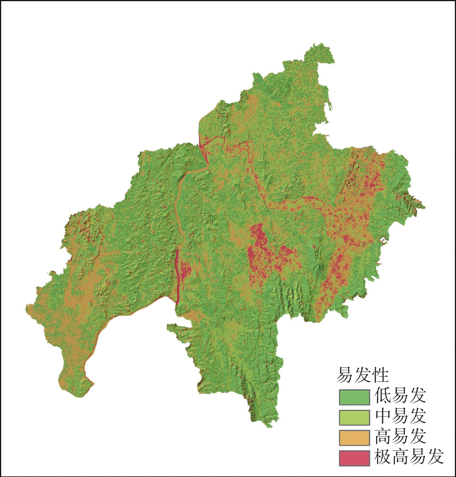
Over the years, geological hazards such as collapses, landslides, hazardous rockfalls, and karst collapses have frequently occurred in Guangxi. These events are widely distributed, have prolonged impacts, affect large populations, and have caused heavy economic losses. Providing fundamental scientific knowledge for disaster prevention and mitigation in the region is of practical importance, as is conducting early prediction and risk assessment of geological hazards. The risk of geological hazards refers to the likelihood of a specific type and scale of hazard occurring within a defined area and time frame, influenced by certain triggering factors. Early prediction and risk assessment of geological hazards remain major challenges in disaster prevention and mitigation. Numerous factors influencing the risk assessment, and various evaluation methods have been employed. This study adopted Xiangzhou county in Guangxi as a case and employed an information modeling method based on an investigation of the main geological conditions controlling potential hazards. Based on the overlay analysis function of ArcGIS on spatial data, eight evaluation indicators were selected according to the characteristics of geological hazard development and potential risks in the study area. These indicators include landform type, geological structure, engineering geological rock group and terrain slope, degree of karst development, slope structure, vegetation coverage, and human engineering activities. The engineering geological rock group and terrain slope were taken as the main controlling factors, while the remaining factors served as secondary factors for overlay zoning. After the natural breakpoint method in statistics was used to reclassify the susceptibility zones, an evaluation grid based on the value of information was generated to assess the susceptibility of geological hazards. The susceptibility of geological hazards in Xiangzhou county is divided into four levels:low, medium, high, and extremely high susceptibility. Areas with extremely high and high susceptibility are mainly located in river terraces, peak forests, and valleys where underground karst development is intense, as well as in rocky mountainous regions, and areas with significant human engineering activities. Areas with medium and low susceptibility are mainly found in hilly and low-mountain terrain. On the basis of susceptibility assessment and the meteorological characteristics of the study area, the maximum 24-hour rainfall data for various return periods were collected from rainfall stations in Xiangzhou county and its surrounding areas. The Kriging method in AcrGIS was used to generate contour maps for rainfall events with return periods in 10, 20, 50, and 100 years. The maps for assessment of geological hazard susceptibility and contour maps for different rainfall conditions were normalized, and spatial overlay analysis was conducted to produce maps for risk assessment of geological hazards corresponding to different rainfall return periods, quantified by the value of information. The risk probabilities was divided into four categories—extremely high risk, high risk, medium risk, and low risk—with the use of the natural breakpoint method, resulting in risk assessments of geological hazards for varying rainfall return periods. The evaluation results indicate that as the return period of rainfall increases, the distribution area in which occur geological hazards with high and extremely high risks also expands. This result reflects that the impact of rainfall on geological hazards is significant. In Xiangzhou county, areas with extremely high geological hazard risk are mainly distributed in the central part near Sicun Town, characterized by river terrace landforms and rock formations with double-layer soil interbedded with sand gravel and clay. Additionally, extremely high-risk zones extend from the eastern Dale town to Baizhang town and to the western Maping town, where peak-forest valley landforms and hard limestone and dolomite rock formations characterized by karst intensely developed from the thick to blocky rocks are prevalent. The high-risk areas are mainly distributed in the hilly and river terrace landforms, including the northeast of Yunjiang Town, the area from Sicun Town to Dale and Baizhang Town, as well as the western part of Maping town. The remaining areas are mainly classified as medium- to low-risk zones, with hills and low mountains as the main geomorphic units. This study scientifically evaluates the geological hazard risks in Xiangzhou county, Guangxi, highlighting the key factors and adapting measures to local conditions. It categorizes different levels of geological hazard risks, and clarifies the zoning of these risks under different rainfall conditions. The findings provide a valuable reference for warning and forecasting geological hazards, improving the technical support system for hazard identification, zoning, and control in the study area. At the same time, the evaluation results can inform national spatial planning by guiding the population and economic activities to concentrate in low-risk areas in an orderly manner. -
Key words:
- ArcGIS /
- information modeling methods /
- geological hazard /
- rainfall conditions /
- hazard assessment
-
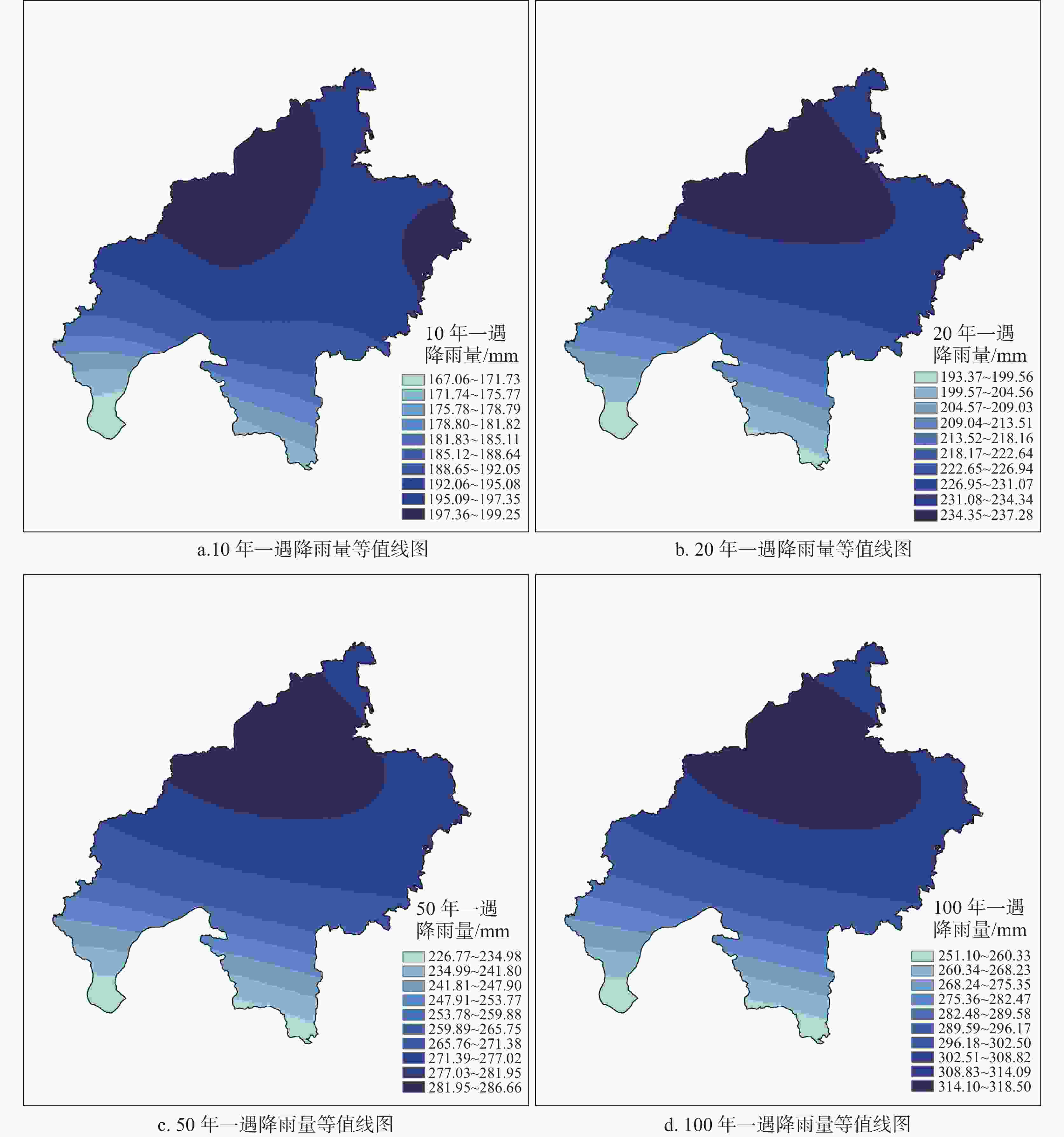
图 3 不同降雨重现期下降雨量等值线图
Figure 3. Rainfall contour map under different rainfall conditions
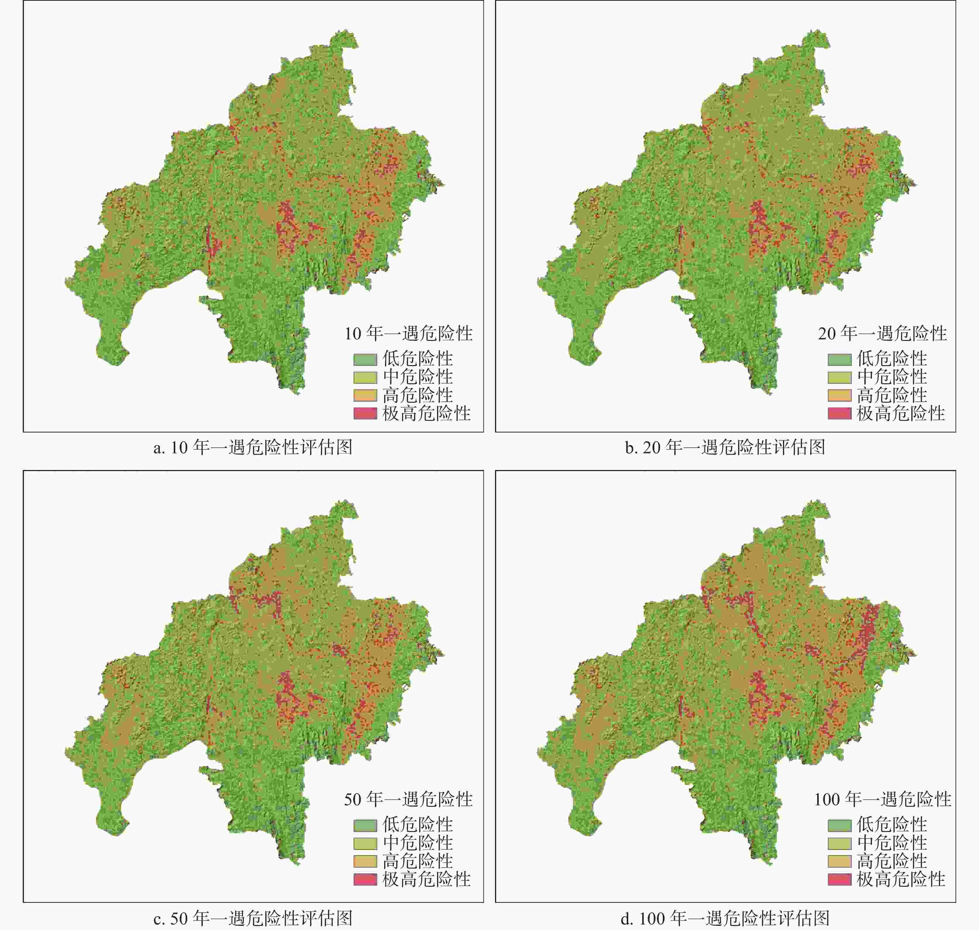
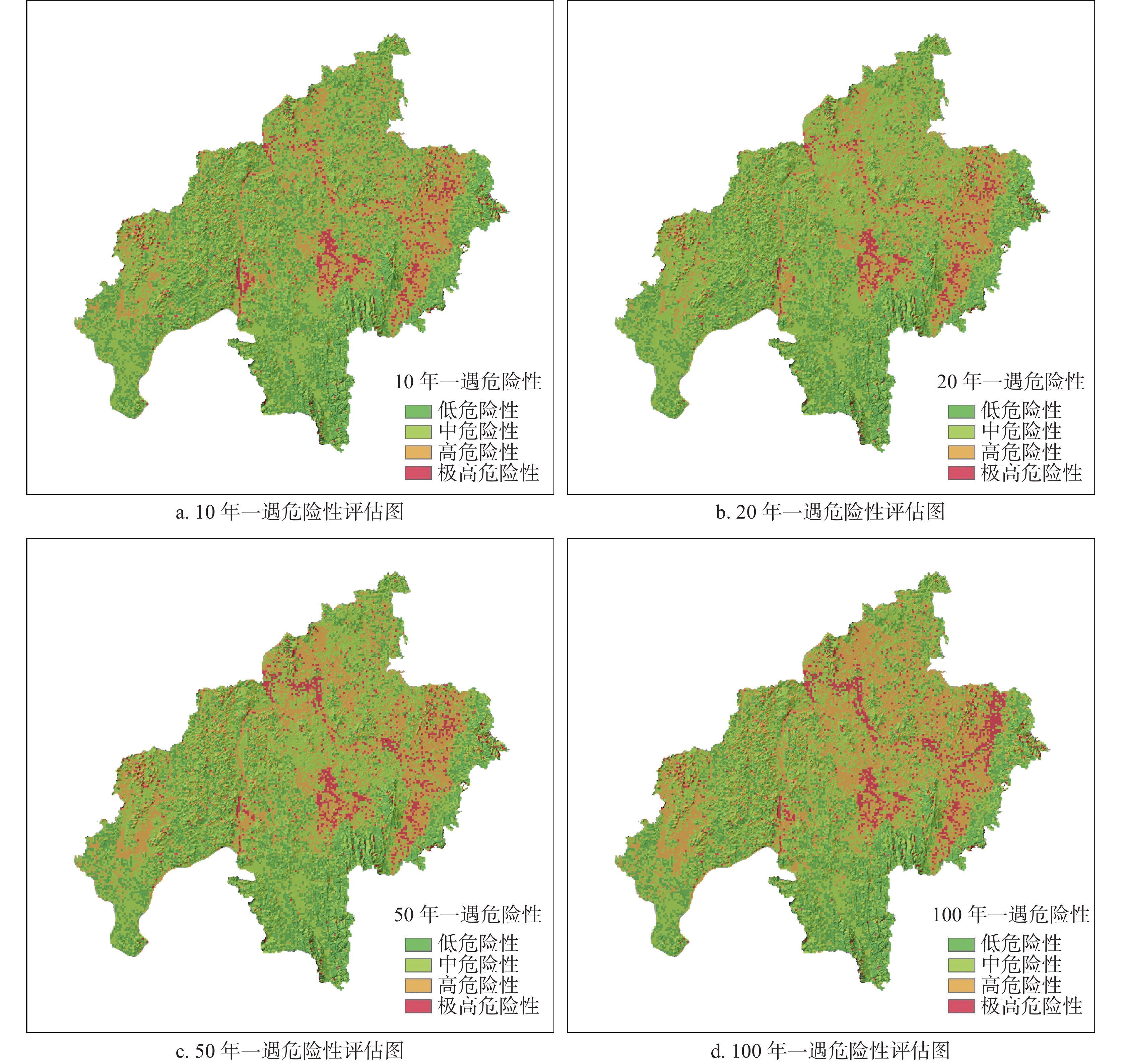
图 4 不同降雨重现期下地质灾害危险性评估图
Figure 4. Assessment for geological hazards under different return periods of rainfall conditions
表 1 地质灾害易发性评估因子信息量统计表
Table 1. Statistics of information quantity for assessment factors of geological hazard susceptibility
评估因子 状态 信息量值 权重 评估因子 状态 信息量值 权重 地形坡度 小于15° − 0.51757 0.2 植被覆盖度 低植被覆盖度 0.416139 0.1 15°~25° − 0.23831 较低植被覆盖度 0.25456 25°~45° 0.355834 中植被覆盖度 − 0.34393 大于45° 0.222174 高植被覆盖度 − 0.21632 工程地
质岩组薄-中厚层状较软砂岩、泥岩岩组(Ⅰ) − 0.62324 0.2 斜坡结构 顺向 1.109954 0.1 中厚层状中等岩溶化坚硬灰岩、白云岩夹
薄层状坚硬硅质岩、砂岩岩组(Ⅱ)− 0.31468 斜向 0.588141 厚层至块状强—中等岩溶化坚硬灰岩、
白云岩岩组(Ⅲ)0.32634 横向 − 0.09201 松散岩类砂砾石黏土双层土体(Ⅳ) 0.929235 逆向 − 0.35241 黏性土单层土体(Ⅴ) 0.285695 平地 0 地质构造 距离>2.5 km − 0.22223 0.1 地貌类型 丘陵 − 1.05437 0.1 距离1.5~≤2.5 km 0.142232 低山丘陵 − 0.25524 距离0.5~≤1.5 km − 0.01481 峰林谷地 0.326337 距离≤0.5 km 0.030636 残峰残丘平原 0.137501 河流阶地 0.912149 人类工
程活动弱 − 0.246851 0.1 岩溶发育程度 裸露型岩溶弱发育 − 0.08549 0.1 较弱 − 0.048627 覆盖型岩溶弱发育 − 0.13201 中等 0.186592 裸露型岩溶强发育 0.185539 强烈 0.268159 覆盖型岩溶强发育 0.246137 非岩溶区 0  下载: 导出CSV
表 2 象州县及周围地区各重现期下最大24 h降雨量值
Table 2. Maximum 24-hour rainfall value for each return period in Xiangzhou county and its surrounding areas
序号 站点名称 各重现期最大24 h降雨量/mm 10年 20年 50年 100年 1 象州 209.4 249.1 300.5 338.9 2 石龙 174.24 205.11 244.9 274.48 3 罗秀 191.47 231.53 283.06 321.31 4 中平 199.67 234.22 278.68 311.68 5 大樟 184.8 215.2 254.3 283.1 6 桐木 195.7 230.3 275 308.2 7 穿山 197.24 229.77 271.44 302.27 8 金鸡 154.6 176.35 203.83 223.95 9 六巷 206.45 240.5 284.11 316.38
下载: 导出CSV
表 3 不同降雨重现期下地质灾害危险性等级统计表
Table 3. Assessment for geological hazards under different return periods of rainfall conditions
降雨重现期 危险性等级 分布面积/km2 比例/% 10年一遇 低危险性 582.70 30.69 中危险性 891.93 46.98 高危险性 332.09 17.49 极高危险性 91.74 4.83 20年一遇 低危险性 501.14 26.40 中危险性 1025.37 47.69 高危险性 286.88 20.38 极高危险性 85.08 5.53 50年一遇 低危险性 480.77 25.32 中危险性 896.91 47.24 高危险性 415.85 21.90 极高危险性 104.93 5.53 100年一遇 低危险性 463.70 24.42 中危险性 806.34 42.47 高危险性 504.66 26.58 极高危险性 123.77 6.52
下载: 导出CSV
-
[1] 吕勇, 李高良, 张贵, 李继宏, 蔡传生, 稽仁元, 王外全. 彝良县地质灾害分布特征及防治建议[J]. 中国岩溶, 2009, 28(2): 219-224. doi: 10.3969/j.issn.1001-4810.2009.02.019LU Yong, LI Gaoliang, ZHANG Gui, LI Jihong, CAI Chuansheng, JI Renyuan, WANG Waiquan. Characteristics of the geological hazard distribution and the control measures in Yiliang county, Yunnan[J]. Carsologica Sinica, 2009, 28(2): 219-224. doi: 10.3969/j.issn.1001-4810.2009.02.019 [2] 刘孟宇, 邓辉, 张文江. 基于GIS和信息量模型的青海大通县地质灾害危险性定量评价分析[J]. 四川地质学报, 2021, 41(3): 494-499. doi: 10.3969/j.issn.1006-0995.2021.03.029LIU Mengyu, DENG Hui, ZHANG Wenjiang. Quantitative Risk Assessment of Geohazards in Datong, Qinghai Based on GIS and Information Quantity Model[J]. Acta Geologica Sichuan, 2021, 41(3): 494-499. doi: 10.3969/j.issn.1006-0995.2021.03.029 [3] 赖波, 刘佳, 江金进. 基于GIS的珠海市地质灾害易发性评价[J]. 地质灾害与环境保护, 2021, 32(1): 31-36. doi: 10.3969/j.issn.1006-4362.2021.01.005LAI Bo, LIU Jia, JIANG Jinjin. Evaluation of the susceptibility of geological disasters in ZHUHAI City based on GIS[J]. Journal of Geological Hazards and Environment Preservation, 2021, 32(1): 31-36. doi: 10.3969/j.issn.1006-4362.2021.01.005 [4] 魏风华. 河北省唐山市地质灾害风险区划研究[D]. 北京: 中国地质大学(北京), 2006.WEI Fenghua. Researches on geological hazard and risk zonation in Tangshan Hebei[D]. Beijing: China University of Geosciences (Beijing), 2006. [5] 殷跃平. 地质灾害风险调查评价方法与应用实践[J]. 中国地质灾害与防治学报, 2022, 33(4): 5-6. doi: 10.3969/j.issn.1003-8035.2022.4.zgdzzhyfzxb202204001Yin Yueping. Geological hazard risk investigation and evaluation method and application practice[J]. The Chinese Journal of Geological Hazard and Control, 2022, 33(4): 5-6. doi: 10.3969/j.issn.1003-8035.2022.4.zgdzzhyfzxb202204001 [6] 李信, 阮明, 杨峰, 柳长柱, 杨永鹏. 基于GIS技术和信息量法的地质灾害易发性研究以海南省昌江县为例[J]. 地质与资源, 2022, 31(1): 98-105.LI Xin, RUAN Ming, YANG Feng, LIU Changzhu, YANG Yongpeng. Evalution of geological hazard susceptibility based on GIS and information method: A case study of Changjiang County , Hainan Province [J]. Geology and Resources, 2022, 31(1): 98-105. [7] 马振, 谭光超, 季璇. 基于GIS的信息量法在九畹溪流域地质灾害易发性评价中的应用[J]. 资源环境与工程, 2021, 35(5): 667-680.Ma Zhen, Tan Guangchao, Ji Xuan. Application of Information Quantity Method Based on GIS inEvaluation of Geological Disasters Susceptibility in Jiuwanxi Basin[J]. Resources Environment & Engineering, 2021, 35(5): 667-680. [8] 王磊, 常鸣, 邢月龙. 基于信息量法模型与GIS的滑坡地质灾害风险性评价[J]. 地质灾害与环境保护, 2021, 32(2): 14-20. doi: 10.3969/j.issn.1006-4362.2021.02.003WANG Lei, CHANG Ming, XING Yuelong. Risk assessment of landslide geological hazards based on information method model and GIS[J]. Journal of Geological Hazards and Environment Preservation, 2021, 32(2): 14-20. doi: 10.3969/j.issn.1006-4362.2021.02.003 [9] 兰中孝, 郑冰, 廖德武, 张才兵, 王源, 潘世佳. 基于信息量法与斜坡单元的贵州省三都县打鱼镇地质灾害风险评价[J]. 地下水, 2023, 45(5): 160-163.LAN Zhongxiao, ZHENG Bing, LIAO Dewu, ZHANG Caibing, WANG Yuan, PAN Shijia. Risk assessment of geological disasters in Dayu town, Sandu county, Guizhou province based on information quantity method and slope unit[J]. Ground water, 2023, 45(5): 160-163. [10] 温金梅, 杨龙, 苟敬, 李德龙, 吴涛. 基于信息量法的地质灾害易发性评价: 以重庆市巫山县县城为例[J]. 地质与资源, 2021, 30(2): 193-198, 192.WEN Jinmei, YANG Long , GOU Jing, LI Delong, WU Tao. Evaluation of geohazard susceptibility based on information method: A Case Study of Wushan County in Chongqing Municipality[J]. Geology and Resources, 2021, 30(2): 193-198. [11] 王新伟, 张漓黎, 莫德科, 叶宗达, 江凡. 基于信息量和多层感知机分类器模型耦合的平果市斜坡类地质灾害易发性评价[J]. 中国岩溶, 2023, 42(2): 370-381. doi: 10.11932/karst20230208WANG Xinwei, ZHANG Lili, MO Deke, YE Zongda, JIANG Fan. Hillslope geo-hazard susceptibility assessment in Pingguo City based on coupling of CF information value and MLPC classifier model[J]. Carsologica Sinica, 2023, 42(2): 370-381. doi: 10.11932/karst20230208 [12] 牛树轩. 基于加权信息量法的西北黄土高原地质灾害易发性分区评价研究: 以延河流域为例[D]. 西安: 长安大学, 2014.Niu Shuxuan. The geological hazards sensitivity evaluation based on weighted information method: Case of the Yanhe River Basin[D]. Xi'an: Chang’an University, 2014. [13] 胡现振, 付少杰, 迟宏庆, 张辉军, 张志飞. 基于层次分析-信息量耦合模型的地质灾害风险评价: 以河北省武安市为例[J]. 中国地质调查, 2023, 10(5): 109-117.HU xianzhen, FU Shaojie, CHI Hongqing, ZHANG Huijun, ZHANG Zhifei. Geological hazard risk assessment based on AHP-information coupling model: A case study of Wu'an City in Hebei Province[J]. Geological Survey of China, 2023, 10(5): 109-117. -

 点击查看大图
计量
- 文章访问数: 2089
- HTML浏览量: 835
- PDF下载量: 89
- 被引次数: 0
