

Analysis of the influence of tunnel engineering on groundwater resources in karst mountain areas: A case study of a tunnel in Wushan county of Chongqing City
-
摘要: 隧道工程建设可破坏施工区的地下水平衡,引发地下水疏降以及其他生态环境问题。文章以某引水隧道为研究对象,基于隧道周边水库蓄水量明显减少的问题,采用水文地质调查、示踪试验等方法,查明补径排条件变化特征,分析引水隧道工程与周边地下水之间的水力联系及其对周边水库蓄水量变化的影响。引水隧道施工过程中,周边3 km范围内有12处泉点呈疏干或半疏干状态,且隧道南西侧泉点受影响程度较北西侧小。基于解析法计算可知引水隧道开挖后对地表水及地下水的影响半径范围为649~
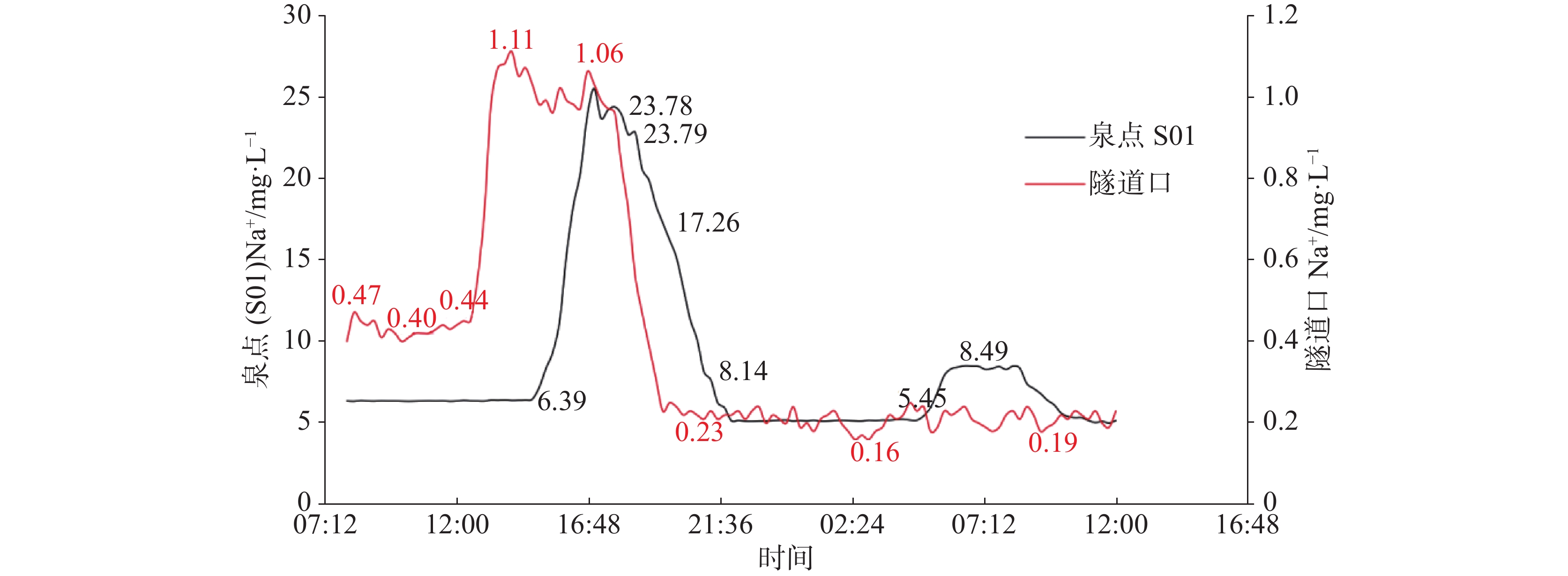
2073 m,影响面积为13.7 km2,与水库集水范围重叠面积为4.02 km2。野外示踪试验结果表明引水隧道上部地表落水洞与引水隧道排水口、部分泉点之间存在密切的水力联系,水库的部分补给水源改向隧道口径流和排泄,致使水库蓄水量减少。研究结果表明引水隧道工程建设改变了周边地下水补径排条件,从而导致水库水源不足,蓄水量减少,影响了城市居民供水。Abstract:Tunnel construction can disrupt the groundwater balance, impacting the drainage of both surface water and groundwater, as well as causing other eco-environmental effects. This study takes a water-diversion tunnel as the research object. Prompted by a pronounced decline in the storage of the adjacent reservoir of the tunnel, it integrates hydrogeological surveying and tracer tests to characterize the altered recharge–flow–discharge conditions, elucidate the hydraulic interactions between the tunnel and the surrounding groundwater system, and quantitatively evaluate the tunnel’s impact on the observed reservoir-storage variations. Field investigations indicate that groundwater in the study area can be divided into three categories: karst water from carbonate rock fissures, karst water from fissures characterized by carbonate rock interbedded with clastic rock, and karst water from pores and fissures characterized by mudstone interbedded with silty mudstone. The water bearing formations of karst water from carbonate rock fissures consist of the Lower Triassic Jialingjiang Formation (T1j) and the Daye Formation (T1d3+4) along the axis and wings of an anticline. These units exhibit significant water abundance and are well developed with karst landforms, such as karst depressions, sinkholes, caves, and underground rivers. Karst water from fissures characterized by carbonate rock interbedded with clastic rock occurs within the first and third members of the Middle Triassic Badong Formation (T2b1+3) along the axis and wings of a syncline. The water abundance of the formation is moderate, and karst features are only locally developed. Karst water from pores and fissures characterized by mudstone interbedded with silty mudstone is primarily stored in the second member of the Middle Triassic Badong Formation (T2b2) and exhibits comparatively low water abundance. Groundwater recharge is derived primarily from atmospheric precipitation and surface water bodies such as reservoirs and fish ponds. Due to the large terrain cutting, the speed of surface water runoff is fast. The catchment of the reservoir is located west of the axis of the water-diversion tunnel on the southeast wing of the anticline. Exposed strata comprise limestone, dolomitic limestone, dolomite, and rock-solution breccia of T1j and T1d3+4, as well as limestone, argillaceous limestone, argillaceous dolomite, and mudstone of T2b. Within the Jialingjiang and Daye Formations, sinkholes, depressions, and dissolution fissures are well developed, facilitating efficient infiltration of rainwater through karst conduits to the saturated zone. Although karst development is weak in the Badong Formation, secondary structures have intensely fractured the rock mass; rainwater recharge, therefore, occurs dominantly through fissures. Overall, the catchment exhibits favorable groundwater recharge conditions. After infiltration, groundwater migrates southwestward along either longitudinal karst conduits or fissure networks. The deeply cut watercourse in which the reservoir is located, along with the dense network of tributary gullies, ultimately leads to the discharges of groundwater in the form of karst springs within these gullies. The water-diversion tunnel crosses the anticline, traversing limestone and dolomite of T1d and T1j, with T1j serving as the principal aquifer. The anticlinal axis functions as a watershed, resulting in the southern and northern segments of the tunnel each forming an independent groundwater system. The tunnel site is deeply cut, resulting in poor recharge conditions. Scattered precipitation accumulates only within the upper narrow peak-cluster depressions, subsequently infiltrating vertically along sinkholes. Southwest of the tunnel, the reservoir catchment consists of T1j, T1d, and T2b formations, which are characterized by well-developed sinkholes, karst depressions, and corrosion fissures that create favorable discharge conditions. Following rainfall events, groundwater is directed southwestward along longitudinally oriented karst conduits. These conduits are cut by gullies, where groundwater ultimately discharges as karst springs. Before the construction of the water-diversion tunnel, atmospheric precipitation infiltrated through surface karst depressions, sinkholes, dolines, or corrosion fissures to recharge groundwater. Afterward, a portion of the precipitation flowed through the aquifer and discharged in the form of an underground river along the riverbank. Another portion of flowed through the runoff that crossed fissures perpendicular to the structural trend, and discharged in the form of karst springs (including the S01 spring point) or underground rivers within the gully and watercourse that cut the south-eastern wing of the anticline. The spring points exposed in the gully and watercourse were the main source of water supply for the reservoir. Because the water-diversion tunnel intersected the transition zone between the vertical and horizontal circulation cells of the karst aquifer, its excavation repeatedly intersected underground rivers and cave systems. Severe water inflows were encountered, resulting in twelve springs within a 3-km radius becoming either completely or partially dewatered. Springs located to the southwest of the tunnel were less affected than those to the northwest. Analytical calculations indicate that the influence radius of the water-diversion tunnel on surface water and groundwater extends from 649 to 2,073 m, covering 13.7 km2. The overlapping area of the reservoir catchment is 4.02 km2. Tracer tests confirm a strong hydraulic connection between the surface sinkholes located above the tunnel, and the drainage outlet of the water-diversion tunnel and several spring points. Consequently, a portion of the reservoir’s recharge has been diverted to runoff at the tunnel exit and subsequently discharged, thereby reducing the storage capacity of the reservoir. The findings demonstrate that the alteration of regional groundwater recharge–flow–discharge conditions induced by the tunnel project is the primary cause of the observed decline in groundwater-derived inflow to the nearby reservoir. -
Key words:
- tunnel projects /
- groundwater /
- storage capacity of the reservoir /
- influence /
- tracer test
-
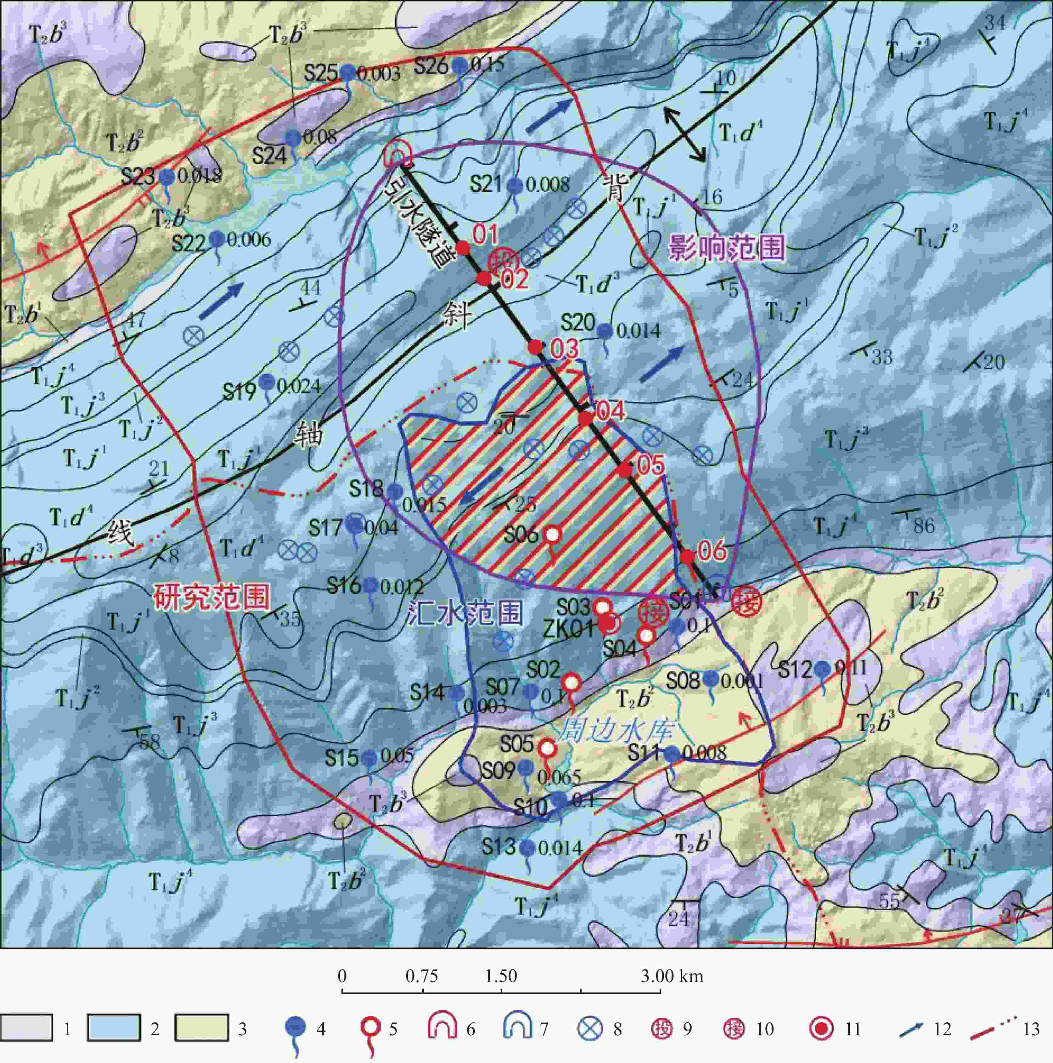
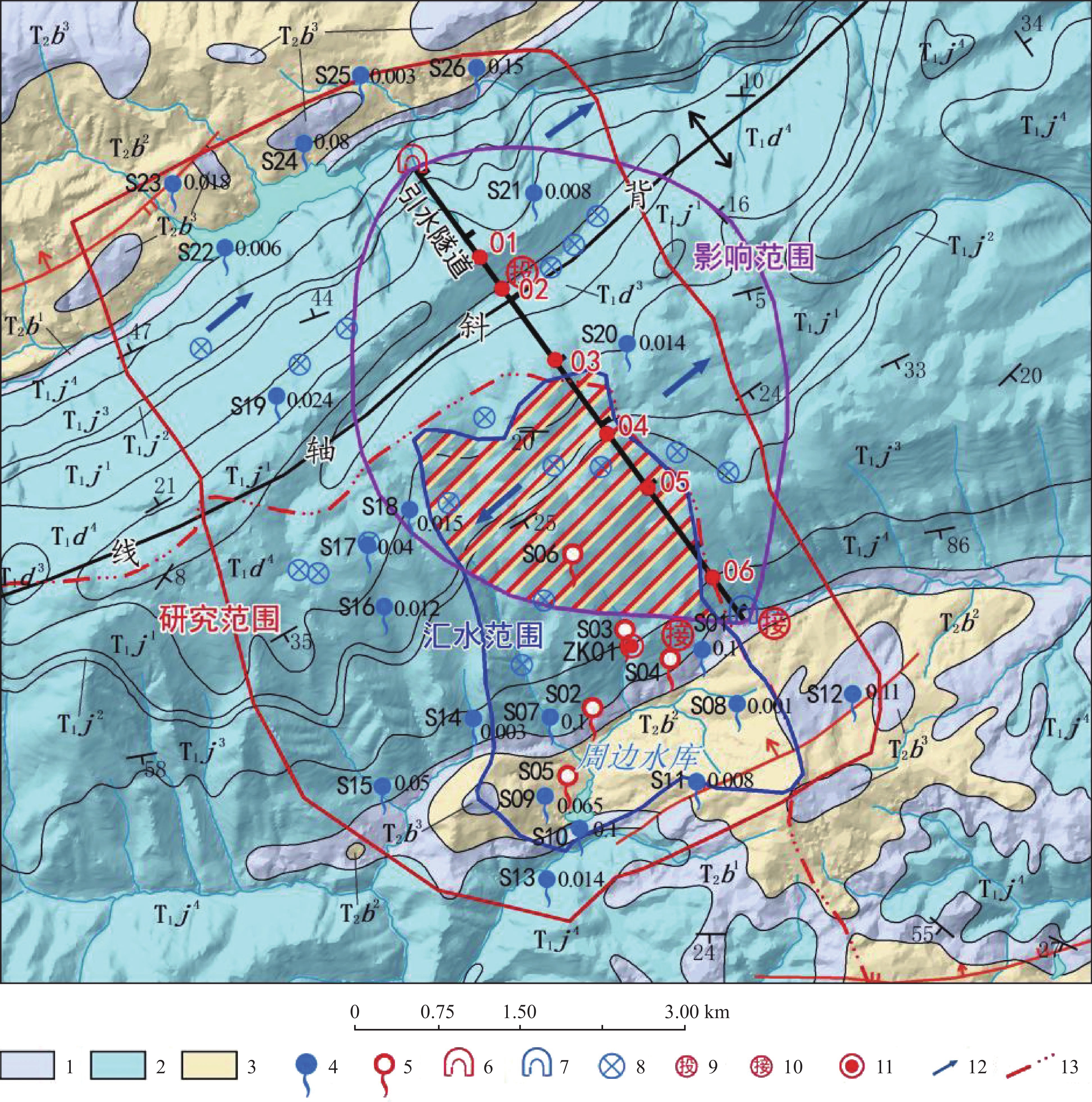
图 2 研究区水文地质图
T1d1-4.三叠系下统大冶组1-4段 T1J1-4.三叠系下统嘉陵江组1-4段 T2b1-4.三叠系中统巴东组1-4段 1.碳酸盐岩裂隙溶洞水 2.碳酸盐岩夹碎屑岩裂隙溶洞水 3.泥页岩夹粉砂质泥岩孔隙裂隙水 4.泉点(左编号,右流量L·s−1) 5.疏干泉 6.无水隧道口 7.有水隧道口 8.落水洞 9.示踪剂投放点 10.示踪剂接收点 11.水文地质钻孔 12.地下水流向 13.分水岭
Figure 2. Hydrogeological map of the study area
T1d1-4.Members 1-4 of the Daye Formation of the Lower Triassic Series T1J1-4.Members 1-4 of the Jialingjiang Formation of the Lower Triassic Series T2b1-4.Members 1-4 of the Badong Formation of the Middle Triassic Series 1. karst water from carbonate rock fissures 2. karst water from fissures characterized by carbonate rock interbedded with clastic rock 3. karst water from pores and fissures characterized by mudstone interbedded with siltstone 4. spring points (left: number; right: flow L·s−1) 5. draining spring 6. waterless tunnel entrance 7. watery tunnel entrance 8. sinkhole 9. tracer injection point 10. tracer receiving point 11. hydrogeological borehole 12. direction of groundwater flow 13. watershed.
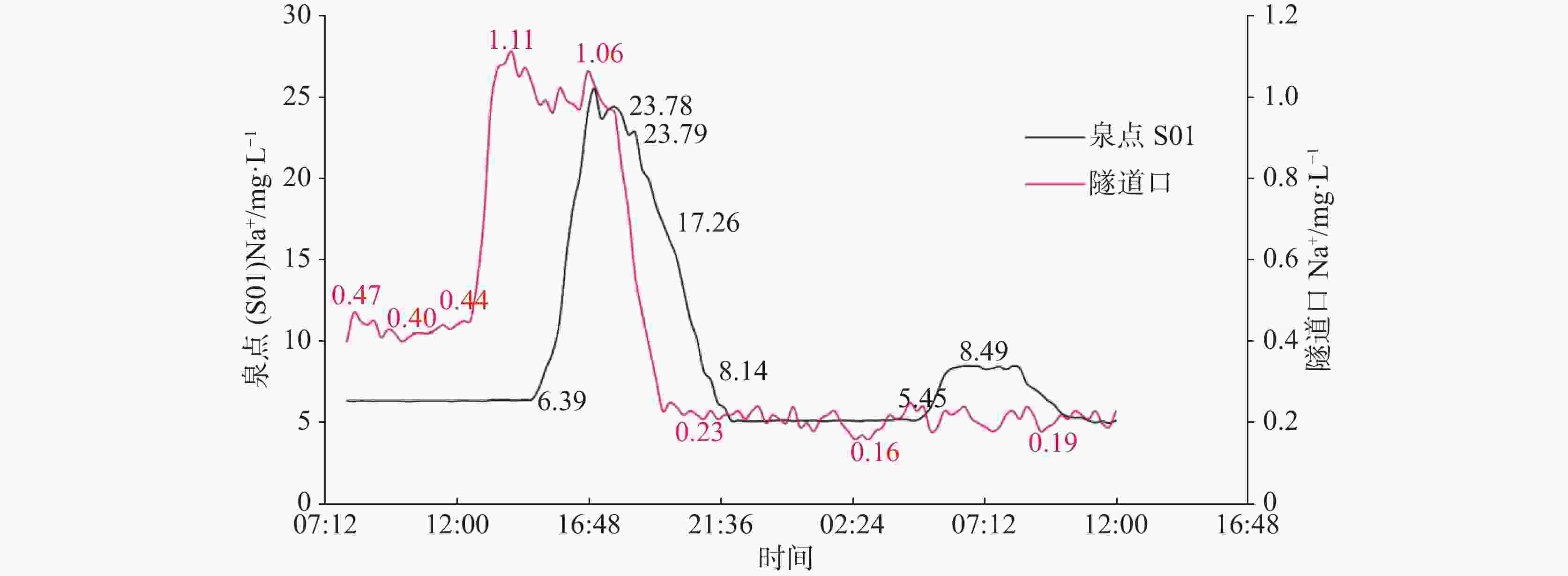
图 4 引水隧道口和泉点S01的Na+浓度历时变化曲线图
Figure 4. Variation curves of the concentration of Na+ at the tunnel exit and the spring S01
表 1 水库补给源泉点水资源调查情况统计表
Table 1. Statistics of water resource investigation of the spring recharge for the reservoir
泉点编号 地层 施工前调查
流量/L·s−1施工后调查时
流量/L·s−1动态特征 目前利用情况 疏降情况 S01 T2b1 1.00~5.00 0.50 常年不干,枯丰季流量变化幅度1~5倍,暴雨可增至10倍 供附近10余户居民
作生活用水半疏干 S02 T2b1 1.00~10.00 0 隧道修通后完全断流 未利用 疏干 S03 T1j4 0.05~0.50 0 隧道修通后完全断流 未利用 疏干 S04 T1j4 1.00~3.00 0 季节性泉,隧道修建后完全断流 未利用 疏干 S05 T2b2 0.10~1.00 0 原常年有水,隧道修建后
完全断流未利用 疏干 S06 T1j3 0.10~0.50 0 季节性泉,隧道修通后
完全断流平时无人利用,有水时供附近2~3户人作生活用水 疏干 S07 T1j4 0.50~2.00 0.10 常年不干,枯丰季流量变化幅度1~10倍,暴雨可增至50倍 研究区水库的主要地下水来源之一,供周边3~5户人作生活用水及灌溉用水 半疏干 S08 T2b2 0.01~0.05 0.001 常年不干,枯丰季流量变化幅度1~3倍,暴雨可增至5倍 供附近1~2户人作生活用水 半疏干 S09 T2b2 0.02~0.10 0.065 常年不干,枯丰季流量变化幅度1~3倍,暴雨可增至5倍 供附近5~8户人作生活用水 无影响 S10 T2b2 0.10~1.00 0.10 常年不干,枯丰季流量变化幅度1~5倍,暴雨可增至10倍 淹没于水库之下,为水库的
主要地下水补给源之一无影响  下载: 导出CSV
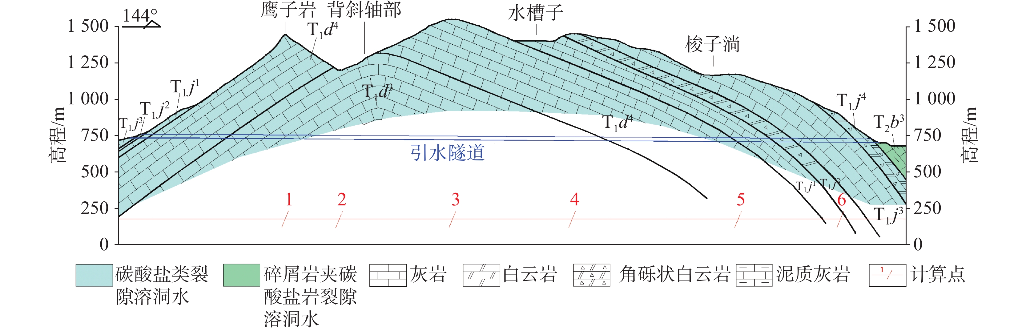
表 2 引水隧道对周边地下水的影响范围计算结果
Table 2. Calculation results of the influence range of the water-diversion tunnel on the surrounding groundwater
计算点 地层 岩性 渗透系数/m·d−1 含水层厚度/m 给水度 降水补给强度/m·d−1 时间/d 影响半径/m 1 T1d3 灰泥灰岩 0.038 730 0.09 0.003 3559 1450 2 T1d3 灰泥灰岩 490 1079 3 T1d3 灰泥灰岩 0.065 830 2073 4 T1d4 灰岩 760 1951 5 T1j1 灰岩 600 1646 6 T1j3 灰岩 200 649
下载: 导出CSV
-
[1] 张竹清. 生态保护区地下水环境受隧道开挖影响敏感性评价[J/OL]. 铁道标准设计, 1-10[2400-04-09].ZHANG Zhuqing. Sensitivity assessment of groundwater environment affected by tunnel excavation in ecological protection areas[J/OL]. Railway Standard Design, 1-10[2400-04-09]. [2] LIU Jinquan, CHEN Weizhong, LIU Taogen, YU Jianxin, DONG Jingliang, NIE Wen. Effects of initial porosity and water pressure on seepage-erosion properties of water inrush in completely weathered granite[J]. Geofluids, 2018, 1-11. [3] ZHANG Guohua, WANG Chengtang, JIAO Yuyong, WANG Hao, CHEN Libiao. Deposits sources of inrush hazards for the liangshan tunnel passing through deeply buried granite[J]. Tunnelling and underground space technology, 2019, 92(Oct.): 103058.1-103058.15. [4] 潘以恒. 风化花岗岩隧道矿山法施工对地下水环境影响研究[D]. 武汉: 中国地质大学(武汉), 2018.PAN Yiheng. Research on influence of tunnel construction with mining method on groundwater environment in weathered granite[D]. Wuhan: China University of Geosciences(Wuhan), 2018. [5] Ii H, Kagami H. Groundwater level and chemistry changes resulting from tunnel construction near Matsumoto City, Japan[J]. Environmental Geology, 1997, 31(1-2): 76-84. doi: 10.1007/s002540050166 [6] Goodman R E, Moye D G, Van Schalkwyk A , Javandel I. Groundwater Inflows During Tunnel Driving[J]. Engineering Geology, 1965, 1(1): 39-56. [7] Marechal J C, Perrochet P. New analvtical solution for the study of hydraulic intercaction between Alpine tunnels and groundwater[J]. Bulletin De La Societe Geologique De France, 2003, 174(5): 441-448. doi: 10.2113/174.5.441 [8] 张玉强,张国柱,夏才初,杨勇. 利用地温能的隧道保温加热水沟技术经济分析[J]. 西部交通科技, 2015, 90(1): 22-27.ZHANG Yuqiang, ZHANG Guozhu, XIA Caichu, YANG Yong. Technical and economic analysis of tunnel insulation and heating ditch by using the geothermal energy[J]. Western China Communications Science & Technology, 2015, 90(1): 22-27. [9] 白明洲, 许兆义, 王连俊, 王勐. 复杂岩溶地区隧道施工突水地质灾害研究[J]. 中国安全科学学报, 2006, 16(1): 114-118.BAI Mingzhou, XU Zhaoyi, WANG Lianjun, WANG Meng. Study on water outburst geological disaster of tunnel construction at complicated karst zone[J]. Chinese Journal of Safety Science, 2006, 16(1): 114-118. [10] 康小兵, 罗声, 许模, 刘宏. 华蓥山中段地区地下水资源量评价[J]. 中国岩溶, 2018, 37(4): 527-534.KANG Xiaobing, LUO Sheng, XU Mo, LIU Hong. Evaluation of groundwater resource loss in middle regions of Huaying mountain[J]. Carsologica Sinica, 2018, 37(4): 527-534. [11] 祝军. 隧道工程对云雾山岩溶地区地质环境的影响[J]. 资源环境与工程, 2013, 27(6): 776-781.ZHU Jun. The effect of tunneling engineering on geological environment in yunwushan karst area[J]. Resources Environment and Engineering, 2013, 27(6): 776-781. [12] 邓清海, 马凤山, 袁仁茂, 李国庆, 赵海军. 石太客运专线特长隧道地区水文地质研究及隧道开挖环境影响效应[J]. 第四纪研究, 2006, 26(1): 136-143.DENG Qinghai, MA Fengshan, YUAN Renmao, LI Guoqing, ZHAO Haijun. The hydrogeological and environmental effectst of the excavation of the extra-long tunnel of the Shitai passenger dedicated railway[J]. Quaternary Research, 2006, 26(1): 136-143. [13] 曹锐, 吕玉香, 裴建国. 南川黄泥垭隧道工程对水文地质条件的影响分析[J]. 中国岩溶, 2017, 36(5): 691-696.CAO Rui, LYU Yuxiang, PEI Jianguo. Analysis on the hydrogeological influence of Huangniya tunnel[J]. Carsologica Sinica, 2017, 36(5): 691-696. [14] Gi-Tak Chae, Seong-Taek Yun, Byoung-Young Choi, Soon-Young Yu, Ho-Young Jo, Bernhard Mayer, Yun-Jong Kim, Jin-Yong Lee. Hydrochemistry of urban groundwater, Seoul. Korea: The impact of subway tunnels on groundwater quality[J]. Journal of Contaminant Hydrology, 2008, 101(1-4): 42-52. doi: 10.1016/j.jconhyd.2008.07.008 [15] 中华人民共和国环境保护部. 环境影响评价技术导则: 地下水环境[M]. 北京: 中国环境科学出版社, 2016.Ministry of Environmental Protection of the People's Republic of China. Technical guidelines for environmental impact assessment-groundwater environment [M]. Beijing: China Environmental Science Press, 2016. [16] 张浪, 李俊, 潘晓东, 黄晓荣, 彭聪. 西南某岩溶区地下水系统示踪试验与解析[J]. 中国岩溶, 2020, 39(1): 42-47.ZHANG Lang, LI Jun, PAN Xiaodong, HUANG Xiaorong, PENG Cong. Tracer test and analysis of groundwater system in a karst area of southwest China[J]. Carsologica Sinica, 2020, 39(1): 42-47. [17] 姚莎莎, 张毅, 王新文, 李先恒, 许江坤, 郭发贵, 蒙彦. 运用示踪试验分析隧道和岩溶泉的水力联系及介质特征: 以关山隧道为例[J]. 中国岩溶, 2024, 43(1): 25-32.YAO Shasha, ZHANG Yi, WANG Xinwen, LI Xianheng, XU Jiangkun, GUO Fagui, MENG Yan. Analysis on the hydraulic connection and medium characteristics between tunnels and karst springs by tracer tests: A case study of Guanshan tunnel[J]. Carsologica Sinica, 2024, 43(1): 25-32. [18] Benischke R. Review: Advances in the methodology and application of tracing in karst aquifers[J]. Hydrogeology journal, 2021, 29(1): 67-88. doi: 10.1007/s10040-020-02278-9 [19] 刘天云, 罗锐恒, 胡顺强, 赵永宾, 潘晓东, 刘伟. 文山小河尾水库岩溶渗漏水文地质条件与管道位置识别[J]. 中国岩溶, 2022, 41(1): 88-99.LIU Tianyun, LUO Ruiheng, HU Shunqiang, ZHAO Yongbin, PAN Xiaodong, LIU Wei. Hydrogeological conditions of karst leakage and identification of pipeline location in Xiaohewei reservoir, Wenshan[J]. Carsologica Sinica, 2022, 41(1): 88-99. -

 点击查看大图
计量
- 文章访问数: 1051
- HTML浏览量: 615
- PDF下载量: 113
- 被引次数: 0
