

Analysis of characteristics and controlling factors of underground river pipeline based on tracer tests and fracture measurement: Take the Luohandu underground river as an example
-
摘要: 中国西南地区岩溶发育十分显著,目前已探明的岩溶地下河达
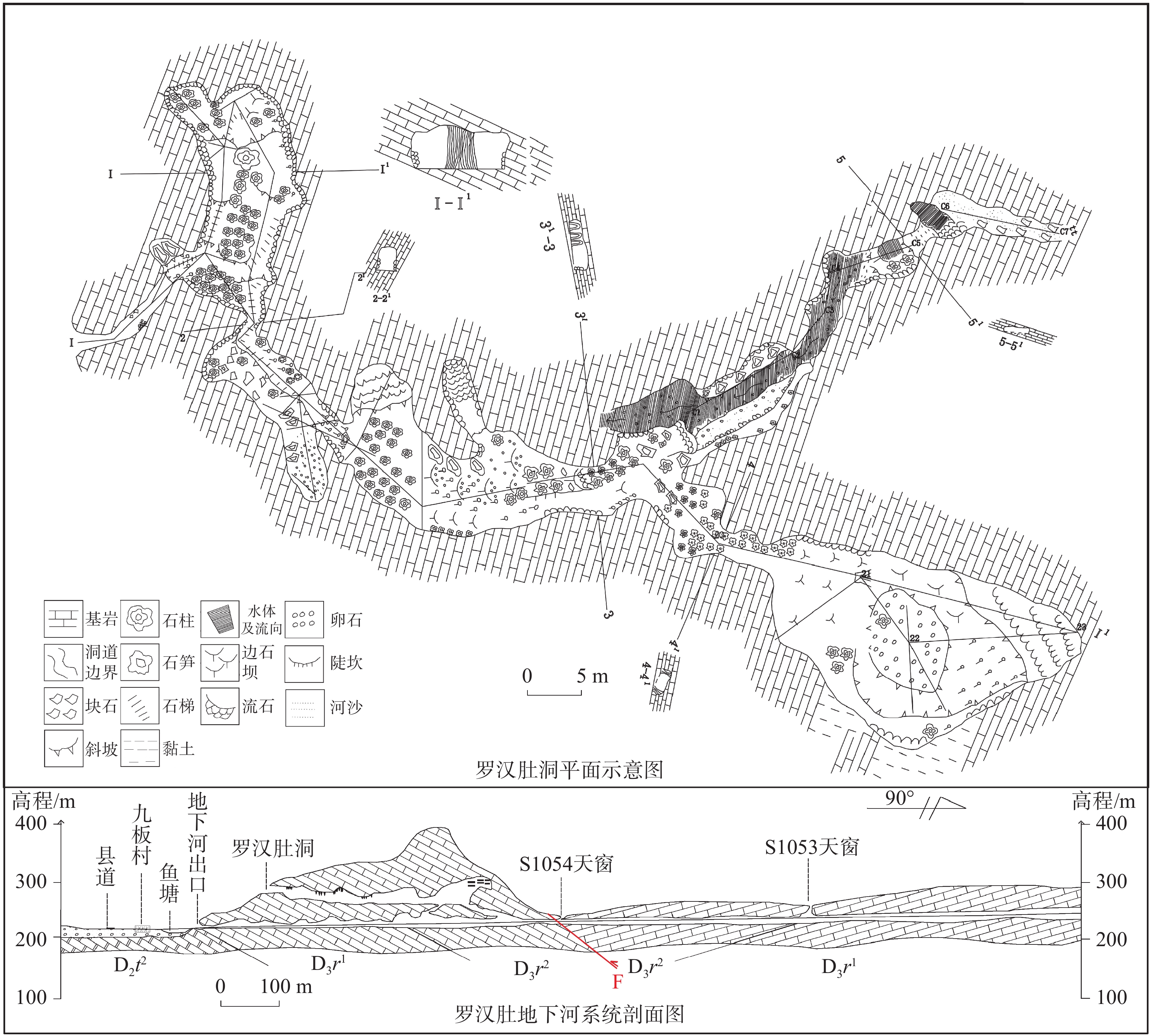
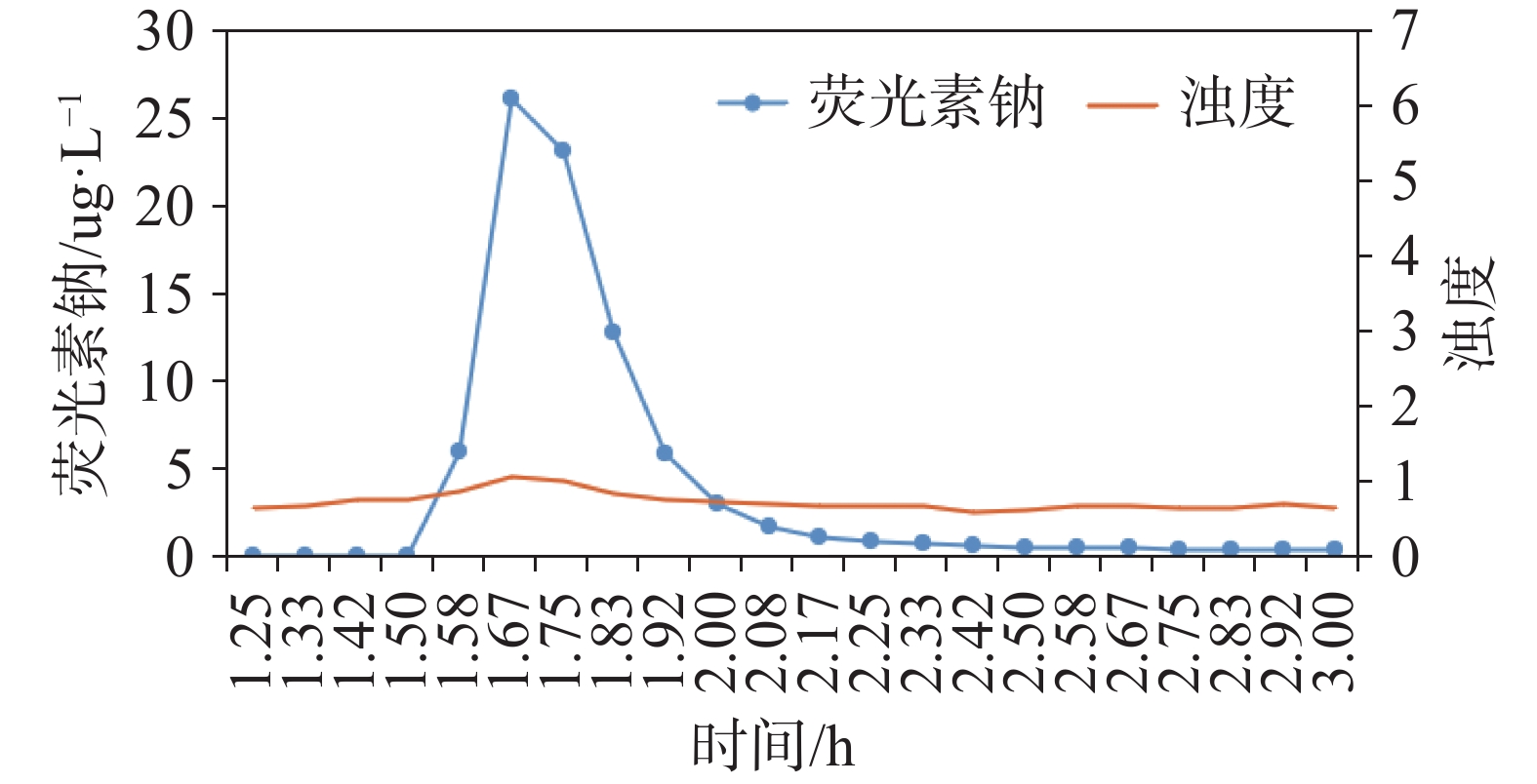
3066 条,岩溶管道的展布特征及其发育控制因素的研究具有重要意义。文章以恭城县罗汉肚地下河为研究对象,在区域构造条件分析和洞穴探测的基础上,通过高精度定量示踪试验的曲线特征分析,明确了罗汉肚地下河为单一管道形态。同时,采用统计窗口法对四组裂隙进行了测量,研究发现,第1组和第4组裂隙的走向与地下河的发育方向基本一致。研究表明,高角度构造裂隙为地下河的补给提供了重要通道。通过计算构造裂隙渗透张量主值,发现5个测量点的渗透张量主值K3的倾向范围为254°至292°,倾角多小于25°。最大渗透张量的方向决定了岩溶地下水的渗流方向,进而控制了地下河管道的发育。文章通过多种技术手段,系统掌握了地下河管道的展布特征,揭示了地下河形成的控制因素。Abstract:The karst development in Southwest China is very remarkable. At present, 3,066 karst underground rivers have been identified. As the main reservoir of groundwater resources, studying the distribution characteristics and controlling factors of karst pipelines is of great importance. In this study, the Luohandu underground river in Gongcheng county was selected as the research object, and a 1: 50,000-scale hydrogeological survey was carried out. It was found that an upper karst cave exists at the outlet of the Luohandu Underground River, which is supposed to be the original discharge outlet. The karst cave measures 567.9 m in length, and investigations revealed that the pipeline of the lower underground river extends about 1.6 km. Based on regional geological data, the Luohandu underground river is located near the structural belt formed by Limu–Heping fault and the Jiahui translational fault. The Limu–Heping fault trends north–south, while the Jiahui translational fault trends east-west direction. The Limu–Heping fault intersects the study area, and its structure controls the development of underground river pipelines. To identify the controlling factors of pipeline development, groundwater tracer tests and fracture measurement were conducted. The tracer was introduced into the skylight of the underground river in its upper reaches, and the tracer was detected after only 1.5 hours. The tracer concentration peaked at 1.7 hours and then began to decline. It was calculated that the maximum velocity of groundwater between the skylight and the outlet of the underground river was 550.4 m·h−1, with an average velocity of 447.7 m·h−1. These results showed that the groundwater flow between the skylight and the outlet of the underground river is closely connected, the migration path is relatively smooth, and the karst has been developed in the form of a single pipe. At the same time, four groups of fractures were measured by statistical window method, including three groups of structural fractures and one group of bedding fractures. To investigate the influence of fractures on the development of karst pipelines, the statistical analysis of fractures measurements revealed that the direction of the first and fourth fracture groups are generally consistent with the development direction of the underground river. Further analysis showed that high-angle structural fractures provide important channels for groundwater recharge into underground rivers. By calculating the principal values of permeability tensor for the structural fractures, it was found that the dip directions of the third principal permeability tensor (K3) at five measurement points ranged from 254° to 292°, with dip angles mostly less than 25°. The direction of maximum permeability governs the seepage direction of karst groundwater, and long-term erosion and dissolution along this direction ultimately control the development of the underground river pipilines. Based on a 1:50,000-scale hydrogeological survey and regional geological data, this study examines the structural patterns and provides a detailed description of the distribution and spatial characteristics of underground river pipelines using high-precision tracer tests. It also analyzes the influence of structural fractures on these underground river pipelines by combining fracture measurements with permeability tensor calculations. Through various technical approaches, this study not only systematically characterizes the distribution characteristics of underground river pipelines but also reveals the controlling factors in their formation, thereby providing an important scientific foundation for subsequent investigations of underground rivers and water resource evaluation. -
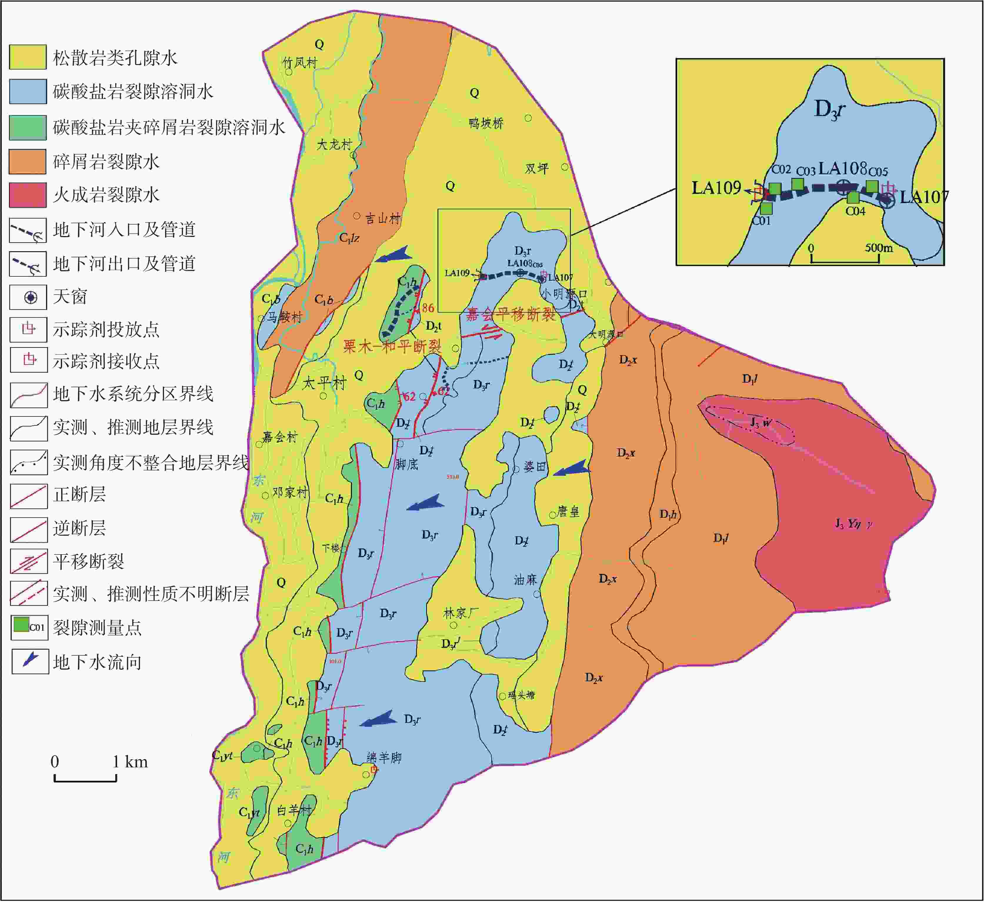
图 1 罗汉肚地下流域河水文地质简图
Figure 1. Hydrogeological sketch of the Luohandu underground river basin
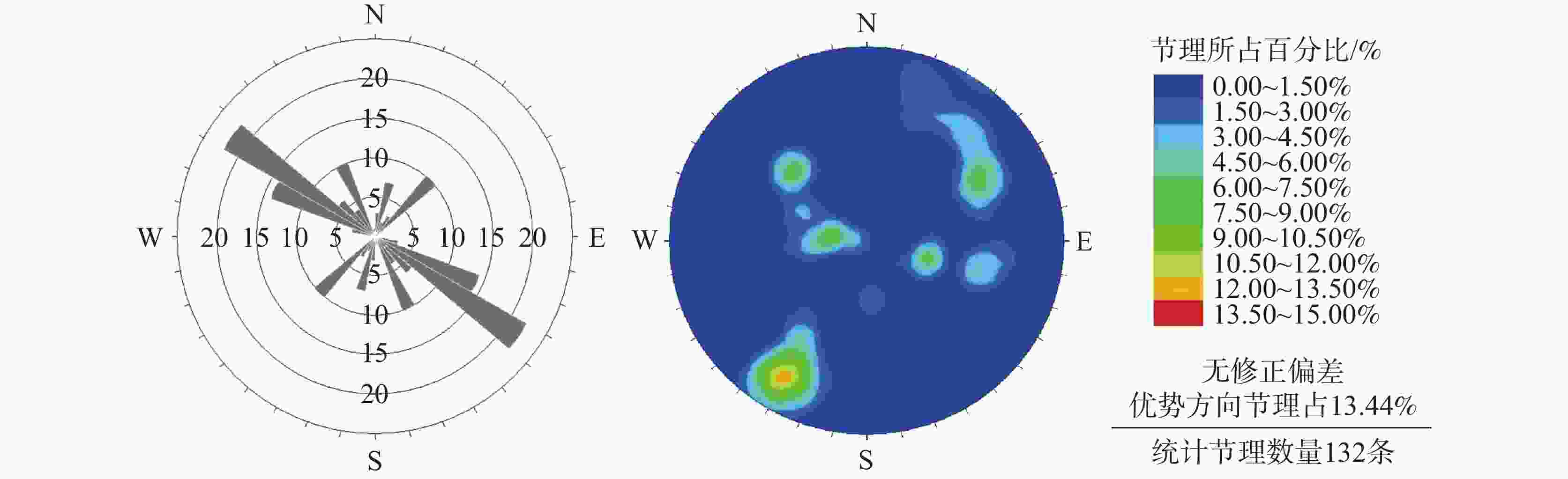
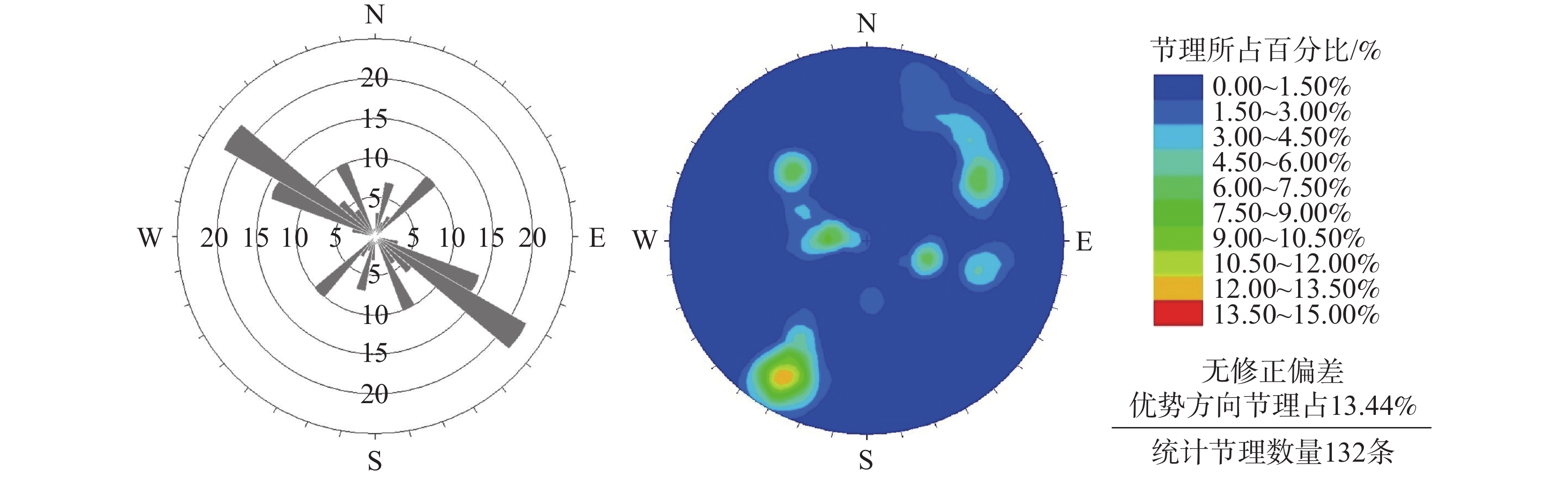
图 4 融县组地层走向玫瑰花图和等密度图
Figure 4. Rose diagram and isodensity diagram of strata strike of Rongxian Formation
表 1 示踪试验部署情况
Table 1. Deployment of tracer tests
投放地点 至出口距离L/m 投放时间 示踪剂种类 注入方式 投放量M/g LA107天窗 1097 2022-05-30 11:50 荧光素钠 一次性注入 15  下载: 导出CSV
表 2 罗汉肚地下河示踪段水力参数
Table 2. Hydraulic parameters of the tracing section of the Luohandu underground river
示踪间段 P/% T/h V/m3 A/m2 DC/m DL/m NR LA107-LA109 72.05 29.01 10445 6.5078 2.8785 2570.7 35631
下载: 导出CSV
表 3 罗汉肚地下河发育地层主要裂隙发育情况
Table 3. Development of main fractures in the development strata of the Luohandu underground river
裂隙分组 产状 延伸长度/m 隙宽/mm 线密度/
条·m−1结构面类型 充填情况 倾向 倾角 1 20°~40° 45°~80° 1.5~2 0.20~0.75 8 构造裂隙 泥质填充 2 80°~148° 14°~58° >2 0.05~0.68 12 层面裂隙 无填充 3 192°~265° 40°~83° >2 0.05~1.20 10 构造裂隙 无填充 4 273°~359° 32°~73° >2 0.05~1.10 8 构造裂隙 无填充
下载: 导出CSV
表 4 罗汉肚地下河裂隙测量渗透张量计算结果
Table 4. Calculation results of permeability tensor in fracture measurement of the Luohandu underground river
测量点 渗透张量/m·d−1 渗透主值/m·d−1 渗透主值方向 综合渗透系数
K0/m∙d−1倾向 倾角 C01 1.9315 − 0.1869 − 0.1050 0.648 61.2° 84.2 1.206 − 0.1869 1.4104 − 0.0207 1.354 162.8° 4.2° − 0.1050 − 0.0207 0.6582 1.998 287.5° 4.0° C02 − 0.1863 − 0.9732 − 0.1350 1.540 10.8° 7.8° 1.949 0.3091 0.0724 − 0.9483 1.819 256.8° 71.5° 0.9326 − 0.2184 0.2874 2.641 283.2° 16.7° C03 2.6695 − 0.4385 0.2672 1.429 231.7° 10.8° 1.905 − 0.4385 1.8306 − 0.0361 1.666 19.1° 75.0° 0.2672 − 0.0361 1.4999 2.905 292.5° 10.4° C04 2.0564 0.7778 − 0.0377 1.247 316.5° 10.8° 1.890 0.7778 2.0391 − 0.2081 1.896 91.5° 75.0° − 0.0377 − 0.2081 1.9045 2.857 254.5° 10.4° C05 1.3275 0.4047 − 0.1757 0.783 345.2° 55.1° 1.220 0.4047 1.5992 − 0.4779 1.094 111.1° 22.2° − 0.1757 − 0.4779 1.0733 2.123 272.3° 25.4° 注:表中渗透主值从上往下依次为K1、K2、K3,其中K3代表最大渗透张量主值方向。
下载: 导出CSV
-
[1] 蒲俊兵. 重庆地区岩溶地下河发育与分布的基本特征[J]. 中国岩溶, 2013, 32(3): 266-279.PU Junbing. Development and distribution of karst subterranean streams in Chongqing, China[J]. Carsologica Sinica, 2013, 32(3): 266-279. [2] 宋晨, 潘晓东, 刘天云, 罗飞, 曾洁, 彭聪, 程瑞瑞, 张文平. 云南省一把伞水库主封堵区岩溶渗漏条件与管道特征分析.[J]. 中国岩溶, 2024, 43(5): 1088-1098. doi: 10.11932/karst2024y033SONG Chen, PAN Xiaodong, LIU Yuntian, LUO Fei, ZENG Jie, PENG Cong, CHENG Ruirui, ZHANG Wenping. Analysis of karst leakage conditions and pipeline characteristics in the main blocked area of Yibasan reservoir, Yunnan.[J]. Carsologica Sinica, 2024, 43(5): 1088-1098. doi: 10.11932/karst2024y033 [3] 袁丙华. 中国西南岩溶石山地区地下水资源及生态环境地质研究[M]. 成都: 电子科技大学出版社, 2007.YUAN Binghua . Study on groundwater resources and eco-environmental geology in karst rocky mountain area of southwest China[M]. Chengdu: The University of Electronic Science and Technology, 2007. [4] 普政功, 黄奇波, 吴华英, 李腾芳, 邹昌霈, 廖红为. 漓江峰丛片区高位岩溶洼地洪涝水文过程及有效治理 [J]. 中国岩溶, 2024, 43(4): 831-842.PU Zhenggong, HUANG Qibo, WU Huaying, LI Tengfang, ZOU Changpei, LIAO Hongwei. Flood hydrological process and its effective control measures in the high-altitude depressions of peak-cluster areas in Lijiang River [J]. Carsologica Sinica, 2024, 43(4): 831-842. [5] 《中国北方岩溶地下水资源及大水矿区岩溶水的预测、利用与管理的研究》项目综合组. 中国北方岩溶含水介质研究[J]. 中国岩溶, 1990, 9(4): 318-329. [6] 何宇彬. 关于“喀斯特水系统”研究[J]. 中国岩溶, 1997(1): 68-74.HE Yubin. Research on karst water system[J]. Carsologica Sinica, 1997(1): 68-74. [7] 曹建文, 杨海洋, 王喆, 赵良杰, 林玉山, 栾松, 李录娟. 湖北某抽水蓄能电站建设中地下河系统多元信息综合分析评价[J]. 中国岩溶, 2023, 42(4): 699-710.CAO Jianwen, YANG Haiyang, WANG Zhe, ZHAO Liangjie, LIN Yushan, LUAN Song, LI Lujuan. Comprehensive analysis and evaluation of the multi-information on the underground river system in construction of a pumped-storage hydropower station in Hubei[J]. Carsologica Sinica, 2023, 42(4): 699-710. [8] 章程, 翁金桃, 谢运球. 天津蓟县中上元古界岩溶裂隙介质发育特征及其渗透性研究[J]. 中国岩溶, 1992, 11(4): 24-34.ZHANG Cheng, WENG Jintao, XIE Yunqiu. Development characterristics of karst fracture medium and its permeability study of the upper-middle Proterozoic suberathem in Jixian, Tianjin[J]. Carsologica Sinica, 1992, 11(4): 24-34. [9] 张杨, 宁立波, 尹峰, 赵国红, 白冰珂, 朱晛亭. 岩体体裂隙率野外测量及计算方法的研究[J]. 工程地质学报, 2020, 28(1): 10-18.ZHANG Yang, NING Libo, YIN Feng, ZHAO Guohong, BAI Bingke,ZHU Xianting. New method of field measurement and calculation for volumetric fracture rate of rock mass[J]. Journal of Engineering Geology, 2020, 28(1): 10-18. [10] 郭纯青. 中国岩溶生态水文学研究[C]//中国林学会. 2005年中国科协学术年会26分会场论文集(1). 桂林工学院资源与环境工程系, 2005: 3.GUO Chunqing . Study on karst eco-hydrology in China[C]// Chinese Society of Forestry. Proceedings of the 26th Session of the 2005 China Association for Science and Technology Annual Meeting(1). Guilin Institute of Technology Department of Resources and Environment Engineering, 2005: 3. [11] 郭纯青, 刘景兰, 王洪涛, 邓欢. 中国南方岩溶地下河系形成演变的链式规律[J]. 地球科学进展, 2004(S1): 153-156.GUO Chunqing, LIU Jinglan, Hongtao Wang, Huan Deng. The China-rules of forming and evolution of underground river system in karst areas in south China[J]. Advances in Earth Science, 2004(S1): 153-156. [12] 郭平战. 韩城矿区岩溶形成机理及其水文地质特征[J]. 地下水, 2015, 37(5): 54-57.GUO Pingzhan. Karst formation mechanism of karst in Han- cheng mining area and its hydrogeological characteristics[J]. Ground water, 2015, 37(5): 54-57. [13] 何师意, Michele L, 章程, 汪进良, 李强. 高精度地下水示踪技术及其应用: 以毛村地下河流域为例[J]. 地球学报, 2009, 30(5): 673-678.HE Shiyi , Michele L, ZHANG Cheng , WANG Jinliang, LI Qiang. A high precision underground water Tracing test technique and its applications: A case study in Maocun karst system, Guilin, Guanxi [J]. Acta Geoscientica Sinica, 2009, 30(5): 673-678. [14] 黄芬, 尹伟璐, 胡晓农, 曹建华. 桂林毛村地下河流域雨季与旱季定量示踪分析[J]. 中国岩溶, 2017, 36(5): 648-658.HUANG Fen , YIN Weilu, HU Xiaonong, CAO Jianhua. A quantitative analysis of tracing tests for the Maocun subterranean river basin of Guilin during rainy and dry seasons[J]. Carsologica Sinica, 2017, 36(5): 648-658. [15] 易连兴, 卢海平, 赵良杰, 王喆. 鱼泉地下河示踪试验及回收强度法管道结构分析[J]. 工程勘察, 2015, 43(2): 46-51.YI Lianxing, LU Haiping, ZHAO Liangjie, WANG Zhe. Trace tests and conduit structure analysis with recovery intensity in Yuquan underground river[J]. Geotechnical Investigation & Surveying, 2015, 43(2): 46-51. [16] 徐尚全, 王鹏, 焦杰松, 黄山松, 杨平恒. 高精度在线示踪技术在岩溶地下水文调查中的应用[J]. 工程勘察, 2013, 41(2): 40-44.XU Shangquan, WANG Peng, JIAO Jiesong, HUANG Shansong, YANG Pingheng. Application of high-precision online tracer technique in thehydrogeological investigation of karst groundwater[J]. Geotechnical Investigation & Surveying, 2013, 41(2): 40-44. [17] 王现国, 李扬, 潘国营, 杨国华, 项玉洁. 示踪连通试验在水文地质勘察中的应用研究[J]. 工程勘察, 2022(8): 46-51.WANG Xianguo, LI Yang, PAN Guoying, YANG Guohua, XIANG Yujie. Application study on tracer connection tests in hydrogeological exploration[J]. Geotechnical Investigation & Surveying, 2022(8): 46-51. [18] 邹成杰. 岩溶管道水汇流理论研究[J]. 中国岩溶, 1992, 11(2): 29-40.ZOU Chengjie. Study on the confluence theory of karst pipe-flow[J]. Carsologica Sinica, 1992, 11(2): 29-40. [19] 陈余道, 程亚平, 王恒, 蒋亚萍, 黄月群. 岩溶地下河管道流和管道结构及参数的定量示踪: 以桂林寨底地下河为例[J]. 水文地质工程地质, 2013, 40(5): 11-15.CHEN Yudao, CHENG Yaping, WANG Heng, JIANG Yaping, HUANG Yuequn. Quantitative tracing stuy of hydraulic and geometric parameters of a karst underground river: exemplified by the Zhaidi underground river in Guilin[J]. Hydrogeology & Engineering Geology, 2013, 40(5): 11-15. [20] 杨立铮, 刘俊业. 试用示踪剂浓度—时间曲线分析岩溶管道的结构特征[J]. 成都地质学院学报, 1979(4): 44-49.YANG Lizheng, LIU Junye. Analysis of structural characteristics of karst pipeline by tracer concentration-time curve[J]. Science & Technology Edition, 1979(4): 44-49. [21] 张祯武. 岩溶地下水管流场类型与示踪曲线对应关系的研究[J]. 工程勘察, 1991(1): 32-37.ZHANG Zhenwu. Study on the corresponding relationship between flow field types and tracer curves of karst underground water pipes[J]. Geotechnical Investigation & Surveying, 1991(1): 32-37. [22] 杨平恒, 袁道先, 蓝家程, 陈雪彬, 张笑微. 基于在线高分辨率监测和定量计算的岩溶地下水示踪试验[J]. 西南大学学报(自然科学版), 2013, 35(2): 103-108.YANG Pingheng, YUAN Daoxian, LAN Jiacheng, CHEN Xuebin, ZHANG Xiaowei. Tracing test of a karst aquifer based on online. High-resolution monitoring and quantitative calcu-lation[J]. Journal Press of Southwest University, 2013, 35(2): 103-108. [23] 王大纯. 水文地质学基础[M]. 北京: 地质出版社, 1986.WANG Dachun . General Hydrogeology[M]. Beijing: Geological Publishing House, 1986. [24] 沈继方, 史毅虹. 北京西山变玄武岩裂隙发育规律及含水特征[J]. 地球科学, 1985(1): 133-147.SHEN Jifang, SHI Yihong. The development law and water-bearing charactertics of fractures of variational basalt in Xishan Beijing[J]. EarthSciences, 1985(1): 133-147. [25] Snow D T. Anisotropie Permeability of Fractured Media[J]. Water Resources Research, 1969, 5(6):1273-1289. [26] 蔡昊, 陈植华, 周宏. 裂隙对雾龙洞岩溶发育及地下径流的影响分析[J]. 安全与环境工程, 2015, 22(2): 1-6, 38.CAI Hao, CHEN Zhihua, ZHOU Hong. Impact analysis of fracture on the karst developmentand groundwater flow of wulong cave[J]. Safety and Environmental Engineering, 2015, 22(2): 1-6, 38 [27] 聂艳华, 段文刚, 树锦. 示踪法定量分析水流连通问题[J]. 长江科学院院报, 2013, 30(2): 16-19. doi: 10.3969/j.issn.1001-5485.2013.02.004NIE Yanhua, DUAN Wengang, SHU Jin. Quantitative analysis of flow connectivity by tracing method[J]. Journal of Yangtze River Scientific Research Institute, 2013, 30(2): 16-19. doi: 10.3969/j.issn.1001-5485.2013.02.004 [28] 朱学愚, 徐绍辉. 示踪试验在淄博裂隙岩溶水污染治理中的应用[J]. 中国岩溶, 1997, 16(2): 131-137, 144.ZHU Xueyu, XU Shaohui. Application of tracing test to the remediation of contaminated fracture-karst water in Zibo City[J]. Carsologica Sinica, 1997, 16(2): 131-137, 144. -

 点击查看大图

计量
- 文章访问数: 2603
- HTML浏览量: 1279
- PDF下载量: 75
- 被引次数: 0
