


Large Karst Springs in the Topographic Steep-Drop Zone of the Sichuan−Yunnan Rhombic Block: Development and Distribution
-
摘要: 川滇菱形地块中部为青藏高原向云贵高原急剧过渡的地形陡降带,断裂密集、新构造活动强烈、水系深切,深刻影响了该区岩溶水系统的形成与演化。查明本区岩溶水的赋存特征与运动规律,直接关系区域水资源评价与工程安全建设。文章在阐明陡降带岩溶发育条件的背景下,对区内156处流量≥50L/s的泉点进行了分类统计与空间分布归纳,并结合典型案例讨论了岩溶水系统的结构特性及其工程效应。结果表明:陡降带岩溶水系统表现大泉为主、暗河居次的发育格局。中生界泉点数量最多,上古生界泉点的排泄量更具规模,暗河具有更强的层位选择性;泉点的数量和规模在
2200 ~2 600 m的山盆接触带达到峰值。该区岩溶水系统兼具继承与改造的双重属性,表现为管道结构多期性、含水介质趋管道化及外源补给驱动排泄激增等特征,涉及水库渗漏、隧道突涌水及环境负效应等工程水文地质问题。Abstract:The central part of the Sichuan−Yunnan Rhombic Block, located along the border between Sichuan and Yunnan provinces, represents a prominent topographic steep-drop zone where the Tibetan Plateau rapidly descends toward the Yunnan−Guizhou Plateau. This zone is tectonically situated at the boundary between the Songpan−Garzê orogenic belt and the Yangtze Block. Dense faulting, intense neotectonic activity, and deep incision by the Jinsha River system have together shaped a landscape characterized by highland planation surfaces, fault-bounded basins, and deep gorges. These conditions have profoundly influenced the formation and evolution of regional karst water systems. Clarifying the development and distribution of large karst springs in this steep-drop zone is therefore of considerable scientific importance for understanding karst systems in active tectonic settings, and also of practical value for regional water resource assessment and engineering safety. Previous investigations in this area have largely focused on isolated spring fields or specific engineering sites, such as the Lijiang Basin and the Yalong River bend, where relatively detailed hydrogeological surveys have been conducted. However, these studies are generally site-specific and have not treated the entire steep-drop zone as a unified tectonic−geomorphic unit. Consequently, a systematic regional-scale synthesis of karst water systems in this zone is still lacking. In this paper, we aim to fill this gap by integrating data from regional hydrogeological maps, field surveys, and recent engineering practice. For this study, a total of 156 concentrated karst groundwater discharge points with a flow rate equal to or greater than 50 L/s were identified within the study area. These points include 119 large karst springs and 37 subterranean rivers. In order to distinguish between these two types, all discharge points were systematically re-examined based on their outcrop characteristics. Points with clearly developed conduits and river-like flow features were classified as subterranean rivers, while the remaining concentrated discharge points were grouped as large springs. Because the original flow data were mostly single measurements with uncertainties arising from different estimation methods, discharge magnitudes were grouped into three classes for statistical analysis: medium (50−100 L/s), large (100−500 L/s), and extra-large (>500 L/s). The spatial distribution, discharge magnitude, and geological controls of these discharge points were then analyzed. In addition, typical engineering case studies were used to explore the structural characteristics of the karst water systems and their potential engineering hydrogeological implications. The results reveal several important features. First, the soluble rocks in the study area, which range in age from Proterozoic to Mesozoic, cover an area of approximately 1.27×10⁴ km2. Mesozoic strata are the most widely distributed. Among the 156 discharge points, large springs predominate, accounting for 119, while subterranean rivers number 37. The aquifer media are predominantly of the fissure−cavity type, indicating a fissure−cavity dominated karst water system. Second, in terms of stratigraphic distribution, the Mesozoic strata host the largest number of discharge points. However, when normalized by outcrop area, the Upper Paleozoic strata have the highest density of large and extra-large discharge points, indicating a more mature karst water system in that unit. Subterranean rivers also show a stronger lithological selectivity compared with large springs, being preferentially developed in thick, pure carbonate rocks. Vertically, the number and discharge magnitude of the discharge points reach their peak at elevations between 2200 and2600 m, which corresponds closely to the main distribution elevations of fault-bounded and tectonic solution basins in the region. This piedmont−basin contact zone is thus identified as a key area for concentrated karst water discharge.Third, multi-phase fault activity and intense folding have created favorable conditions for groundwater flow and enrichment, leading to the widespread development of large springs. The steep-drop zone exhibits a dual character of "inheritance" and "modification." On the one hand, it preserves remnants of ancient karst structures formed during the disintegration of the plateau planation surface; on the other hand, it has been strongly reshaped by the high hydraulic gradients and differential uplift associated with the topographic transition. As a result, the karst water systems in this zone display three prominent characteristics: multi-stage conduit structures in valley areas, a tendency toward conduit development in basin-margin aquifers, and significant discharge surges driven by allogenic recharge. These characteristics are closely linked to potential engineering hydrogeological problems, including reservoir leakage, tunnel water inflow, and negative environmental effects such as spring attenuation. -
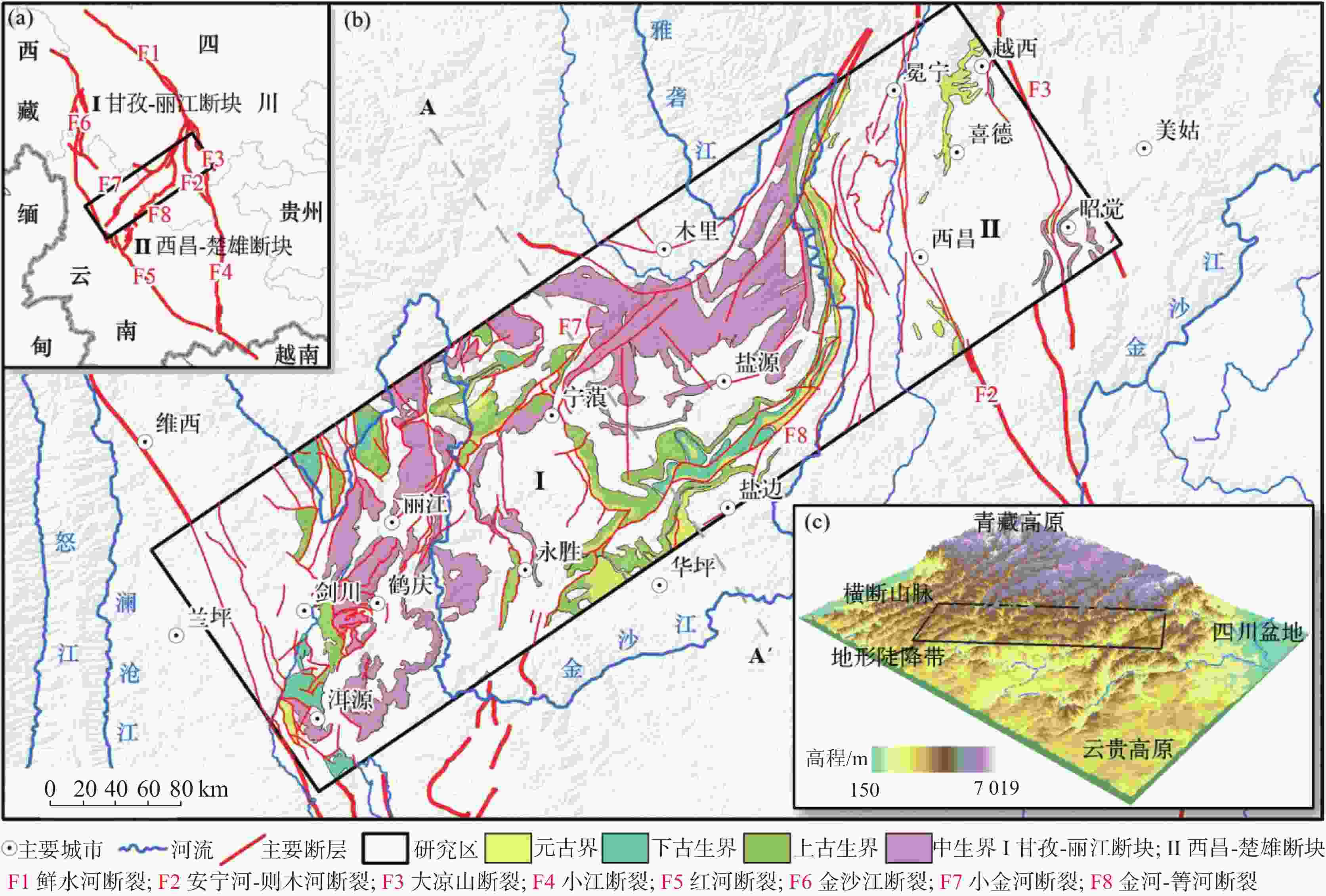
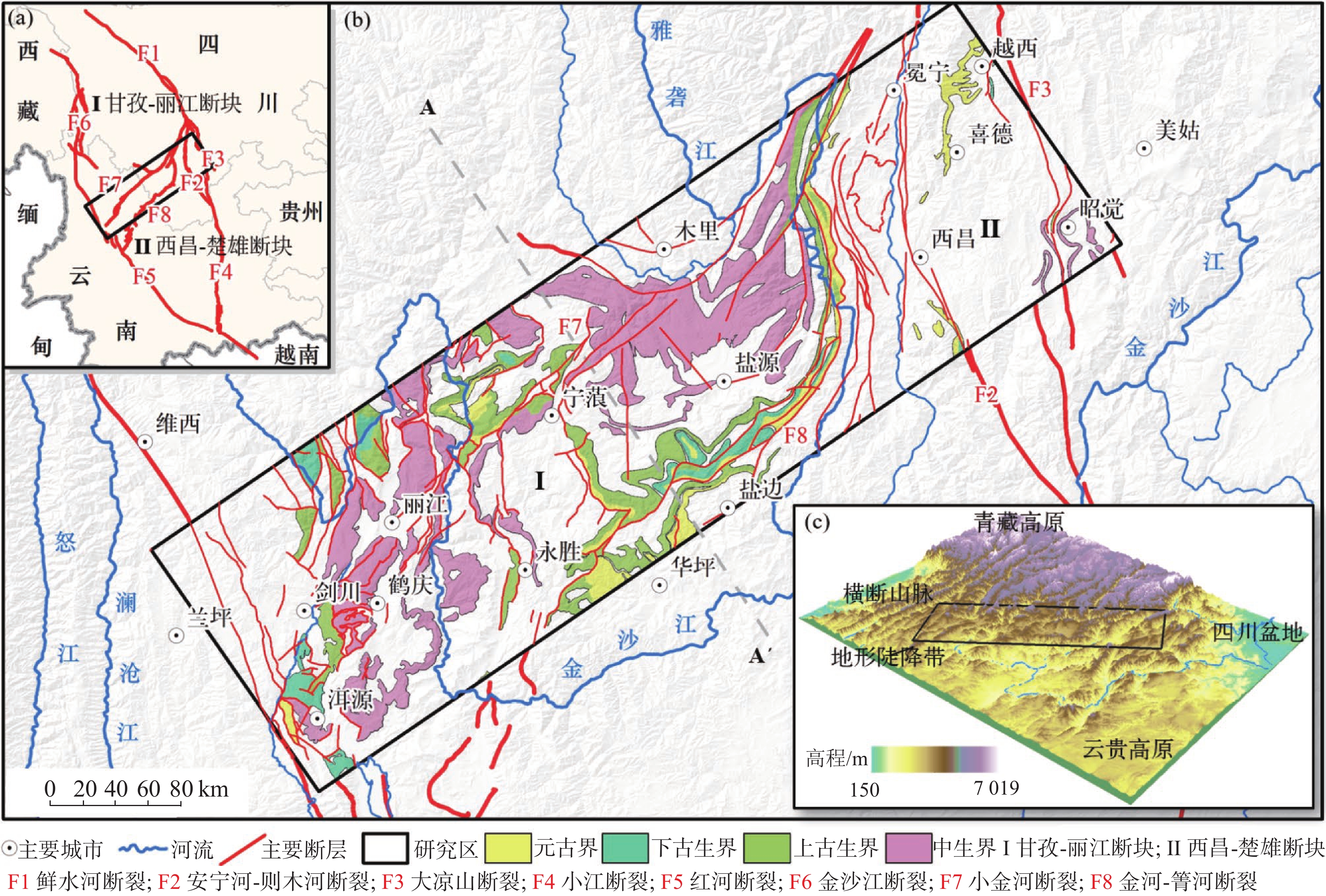
图 1 研究区地质背景图(a)菱形地块构造纲要图;(b)研究区地质条件与可溶岩分布图;(c)区域地势图
Figure 1. Geological background of the study area. (a) Rhombic block tectonic outline map ; (b) Geological conditions and soluble rock distribution map of the study area; (c) Regional topographic map
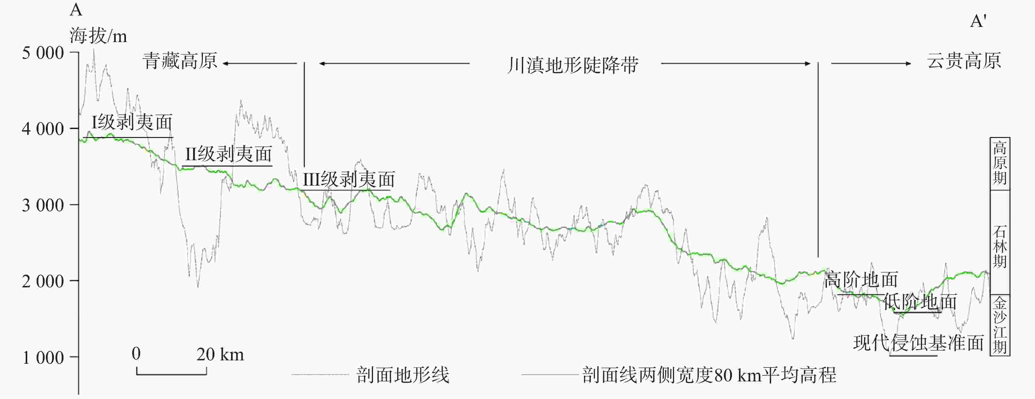
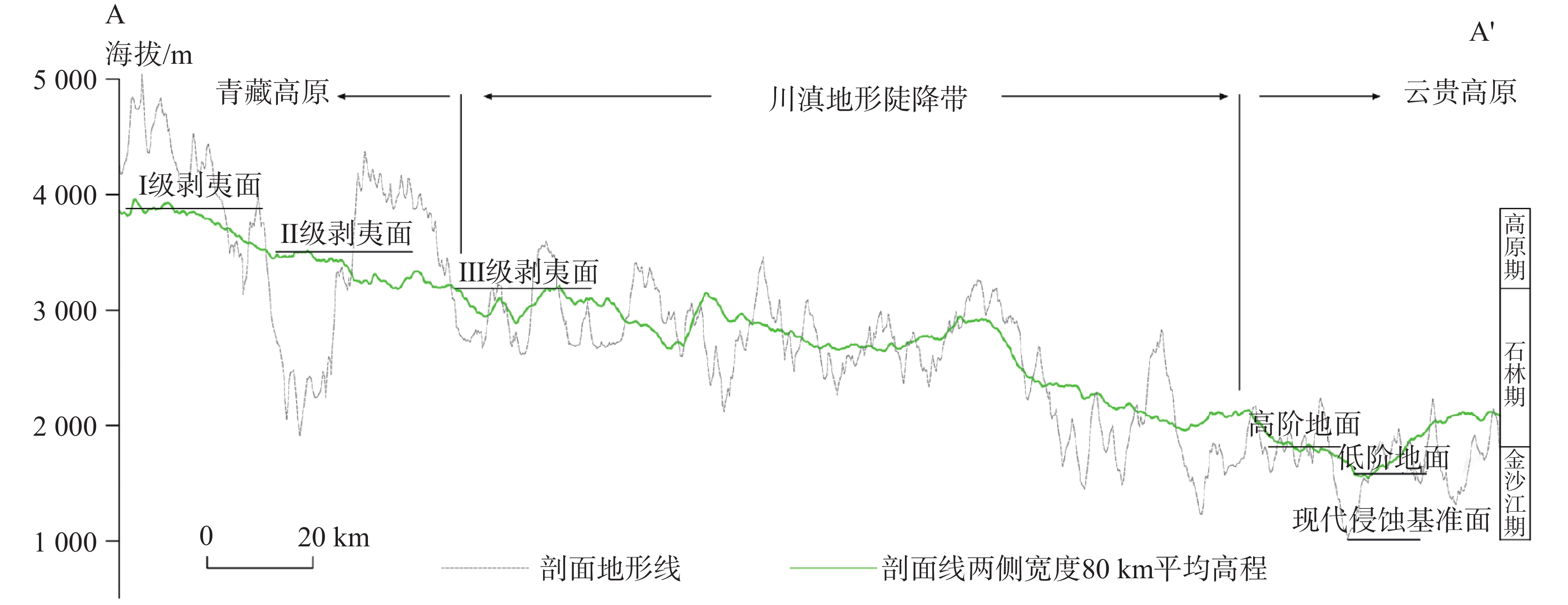
图 2 地形剖面与多级剥夷面分布示意图
Figure 2. Topographic profile and distribution of multi-level planation surfaces
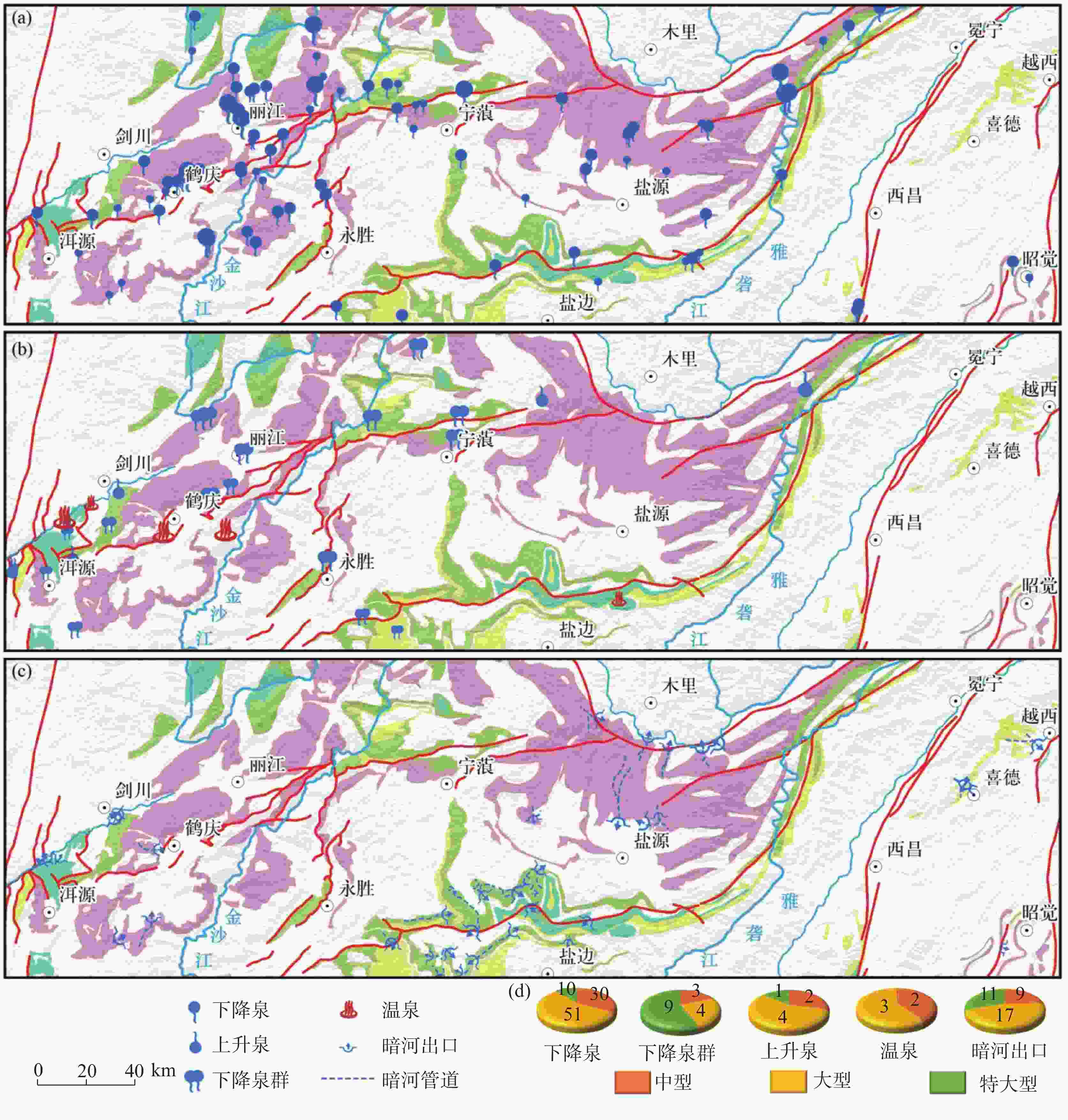
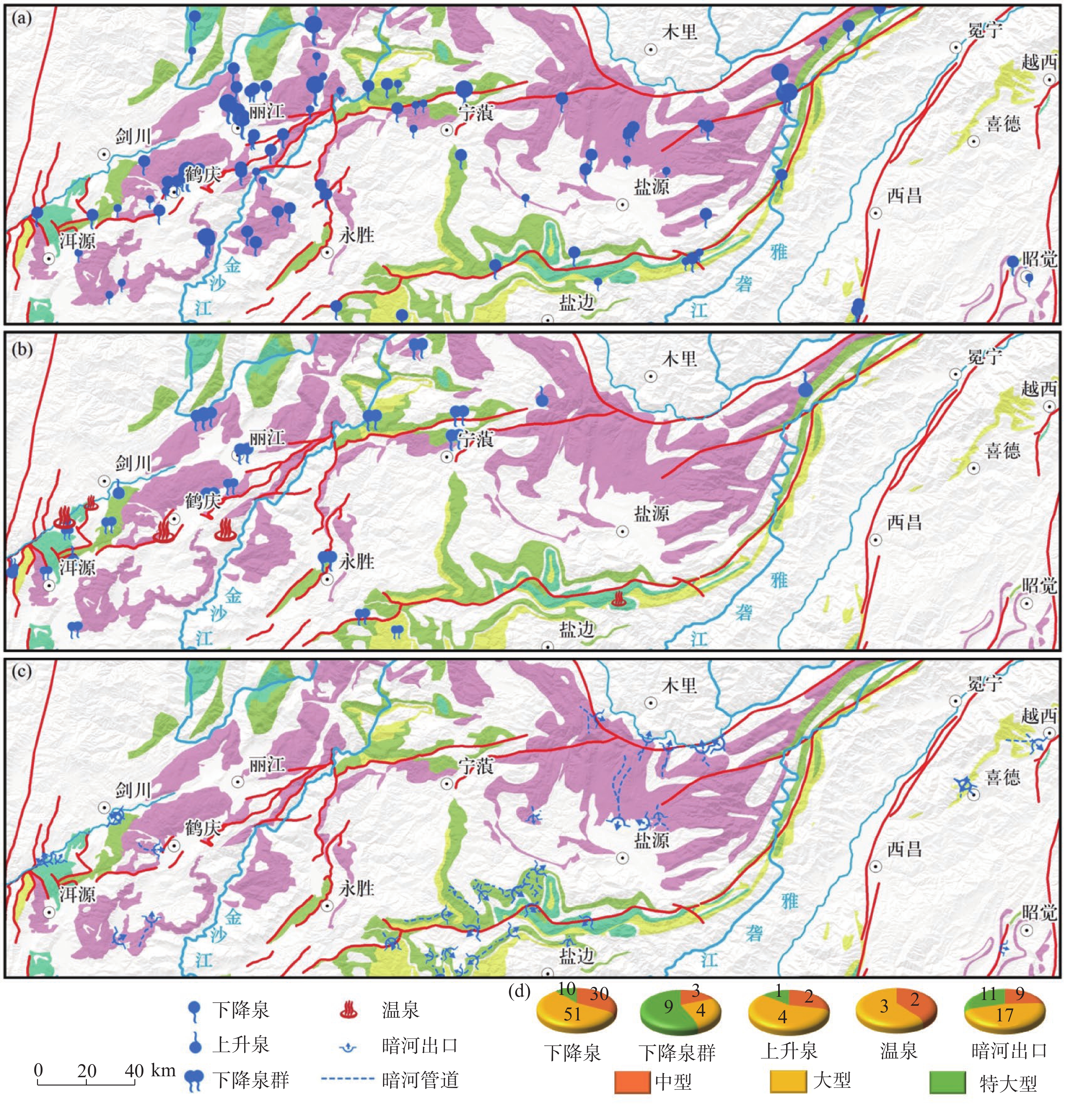
图 3 研究区岩溶水泉点分布图(a)下降泉(b)下降泉群、上升泉、温泉(c)暗河(d)各泉点流量规模占比
Figure 3. Distribution of concentrated karst water discharge points in the study area: (a) Descending springs; (b) Descending spring groups, ascending springs and hot springs; (c) Subterranean river; (d) Proportion of discharge magnitude for each type of discharge point
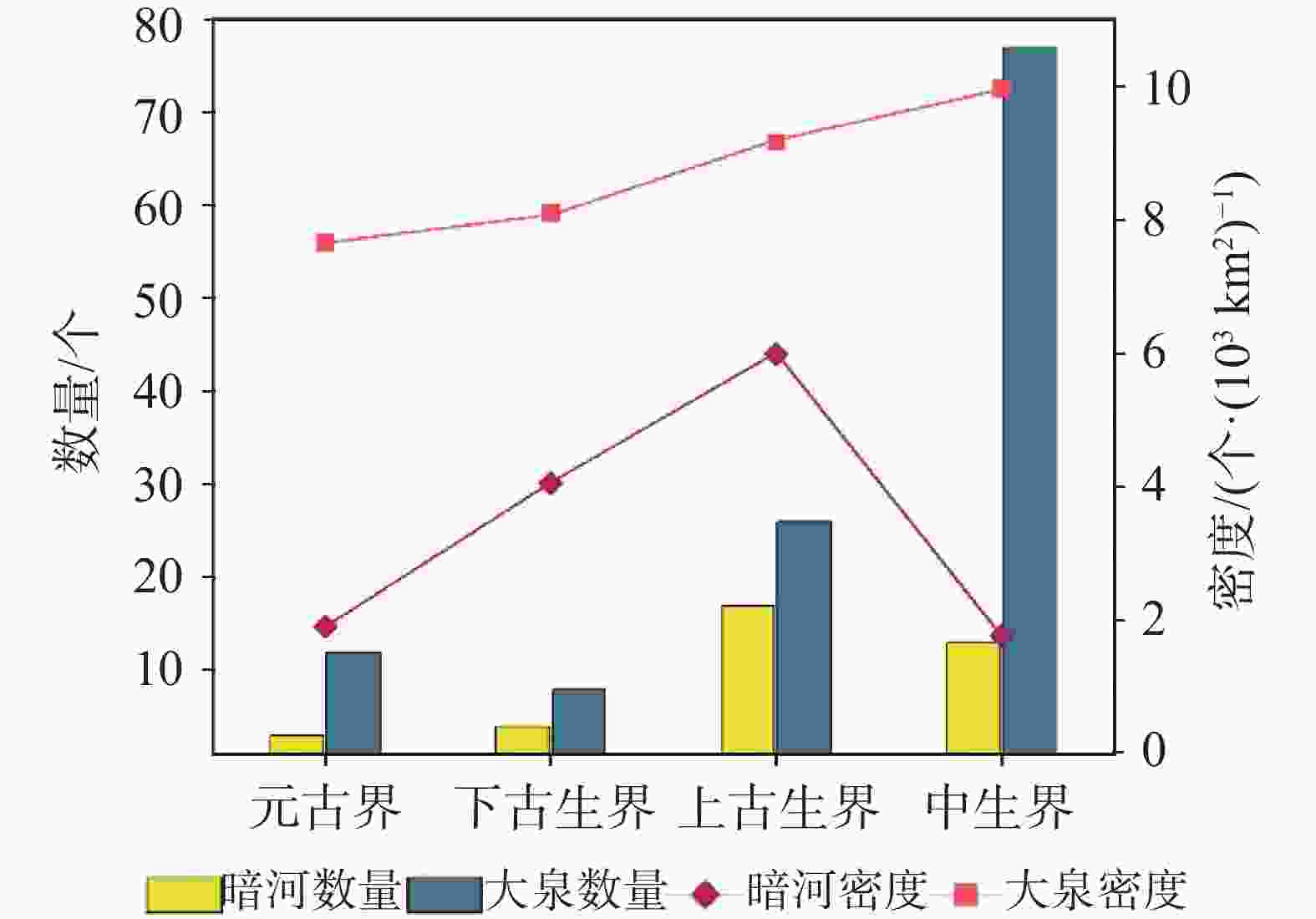
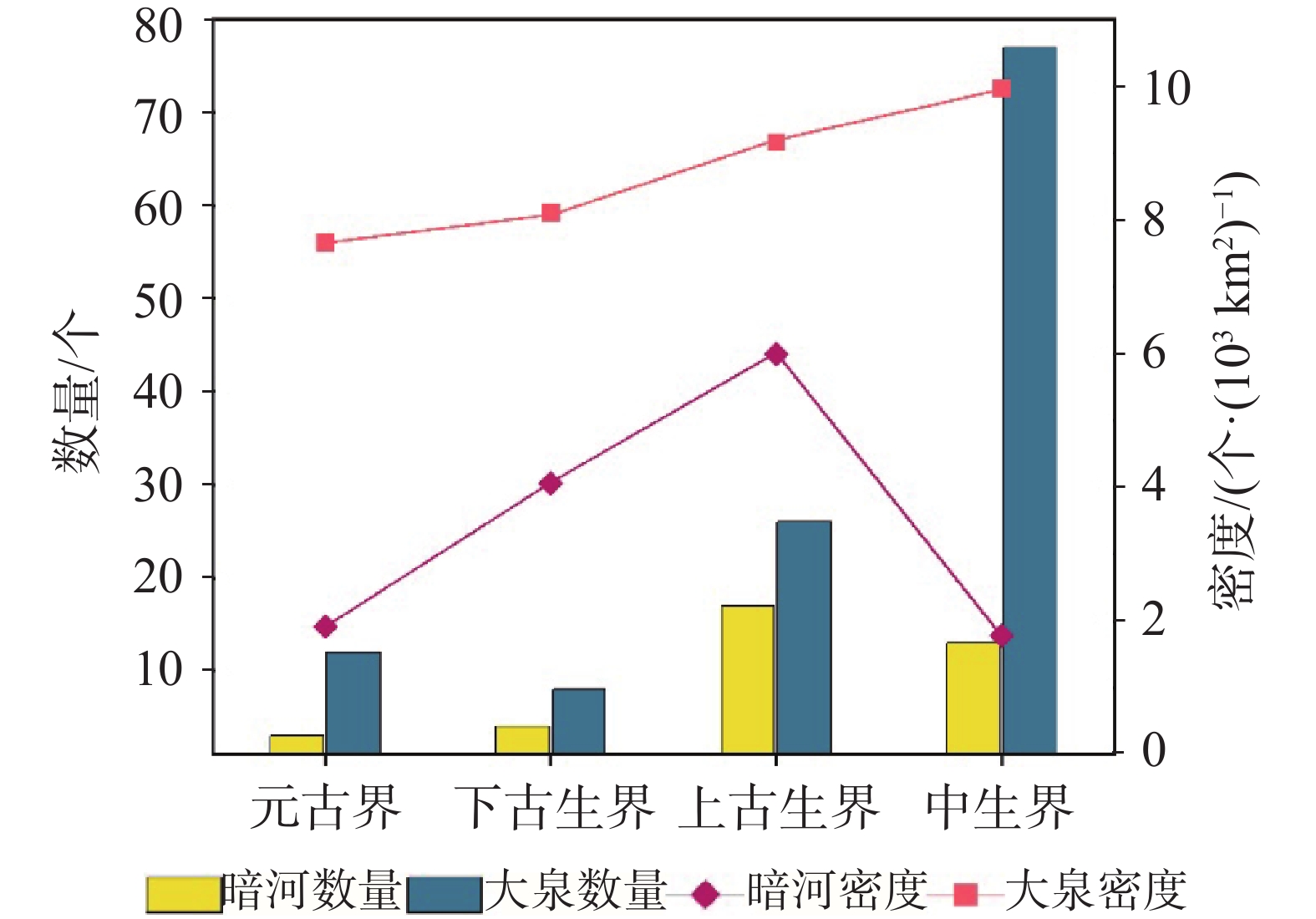
图 4 不同可溶岩层位中暗河与大泉的数量和密度的变化图
Figure 4. Variations in the quantity and density of subterranean rivers and large springs within different soluble rock strata
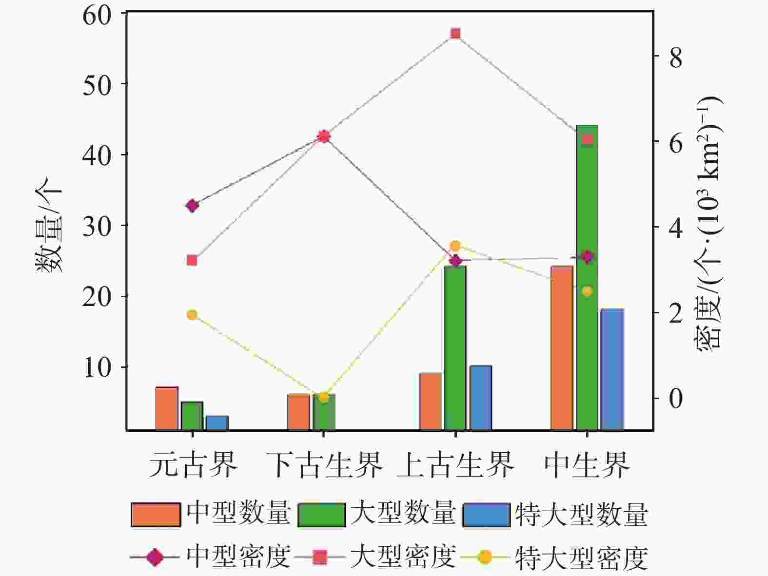
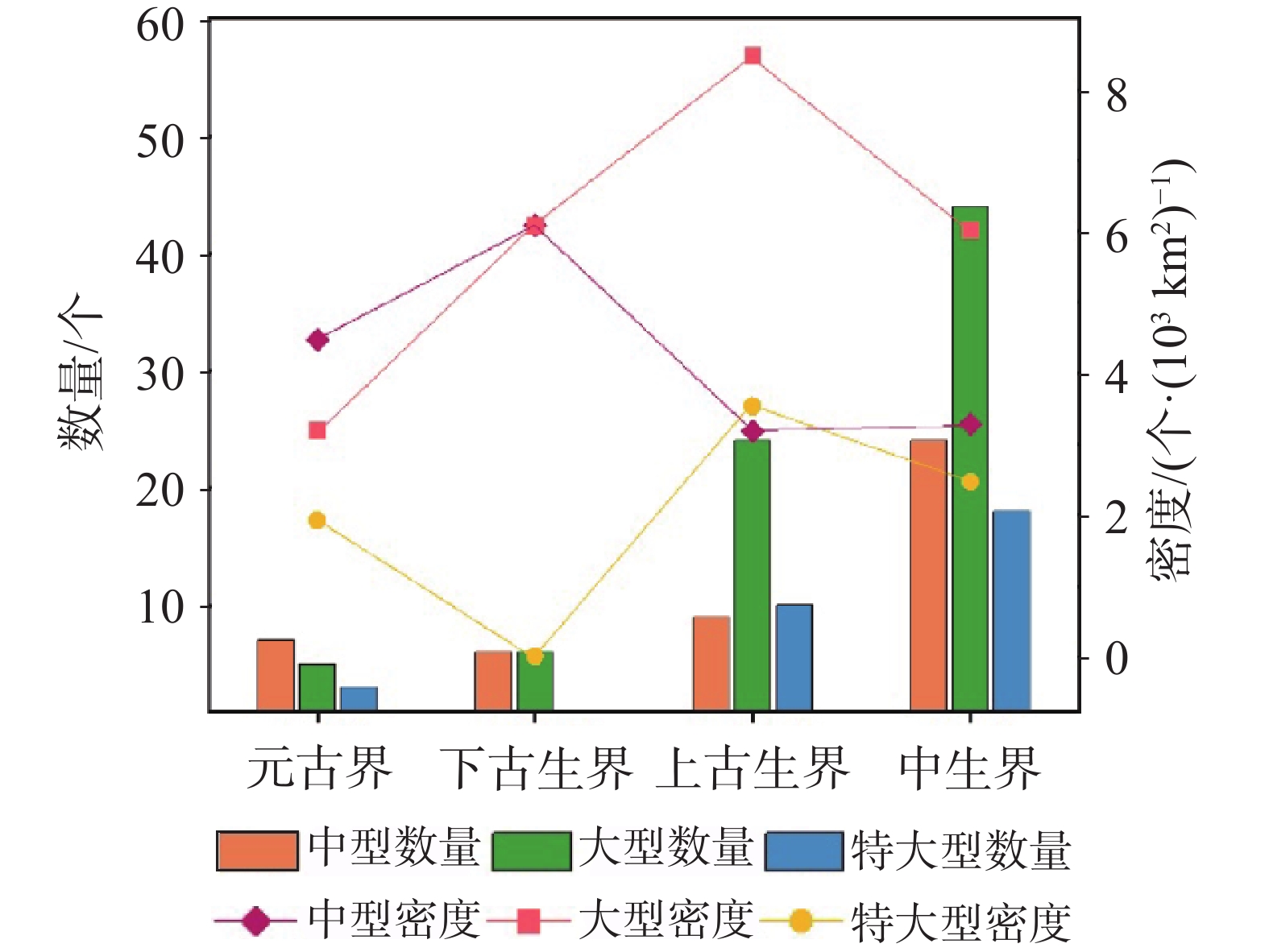
图 5 不同可溶岩层位中泉点流量规模级别的数量与密度变化图
Figure 5. Variations in the quantity and density of discharge points with different discharge magnitude grades in various soluble rock strata
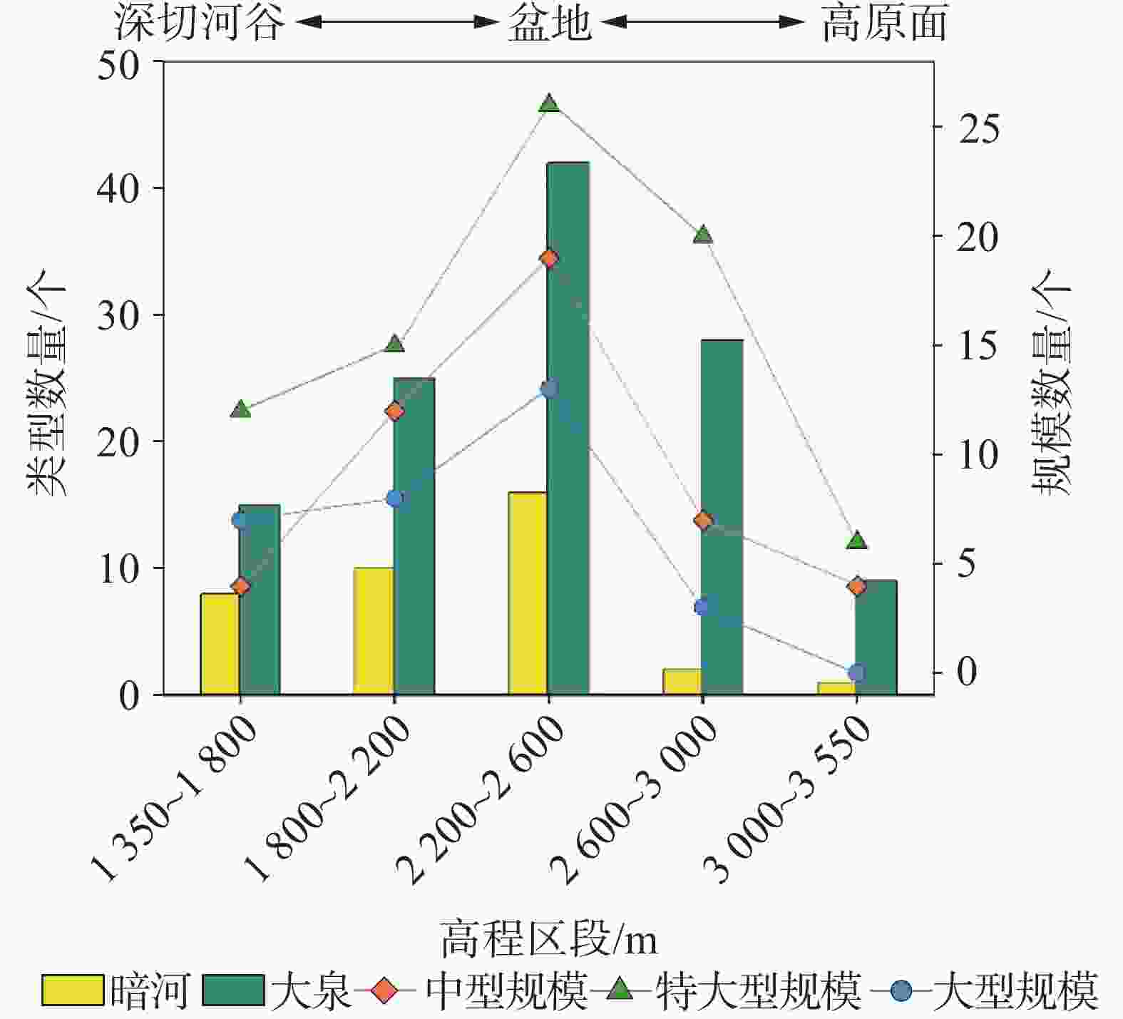
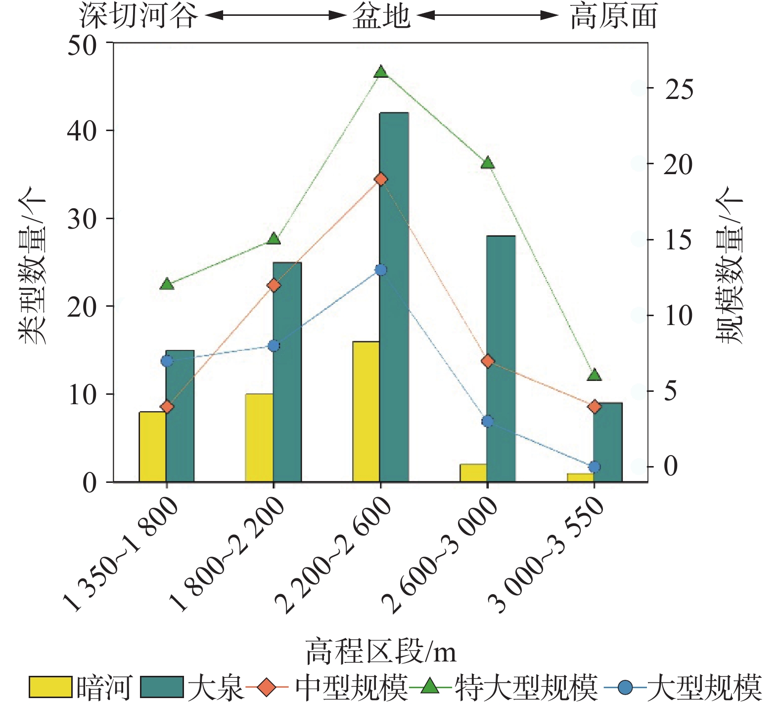
图 6 不同高程区段暗河与大泉及流量规模级别的数量分布图
Figure 6. Distribution of subterranean rivers, large springs and discharge points of different discharge magnitude grades in elevation intervals
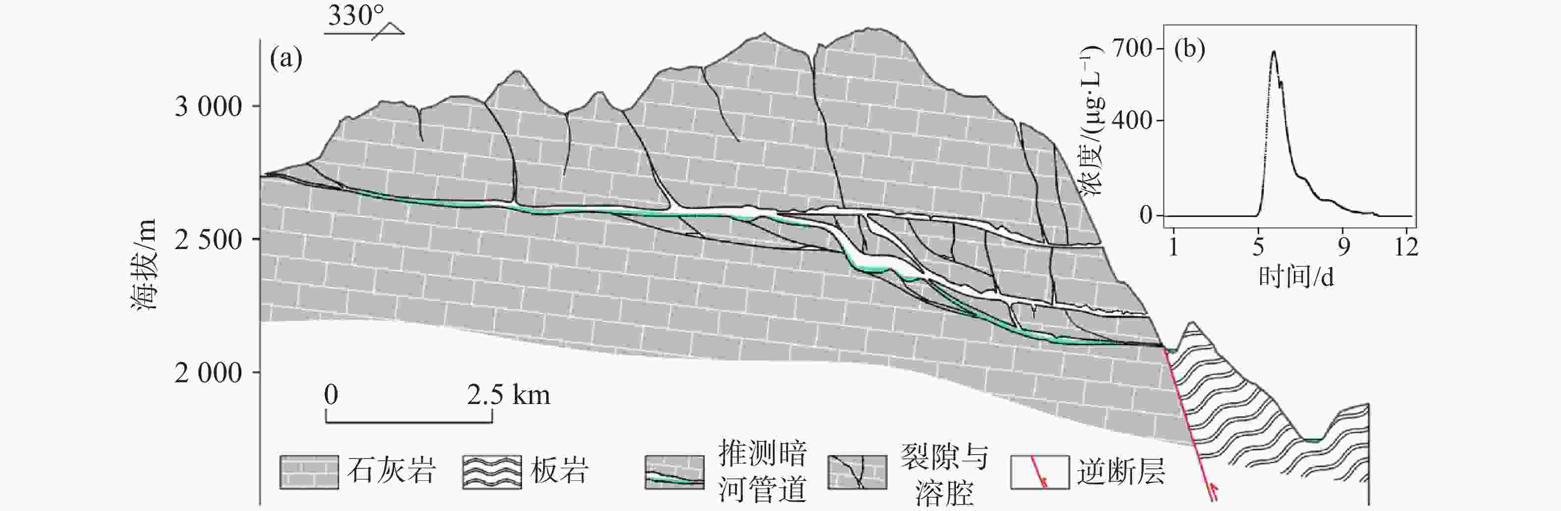
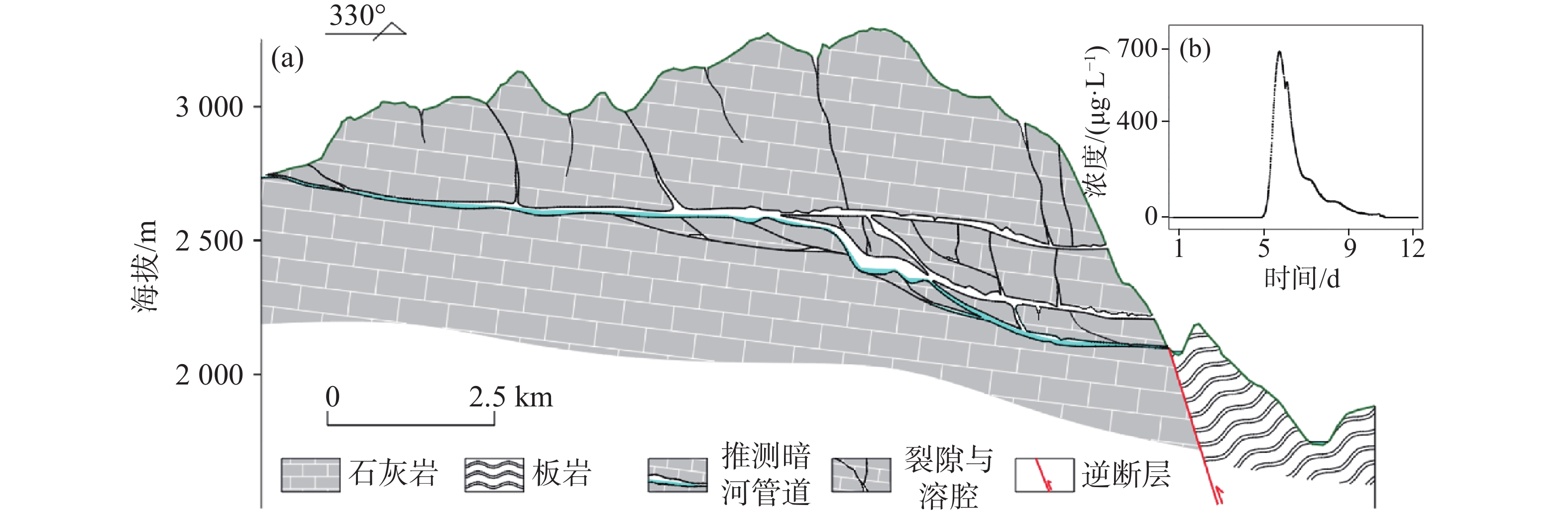
图 7 (a)构造抬升与河流下切控制下的羊窝子暗河多期管道结构示意图(b)管道示踪试验浓度-时间监测曲线
Figure 7. (a) Schematic diagram of multi-stage conduit structure of Yangwozi subterranean river controlled by tectonic uplift and river incision; (b) Concentration-time monitoring curve of conduit tracer test
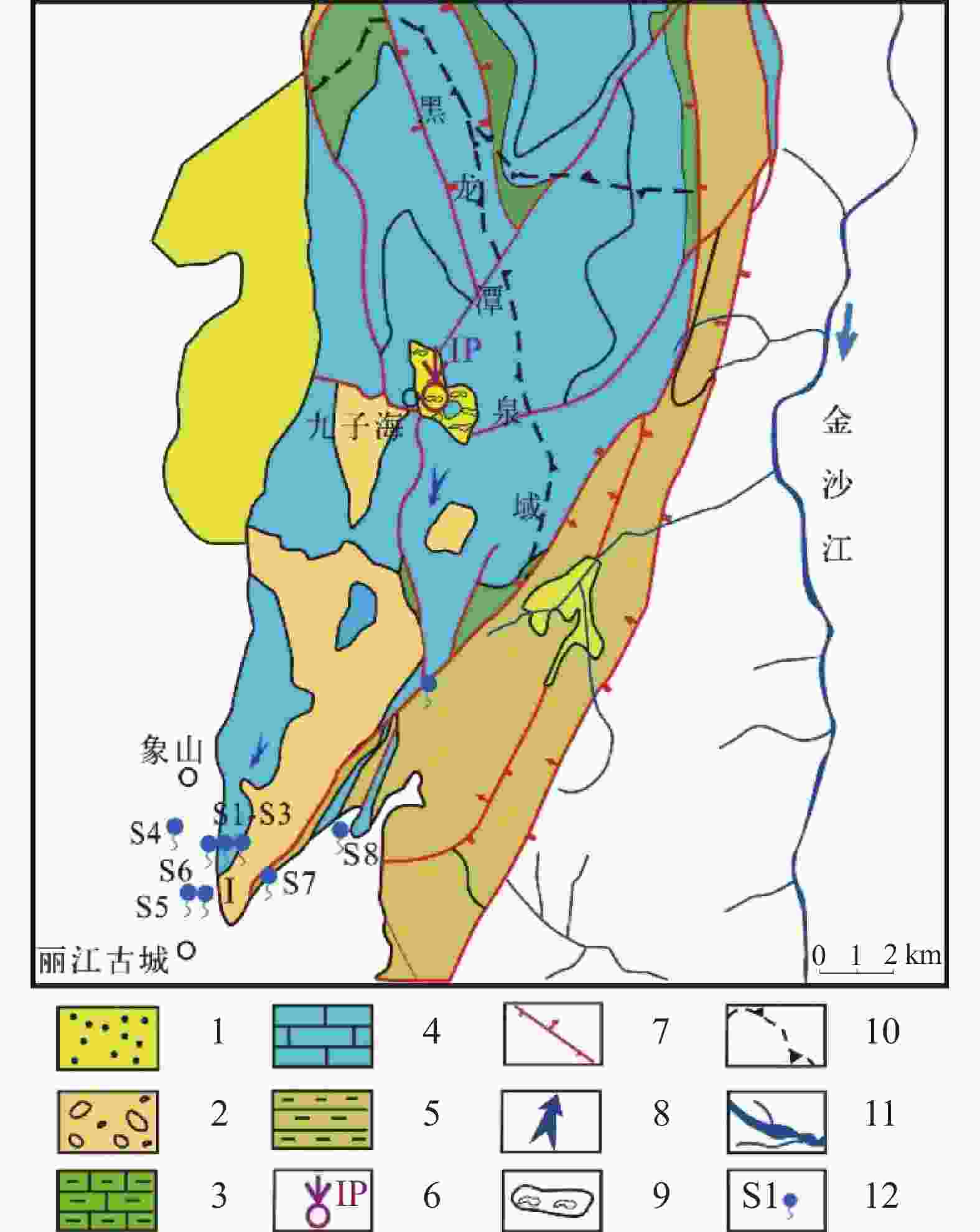
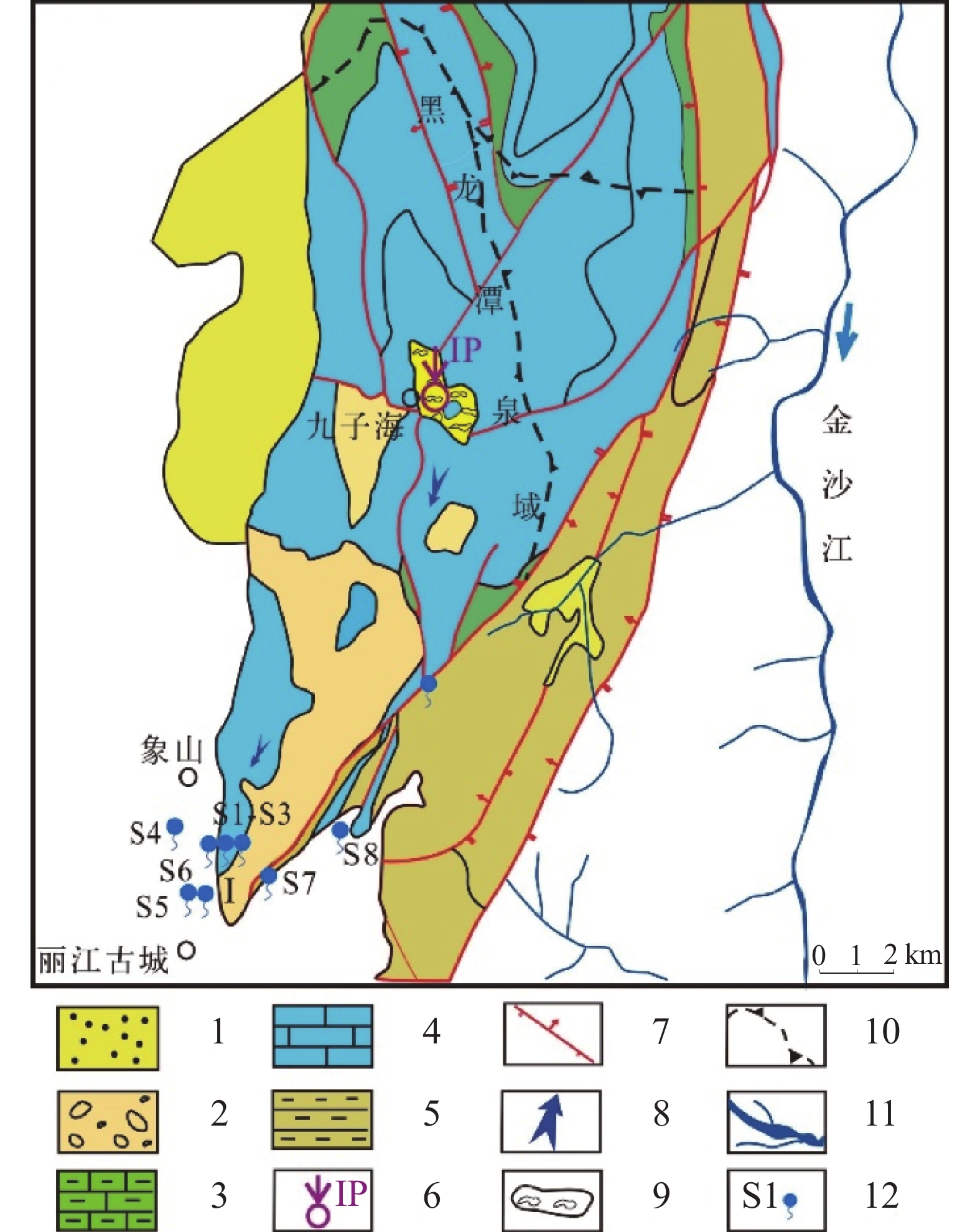
图 8 丽江古城黑龙潭泉域水文地质简图
1.第四系孔隙含水层;2.下第三系孔隙含水层;3.中三叠统下段岩溶含水层;4.中三叠统中上段岩溶含水层;5.上二叠统隔水层;6.示踪剂注入点;7.逆断层;8.地下水流向;9.岩溶洼地;10.地表分水岭;11.河流溪沟;12.泉点与编号
Figure 8. Hydrogeological sketch of Heilongtan Spring catchment, Lijiang Ancient City
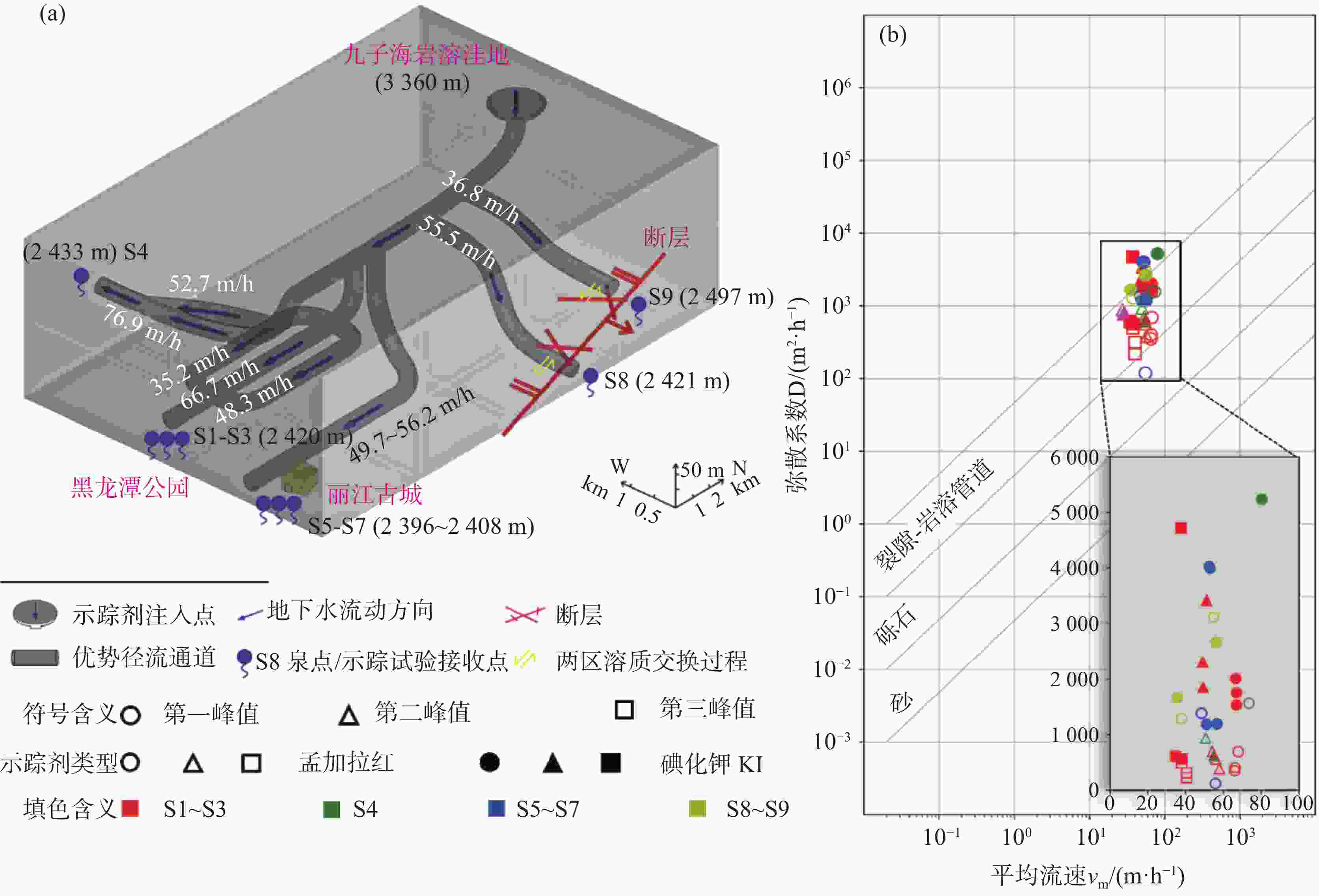
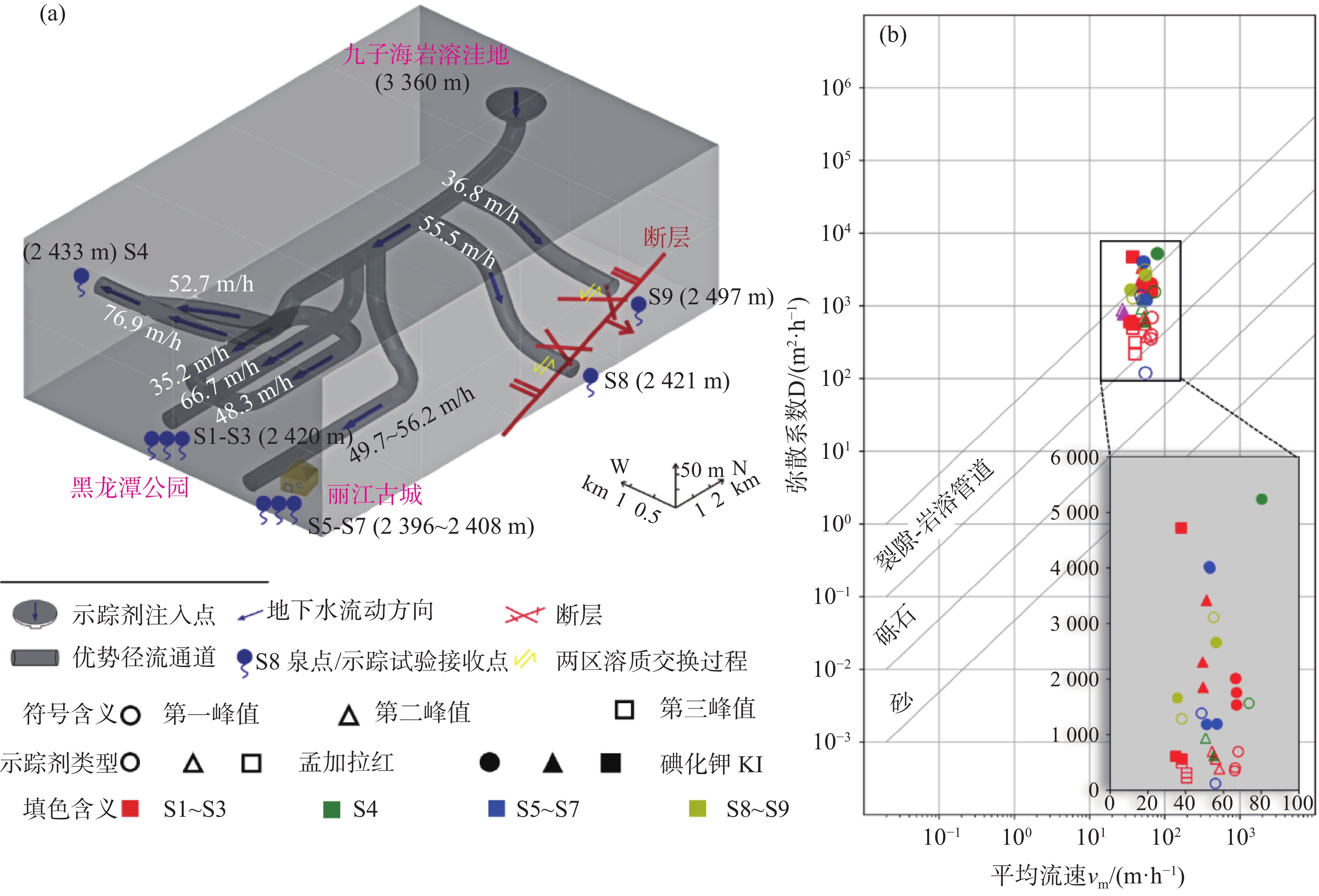
图 9 (a)黑龙潭泉域岩溶水系统主要结构特征概念模型(b)基于弥散系数和平均流速的含水介质类型图解法
Figure 9. (a) Conceptual model of primary structural features for karst water system, Heilongtan Spring catchment (b) Classification diagram of aquifer media using dispersion coefficient and average velocity
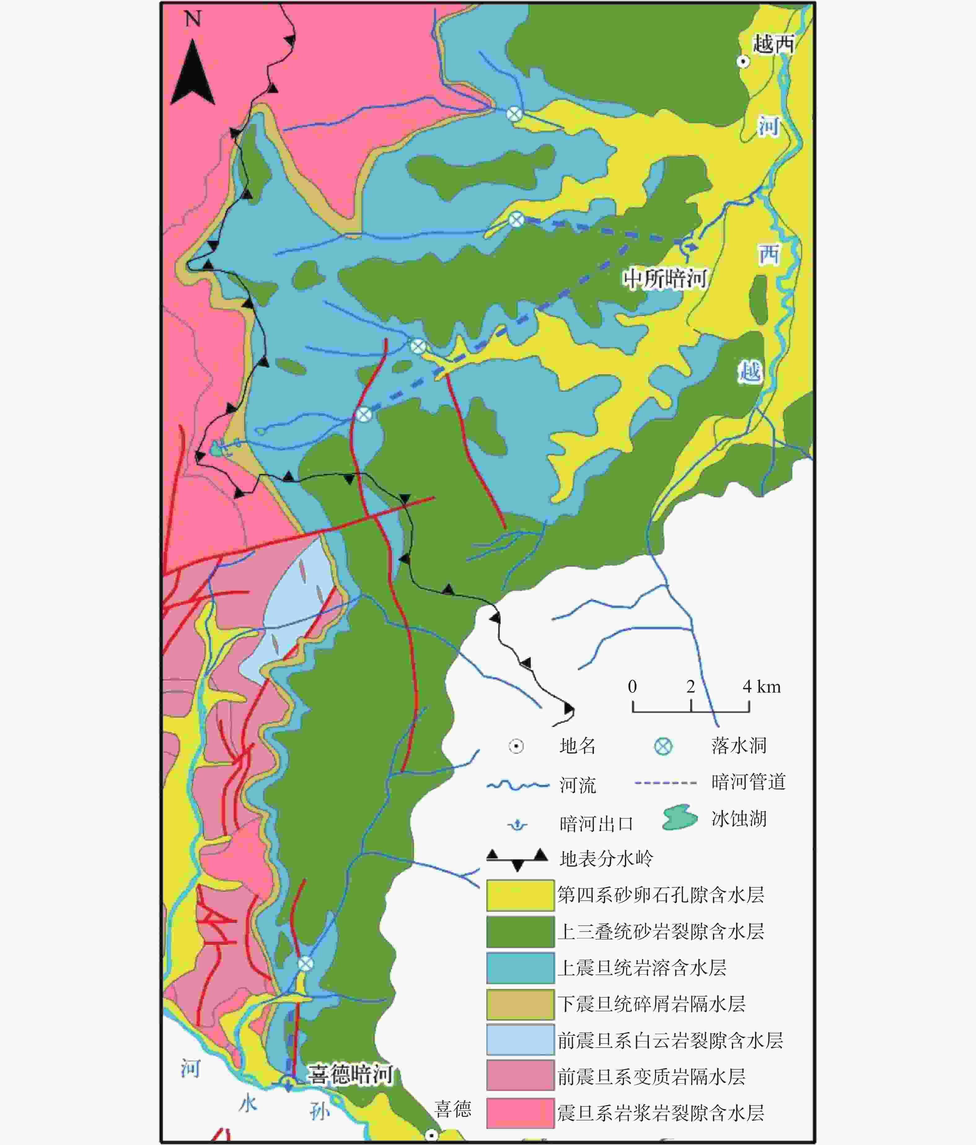
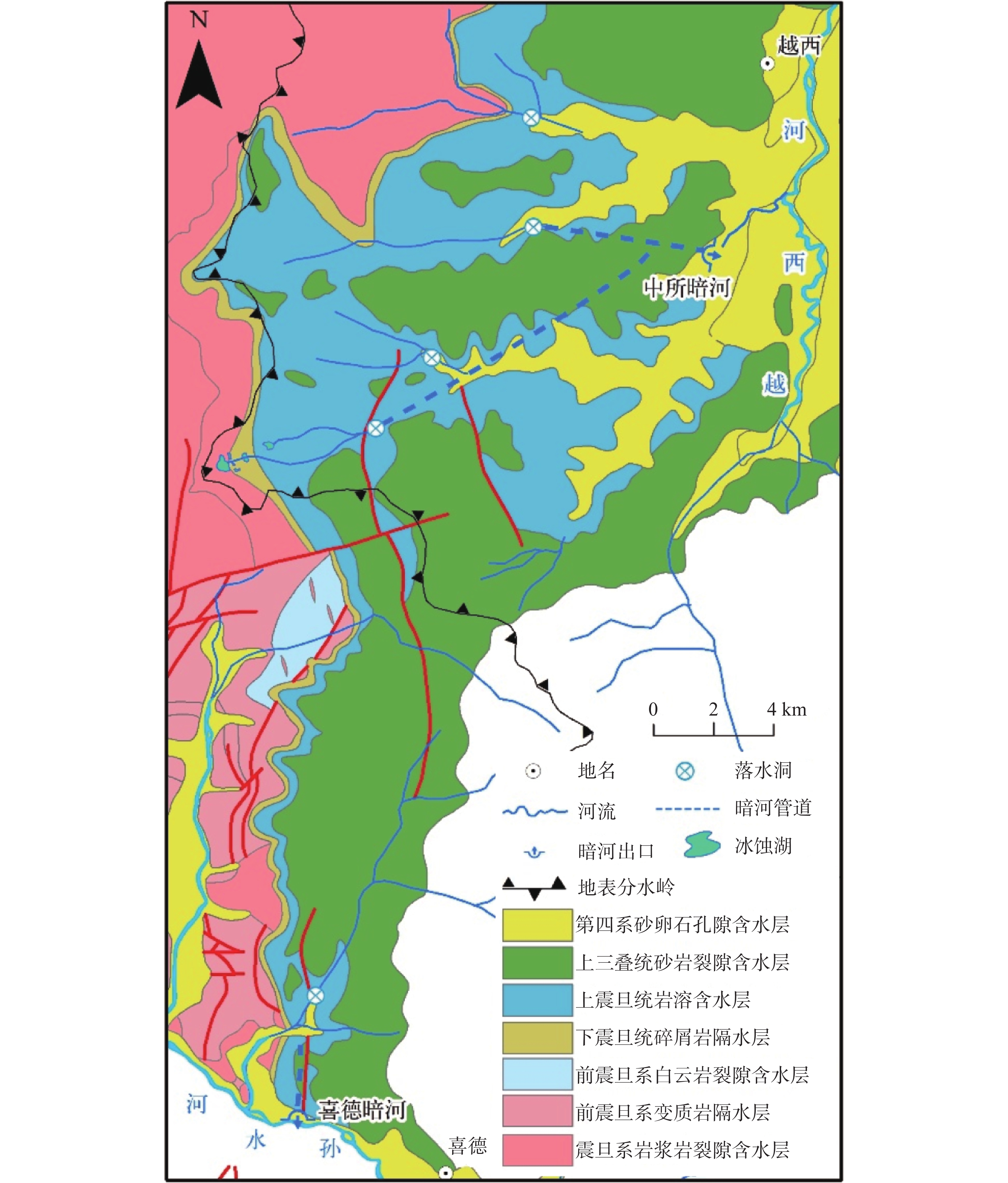
图 10 中所暗河与喜德暗河集水区水文地质简图
Figure 10. Hydrogeological sketch map of the catchment areas of Zhongsu subterranean river and Xide subterranean river
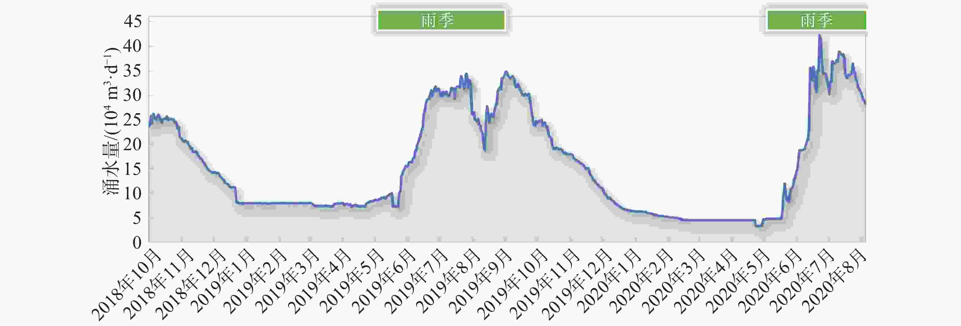
图 11 某线性工程穿越喜德暗河系统涌水量监测
Figure 11. Water inflow monitoring for a linear engineering project crossing the Xide subterranean river system
表 1 研究区可溶岩地层岩性特征简表
Table 1. Summary of lithological features of soluble-rock strata in the study area
地质单元 主要出露地层 岩性特征 出露面积/km2 分布区域 元古界 上震旦统 白云岩,夹硅质条带,底部含砂砾岩 1635 金河–箐河断裂两侧、越西—喜德一带 下古生界 中上奥陶统、寒武系 白云岩、灰质白云岩、灰岩,夹砂泥岩 986 盐源盆地南缘、剑川—洱源一带 上古生界 石炭系、下二叠统、泥盆系 灰岩、白云质灰岩 2765 金河–箐河断裂两侧、宁蒗西北 中生界 中三叠统 灰岩、白云质灰岩 7319 滇西北、盐源盆地周缘  下载: 导出CSV
表 2 各类泉点基础指标统计
Table 2. Statistics of basic parameters of different spring types
指标 泉点类型 下降泉 下降泉群 上升泉 温泉 暗河 特大型数量 (个) 10 9 1 0 11 大型数量 (个) 51 4 4 3 17 中型数量 (个) 30 3 2 2 9 流量四分位区间 (L/s) 85~294 115~932 92~203 72~154 119~693 出露高程区间 (m) 1356 ~3532 1486 ~2931 2098 ~2957 1776 ~2226 1350 ~3108 出露类型 接触泉/溢出泉为主 断层泉为主 管道溢流
下载: 导出CSV
-
[1] Xuan S B, Shen C Y, Shen W B, Wang J P, Li J G. Crustal structure of the southeastern Tibetan Plateau from gravity data: new evidence for clockwise movement of the Chuan−Dian rhombic block[J]. Journal of Asian Earth Sciences, 2018, 159: 98-108. doi: 10.1016/j.jseaes.2018.03.018 [2] 程佳, 刘杰, 甘卫军, 余怀忠, 李纲. 川滇菱形块体东边界各断层段强震演化特征研究[J]. 中国科学: 地球科学, 2011, 41(9): 1311-1326.Cheng Jia, Liu Jie, Gan Weijun, Yu Huaizhong, Li Gang. Characteristics of strong earthquake evolution around the eastern boundary faults of the Sichuan-Yunnan rhombic block. Sci China Earth Sci, 2011, 41(9): 1311-1326. [3] 李国和, 王思敬, 尚彦军, 张强. 川滇交界地区地壳结构及现代地壳活动模式[J]. 地质力学学报, 2000, 6(2): 82-91. doi: 10.3969/j.issn.1006-6616.2000.02.013li Guohe, Wang Sijing, Shang Yanjun, Zhang Qiang. The crustal structure and mode of crustal movement in the Sichuan-Yunnan Region[J]. Journal of Geomechanics, 2000, 6(2): 82-91. doi: 10.3969/j.issn.1006-6616.2000.02.013 [4] 黄润秋, 王士天, 张倬元, 刘汉超. 中国西南地壳浅表层动力学过程及其工程环境效应研究[M]. 成都: 四川大学出版社, 2001.Huang Runqiu, Wang Shitian, Zhang Zhuoyuan, Liu Hanchao. Dynamic processes of shallow crust in southwest China and their engineering environmental effects[M]. Chengdu: Sichuan University Press, 2001. [5] 王铠元. 金沙江川滇交界段构造—地貌特征[J]. 云南地质, 1989(1): 1-10.Wang Kaiyuan. Structural-geomorphic features of the jinsha river sector in the Sichuan-Yunnan boundary region[J]. Yunnan Geology, 1989(1): 1-10. [6] 王宇. 断陷盆地岩溶水赋存规律[M]. 昆明: 云南科技出版社, 2003.WANG Yu. Storage rule of karst water in fault basins[M]. Kunming: Yunnan Science and Technology Press, 2003. [7] 韩啸, 陈鑫, 郑克勋, 刘胜. 示踪试验在岩溶大泉修复中的应用: 以丽江黑龙潭为例[J]. 中国岩溶, 2019, 38(4): 524-531. doi: 10.11932/karst20190408Han Xiao, Chen Xin, Zheng Kexun, Liu Sheng. Application of the tracer test in karst hydrogeological prospecting: An example of Heilongtan, Lijiang, Yunnan[J]. Carsologica Sinica, 2019, 38(4): 524-531. doi: 10.11932/karst20190408 [8] 覃绍媛, 李泽琴, 许模. 黑龙潭泉域地下水化学特征及补给源识别[J]. 人民黄河, 2020, 42(3): 63-67 doi: 10.3969/j.issn.1000-1379.2020.03.012Qin Shaoyuan, Li Zeqin, Xu Mo. Groundwater chemical characteristics and recharge source identification of Heilongtan spring area[J]. Yellow River, 2020, 42(3): 63-67. doi: 10.3969/j.issn.1000-1379.2020.03.012 [9] 康晓波, 王宇, 张华, 曹瑾. 丽江黑龙潭泉群水文地质特征及断流的影响因素分析[J]. 中国岩溶, 2013, 32(4): 398-403.Kang Xiaobo, Wang Yu, Zhang Hua, Cao Jin. Hydrogeologic features and influence factors of zero flow of the Heilongtan spring group in Lijiang[J]. Carsologica Sinica, 2013, 32(4): 398-403. [10] 岑鑫雨, 钟金先, 邓国仕, 许模. 基于迟滞排泄水箱模型模拟岩溶断流泉水文过程[J]. 中国岩溶, 2023, 42(4): 711-721. doi: 10.11932/karst20230407Cen Xinyu, Zhong Jinxian, Deng Guoshi, Xu Mo. Modelling the hydrological process of the dried-up karst spring based on a reservoir model for hysteretic discharge[J]. Carsologica Sinica, 2023, 42(4): 711-721. doi: 10.11932/karst20230407 [11] 曾成, 杨睿, 杨明明, 胡君春, 武贵华, 樊宇. 丽江市黑龙潭泉群断流的人工神经网络模拟[J]. 中国岩溶, 2013, 32(4): 391-397.Zeng Cheng, Yang Rui, Yang Mingming, Hu Junchun, Wu Guihua, Fan Yuhong. Artificial neural network simulation to zero flow of the Heilongtan spring groups in Lijiang[J]. Carsologica Sinica, 2013, 32(4): 391-397. [12] 李豫馨, 许模, 高伟, 漆继红. 基于时间序列方法预测丽江黑龙潭泉域流量[J]. 人民珠江, 2016, 37(3): 6-9. doi: 10.3969/j.issn.1001-9235.2016.03.002Li Yuxin, Xu Mo, Gao Wei, Qi Jihong. Application of time series analysis to prediction of flow in Heilongtan spring group in Lijiang[J]. Pearl River, 2016, 37(3): 6-9. doi: 10.3969/j.issn.1001-9235.2016.03.002 [13] 马祖陆, 周春宏, 张之淦, 黄俊杰. 四川锦屏落水洞岩溶地下水示踪[J]. 中国岩溶, 2006, 25(3): 201-210. doi: 10.3969/j.issn.1001-4810.2006.03.004Ma Zulu, Zhou Chunhong, Zhang Zhigan, Huang Junjie. Tracer test to karst groundwater in luoshuidong area, Jinping, Sichuan[J]. Carsologica Sinica, 2006, 25(3): 201-210. doi: 10.3969/j.issn.1001-4810.2006.03.004 [14] 李颂章, 荣冠, 罗琳, 侯迪. 锦屏大河湾磨房沟泉流量衰减规律研究[J]. 工程勘察, 2013, 41(12): 32-36+89LI Songzhang, Rong Guan, Luo Lin, Hou Di. Dynamic study on discharge attenuation in Mofanggou spring at Jinping river bend[J]. Geotechnical Investigation & Surveying, 2013, 41(12): 32-36+89. [15] 单治钢, 周春宏, 荣冠作. 雅砻江大河湾岩溶水文地质及工程效应研究[M]. 北京: 科学出版社, 2018: 93-369.Shan Zhigang, Zhou Chunhong, Rong Guanzuo. Research on karst hydrogeology and engineering effects of the big bend reach of Yalong River[M]. Science Press, 2018: 93-369. [16] 郭纯青. 中国岩溶地下河系及其水资源[M]. 桂林: 广西师范大学出版社, 2004: 1-108.Guo Chunqing. Karst underground river systems and water resources in China[M]. Guilin: Guangxi Normal University Press, 2004: 1-108. [17] 韩行瑞, 鲁荣安, 李庆松, 唐建生, 梁永平. 岩溶水系统: 山西岩溶大泉研究[M]. 北京: 地质出版社, 1993.Han Xingrui, Lu Rongan, Li Qingsong, Tang Jiansheng, Liang Yongping. Karst water systems: A Study on big karst springs in Shanxi[M]. Beijing: Geological Publishing House, 1993. [18] Sun W J, Song J X, Yang W K, Zheng Y J, Li C Y, Kuang D. Distribution of Carbonate Rocks and Variation Analysis of Karst Water Resources in China[J]. Carbonates Evaporites, 2020, 35: 121. doi: 10.1007/s13146-020-00657-7 [19] 王富葆. 青藏高原上的喀斯特(摘要)[J]. 中国岩溶, 1990(3): 83-84.Wang Fubao. Karst on the Qinghai-Xizang Plateau (Abstract)[J]. Carsologica Sinica, 1990(3): 83-84. [20] 中国科学院地质研究所岩溶研究组. 中国岩溶研究[M]. 北京: 科学出版社, 1979: 268-275.Karst Research Group, Institute of Geology, Chinese Academy of Sciences. Research on karst in China[M]. Beijing: Science Press, 1979: 268-275. [21] 裴建国, 梁茂珍, 陈阵. 西南岩溶石山地区岩溶地下水系统划分及其主要特征值统计[J]. 中国岩溶, 2008, 27(1): 6-10. doi: 10.3969/j.issn.1001-4810.2008.01.002Pei Jianguo, Liang Maozhen, Chen Zhen. Classification of karst groundwater system and statistics of the main characteristic values in Southwest China karst mountain[J]. Carsologica Sinica, 2008, 27(1): 6-10. doi: 10.3969/j.issn.1001-4810.2008.01.002 [22] 马剑飞. 金沙江结合带岩溶发育特征与工程灾害效应[D]. 北京: 中国地质科学院, 2023: 88-139.Ma Jianfei. Karst development characteristics and engineering disaster effects in Jinsha River Combined Zone[D]. Beijing: Chinese Academy of Geological Sciences, 2023, 88-139. [23] 王宇, 张贵, 张华, 等. 云南省岩溶水文地质环境地质调查与研究[M]. 北京: 地质出版社, 2018: 31.Wang Yu, Zhang Gui, Zhang Hua, et al. Investigation and research on karst hydrogeology and environmental geology in Yunnan Province[M]. Beijing: Geological Publishing House, 2018: 31. [24] 梅正星. 用示踪曲线分析岩溶通道的展布[J]. 工程勘察, 1988(1): 36-38.Mei Zhengxing. Analysis of the distribution of karst conduits based on tracer curves[J]. Geotechnical Investigation & Surveying, 1988(1): 36-38. [25] 任世川, 杨晓艳, 杨颖彬, 刘海峰, 杨帆. 丽江黑龙潭地下河系统的水均衡分析与预测评价[J]. 中国岩溶, 2023, 42(6): 1183-1192. doi: 10.11932/karst20230604Ren Shichuan, Yang Xiaoyan, Yang Yingbin, Liu Haifeng, Yang Fan. Equilibrium analysis and prediction evaluation of the Heilongtan groundwater system in Lijiang of northwestern Yunnan Province[J]. Carsologica Sinica, 2023, 42(6): 1183-1192. doi: 10.11932/karst20230604 [26] 岑鑫雨. 丽江黑龙潭岩溶水系统特征及泉群断流机制研究[D]. 成都: 成都理工大学, 2022: 1-112.Cen Xinyu. Research on characteristics of the karst groundwater system in the Heilongtan Springs of Lijiang and dry-up mechanism of springs [D]. Chengdu: Chengdu University of Technology, 2022: 1-112. [27] 李腾芳, 黄奇波, 沈利娜, 吴庆鹏, 马俊飞, 廖红为, 吴华英, 邹昌霈, 普政功, 冷茹冰. 基于示踪试验和裂隙测量分析地下河管道特征及控制因素: 以罗汉肚地下河为例[J]. 中国岩溶, 2025, 44(5): 981-991. doi: 10.11932/karst20250505Li Tengfang, Huang Qibo, Shen Lina, Wu Qingpeng, Ma Junfei, Liao Hongwei, Wu Huaying, Zou Changpei, Pu Zhenggong, Leng Rubin. Analysis of characteristics and controlling factors of underground river pipeline based on tracer tests and fracture measurement: Take the Luohandu underground river as an example[J]. Carsologica Sinica, 2025, 44(5): 981-991. doi: 10.11932/karst20250505 [28] 杨平恒, 罗鉴银, 彭稳, 夏凯生, 林玉石. 在线技术在岩溶地下水示踪试验中的应用: 以青木关地下河系统岩口落水洞至姜家泉段为例[J]. 中国岩溶, 2008, 27(3): 215-220. doi: 10.3969/j.issn.1001-4810.2008.03.004Yang Pingheng, Luo Jianyin, Peng Wen, Xia Kaisheng, Lin Yushi. Application of online technique in tracer test: A case in Qingmuguan subterranean river system, Chongqing, China[J]. Carsologica Sinica, 2008, 27(3): 215-220. doi: 10.3969/j.issn.1001-4810.2008.03.004 [29] 耿新新, 张凤娥, 陈宗宇, 聂振龙, 朱谱成. 基于多源人工示踪试验表征岩溶管道结构特征: 以贵州苍蒲凹地下河为例[J]. 地质科技通报, 2022, 41(5): 324-332. doi: 10.19509/j.cnki.dzkq.2022.0185Geng Xinxin, Zhang Feng'e, Chen Zongyu, Nie Zhenlong, Zhu Pucheng. Characterization of karst conduit structure based on multisource artificial tracer test: A case study of the Cangpuwa underground river in Guizhou Province[J]. Bulletin of Geological Science and Technology, 2022, 41(5): 324-332. doi: 10.19509/j.cnki.dzkq.2022.0185 [30] 于正良, 杨平恒, 谷海华, 方明洋, 李建鸿, 陈金龙. 基于在线高分辨率示踪技术的岩溶泉污染来源及含水介质特征分析: 以重庆黔江区鱼泉坎为例[J]. 中国岩溶, 2014, 33(4): 498-503. doi: 10.11932/karst20140415Yu Zhengliang, Yang Pingheng, Gu Haihua, Fang Mingyang, Li Jianhong, Chen Jinlong. Analysis on pollution sources of karst spring and characteristics of aquifer media based on online high-resolution tracer technique: A case study of Yuquankan in Qianjiang District, Chongqing[J]. Carsologica Sinica, 2014, 33(4): 498-503. doi: 10.11932/karst20140415 [31] 张亮, 陈植华, 周宏, 罗朝晖. 典型岩溶泉水文地质条件的调查与分析: 以香溪河流域白龙泉为例[J]. 水文地质工程地质, 2015, 42(2): 31-37. doi: 10.16030/j.cnki.issn.1000-3665.2015.02.05Zhang Liang, Chen Zhihua, Zhou Hong, Luo Zhaohui. Investigation and analysis of the hydrogeological characteristics of the typical karst spring in the Xiangxi River Basin: exemplified by the Bailong Spring in Xingshan County of Hubei[J]. Hydrogeology & Engineering Geology, 2015, 42(2): 31-37. doi: 10.16030/j.cnki.issn.1000-3665.2015.02.05 [32] Schröter J. Mikro- und Makrodispersivität poröser Grundwasserleiter[J]. Meyniana, 1984, 36: 1-34. -

 点击查看大图
计量
- 文章访问数: 20
- HTML浏览量: 11
- PDF下载量: 0
- 被引次数: 0
