


Study on the Relationship Between Spatial Differentiation Patterns of Karst and Watershed Geomorphological Parameters in the Eastern Sichuan Anticlinal Area
-
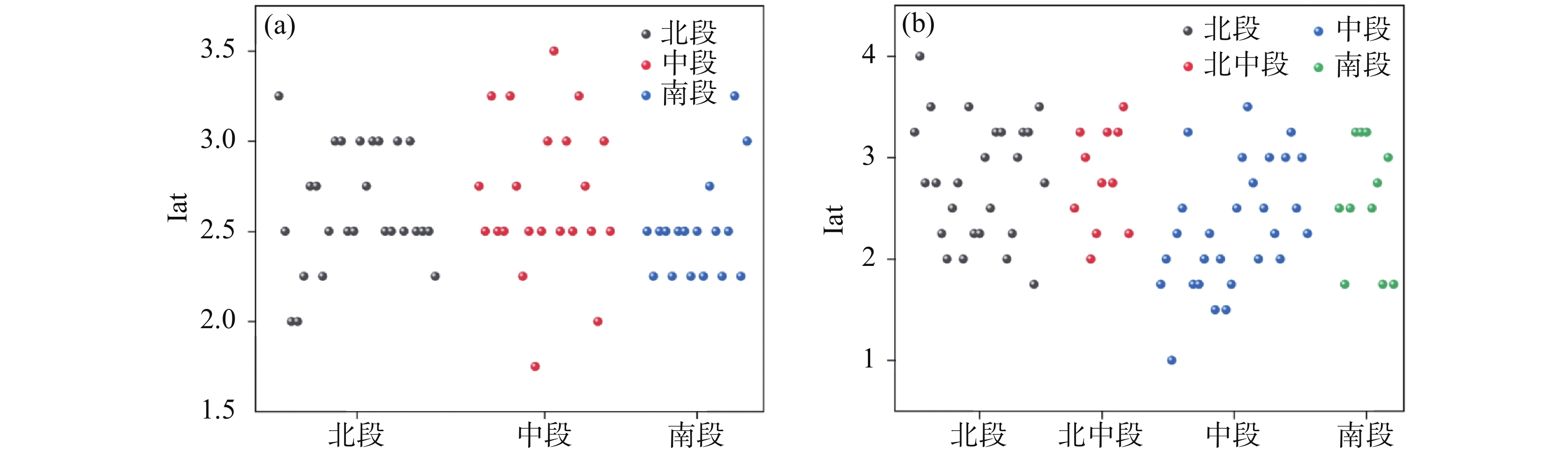
摘要: 区域构造活动强度越大,构造裂隙越发育,三维裂隙空间结构是岩溶水流入渗的优先通道,也是岩溶发育的先导。流域地貌记录了相关的构造活动信息,通过地貌特征参数与裂隙发育规律来预测岩溶的空间分异对岩溶区隧道工程选址及水害防治具有重要意义。文章基于12.5 m DEM数据,利用ArcGIS提取了川东典型背斜区的平均地形坡度(Slope)、面积高程积分(HI)、流域形状指数(BS)、流域盆地延伸率(Re)4个地貌指数,构建相对构造活动强度指数Iat,分析相对构造活动强度与岩溶分异的相关性。结果表明:Iat指数空间分布规律与岩溶空间分异显著相关,可用于指示岩溶分异规律。假角山背斜北段、中段、南段的Iat指数平均值分别为2.68、2.63、2.50,相对构造活动强度为北段>中段>南段;中梁山背斜北段、中段、南段的Iat指数平均值分别为2.80、2.46、2.51,相对构造活动强度为北段>南段>中段。Abstract:
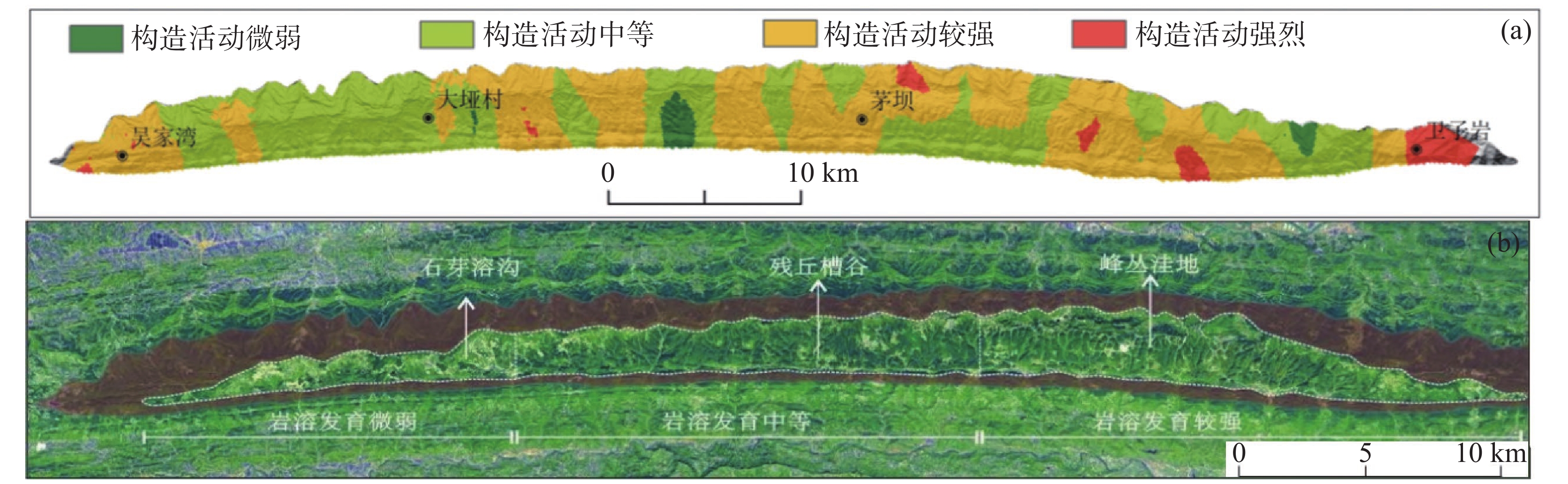
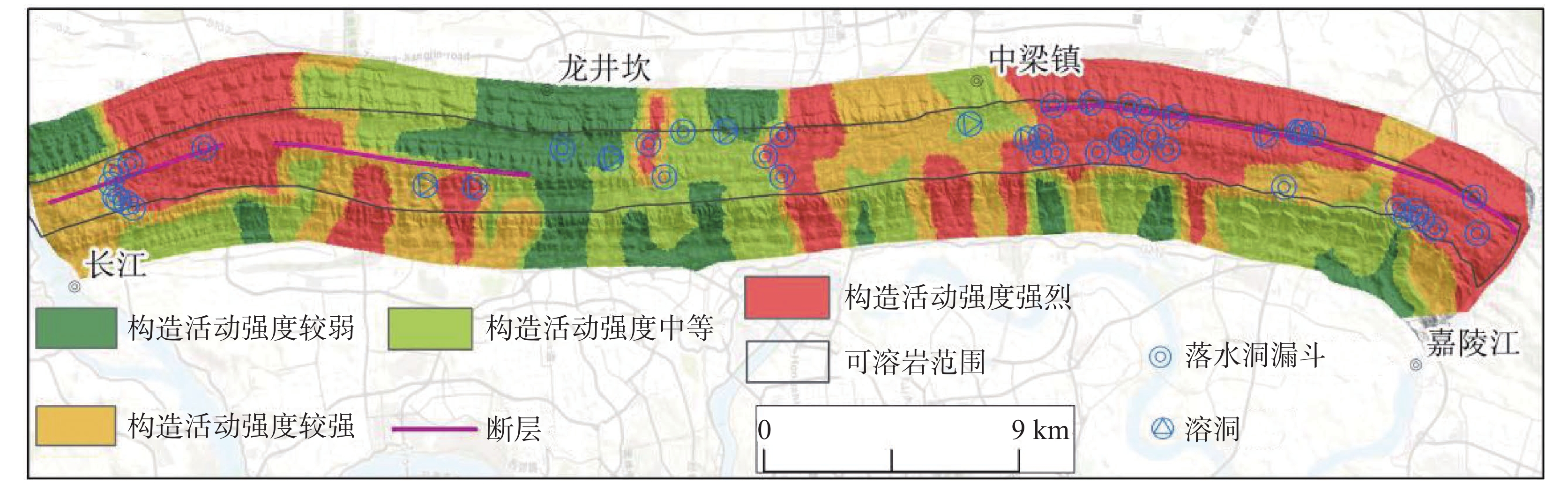
The eastern Sichuan Basin is characterized by a typical ejective fold structure, with parallel anticlinal ridges and synclinal valleys trending NE−SW. Soluble carbonate rocks are extensively exposed in the cores of anticlines, whereas clastic rocks dominate the synclines. The particular karst conditions in these high and steep anticlines frequently lead to severe water inrush disasters during tunnel construction and trigger ecological problems. Routing tunnels to avoid intensely karstified zones is crucial for risk reduction. Previous studies have explored karst differentiation using landforms, drainage networks, fractal analysis, vertical zonation, transverse valley density, and groundwater circulation patterns. Tectonic fractures, especially tensile fractures formed by multi-phase deformation, are considered the principal pathways for early karst infiltration and exert long-term control on modern karst morphology. However, most existing methods rely directly on geomorphological statistics or single tectonic indicators, lacking an intermediate quantitative geomorphic parameter that links tectonic activity to karst development. This study proposes the use of drainage basin geomorphic indices to invert for the relative tectonic activity intensity (Iat). The method is based on the positive feedback mechanism between tectonics and landscape evolution: stronger activity produces more fractures, thus enhancing permeability and dissolution. Surface morphology records integrated neotectonic signals. Its advantages include sensitivity to subtle tectonic differences, readily available DEM data for rapid regional comparisons, and applicability at the early stage of tunnel route selection, reducing reliance on intensive boreholes. The study area is located in the eastern Sichuan tectonic belt, with elevations ranging from 200−300 m in river valleys to over 1500 −2000 m on peaks. Based on the combination of anticlines and through-going valleys, the groundwater flow systems are divided into bilaterally incised, unilaterally incised, and plunging types. We selected the bilaterally incised Zhongliangshan anticline (complex flow system) and the plunging Jiajiaoshan anticline (simple flow system) for comparative analysis. Using 12.5 m resolution ALOS PALSAR DEM data and ArcGIS, sub-basins were delineated—65 in Jiajiaoshan and 75 in Zhongliangshan. Four indices were calculated: mean slope (Slope), hypsometric integral (HI), basin shape index (BS), and elongation ratio (Re). Each index was classified into four classes (1−4), representing extremely weak to extremely strong tectonic activity. Iat is the arithmetic mean of the four class values for each sub-basin, ranging from 1 to 4, with larger values indicating stronger activity. Sub-basin areas range from 0.47 to 6.27 km2 in Jiajiaoshan and from 0.70 to 12.40 km2 in Zhongliangshan; the larger areas in Zhongliangshan reflect stronger headward erosion induced by through-going valleys. The mean Iat values for the northern, central, and southern segments of the Jiajiaoshan anticline are 2.68, 2.63, and 2.50, respectively (north > central > south). The corresponding values for Zhongliangshan are 2.80, 2.46, and 2.51 (north > south > central). Two methods were used for validation. First, in Zhongliangshan, areas with high Iat coincide well with three known faults. Second, karst phenomena observed in field surveys show a strong quantitative correlation with Iat. In the northern segment of Zhongliangshan, Iat is the highest (2.80) and the karst density is the highest (1.42 features/km); the central segment has the lowest Iat (2.46) and the lowest density (0.69 features/km); the southern segment is intermediate (Iat=2.51, density=1.01). The variation of Iat in Jiajiaoshan also matches the observed karst development intensity.Conclusions: (1) Basin-based delineation can effectively reflect the spatial heterogeneity of tectonic activity. (2) The Iat index can distinguish differences between segments within an anticline and among different anticlines. (3) Zones with high Iat values coincide with intensely karstified areas, validating the positive feedback between fracturing and karstification. (4) This geomorphic parameter method provides a useful and low-cost tool for preliminary karst assessment in tunnel planning. However, its accuracy is limited by DEM resolution, and future use of higher-resolution data can improve reliability. -
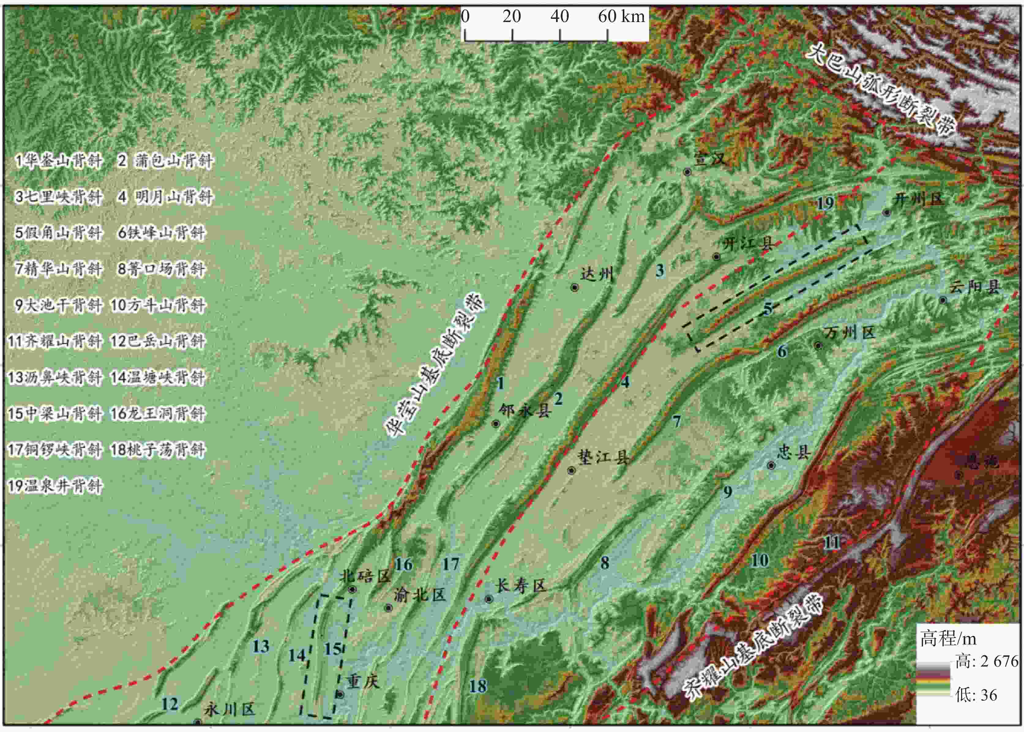
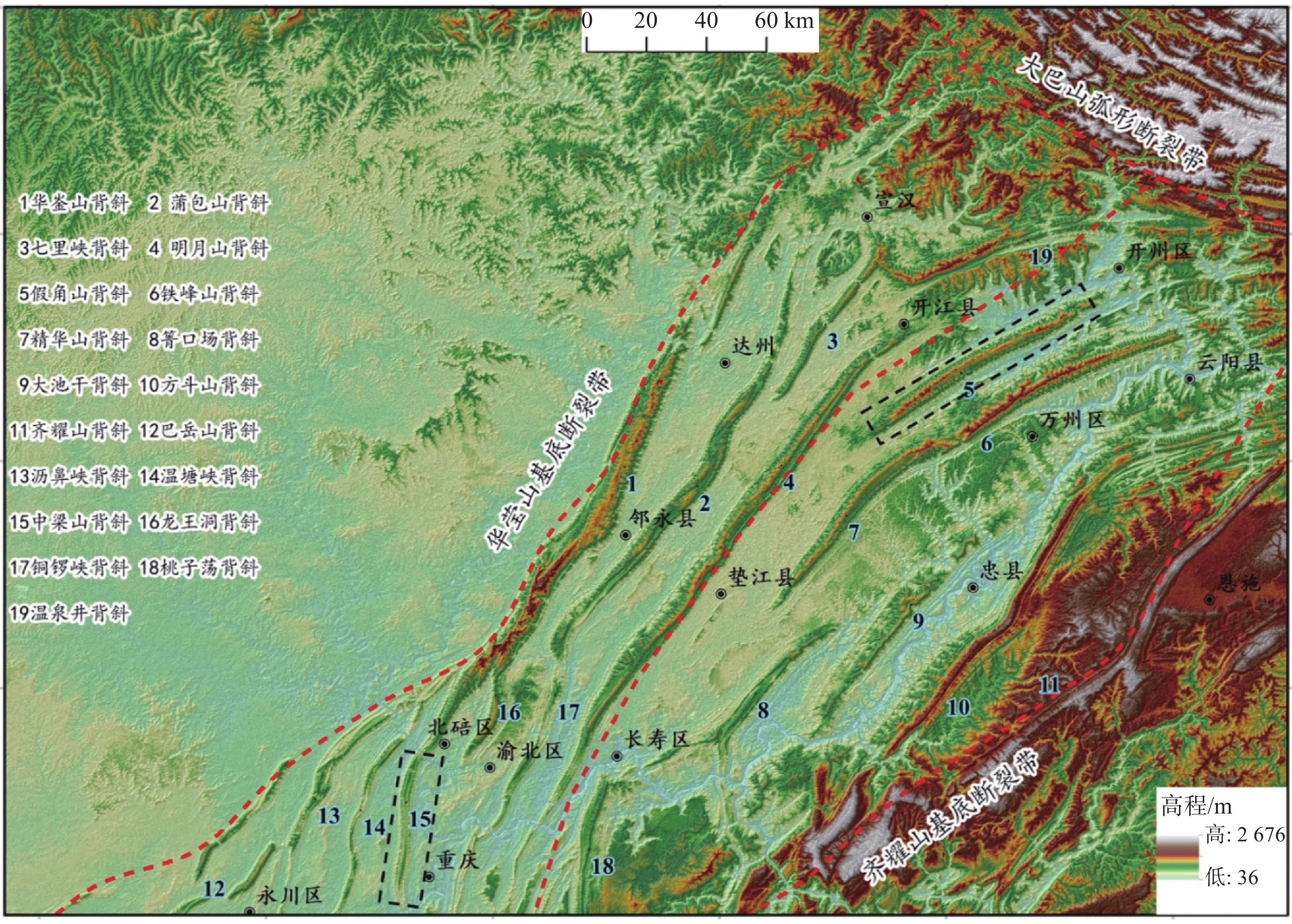
图 1 川东隔挡式构造区地形地貌图
Figure 1. Topographicmap of the compartmentalized structural zone in eastern Sichuan
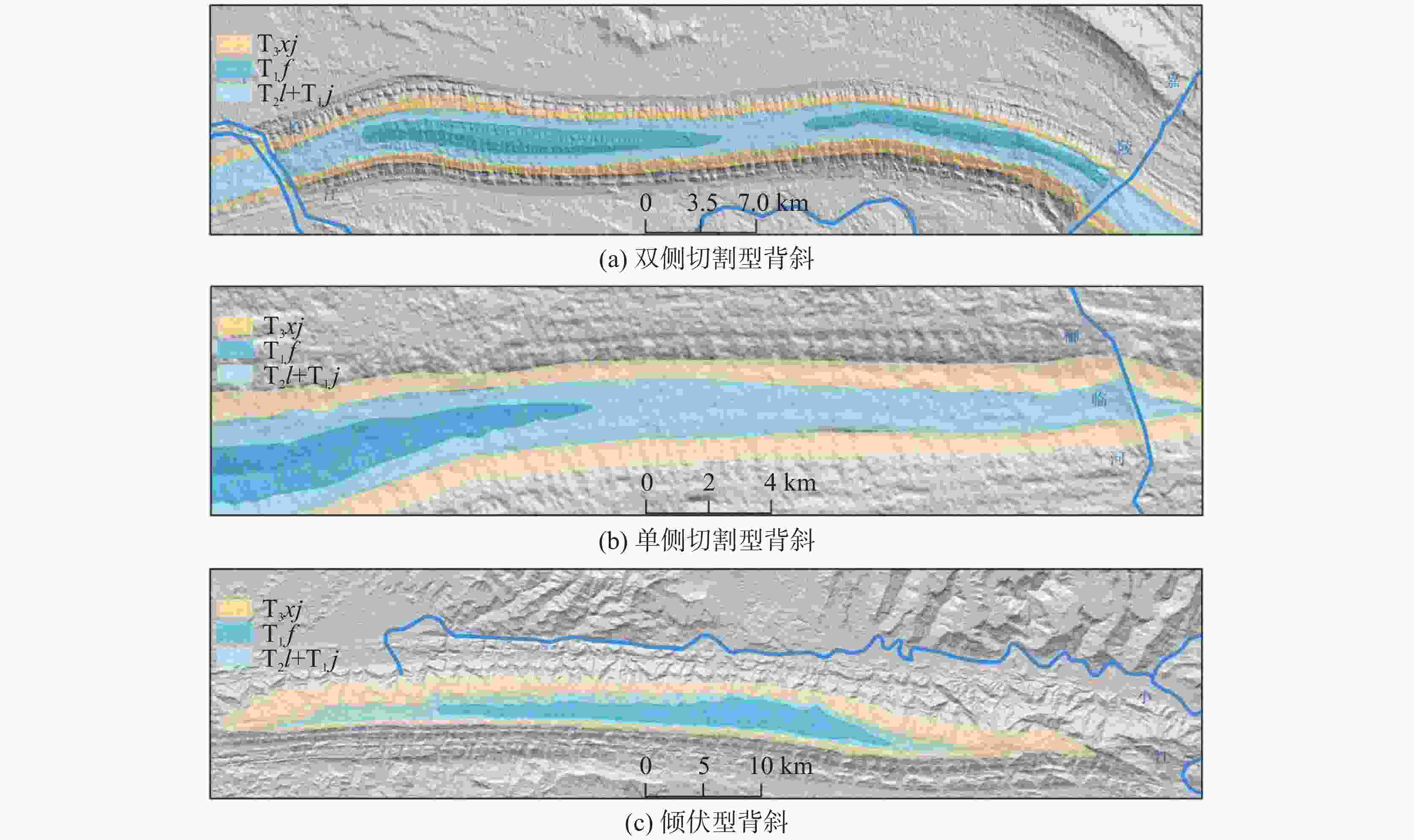
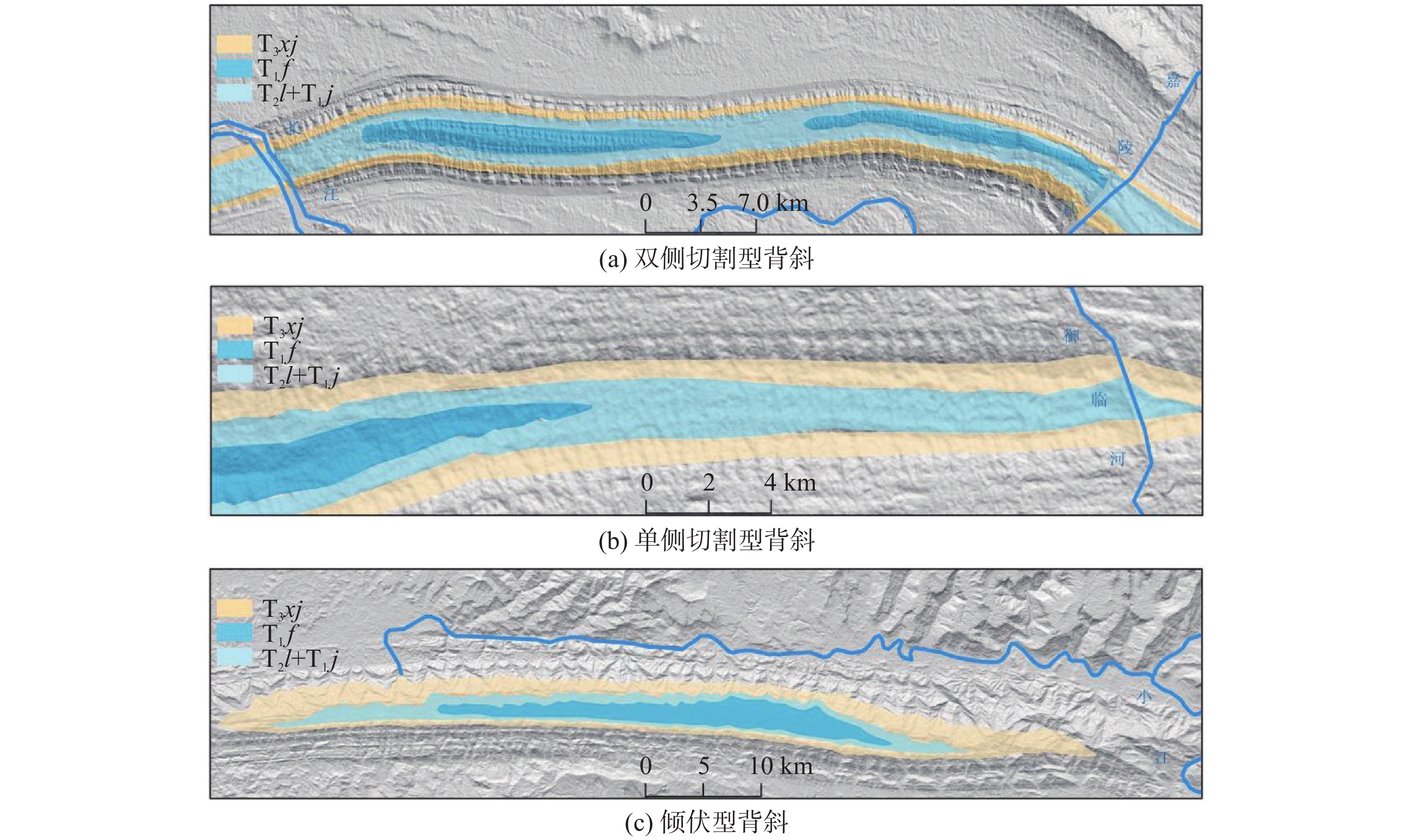
图 2 水文网控制的背斜地下水流模式分类
Figure 2. Classification of anticline groundwater flow patterns controlled by drainage network
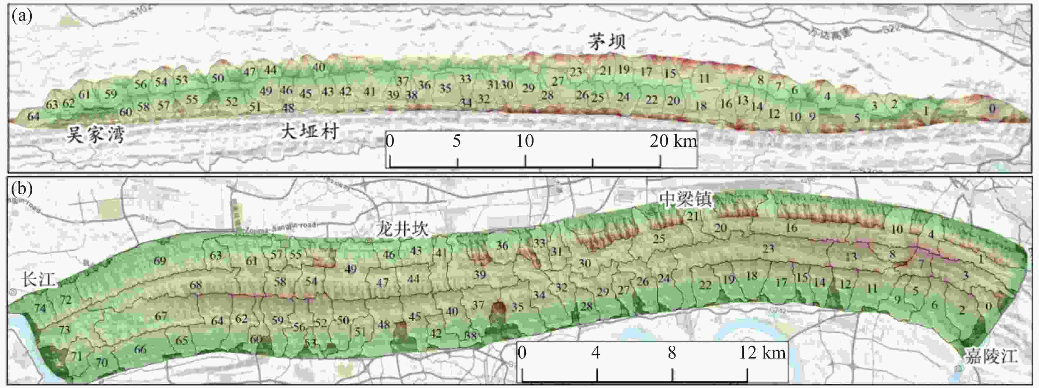
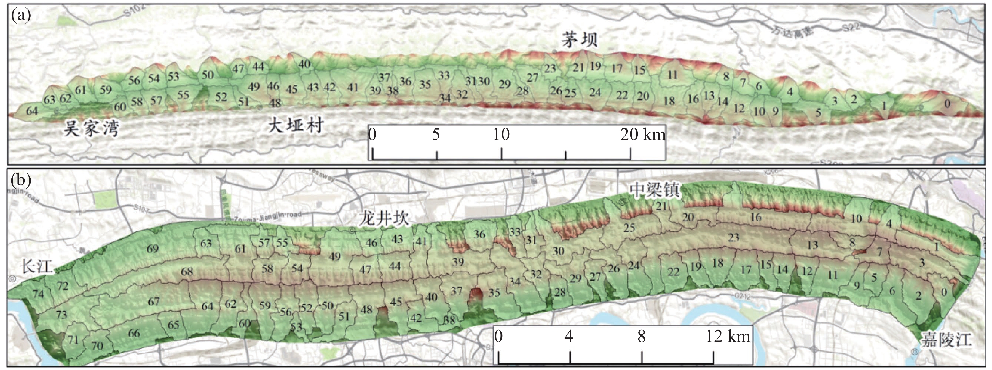
图 3 川东背斜山流域划分平面图(a、假角山背斜流域划分,b、中梁山背斜流域划分)
Figure 3. Drainage basin division map of anticlinal structures in eastern Sichuan (a. Jiajiao Mountain anticline; b. Zhongliang Mountain anticline)
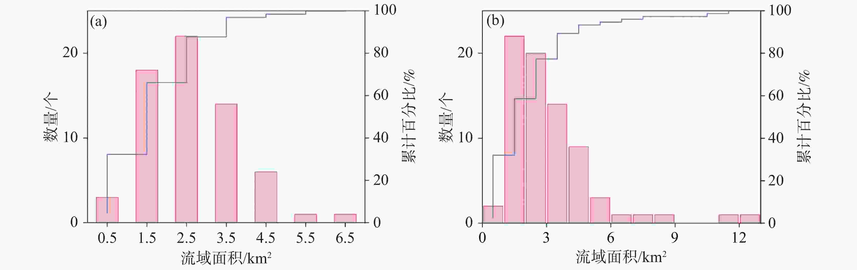
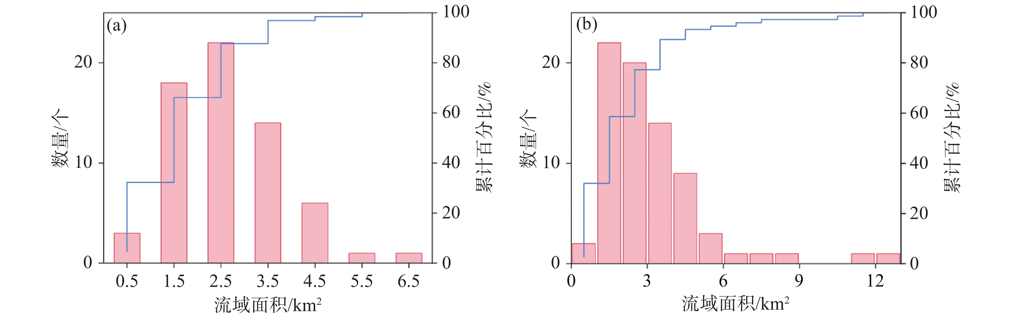
图 4 背斜山流域面积累计百分比图(a、假角山,b、中梁山)
Figure 4. Drainage area cumulative percentage of anticlines (a. Jiajiaoshan; b. Zhongliangshan)
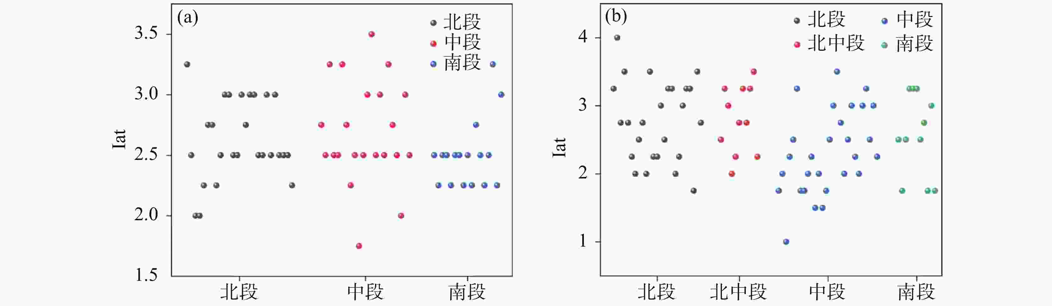
图 7 背斜区相对构造活动强度分布图(a、假角山;b、中梁山)
Figure 7. Spatial distribution of relative tectonic activity in anticlines (a. Jiajiaoshan; b. Zhongliangshan)
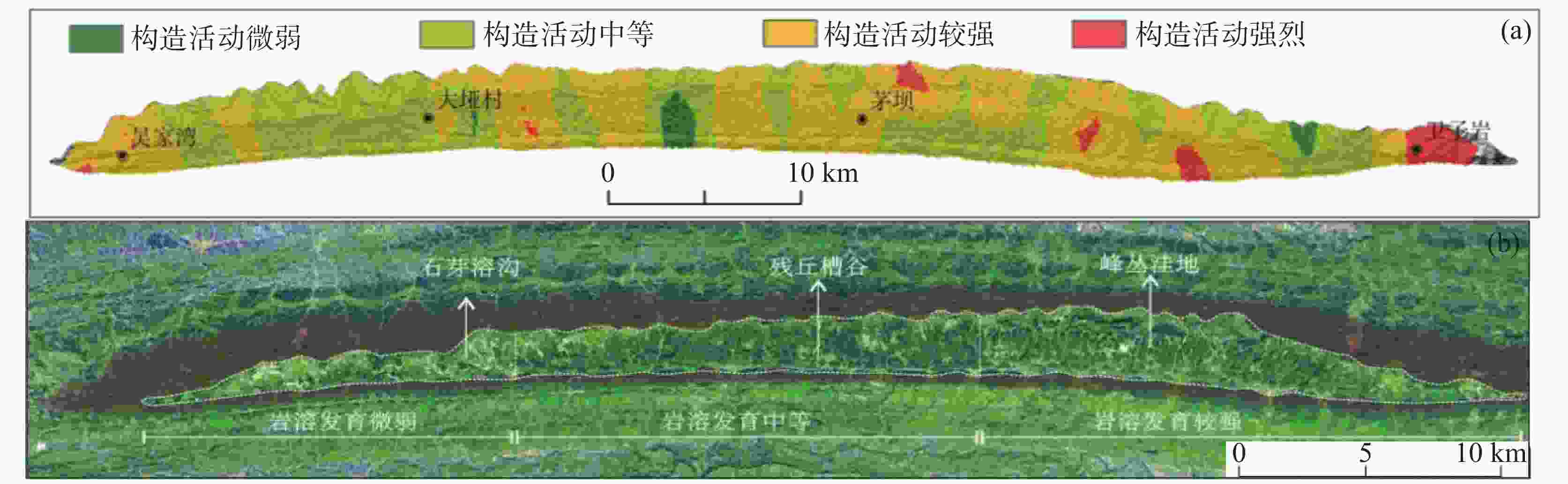
图 8 假角山相对构造活动强度Iat与岩溶空间分异特征对比图
(a、相对构造活动强度平面分布图;b、假角山岩溶空间分异)
Figure 8. Coupling relationship between tectonic activity intensity (iat) and karst spatial heterogeneity in Jiajiaoshan
(a. Spatial distribution of tectonic activity index; b. Karst geomorphic partitioning)
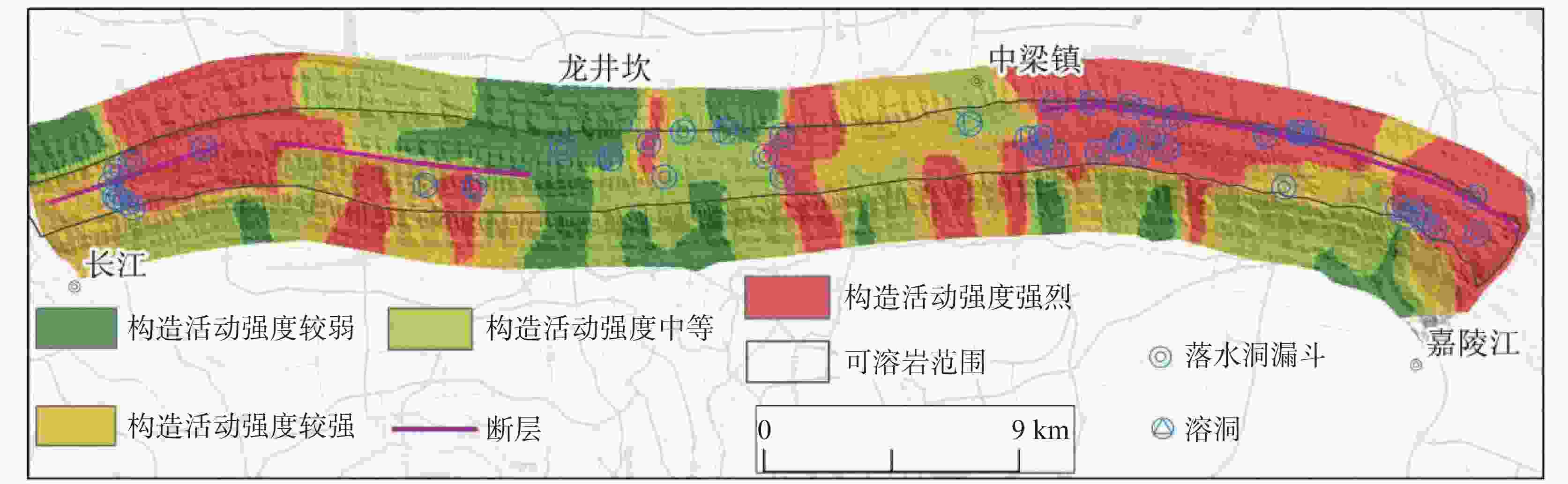
图 9 中梁山相对构造活动强度Iat与岩溶空间分异
Figure 9. Tectono-Karst Coupling Patterns in Zhongliangshan Anticline
表 1 断层与构造活动强度相关性分析
Table 1. Fault-tectonic activity intensity statistical correlation
编号 断层名称 构造强度预测等级 与实际是否吻合 1 白庙子断层 强烈–较强 吻合 2 中梁山断层 较强–中等 吻合 3 猫儿峡断层 强烈–较强 吻合  下载: 导出CSV
表 2 相对构造活动强度与岩溶发育密度的关系
Table 2. Tectonic Activity-Karst Spatial Density Correlation
分段 地区 Iat指数平均值 岩溶发育密度/(个∙km−1) 北段 中梁镇—嘉陵江 2.80 1.42 中段 龙井坎—中梁镇 2.46 0.69 南段 龙井坎—长江 2.51 1.01
下载: 导出CSV
-
[1] 李慧, 魏兴萍, 刘程, 李良鑫. 基于变权重-云模型的岩溶隧道涌突水灾害风险评估: 以中梁山隧道为例[J]. 中国岩溶, 2023, 42(3): 548-557+572.Li Hui, Wei Xingping, Liu Cheng, Li Liangxin. Risk assessment of water inrush disasters of karst tunnels based on variable weight-cloud model: A case study of Zhongliangshan tunnel[J]. Carsologica Sinica, 2023, 42(3): 548-557, 572. [2] 郭宝德, 张毅, 王新文, 陈志高, 董志明, 蒙彦. 基于决策树模型的岩溶隧道涌水可能性快速判断——以桂河高速泗顶特长隧道为例[J]. 中国岩溶, 2024, 43(5): 1156-1165. doi: 10.11932/karst20240512Guo Baode, Zhang Yi, Wang Xinwen, Chen Zhigao, Dong Zhiming, Meng Yan. Rapid assessment of water and mud inrush likelihood in karst tunnels based on decision tree model: A case in Siding tunnel of Guihe expressway[J]. Carsologica Sinica, 2024, 43(5): 1156-1165. doi: 10.11932/karst20240512 [3] 孟杰, 林志斌, 林培忠. 应力−渗流−损伤耦合作用下管道型岩溶隧道突水灾变规律研究[J]. 中国岩溶, 2023, 42(2): 351-360. doi: 10.11932/karst20230206Meng Jie, Lin Zhibin, Lin Peizhong. Research on the law of water inrush disasters in pipeline-type karst tunnels under the coupling effect of stress-seepage-damage[J]. Carsologica Sinica, 2023, 42(2): 351-360. doi: 10.11932/karst20230206 [4] 王涛, 安超杰, 王佐, 许林新. 岩溶地区隧道选线思路与实践[J]. 公路, 2022, 67(5): 25-29.Wang Tao, An Chaojie, Wang Zuo, Xu Linxing. Ideas and practice of tunnel route selection in Karst areas[J]. Highway, 2022, 67(5): 25-29. [5] 曹化平, 王科. 铁路岩溶隧道工程地质选线研究[J]. 高速铁路技术, 2011, 2(1): 31-36. doi: 10.3969/j.issn.1674-8247.2011.01.009Cao Huaping, Wang Ke. Study on geological route selection for railway tunnel engineering in Carst Zone[J]. High Speed Railway Technology, 2011, 2(1): 31-36. doi: 10.3969/j.issn.1674-8247.2011.01.009 [6] 梁福源, 杜云艳, 葛咏, 李策. 峰丛和洼地喀斯特地形定量对比(英文)[J]. Journal of Geographical Sciences, 2014, 24(6): 1069-1082.Liang Fuyuan, Du Yunyan, Ge Yong, Li Ce. A quantitative morphometric comparison of cockpitand doline karst landforms. Journal of Geographical Sciences, 2014, 24(6): 1069-1082. [7] 李苍松, 高波, 梅志荣. 岩溶地质预报的分形理论应用基础研究[J]. 西南交通大学学报, 2007, 20(5): 542-547. doi: 10.3969/j.issn.0258-2724.2007.05.005Li Cangsong, Gao Bo, Mei Zhirong. Basic study on method of Karst geology forecasting based on fractal theory[J]. Journal of Southwest Jiaotong University, 2007, 20(5): 542-547. doi: 10.3969/j.issn.0258-2724.2007.05.005 [8] Cangsong Li, Jianfang Ding, Yankai Liao, Song Lu. 2020. Groundwater Chemical Kinetics and Fractal Characteristics of Karst Tunnel [M]. Singapore: Springer. [9] 申振乾, 杨斌, 胡宽熔, 曹玉清, 刘伦权. 隐伏岩溶区的水文地质分带和定量评价(二): 以山西延河泉域为例[J]. 水文地质工程地质, 1991, (3): 15-17+22.Shen Zhenqian, Yang Bin, Hu Kuanrong, Cao Yuqing, Liu Lunquan. Hydrogeological zoning and quantitative evaluation in concealed karst areas (Part II) : A case study of the Yanhe Spring Catchment in Shanxi. Hydrogeology & Engineering Geology, 1991, (3): 15-17+22. [10] 钟玲敏, 许模, 吴明亮, 杨艳娜, 张强. 多级水流系统耦合下深部岩溶分异研究: 以川东隔挡式构造区中梁山背斜南段为例[J]. 水文地质工程地质, 2018, 45(1): 45-51. doi: 10.16030/j.cnki.issn.1000-3665.2018.01.07Zhong Lingmin, Xu Mo, Wu Mingliang, Yang Yanna, Zhang Qiang. Development of deep karst under the coupling of multistage flow systems: A case of southern part of the Zhongliang Mountain anticline of the parallel barrier structure in Eastern Sichuan[J]. Hydrogeology & Engineering Geology, 2018, 45(1): 45-51. doi: 10.16030/j.cnki.issn.1000-3665.2018.01.07 [11] 李源. 塔河油田奥陶系岩溶储层发育与海西早期水文地貌响应关系研究[D]. 武汉: 中国地质大学, 2016.Li Yuan. Relationship between the development of Ordovician karst reservoir and Hydrogeomorphologic in Hercynian, Tahe Oilfield [D]. Wuhan: China University of Geosciences, 2016. [12] 成胜, 许模, 杨艳娜, 张贵铜, 黄思霜. 川东褶皱带明月峡背斜区地下岩溶发育规律[J]. 长江科学院院报, 2020, 37(11): 114-120. doi: 10.11988/ckyyb.20190832Cheng Sheng, Xu Mo, Yang Yanna, Zhang Guitong, Huang Sishuang. Development Rules of Underground Karst in the Mingyue Gorge Anticline Area of the Eastern Sichuan Tectonic Belt[J]. Journal of Changjiang River Scientific Research Institute, 2020, 37(11): 114-120. doi: 10.11988/ckyyb.20190832 [13] 黄思霜, 许模, 杨艳娜, 成胜, 张贵铜. 川东高陡背斜区水文网控制的地下岩溶空间分异研究[J]. 山地学报, 2020, 38(1): 83-92. doi: 10.16089/j.cnki.1008-2786.000493Huang Sishuang, Xu Mo, Yang Yanna, Cheng Sheng, Zhang Guitong. Spatial Differentiation of Underground Karst Controlled by Hydrological Network in High-Steep Anticline in Eastern Sichuan, China[J]. Mountain Research, 2020, 38(1): 83-92. doi: 10.16089/j.cnki.1008-2786.000493 [14] 吴泓瑶, 杨艳娜, 曾宪明, 刘洋. 基于水动力量化因子的岩溶强发育深度研究[J]. 地质科技通报, 2022, 41(1): 319-327. doi: 10.19509/j.cnki.dzkq.2022.0027Wu Hongyao, Yang Yanna, Zeng Xianming, Liu Yang. Depth of strong development of karst based on quantitative factors of hydrodynamic conditions[J]. Bulletin of Geological Science and Technology, 2022, 41(1): 319-327. doi: 10.19509/j.cnki.dzkq.2022.0027 [15] 余磊, 杨艳娜, 许模, 贺苏和巴特尔, 曾宪明, 刘洋. 川东明月峡背斜区岩溶形态分异与构造裂隙表征参数的关系[J]. 成都理工大学学报(自然科学版), 2023, 50(1): 92-100.Yu Lei, Yang Yanna, Xu Mo, He Suhebateer, Zeng Xianming, Liu Yang. 2023. Relationship between karst morphology differentiation and structural fracture characterization parameters in Mingyuexia anticline area, eastern Sichuan Basin, China. Journal of Chengdu University of Technology (Science & Technology Edition), 50(1): 92-100. [16] 戴岩. 基于DEM的青藏高原东北缘宛川河流域地貌的定量表达与新构造活动分析[D]. 南京: 南京大学, 2017.Dai Yan. Quantitative Analysis of morphology and its Neotectonic implication in the Wanchuan catchment based on Digital Elevation Models[D]. Nanjing: Nanjing University, 2017. [17] 李勇杰, 周小虎, 尤继元, 胡金鑫, 黄琪. 北大巴山汉江流域地貌特征及其构造意义[J]. 地质科学, 2024, 59(4): 1132-1150.Li Yongjie, Zhou Xiaohu, You Jiyuan, Hu Jinxin, Huang Qi. 2024. Geomorphic feature and tectonic implications of the Hanjiang River basin in the northern Dabashan. Chinese Journal of Geology, 59(4): 1132-1150. [18] 黄峰, 熊仁伟, 林敬东, 赵峥, 杨攀新. 嘉黎断裂带中段流域地貌形态指数与新构造活动特征[J]. 地震, 2024, 44(1): 1-18. doi: 10.12196/j.issn.1000-3274.2024.01.001Huang Feng, Xiong Renwei, Lin Jingdong, Zhao Zheng, Yang Panxin. Geomorphic Index and Activity Characteristics of the Mid-Segment of Jiali Fault[J]. Earthquake, 2024, 44(1): 1-18. doi: 10.12196/j.issn.1000-3274.2024.01.001 [19] 田鹏, 周青云, 白仙富, 罗伟东, 刘婧楠. 滇西南把边江断裂带流域地貌特征与构造活动的关系[J]. 现代地质, 2025, 39(4): 898-907. doi: 10.19657/j.geoscience.1000-8527.2024.129Tian Peng, Zhou Qingyun, Bai Xianfu, Luo Weidong, Liu Jingnan. Fluvial geomorphological characteristics and their relationship with tectonic activity in the Babianjiang Fault Zone, Southwest Yunnan[J]. Geoscience, 2025, 39(4): 898-907. doi: 10.19657/j.geoscience.1000-8527.2024.129 [20] 高泽民, 刘兴旺, 邵延秀, 邹小波. 地貌参数揭示的三危山构造活动性差异及其原因探讨[J]. 地震工程学报, 2021, 43(1): 70-78. doi: 10.3969/j.issn.1000-0844.2021.01.070Gao Zemin, Liu Xingwang, Shao Yanxiu, Zou Xiaobo. Differential Tectonic Activities of Sanweishan Area Revealed by Geomorphic Parameters and Its Causes[J]. China Earthquake Engineering Journal, 2021, 43(1): 70-78. doi: 10.3969/j.issn.1000-0844.2021.01.070 [21] 王阳, 周小虎, 史小辉, 黄琪, 刘禄山. 青藏高原东北缘清水河流域地貌特征及其构造意义[J]. 成都理工大学学报(自然科学版), 2024, 51(4): 579-595.Wang Yang, Zhou Xiaohu, Shi Xiaohui, Huang Qi, Liu Lushan. 2024. Geomorphic features of the Qingshui River Basin and their significance for the northeastern margin of the Qinghai-Tibet Plateau. Journal of Chengdu University of Technology (Science & Technology Edition), 51(4): 579-595. [22] 余华玉, 董有浦, 于良, 张东越, 王丹, 段佳鑫, 任洋洋, 李江涛. 滇中普渡河断裂相对构造活动性特征[J]. 地球科学, 2025, 50(1): 336-348. doi: 10.3799/dqkx.2022.172Yu Huayu, Dong Youpu, Yu Liang, Zhang Dongyue, Wang Dan, Duan Jiaxin, Ren Yangyang, Li Jiangtao. Relative Tectonic Activity of Puduhe Fault in Central Yunnan[J]. Earth Science, 2025, 50(1): 336-348. doi: 10.3799/dqkx.2022.172 [23] 陈宏峰, 张发旺, 何愿, 夏日元, 邹胜章, 苏春田, 罗书文. 地质与地貌条件对岩溶系统的控制与指示[J]. 水文地质工程地质, 2016, 43(5): 42-47. doi: 10.16030/j.cnki.issn.1000-3665.2016.05.06Chen Hongfeng, Zhang Fawang, He Yuan, Xia Riyuan, Zou Shengzhang, Su Chuntian, Luo Shuwen. Geological and geomorphologic settings acting as the controlling factors and indicators for karst systems[J]. Hydrogeology & Engineering Geology, 2016, 43(5): 42-47. doi: 10.16030/j.cnki.issn.1000-3665.2016.05.06 [24] 王杨双. 川东高陡褶断带构造地貌特征及岩溶发育强度研究[D]. 成都: 成都理工大学, 2023.Wang Yangshuang. Research on the Morphotectonics Characteristics and Regional Karst Development of High-steep Anticlime in the Eastern Sichuan Fold-Thrust Belt[D]. Chengdu: Chengdu University of Technology, 2023. [25] 孙林龙, 董有浦, 吴中海, 张世涛, 李立, 刘志明. 基于河流地貌指数的澜沧江断裂南段构造活动性研究[J]. 地质科学, 2024, 59(6): 1543-1561.Sun Linlong, Dong Youpu, Wu Zhonghai, Zhang Shitao, Li Li, Liu Zhiming. 2024. Study on tectonic activity of the southern Lancang River fault based on the stream geomorphic index. Chinese Journal of Geology, 59(6): 1543-1561. [26] 魏英豪, 陈素娟, 王学良, 王俊飞, 金超, 郭松峰, 李兆, 田乙茜. 基于构造地貌法的滇中引水工程区全新世断裂活动强度空间差异性研究[J]. 地质科学, 2025, 60(1): 293-307.Wei Yinghao, Chen Sujuan, Wang Xueliang, Wang Junfei, Jin Chao, Guo Songfeng, Li Zhao, Tian Yiqian. 2025. Spatial variability of Holocene fracture activity intensity in the central Yunnan water diversion project area based on the tectonic geomorphological method. Chinese Journal of Geology, 60(1): 293-307. [27] 苏琦, 袁道阳, 谢虹, 邵延秀, 梁明剑. 祁连山西段疏勒河流域地貌特征及其构造意义[J]. 地震地质, 2016, 38(2): 240-258. doi: 10.3969/j.issn.0253-4967.2016.02.002Su Qi, Yuan Daoyang, Xie Hong, Shao Yanxiu, Liang Mingjian. Geomorphic features of the Shule River Drainage basin in Qilianshan and its insight into tectonic implications[J]. Seismology and Geology, 2016, 38(2): 240-258. doi: 10.3969/j.issn.0253-4967.2016.02.002 [28] 路芳, 高明星, 周书贤, 王顺. 阿尔金东段断裂带流域地貌特征及其构造活动[J]. 现代地质, 2023, 37(5): 1100-1109. doi: 10.19657/j.geoscience.1000-8527.2023.020Lu Fang, Gao Mingxing, Zhou Shuxian, Wang Shun. Fluvial Geomorphology of the Eastern Altyn Tagh and Its Tectonic Activity Implications[J]. Geoscience, 2023, 37(5): 1100-1109. doi: 10.19657/j.geoscience.1000-8527.2023.020 [29] 刘樯漪, 程维明, 郭良, 孙东亚. 北天山流域地貌特征及其构造活动分析[J]. 地理与地理信息科学, 2017, 33(4): 79-85. doi: 10.3969/j.issn.1672-0504.2017.04.014Liu Qiangyi, Cheng Weiming, Guo Liang, Sun Dongya. Geomorphology of Northern Tianshan and Its Structural Analysis[J]. Geography and Geo-Information Science, 2017, 33(4): 79-85. doi: 10.3969/j.issn.1672-0504.2017.04.014 [30] 温宇航. 构造隆升速率对岷江上游流域地貌的影响研究[D]. 绵阳: 西南科技大学, 2024.Wen Yuhang. Study on the impact of tectonic uplift rate on the landforms of the upper reach of the Minjiang River[D]. Mianyang: Southwest University of Science and Technology, 2024. [31] Gimenez V B, Salamuni E, Dos Santos J M, Peyerl W R L, Farias T F S, Sanches E. The role of fault reactivation in the geomorphological evolution of coastal landforms on passive continental margins: Evidence from a tectonic estuary in southern Brazil[J]. Geomorphology, 2022, 402. [32] 徐伟, 刘志成, 袁兆德, 高战武, 杨源源. 华山山前河流地貌参数及其构造意义[J]. 地震地质, 2017, 39(6): 1316-1335. doi: 10.3969/j.issn.0253-4967.2017.06.015Xu Wei, Liu Zhicheng, Yuan Zhaode, Gao Zhanwu, Yang Yuanyuan. River geomorphic parameters of the Huashan piedmont and their tectonic implications[J]. Seismology and Geology, 2017, 39(6): 1316-1335. doi: 10.3969/j.issn.0253-4967.2017.06.015 -

 点击查看大图
计量
- 文章访问数: 5
- HTML浏览量: 3
- PDF下载量: 0
- 被引次数: 0
