

Spatial and temporal distribution characteristics of geological disasters and research on disaster−causing factors in Dali Prefecture
-
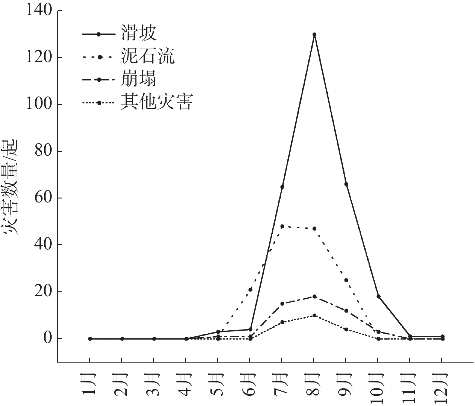
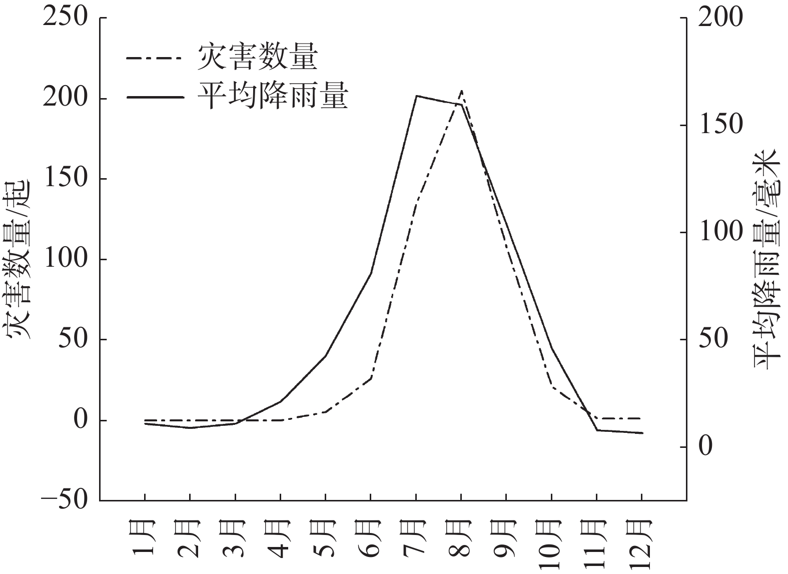
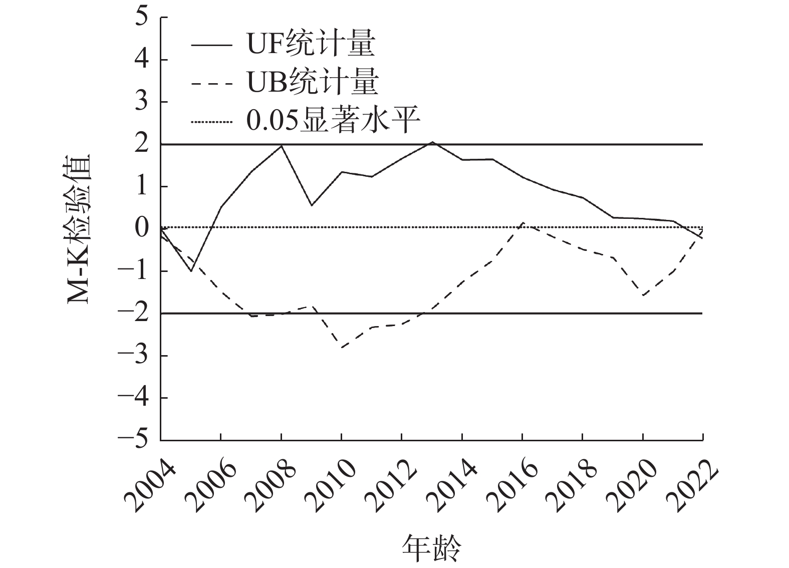
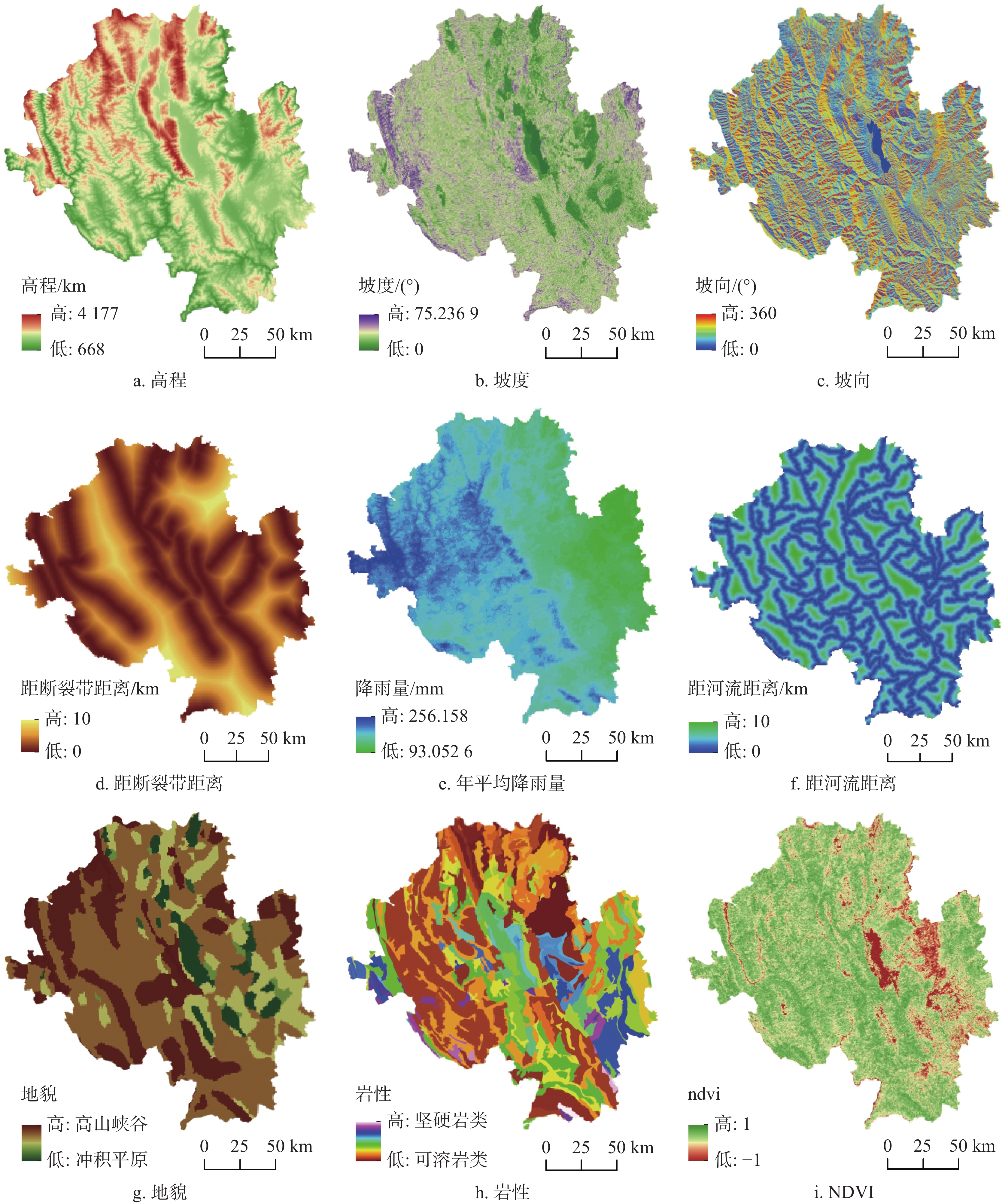
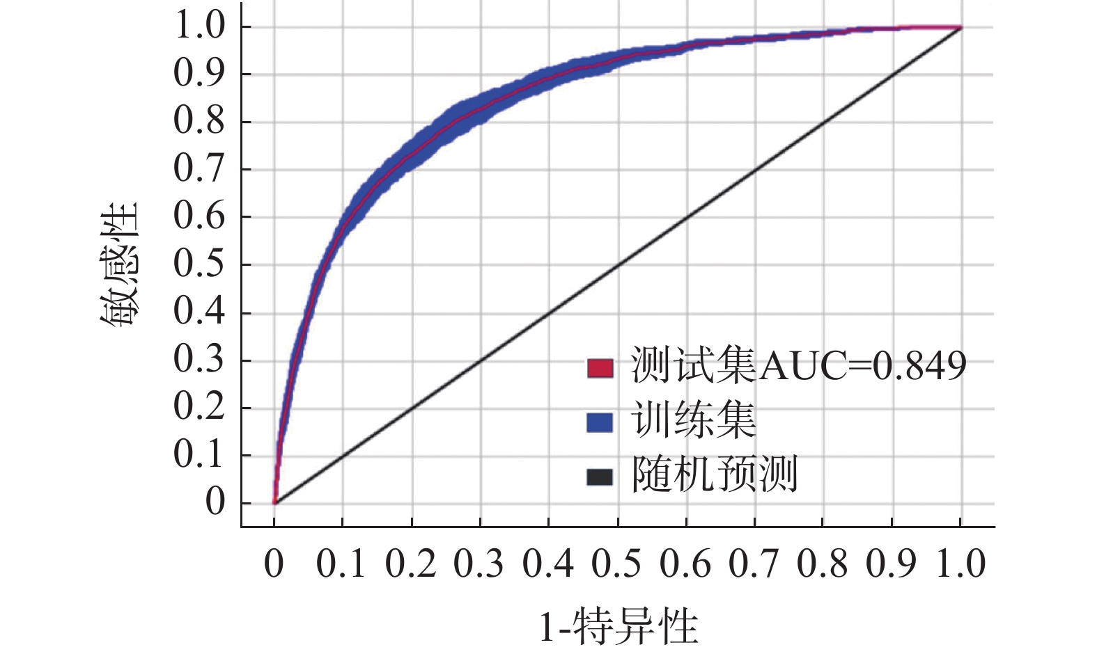
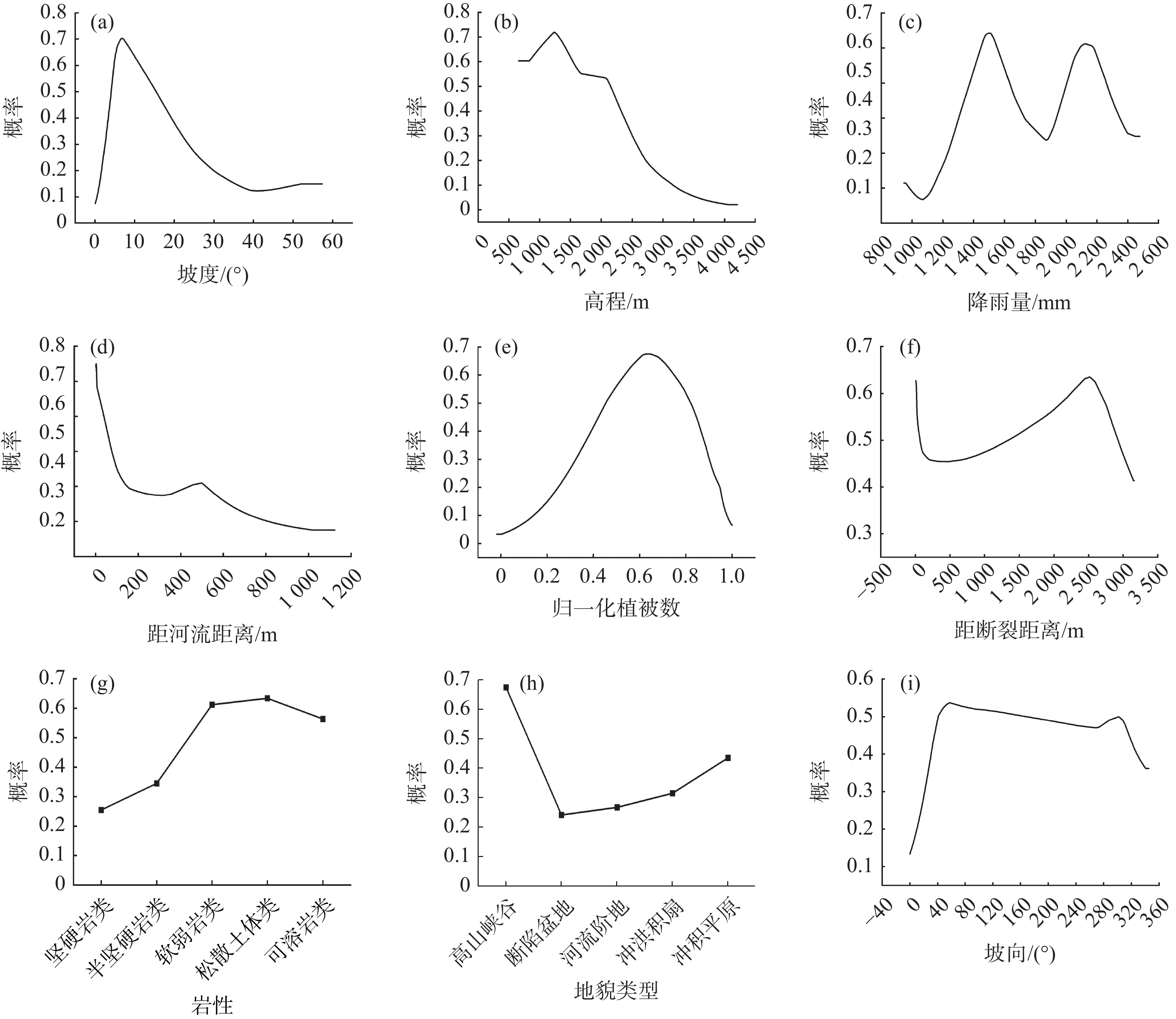
摘要: 文章针对滇西高原地质灾害频发问题,基于大理州2004—2022年501起地质灾害详实数据,融合GIS空间分析、Mann−Kendall趋势检验、时空热点演化及最大熵物种分布模型(MaxEnt)等多元方法,实现了大理州地质灾害时空分异规律与致灾机制的协同解译。结果表明:(1)时间上灾害集中于6−10月(占98.6%),年际变化未呈现显著趋势性突变;(2)空间上呈现“北密南疏”格局,热点区由东北向西部迁移,鹤庆县、云龙县及洱源县为高风险聚集区;(3)MaxEnt模型揭示坡度、高程、降雨量与距河流距离为关键致灾因子,贡献度均超过14%,其中降雨量的独立重要性最高达22.7%;致灾因子响应曲线进一步揭示:坡度约10°、高程
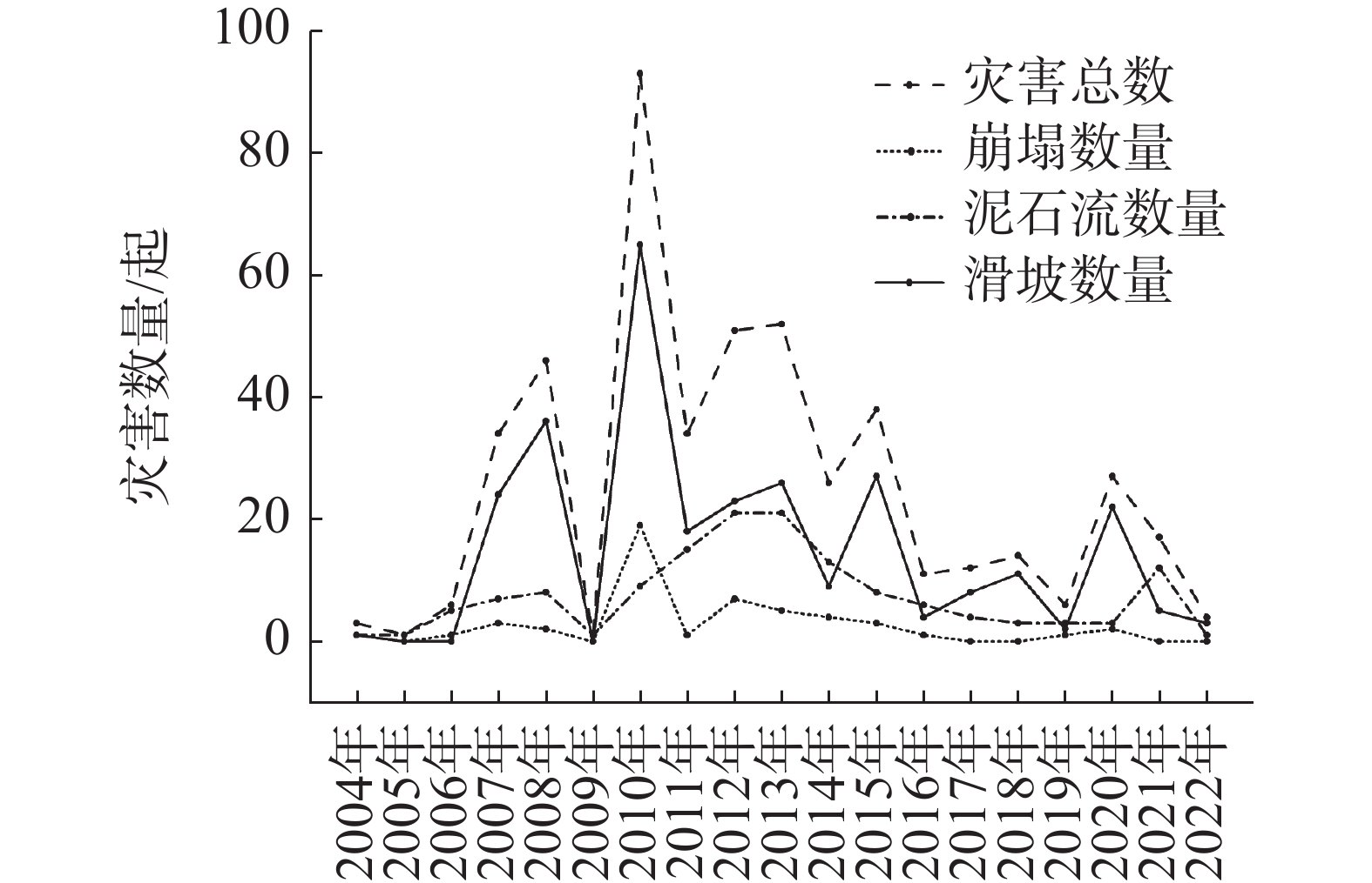
1200 ~2000 m、年降雨量800~1600 mm、距河流200 m以内、归一化植被数(NDVI)在0.6−0.8之间为灾害高敏感阈值,断裂带邻近区、软弱岩及松散土体分布区以及高山峡谷地区灾害风险较高。结果可为大理州地质灾害防控提供定量依据。Abstract:T Dali Bai Autonomous Prefecture is located in the central-western part of Yunnan Province, spanning the four major river systems of the Jinsha River, Lancang River, Nujiang River, and Honghe River. Geologically situated at the junction of the Yangtze Craton and the Lanping-Simao Fold Belt, the region exhibits intense tectonic activity, well-developed faults, and complex lithology. Controlled by the Hengduan Mountains, the terrain slopes from northwest to southeast. The western region comprises the Yunling high-mountain gorge zone, exhibiting tectonic-eroded high-mountain topography. The eastern part features broad, gentle mountain basins dominated by tectonic-eroded medium-mountain and hilly landscapes. The central area is characterized by alluvial-lacustrine and fluvial-alluvial deposits. Under the combined influence of tectonics and geomorphology, geological hazards in this region exhibit diverse types, high frequency and intensity, significant spatial differentiation, and complex temporal variations. To systematically reveal the spatiotemporal distribution patterns and dominant factors of geological hazards in Dali Prefecture, this study established a three-dimensional analytical framework: “spatiotemporal pattern identification—quantification of evolutionary trends—analysis of hazard mechanisms.” Integrated methods including GIS spatial analysis (kernel density estimation and temporal overlay), Mann−Kendall trend tests, spatiotemporal hotspot evolution analysis, and the Maximum Entropy (MaxEnt) species distribution model were employed to quantitatively identify and analyze the spatiotemporal patterns, evolution, and triggering mechanisms of geological hazards. Results indicate: Landslides exhibit approximately 5-year periodic peaks, while debris flows follow roughly 10-year cycles. 98.6% of events occur between June and October, peaking in August, with disaster frequency significantly positively correlated with monthly precipitation. Spatially, a “dense north, sparse south” pattern emerged, with high-risk zones primarily clustered in Heqing, Yunlong, and Eryuan counties. Further analysis indicates that the spatiotemporal evolution of geological hazards in Dali Prefecture generally follows a “fluctuation-gradual change” pattern, with a potential trend inflection point around 2016. Spatial hotspots show an overall strengthening trend, migrating westward from Heqing to Eryuan and then to Yunlong. The MaxEnt model identifies topography and rainfall as primary controlling factors, with slope, elevation, annual precipitation, and distance from rivers as the four key contributing factors, collectively accounting for 63.8% of the total variation. Key thresholds for high-sensitivity zones are: a slope of about 10°; an elevation range of 1200 —2000 m; an annual precipitation of 800—1600 mm; a proximity to rivers of less than 200 m; and an NDVI between 0.6 and 0.8. Fault zones, areas with weak rock formations, and high-mountain canyon regions constitute highly sensitive zones for geological hazards.These findings provide decision-making support for optimizing territorial spatial planning, developing geological hazard prevention strategies, and deploying emergency response resources in Dali Prefecture. -
Key words:
- geological disasters /
- spatiotemporal distribution /
- MaxEnt /
- hazard factor /
- Dali
-
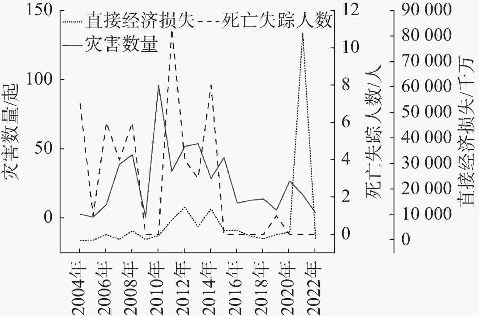
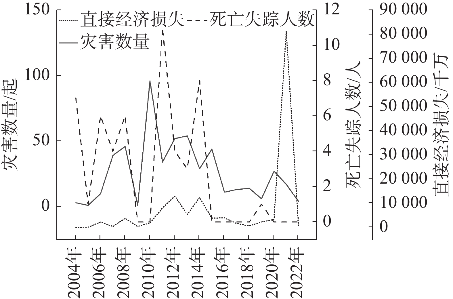
图 2 死亡失踪人数与直接经济损失图
Figure 2. Direct economic losses versus the number of fatalities and missing persons
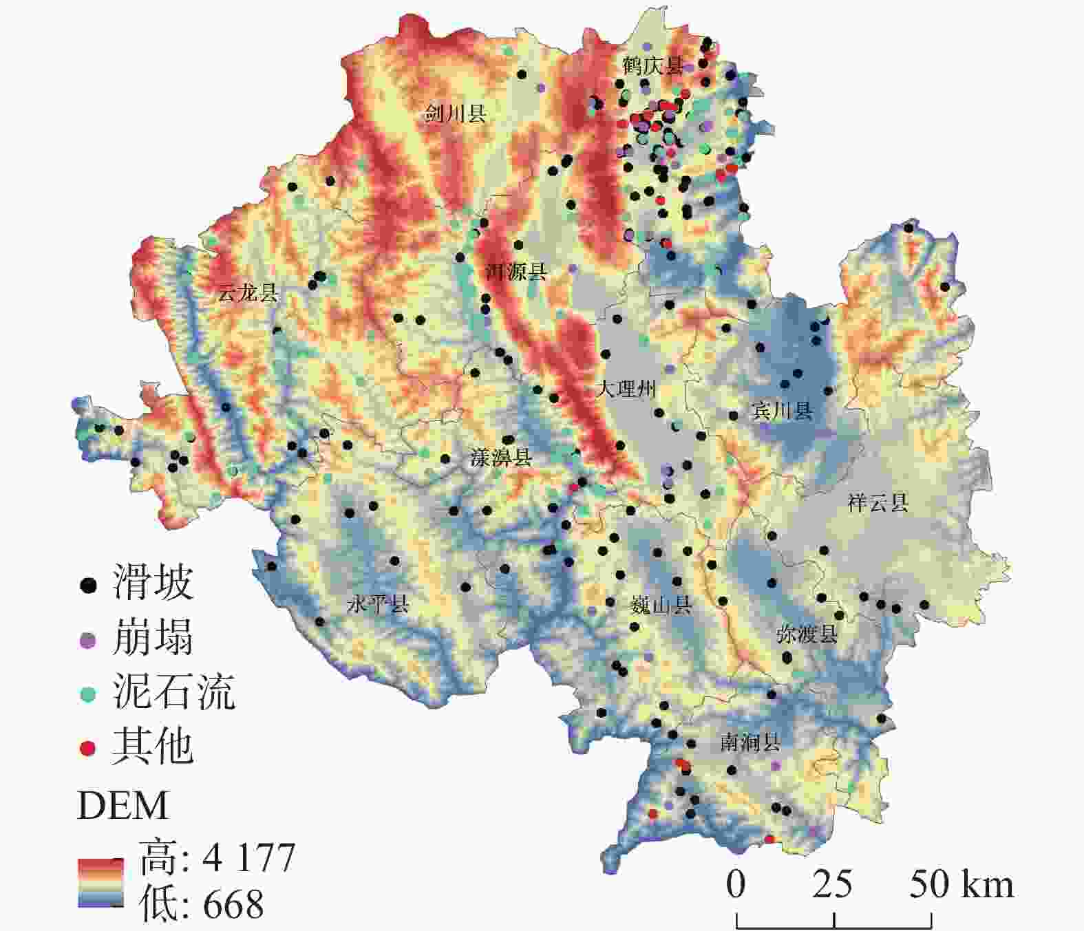
图 6 地质灾害空间分布
注:该底图基于国家地理信息公共服务平台网站下载的审图号为GS(2024)0650号的标准地图制作,底图无修改,后同。Note: This base map is produced based on the standard map with review number GS (2024) 0650 downloaded from the National Geographic Information Public Service Platform website. The base map has not been modified.
Figure 6. Spatial distribution of geohazards
表 1 地质灾害灾情基本情况表
Table 1. Basic statistics of geohazard impacts
灾情类型 崩塌 滑坡 泥石流 地面塌陷 地裂缝 地面沉降 数量/起 50 288 142 5 11 5 占比/% 10 57.5 28.3 1 2.2 1  下载: 导出CSV
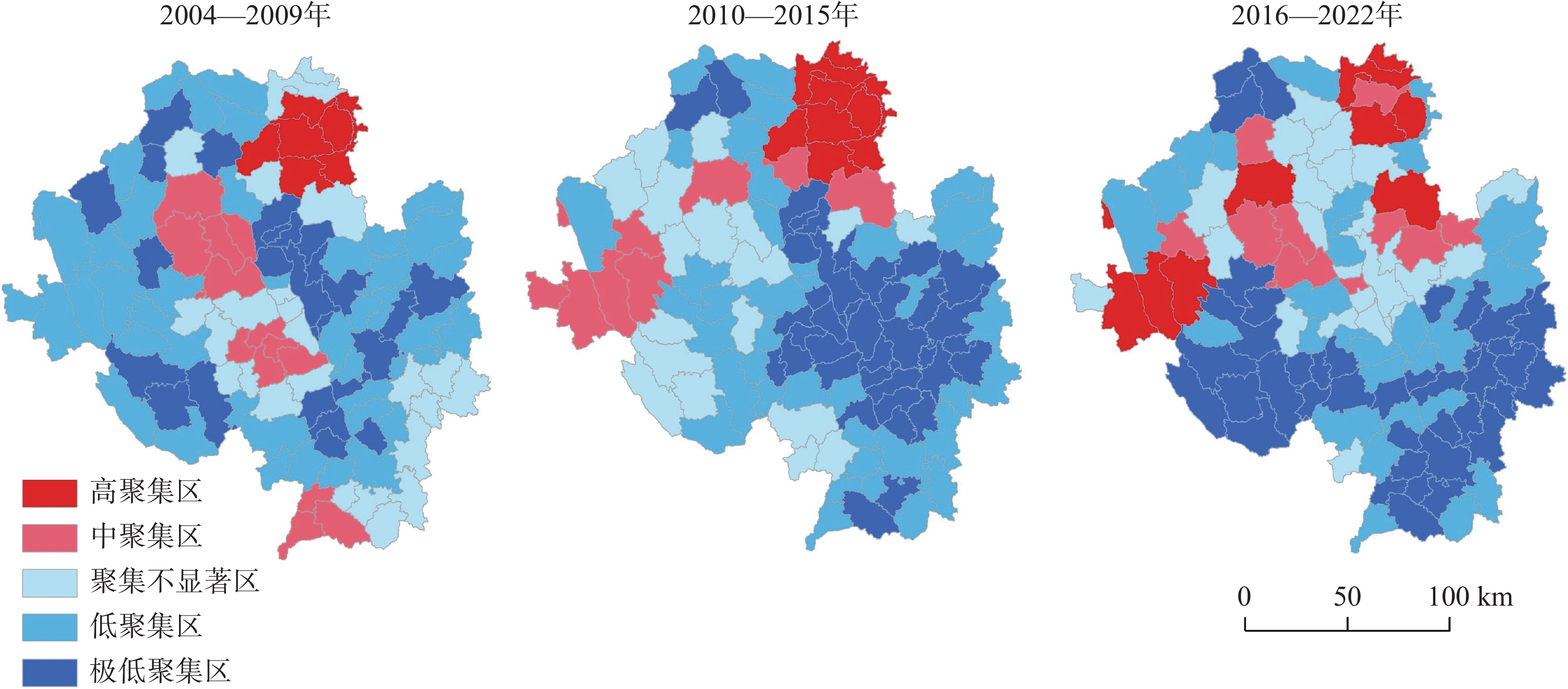
表 2 三时段演变特征
Table 2. Evolutionary characteristics for the three periods
时段/年 北部 中部 南部 2004−2009 高聚集区集中在东边鹤庆−剑川,中聚集区位于洱源,自东向西强调降低 以漾濞中聚集区为中心,东西两侧聚集不显著至低聚集 低聚集区为主,最南部南涧局部地区为中聚集区 2010−2015 高聚集区范围扩大,热点增强并向西部云龙扩散 强度进一步降低,以极低−低聚集区为主 强度较低,以低聚集为主,南涧由中聚集区转变为低聚集区 2016−2022 东边鹤庆高聚集区向南边扩散,中间的洱源和西边的云龙强调增大,出现高聚集区 强度增强,热点东移,中间的大理市和东边的宾川局部出现中部聚集 强度进一步降低,以极低聚集区为主
下载: 导出CSV
表 3 环境变量贡献度和重要性
Table 3. Importance of predictor variables
影响因子 贡献度/% 重要程度/% 坡度 19.75 16.62 高程 14.98 19.94 年平均降雨量 14.54 22.69 距河流距离 14.53 5.51 NDVI 13.93 8.57 岩性 11.63 12.84 地貌类型 4.81 3.60 距断裂带距离 3.87 6.31 坡向 1.96 3.93
下载: 导出CSV
-
[1] 杜悦悦, 彭建, 赵士权, 胡智超, 王仰麟. 西南山地滑坡灾害生态风险评价——以大理白族自治州为例[J]. 地理学报, 2016, 71(9): 1544-1561.DU Yueyue, PENG Jian, ZHAO Shiquan, HU Zhichao, WANG Yanglin. Ecological risk assessment of landslide disasters in mountainous areas of Southwest China: A case study in Dali Bai Autonomous Prefecture[J]. Acta Geographica Sinica, 2016, 71(9): 1544-1561. [2] 谢斯琴, 栾崧, 周大海. 基于GIS和信息量模型方法的地质灾害危险性评价[J]. 中国岩溶, 2025, 44(4): 845-853.XIE Siqin, LUAN Song, ZHOU Dahai. Risk assessment of geological hazards based on GIS and information modeling method. [J] Carsologica Sinica, 2025, 44(4), 845-853. [3] 杨波, 高伏芳, 罗志强, 朱荣华, 马浩翔. 基于大理市地质灾害易发性评价方法研究[J]. 中国水运(下半月), 2022, 22(10): 125-126,131.YANG Bo, GAO Fufang, LUO Zhiqiang, ZHU Ronghua, MA Haoxiang. Research on geological disaster susceptibility evaluation methods in Dali[J]. China Water Transport (Second Half), 2022, 22(10): 125-126,131. [4] 吕文茜, 王雁林, 陈新建, 李永红, 李惟惟, 叶孟沅. 2001—2022年陕北黄土地区地质灾害时空分布及引发因素分析[J]. 灾害学, 1−112024−09−18]. LYU Wenxi, WANG Yanlin, CHEN Xinjian, LI Yonghong, LI Weiwei, YE Mengyuan. Spatial and temporal distribution and analysis of triggering factors of geologic hazards in the loess area of Northern Shaanxi from 2001 to 2022 [J]. Journal of Disaster Science, 1−11[2024−09−18]. [5] 徐伟, 铁永波, 郑玄, 殷万清, 付小麟, 欧文, 白永健, Ireneusz Malik, Małgorzata Wistuba. 凉山州地质灾害发育特征与时空分布规律[J]. 沉积与特提斯地质, 1−172024−09−18]. XU Wei, TIE Yongbo, ZHENG Xuan, YIN Wanqing, FU Xiaolin, OU Wen, BAI Yongjian, Ireneusz Malik, Małgorzata Wistuba. Development characteristics and temporal-spatial distribution of geological hazards in Liangshan Prefecture [J]. Sedimentary Geology and Tethyan Geology, 1−17[2024−09−18]. [6] 唐凤娇, 祁生文, 郭松峰, 邹宇, 李永超, 鲁晓, 郑博文, 宋帅华, 侯晓坤. 金沙江溪洛渡库区水库诱发滑坡时空分布规律及易发性研究[J]. 工程地质学报, 2022, 30(3): 609-620. DOI: 10.13544. 2022−0119.TANG Fengjiao, QI Shengwen, Guo Songfeng, ZOU Yu, LI Yongchao, LU Xiao, ZHEN Bowen, SONG Shuaihua, HOU Xiaokun. Spatio-temporal distribution pattern and susceptibilityof reservoir-induced landslidesin Xiuodu hydropower[J]. Journal of Engineering Geology, 2022, 30(3): 609-620. doi: 10.13544.2022−0119 [7] 倪吉吉, 沙鹏, 王天佐, 刘梦扬, 伍法权. 雅砻江干流沿线地质灾害空间分布规律及风险性评价[J]. 工程地质学报, 2024, 32(3): 876-888. doi: 10.13544/j.cnki.jeg.2023-0074NI Jiji, SHA Peng, WANG Tianzuo, LIU Mengyang, WU Faquan. Risk assessment and spatial distribution of geological hazards In Yalong River Basin[J]. Journal of Engineering Geology, 2024, 32(3): 876-888. doi: 10.13544/j.cnki.jeg.2023-0074 [8] 杨迎冬, 杨中宝, 魏蕾, 赵鹏, 罗泽阳. 宣威市地质灾害综合解译标志建立及应用效果评价[J]. 中国岩溶, 2025, 44(4): 815-827.YANG Yingdong, YANG Zhongbao, WEI Lei, ZHAO Peng, LUO Zeyang. Establishment of comprehensive remote sensing interpretation markers for geological hazards in Xuanwei City and evaluation of their application effectiveness.[J]. Carsologica Sinica, 2025, 44(4): 815-827. [9] 孟小军, 邢昭. 基于InSAR技术与随机森林算法的清江流域长阳西段滑坡危险性评价[J]. 中国岩溶, 2025, 44(3): 609-620.MENG Xiaojun, XING Zhao, Landslide susceptibility assessment in the western Changyang section of the Qingjiang River Basin based on InSAR technology and random forest algorithm method. [J]. Carsologica Sinica, 2025, 44(3): 609-620. [10] 白永健, 铁永波, 孟铭杰, 熊小辉, 高延超, 葛华, 巴仁基, 徐伟. 川西地区地质灾害发育特征与时空分布规律[J]. 沉积与特提斯地质, 2022, 42(4): 666-674.BAI Yongjian, TIE Yongbo, MENG Mingjie, XIONG Xiaohui, GAO Yanchao, GE Hua, Ba Renji, XU Wei. Characteristics and temporal-spatial distribution of geohazards in western Sichuan[J]. Sedimentary Geology and Tethyan Geology, 2022, 42(4): 666-674. [11] 王新伟, 张漓黎, 莫德科, 叶宗达, 江凡. 基于信息量和多层感知机分类器模型耦合的平果市斜坡类地质灾害易发性评价[J]. 中国岩溶, 2023, 42(2): 370-381. doi: 10.11932/karst20230208WANG Xinwei, ZHANG Lili, MO Deke, YE Zongda, JIANG Fan. Hillslope geo-hazard susceptibility assessment in Pingguo City based on coupling of CF information value and MLPC classifier model.[J]. Carsologica Sinica, 2023, 42(2): 370-381. doi: 10.11932/karst20230208 [12] 赵嘉阳, 郭福涛, 王文辉, 丘永杭, 靳全锋, 林玉蕊. 龙岩市1960—2013年气候变化特征及未来趋势分析[J]. 福建农林大学学报(自然科学版), 2017, 46(1): 95-102. doi: 10.13323.2017.01.015ZHAO Jiayang, GUO Futao, WANG Wenhui, QIU Yonghang, JIN Quanfeng, LIN Yurui. Changes in temperature and precipitation of Longyan city during 1960-2013 and future predictio[J]. Journal of Fujian Agricultural and Forestry University (Natural Science Edition), 2017, 46(1): 95-102. doi: 10.13323.2017.01.015 [13] 赵嘉阳, 郭福涛, 梁慧玲, 苏漳文, 王文辉, 林玉蕊. 福建长汀红壤区1965—2013年气温和降水量的变化趋势[J]. 福建农林大学学报(自然科学版), 2016, 45(1): 77-83. doi: 10.13323.2016.01.013ZHAO Jiayang, GUO Futao, LIANG Huiling, SU Zhangwen, WANG Wenhui, LIN Yurui. Changes in temperature and precipitation in Changting, Fujian Province during 1965-2013[J]. Journal of Fujian Agriculture and Forestry University (Natural Science Edition), 2016, 45(1): 77-83. doi: 10.13323.2016.01.013 [14] 王重洋, 弓卫, 畅蓬博. 基于MK检验的延安站30年辐射量特征分析[J]. 陕西水利, 2022(10): 184-185,188. doi: 10.16747.2022.10.055WANG Zhongyang, GONG Wei, and CHANG Pengbo. Analysis of radiation characteristics at Yanan station over 30 years based on the MK test[J]. Shaanxi Water Resources, 2022(10): 184-185,188. doi: 10.16747.2022.10.055 [15] Steven J. Phillips, Robert P. Anderson, Robert E. Schapire. Maximum entropy modeling of species geographic distributions [J]. Ecological Modelling, 2006, 190 (3−4): 231−259. [16] Tafesse Bedilu, Bekele Tamrat, Demissew Sebsebe, Dullo Bikila Warkineh, Nemomissa Sileshi, Chala Desalegn. Conservation implications of mapping the potential distribution of an Ethiopian endemic versatile medicinal plant, Echinops kebericho Mesfin.[J]. Ecology and evolution, 2023, 13(5): e10061-e10061. doi: 10.1002/ece3.10061 [17] 刘凡, 邓亚虹, 慕焕东, 钱法桥. 基于最大熵−无限边坡模型的降雨诱发浅层黄土滑坡稳定性评价方法研究[J]. 水文地质工程地质, 2023, 50(5): 146-158. doi: 10.16030.1000−3665.202207050LIU Fan, DENG Yahong, MU Huandong, QIAN Faqiao. A study of the stability evaluation method of rainfall-induced shallow loess landslides based on the Maxent-Sinmap slope model[J]. Hydrogeology and Engineering Geology, 2023, 50(5): 146-158. doi: 10.16030.1000−3665.202207050 [18] Boussouf S, Fernández T, Hart A B. Landslide susceptibility mapping using maximum entropy (MaxEnt) and geographically weighted logistic regression (GWLR) models in the Río Aguas catchment (Almería, SE Spain)[J]. Natural Hazards, 2023, 117(1): 207-235. doi: 10.1007/s11069-023-05857-7 [19] 张云, 资锋, 郭杰华, 曹运江, 段九龄, 郭志刚, 唐龙. 基于生态位模型的地质灾害风险评价——以邵阳市隆回县为例[J]. 水文地质工程地质, 2025, 52(1): 190-201. doi: 10.16030.1000−3665.202308054ZHANG Yun, ZI Feng, GUO Jiehua, CAO Yunjiang1, DUAN Jiuling, GUO Zhigang, TANG Long. Geological disaster risk assessment based on ecological niche model: A case study of Longhui County, Shaoyang City[J]. Hydrogeology and Engineering Geology, 2025, 52(1): 190-201. doi: 10.16030.1000−3665.202308054 [20] 杨迎冬, 晏祥省, 王宇, 汤沛, 魏蕾, 赵鹏, 黄成. 云南省地质灾害特征及形成规律研究[J]. 灾害学, 2021, 36(3): 131-139. DOI: 10. 3969/j.issn.1000−811X.2021.03.023.YANG Yingdong, YAN Xiangsheng, WANG Yu, TANG Pei, WEI Lei, ZHAO Peng, HUANG Cheng. The characteristics and formation of geological hazards in Yunnan Province[J]. Journal Of Catastrophology, 2021, 36(3): 131-139. DOI: 10. 3969/j.issn.1000−811X.2021.03.023. [21] 李芳菲, 李丽, 吴巩胜, 袁磊, 孟春林, 国洪艳, 周跃, 马存新, 高雅月, 薛亚东, 李迪强, 代云. 基于最大熵模型的青海祁连山雪豹生境适宜性评价[J]. 生态学报, 2023, 43(6): 2202-2209. doi: 10.5846/stxb202009192440LI Fangfei, LI Li, WU Gongsheng, YUAN Lei, MENG Chunlin, GUO Hongyan, ZHOU Yue, MA Cunxin, GAO Yayue, XUE Yadong, LI Diqiang, DAI Yunchuan. Habitat suitability assessment of panthera uncia in Qilian Mountains of Qinghai based on Maxent modeling[J]. Acta Ecologica Sinica, 2023, 43(6): 2202-2209. doi: 10.5846/stxb202009192440 [22] 陈立华, 李立丰, 吴福, 许英姿. 基于GIS与信息量法的北流市地质灾害易发性评价. 基于GIS与信息量法的北流市地质灾害易发性评价[J]. 地球与环境, 2020, 48(4): 471-479. doi: 10.14050.1672−9250.2020.48.060CHEN Lihua, LI Lifeng, WU Fu, XU Yingzi. Evaluation of the geological hazard vulnerability in the Beiliu City based on GIS and information value model[J]. Earth and Environment, 2020, 48(4): 471-479. doi: 10.14050.1672−9250.2020.48.060 [23] Phillips Steven J, Dudik Miroslav. Modeling of species distributions with Maxent: New extensions and a comprehensive evaluation[J]. Ecography, 2008, 31(2): 161-175. doi: 10.1111/J.0906−7590.2008.5203.X -


 点击查看大图
计量
- 文章访问数: 24
- HTML浏览量: 10
- PDF下载量: 17
- 被引次数: 0
