


Formation hydro-mechanisms and emergency response of clustered karst waterlogging in southwestern Guangxi
-
摘要: 极端降雨引发的群发型岩溶内涝呈现链式灾害传递的新特征,其水文机制与应急响应体系亟待深入研究。文章以2025年9—10月桂西南百色市岩溶内涝为对象,通过水文地质调查与监测、遥感解译及水化学追踪,揭示了台风引起的极端降雨条件下岩溶系统的内涝形成及灾害转移机制。研究发现:三次台风过程累计降雨量达689 mm,单日最大169 mm。强降雨引发岩溶含水层管道–裂隙空间的水量超饱和,致使内涝积水下降速度仅2~3 cm·d−1。地下河洪水消退半衰期延长至9.8 d,衰退系数降至0.07 d−1,消退速度慢于2023和2024年的最大洪水事件,显示极端水文条件下岩溶管道系统满水且慢流,致灾风险增加。内涝水体滞留最长35 d,导致叶绿素浓度升高,有色溶解有机质平均高于地下水、河流和水库,呈现明显的富营养化趋势。研究揭示了岩溶内涝灾害的气候–水文–水环境的传递机制,研究发现落水洞堵塞、采矿和工程干扰等导致的地下河水文级联响应以及排水功能衰退是加剧内涝的主因。内涝应急处置中抽排水发挥关键作用,单个洼地分级强排260万m3,总排水量500万m3,排水规模前所未有。文章提出了以地下河流域管理为核心的内涝治理框架,强调落水洞–岩溶管道–排泄点自上而下的疏通与流域协同调控的内涝治理方案。Abstract: Clustered karst waterlogging triggered by extreme rainfall exhibits noval characteristics of chain-type disaster propagation, underscoring the urgent need for in-depth investigations into its hydrological mechanisms and emergency response systems. This study focuses on the karst waterlogging events in Baise City, southwestern Guangxi, during the period from September to October of 2025, employing hydrogeological surveys and monitoring, remote sensing interpretation, and hydrochemical tracing to reveal the formation and disaster transfer mechanisms of karst waterlogging under extreme rainfall conditions induced by typhoons. The findings indicate that three typhoon processes accumulated 689 mm of rainfall, with a daily maximum of 169 mm. Intense rainfall induced supersaturation of water volumes within the conduit-fracture spaces of karst aquifers, resulting in a decline rate of waterlogging accumulation of merely 2 to 3 cm·d−1. The flood recession half-life of subterranean rivers extended to 9.8 days, with the recession coefficient decreasing to 0.07 d−1, indicating slower recession than the maximum flood events of 2023 and 2024. These observations demonstrate that under extreme hydrological conditions, the karst conduit system operates under a "full water and slow flow" state, increasing disaster risks. The waterlogging water bodies remained stagnant for up to 35 days, leading to elevated chlorophyll concentrations and CDOM (Chromophoric Dissolved Organic Matter) levels averaging higher than those in groundwater, rivers, and reservoirs, indicating a distinct eutrophication trend. This study proposes a climate-hydrology-water environment transmission mechanism for karst waterlogging disasters,identifying that the blockage of sinkholes,mining actvities,and engineering disturbances induce hydrological cascade responses in subterranean rivers and degrade drainage capacity-key factor exacerbating waterlogging. During emergency response to waterlogging, pumping and drainage played a pivotal role, with a single depression achieving staged intensive pumping of 2.6 million m3 and a total drainage volume of 5.0 million m3—marking an unprecedented scale of dewatering operations.The study proposes a waterlogging mitigation framework centered on subterranean river basin management, emphasizing an integrated solution that combines top-down dredging of the sinkholes-karst conduits-discharge outlets continuum with basin-wide collaborative regulation.
-
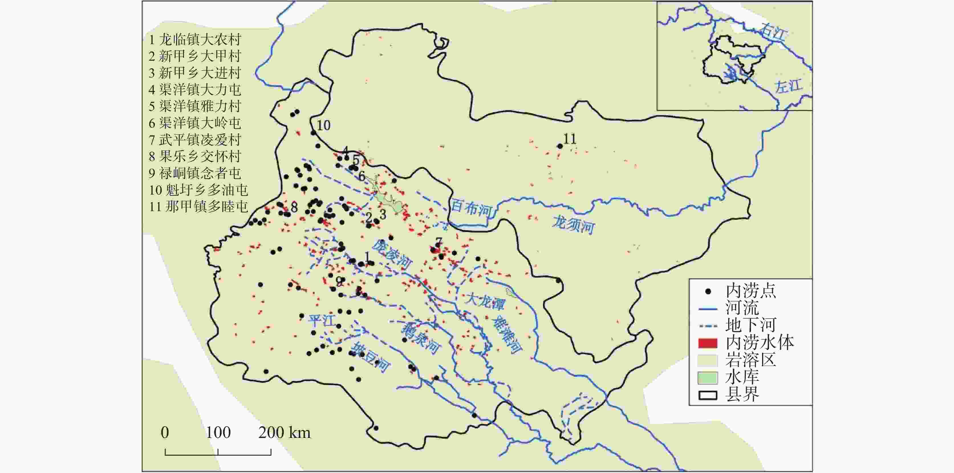
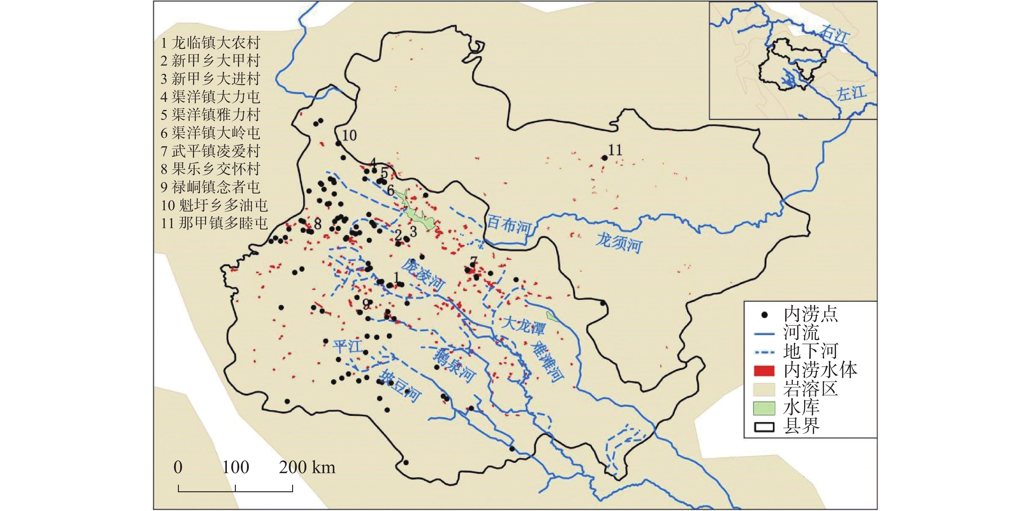
图 1 位于百色内涝中心区域的靖西和德保县内涝点分布
注:影像来源为Harmonized Landsat Sentinel-2 (DSWx-HLS)(2025年10月29日),水体解译方法参考文献[11]。岩溶分布数据来源于WOKAM[12]。图中标注了本次重点调查的11处内涝点。最大的内涝片区是凌爱村,水面面积达到105.8 hm2。
Figure 1. Distribution of waterlogging sites in Jingxi and Debao Counties, located within the central waterlogging-prone area of Baise City
Note: The imagery was derived from Harmonized Landsat Sentinel-2 (DSWx-HLS) dated Oct. 29, 2025. The water body extration method follows reference [11]. Karst distribution data were obtained from WOKAM[12]. Eleven key waterlogging sites investigated in this study are marked in the figure. The largest inundated area is Ling'ai Village, covering a water surface area of 105.8 hectares.
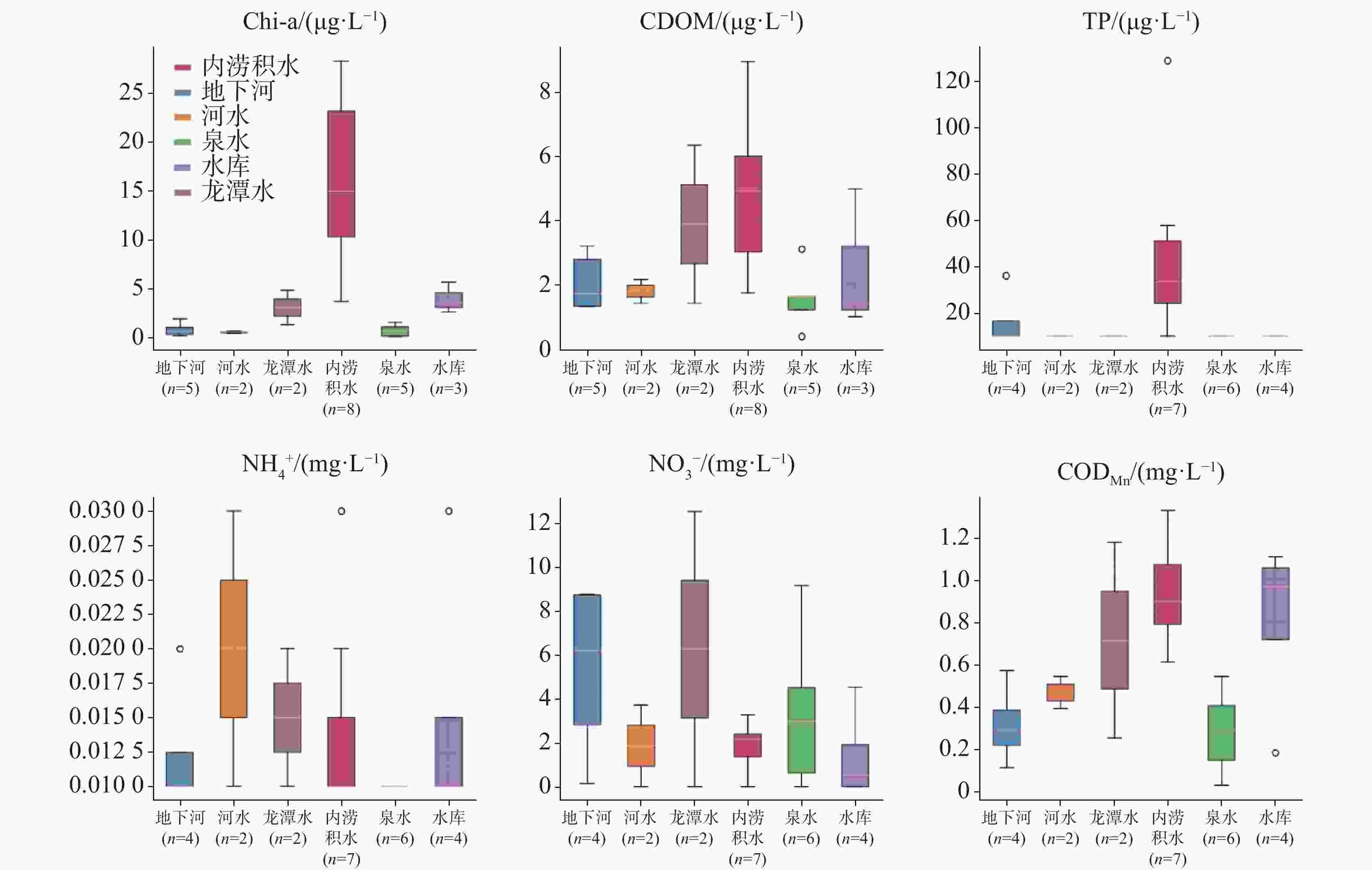
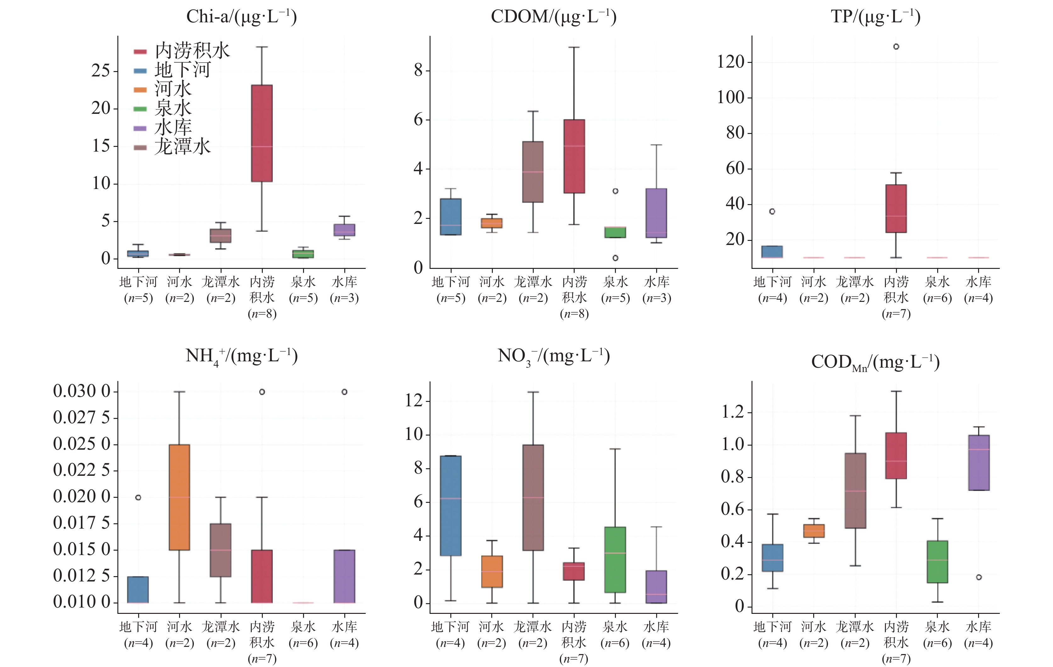
图 2 内涝积水等水体类型的Chl-a、CDOM、TP、NH$_4^{+}$、NO3、CODMn水质指标对比
Figure 2. Comparison of water quality parameters(chlorophyll, CDOM, TP, NH$_4^{+}$, NO3, and CODMn) among different water body types, including waterlogging-induced water body
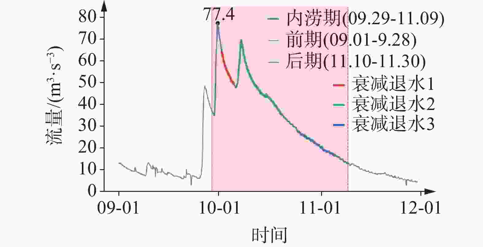
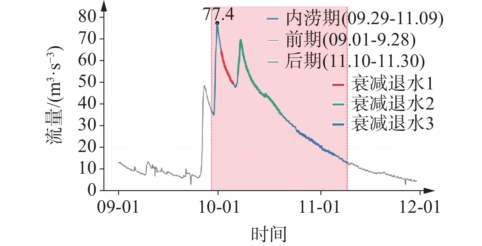
图 3 庞凌河2025年内涝期间的洪水过程曲线
注:洪水衰减三个阶段的退水系数分别为0.07 d−1、0.04 d−1、0.04 d−1。
Figure 3. Hydrograph of the Pangling River during the 2025 waterlogging event
Note: The recession coefficients for the three-phase of flood recession are 0.07 d−1, 0.04 d−1, and 0.04 d−1, respectively.
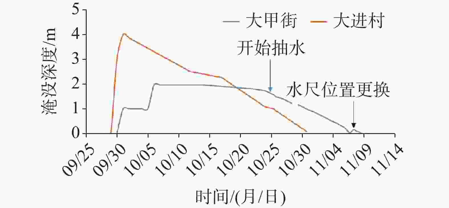
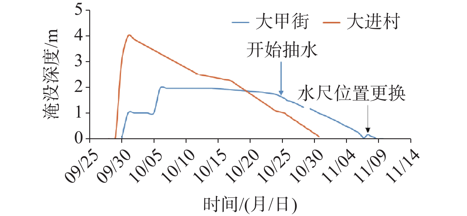
图 4 靖西市两处内涝洼地淹没深度变化曲线
注:两处洼地仅有一山之隔,但水位变化趋势不同,显示分属两个岩溶管道系统。
Figure 4. Hydrographs of two waterlogging depressions in Jingxi City
Note: Although separated only by a single hill, the two depressions exhibit divergent water-level variation trends, indicating their affiliation with distinct karst conduit systems.

图 5 大甲街抽水排涝作业布置图
注:大甲街抽排水工程是将大甲洼地的积水转移至孟球洼地,再由孟球洼地转移至1号消水洞。孟球洼地与1号落水洞之间的砂岩形成地下分水岭,是抽排水取得良好效果的原因。同时这种大流量、长距离、高扬程的排涝作业在岩溶地区获得实战经验。
Figure 5. Layout of pumping operations for waterlogging drainage at Dajiajie street
Note: The Dajiajie Street drainage and pumping project involved transferring impounded water from the Dajia Depression to the Mengqiu Depression, and subsequently into the sinkhole No. 1 . A sandstone formation between the Mengqiu Depression and sinkhole No. 1 acts as an underground watershed, which accounts for the operational success. Furthermore, this large-discharge, long-distance, and high-lift pumping operation has yielded valuable practical experience for waterlogging mitigation in karst regions.
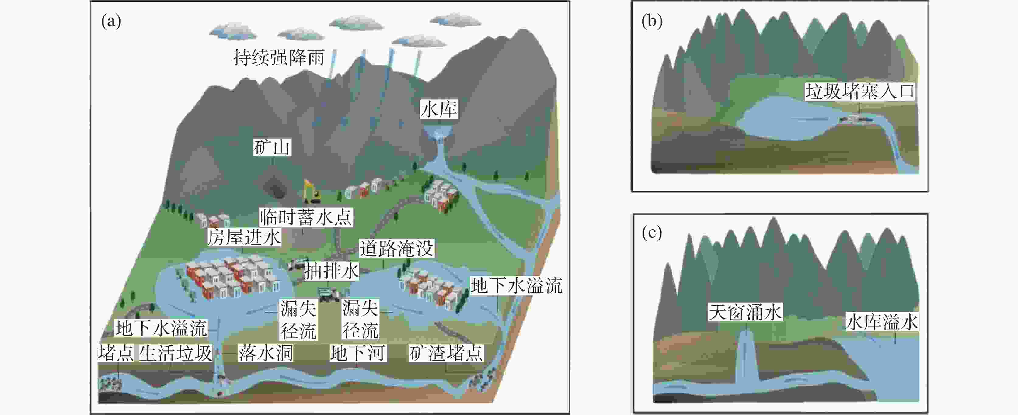
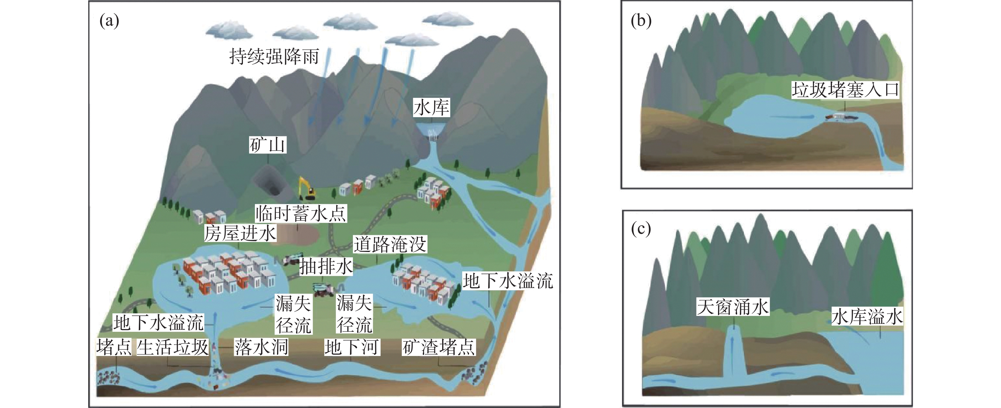
图 6 地下河系统管理概念图
注:(a)地下河中游需管理生活垃圾和矿渣避免岩溶管道堵塞;(b)上游疏通落水洞保持排水畅通;(c)下游水库及时泄洪避免顶托和倒灌。地下河系统管理需要上、中、下游协同、相邻流域配合,以及地表和地下兼顾,充分体现岩溶环境的立体结构特征。
Figure 6. Conceptual framwork for the subterranean river system management
Note: (a) In the middle reaches, domestic waste and mining slag must be regulated to prevent clogging of karst conduits; (b) In the upper reaches, sinkholes require regular unblocking to maintain unimpeded drainage; (c) In the lower reaches, timely regulated release from reserviors is essential to avoid backward effects and flow reversal(reflux). Effective management of the subterranean river system necessitates coordinated action across the upper, middle, and lower reaches, inter-basin collaboration among adjacent watersheds, and integrated control of both surface and subsurface hydrological processes. This approcah fully reflects the three-dimensional structural complexity inherent to karst environments.
表 1 百色内涝排水方案
Table 1. Drainage schemes for waterlogging mitigation in Baise City
案例* 洼地类型 致灾原因 排水方案 工程参数 4、5、6 地下河主管道串接连通的洼地 落水洞堵塞,季节性排水沟被
切断连通恢复和局部
抽水排水量3×10⁵ m3,水位下降2 m 1 地表溪流和岩溶管道双层径流
洼地落水洞堵塞,溢流水量增加 渠道分流 兴建约5 km排水渠 2、3 深切孤立型洼地 落水洞堵塞,溢流水量增加 分级强排水 排水量2.6×10⁶ m3,持续19 d,水位下降2 m 11 泉水和落水洞共存的补排径流型洼地 上游水库渗漏导致泉水流量
剧增分级强排水 排水量2.1×10⁶ m3,持续21 d,水位下降4 m 注:*案例数字与图1洼地编号对应。
Note: *Case numbers correspond to the depression labels in Fig. 1. 下载: 导出CSV
表 2 地下河水文级联响应模式
Table 2. Cascading hydrological response pattern of karst subterranean rivers
案例* 水文级联响应模式 岩溶洞穴–管道结构 人为因素 4、5、6 下游落水洞堵塞推高上游水位 明暗相间的地下河单一主管道 上游丢弃垃圾堵塞下游落水洞 10 阻止落水洞溢流导致内涝积水排水不畅 落水洞与主管道连接形成消溢水洞 填埋落水洞 1 下游堵塞造成上游溢洪洞常年溢流 具有地表明流和地下管道双层排水通道 开矿等引起的水土流失堵塞地下河 11 上游水库渗漏导致下游进入落水洞流量暴增 岩溶管道发育多条支流具有网络状结构 修建水库使支流管道排水量增加 下游大坝抬高水位引起上游洼地排水缓慢 地下河下游岩溶管道水平发育且坡度平缓 修建水库抬高水位 注:*编号数字与图1上的典型内涝点对应。
Note:* Numbers correspond to the typical waterlogging sites labeled in Fig. 1.
下载: 导出CSV
-
[1] Milanović S, Vasić L, Vakanjac V R, Milovanović B, Dašić T. Defining the functioning of developed karst systems through extreme climatic event analysis, application to the Krupaja Spring, Serbia[J]. Hydrogeology Journal, 2024, 32(8): 2011-2030. doi: 10.1007/s10040-024-02851-6 [2] 中国新闻网. 广西百色122处内涝点尚未消退 制定“一点一策”治理方案[EB/OL]. (2025-10-19)[2025-11-29]. https://www.chinanews.com.cn/sh/2025/10-19/10501018.shtml.China News Service. Guangxi Baise 122 waterlogging points have not yet receded, formulating "One Point One Policy" governance plan[EB/OL]. (2025-10-19)[2025-11-29].https://www.chinanews.com.cn/sh/2025/10-19/10501018.shtml. [3] 刘金荣, 李传玲. 岩溶地区的大化、岩滩水库与内涝灾害[J]. 广西地质, 1994(4): 39-46,52.Liu Jinrong, Li Chuanling. Dahua and Yantan Reservoirs and waterlogging disasters in karst area[J]. Guangxi Geology, 1994(4): 39-46,52. [4] Xanke J, Stevanović Z, Liesch T, Kaltenbrunn A, Ravbar N, Jourde H, Andreo B, Barberá JA, Goldscheider N. Flooding and flood water storage in karst systems of the Mediterranean region[J]. Hydrogeology Journal, 2024, 32(6): 1587-1605. doi: 10.1007/s10040-024-02811-0 [5] 张美良. 岩滩板文地下河及岩溶浸没内涝分析[J]. 广西地质, 1996(4): 54-61,67.Zhang Meiliang. Analysis of Yantan Banwen underground river and karst immersion waterlogging[J]. Guangxi Geology, 1996(4): 54-61,67. [6] 李文兴, 郭纯青. 岩滩电站库区板文地下河系岩溶侵没内涝物理模拟[J]. 广西水利水电, 1996(3): 32-38. doi: 10.16014/j.cnki.1003-1510.1996.03.008Li Wenxing, Guo Chunqing. Physical simulation of karst immersion waterlogging in Banwen underground river system of Yantan hydropower station reservoir area[J]. Guangxi Water Resources & Hydropower Engineering, 1996(3): 32-38. doi: 10.16014/j.cnki.1003-1510.1996.03.008 [7] 裴建国. 广西溶洼系统结构特征及其对岩溶内涝的影响[J]. 广西科学, 2002(3): 193-197. doi: 10.3969/j.issn.1005-9164.2002.03.011Pei Jianguo. structural characteristics of karst depression system in Guangxi and its influence on karst waterlogging[J]. Guangxi Science, 2002(3): 193-197. doi: 10.3969/j.issn.1005-9164.2002.03.011 [8] 黄奇波, 康志强, 邓忠, 唐勇臣, 吴华英, 邹昌霈, 李腾芳, 廖红为, 马俊飞, 梁建. 岩溶内涝成因机制及有效治理[J]. 中国岩溶, 2025, 44(5): 928-936. doi: 10.11932/karst20250509Huang Qibo, Kang Zhiqiang, Deng Zhong, Tang Yongchen, Wu Huaying, Zou Changpei, Li Tengfang, Liao Hongwei, Ma Junfei, Liang Jian. Genetic mechanisms and effective control of karst waterlogging[J]. Carsologica Sinica, 2025, 44(5): 928-936. doi: 10.11932/karst20250509 [9] 孙国伟. 广西忻城县北更–古蓬岩溶区排涝防洪分析[J]. 低碳世界, 2017(7): 79-80. doi: 10.3969/j.issn.2095-2066.2017.07.048Sun Guowei. analysis on flood drain and control in Beigeng-Gupeng karst area in Xincheng, Guangxi[J]. Low Carbon World, 2017(7): 79-80. doi: 10.3969/j.issn.2095-2066.2017.07.048 [10] 李庆松, 李兆林, 裴建国, 覃小群, 易连兴, 梁茂珍. 马山东部岩溶洼地谷地内涝特征与治理规划[J]. 中国岩溶, 2008, 27(4): 359-365. doi: 10.3969/j.issn.1001-4810.2008.04.011Li Qingsong, Li Zhaolin, Pei Jianguo, Qin Xiaoqun, Yi Lianxing, Liang Maozhen. Waterlogging characteristics and management planning of karst depression valley in eastern Mashan[J]. Carsologica Sinica, 2008, 27(4): 359-365. doi: 10.3969/j.issn.1001-4810.2008.04.011 [11] Jet Propulsion Laboratory, California Institute of Technology. OPERA level 3 dynamic surface water extent from harmonized Landsat-8 and Sentinel-2A/B product specification: JPL D-107395, Rev B, Version 1.0. 1[R]. Pasadena, Calif.: NASA, 2024. [12] Chen Z, Goldscheider N, Auler A S, Bakalowicz M, Broda S, Drew D, Hartmann J, Jiang G, Moosdorf N, Richts A, Stevanovic Z, Veni G, Dumont A, Aureli A, Clos P, Krombholz M. World karst aquifer map (WHYMAP-WOKAM)[M]. Berlin: BGR; Reading: IAH; Karlsruhe: KIT; Paris: UNESCO, 2017. [13] Naughton O, Johnston P M, Gill L W. Groundwater flooding in irish karst: the hydrological characterisation of ephemeral lakes (turloughs)[J]. Journal of Hydrology, 2012, 470-471: 82-97. [14] Lolcama J L, Cohen H A, Tonkin M J. Deep karst conduits, flooding, and sinkholes: Lessons for the aggregates industry[J]. Engineering Geology, 2002, 65(2-3): 151-157. doi: 10.1016/S0013-7952(01)00122-3 [15] Abolins M, Ogden A. Sinkhole flooding above a shallow bedrock aquitard in an urbanizing community, central Tennessee, USA[J]. Geomorphology, 2023, 425: 108586. doi: 10.1016/j.geomorph.2023.108586 [16] Ljubenkov I. Floods in Dinaric Karst Fields: A case study of the Dicmanjsko-Bisko Polje (Croatia)[J]. International Journal of River Basin Management, 2025, 23(2): 211-222. doi: 10.1080/15715124.2023.2277771 [17] 黄靖宇, 李春宇, 许模, 魏啟杨. 自然与工程扰动叠加影响下的滇东南岩溶大泉水文过程[J]. 中国岩溶, 2025, 44(6): 1134-1143.Huang Jingyu, Li Chunyu, Xu Mo, Wei Qiyang. Hydrological processes of large karst spring in southeast Yunnan under the superimposed influence of natural and engineering disturban-ces[J]. Carsologica Sinica, 2025, 44(6): 1134-1143. -


 点击查看大图
计量
- 文章访问数: 21
- HTML浏览量: 7
- PDF下载量: 6
- 被引次数: 0
