


Application of comprehensive detection techniques in leakage analysis of karst reservoirs
-
摘要: 通过区域岩溶水文地质调查、地球物理探测和地质钻探对太平水库库尾岩溶渗漏进行探测,对太平水库渗漏原因和渗漏特征提出新认识:水库区域范围宝塔组(O2b)灰岩地层中发育一条NE-SW向横穿太平水库的地下河,在距离水库3.2 km的老龙洞出口排泄。左右岸落水洞发生塌陷后,库水通过岩溶管道快速渗漏至地下河,是导致库水位急剧下降的原因。地球物理探测结果显示库尾左右岸均有明显异常区域,且从左岸至右岸异常区域的高程逐渐降低, 符合地下河岩溶发育一般特征。结合钻孔验证结果认为, 太平水库库尾地下河发育高程为
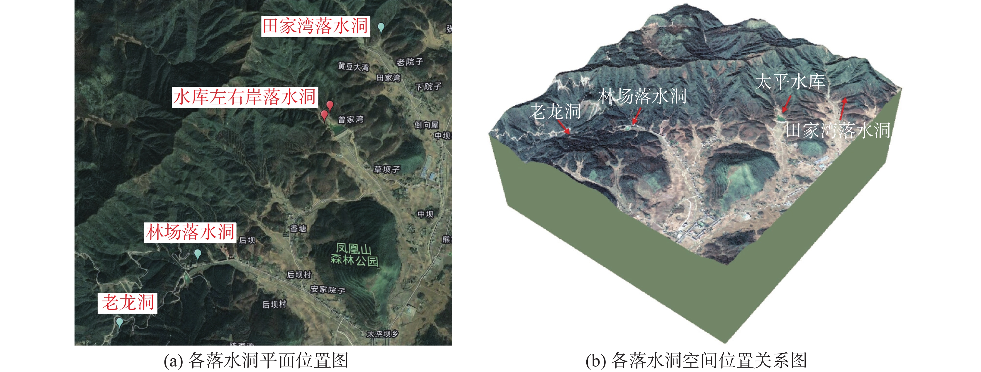
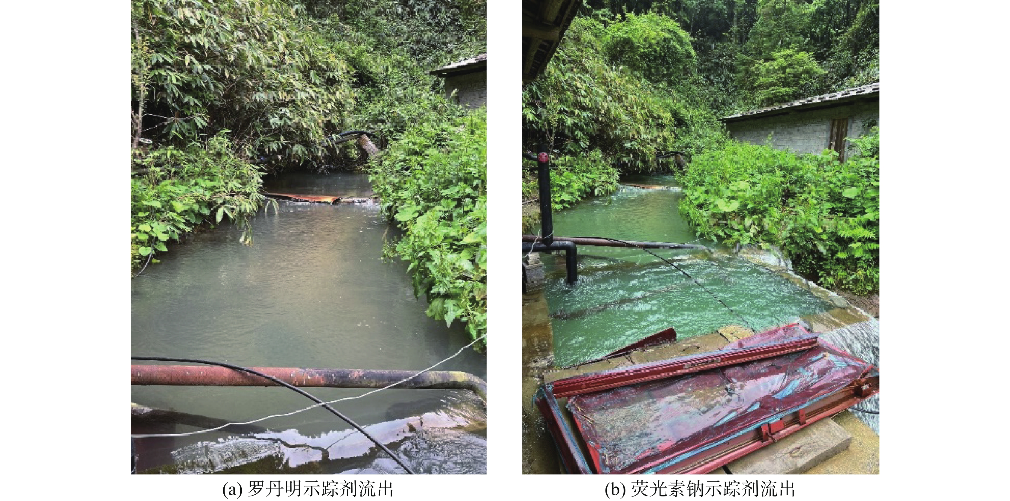
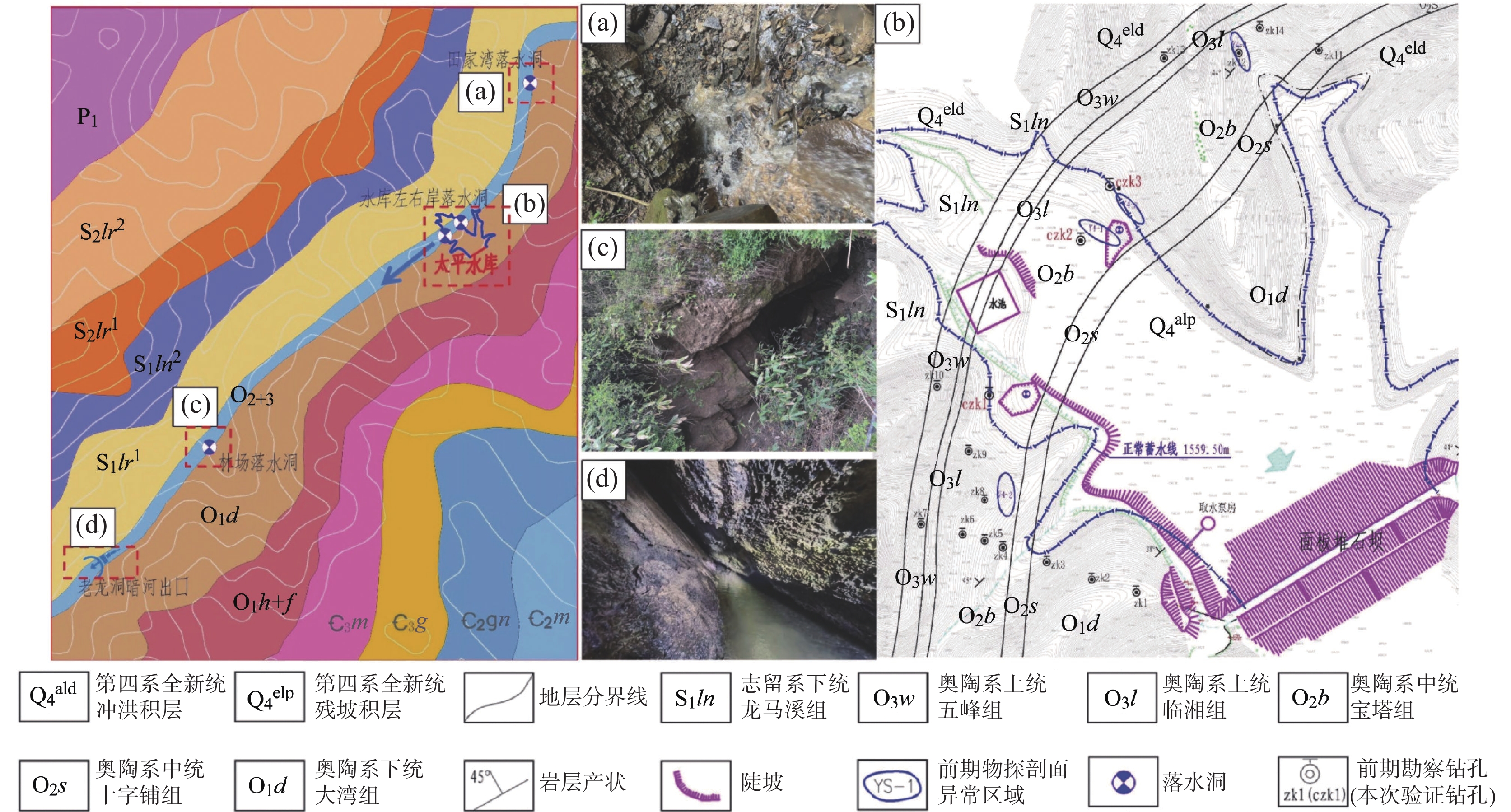
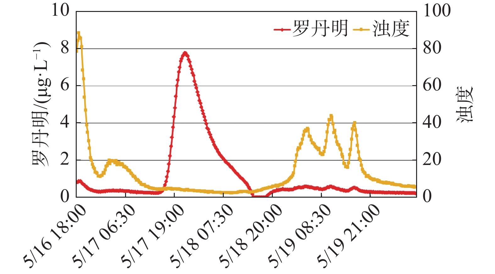
1516.36 (左岸)~1513.36 m(右岸)。研究成果可为太平水库后续防渗工作提供指导,并对岩溶地区类似水库的渗漏探测工作提供借鉴。Abstract:The reservoir is located in Fengdu county, Chongqing Municipality. After impoundment, karst collapses occurred successively on both the left and right banks at the reservoir tail. Reservoir water rapidly leaked through sinkholes within the collapse pits, causing a sharp decline in the water level and severely impacting normal functioning of the reservoir. To identify the cause and characteristics of the leakage, this study employed a combination of regional karst hydrogeological surveys, geophysical exploration, and geological drilling techniques to systematically investigate the leakage problem at the reservoir tail. The following new insights were obtained: (1) Regional karst hydrogeological surveys indicate the presence of a NE–SW trending limestone belt of the middle Ordovician Baota formation (O2b) traversing the reservoir tail. Karst development is highly pronounced within this layer, commonly featuring solution fissures, caves, and conduits. Field surveys identified multiple sinkholes distributed in a bead-like pattern along the strike of this limestone formation. Tracer tests confirmed the existence of an underground river flowing through the reservoir in a NE–SW direction, with its outlet at Laolong cave, located 3.2 km southwest of the reservoir. The longitudinal gradient of this underground river system is steep, with a vertical drop of approximately 130 m. The development of various karst features at the reservoir tail and the direction of groundwater flow are both influenced by this underground river system. Reservoir impoundment induced the collapses of sinkholes on both banks, allowing reservoir water to directly access into the underground river and discharge at Laolong cave. This has been identified as the fundamental cause of the sudden drop in the reservoir water level. (2) Controlled Source Audio-Frequency Magnetotellurics (CSAMT) and the High-Density Resistivity (HDR) method were selected as geophysical exploration techniques to characterize the spatial distribution of the underground river. These two methods complemented and mutually validated each other's findings. Three CSAMT survey lines were deployed. The results revealed a relatively enclosed low-resistivity zone extending from the left bank to the right bank, with elevations ranging from 1,510 m to 1,500 m, showing a gradual decrease in elevation from left to right. Additionally, three HDR survey lines were conducted. The results indicated underground river elevations of approximately 1,530 m at the low adjacent valley on the left bank, approximately 1,515 m at the left bank of the reservoir, and approximately 1,500 m at survey line yd-4 on the right bank mountain. The gradient of the karst conduit within the reservoir area is inferred to be 1.5% to 2.0%. The alignment of anomalous zones identified by both methods generally follows a NE–SW direction, consistent with the bedrock strike. Furthermore, the elevation of these anomalous zones gradually decreases from the left bank to the right bank, further confirming that the underground river primarily develops along the bedrock strike, flowing from NE to SW. (3) Geological boreholes were drilled based on geophysical anomalies. These boreholes revealed significant vertical karst development within the Baota formation limestone at the reservoir tail. Borehole CZK1 intersected a karst cave; the elevated position of this conduit and its proximity to a sinkhole on the right bank suggest that it is a branch conduit connecting the right bank sinkhole to the underground river. Borehole CZK3 encountered a cavity nearly three-meter high, located near the bottom of the Baota formation limestone at elevations between 1,519.26 m and 1,516.36 m. Water level monitoring in the boreholes indicated shallow water levels within the conduits and significant silt accumulation, supporting the interpretation that this feature represents the underground river karst conduit. (4) Based on integrated geophysical exploration and geological drilling, the elevation of the karst conduit floor of the underground river in the reservoir area ranges from 1,516.36 m on the left bank to 1,513.36 m on the right bank. The estimated conduit dimensions are approximately 2.7 m in width and 2.9 m in height. Near the reservoir head and surrounding areas, the Shizipu formation (O2s) serves as a relatively impermeable layer. On the left bank, the underground river conduit near the reservoir tail passes through the Baota Formation limestone, where the burial depth of the relatively impermeable layer increases closer to the tail. Weakly karstified rock masses on this side act as the lower impermeability boundary. The recommended anti-seepage floor elevation for the left bank is approximately 1,516.0 m. (5) During the investigation phase of karst reservoirs, comprehensive regional karst hydrogeological surveys must be conducted to accurately characterize groundwater flow paths. Only through this approach can the impoundment conditions of the reservoir be clearly understood. In reservoir leakage investigations, relying solely on a single geophysical method or a single borehole to identify leakage pathways and directions is suggested be avoided. This study has elucidated the causes, pathways, and key channel characteristics of leakage at the reservoir. The findings provide a direct foundation for the subsequent design of anti-seepage engineering measures for this reservoir and offer valuable reference for the detection and prevention of similar leakage issues in reservoirs located in karst regions. -
Key words:
- Taiping reservoir /
- karst leakage /
- underground water /
- hydrogeology /
- geophysical detection /
- geological drilling
-
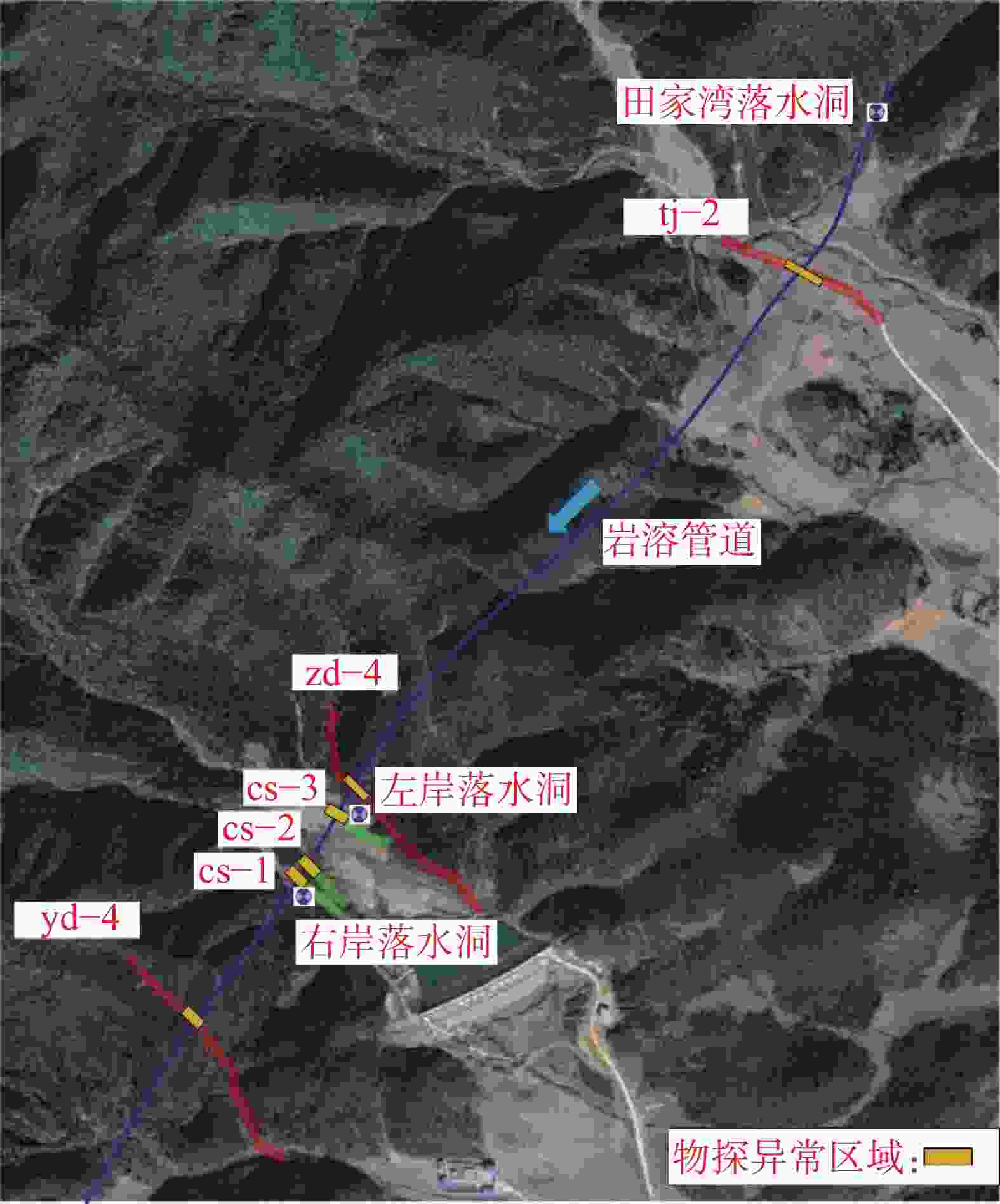
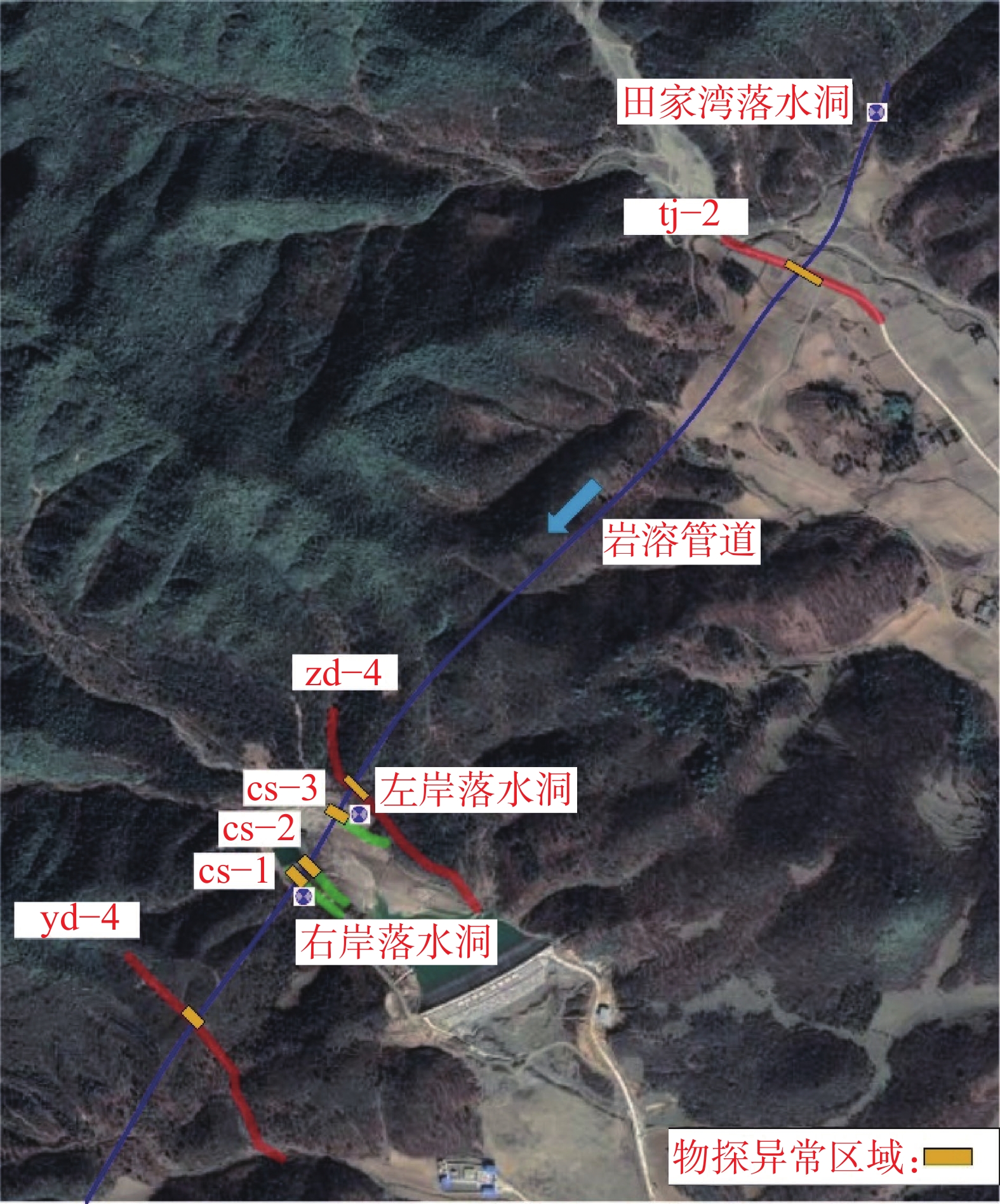
图 9 物探线布置与岩溶发育的平面分布图
Figure 9. Plan layout of geophysical prospecting lines and karst development
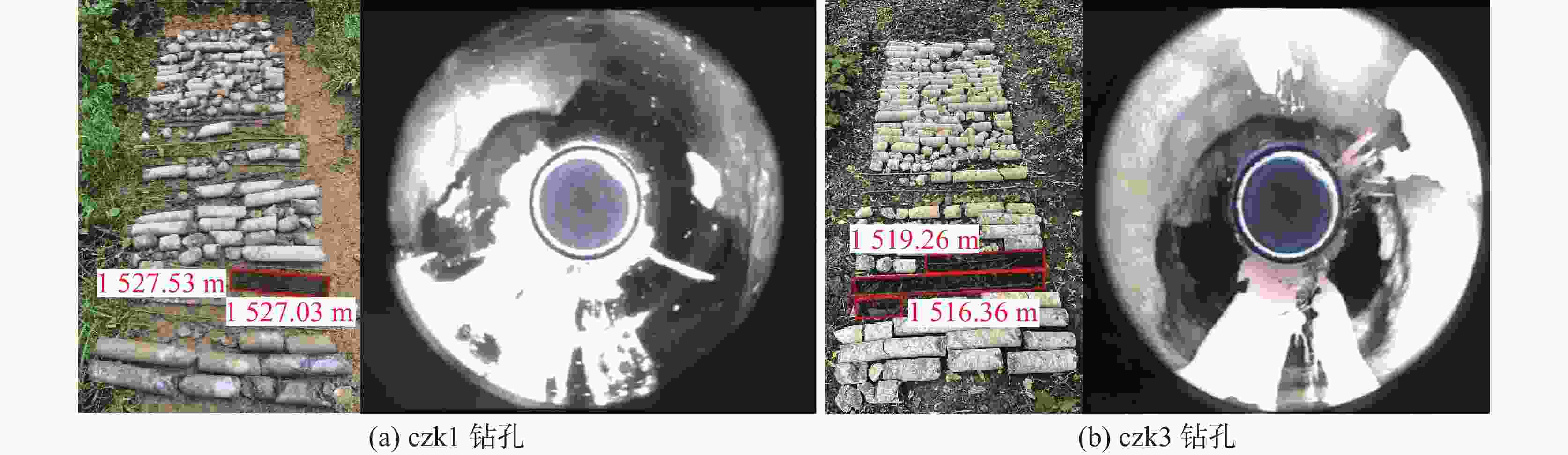
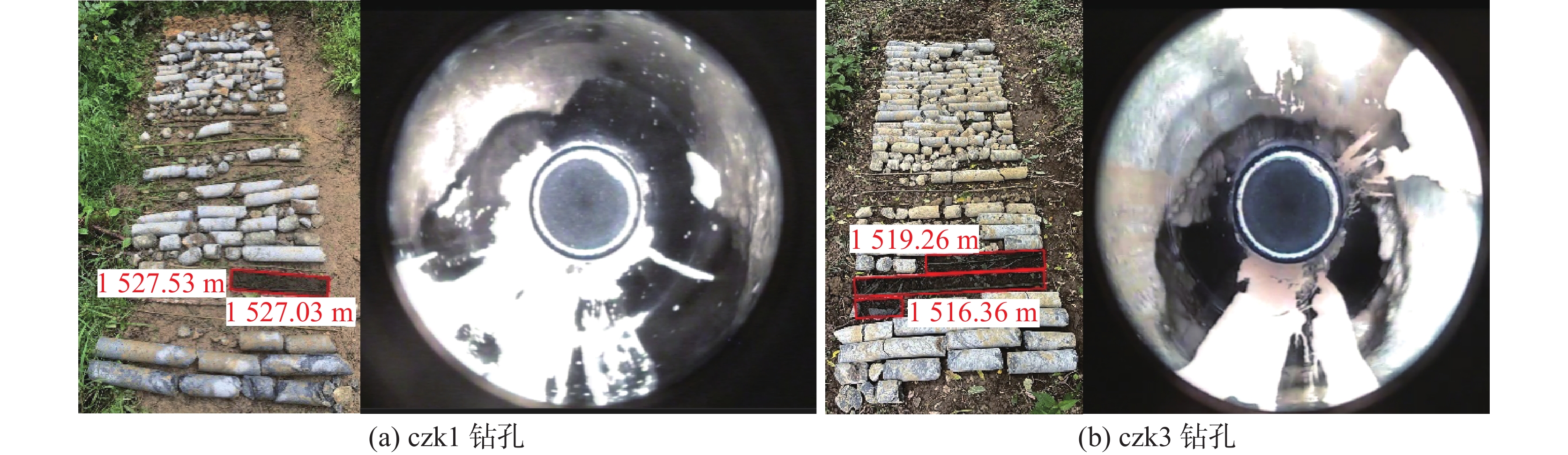
图 10 钻孔岩芯及岩溶管道钻孔电视图
Figure 10. TV Images of drilled cores and boreholes in karst conduits
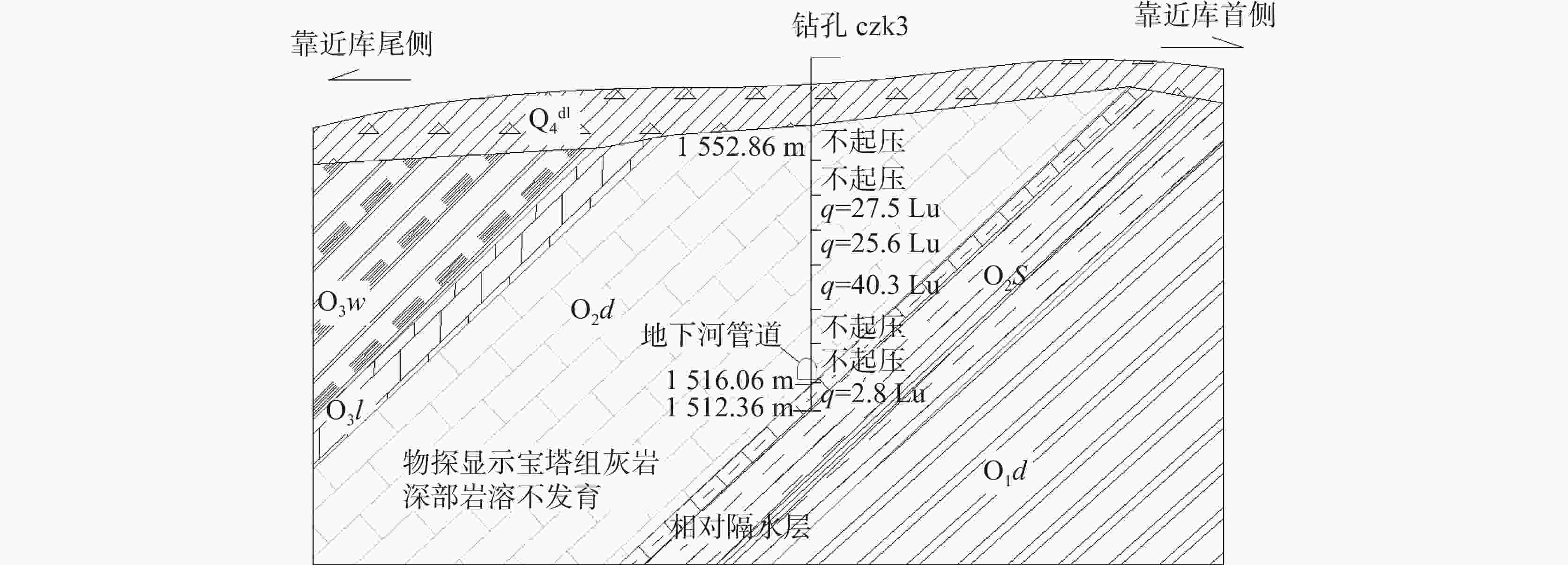
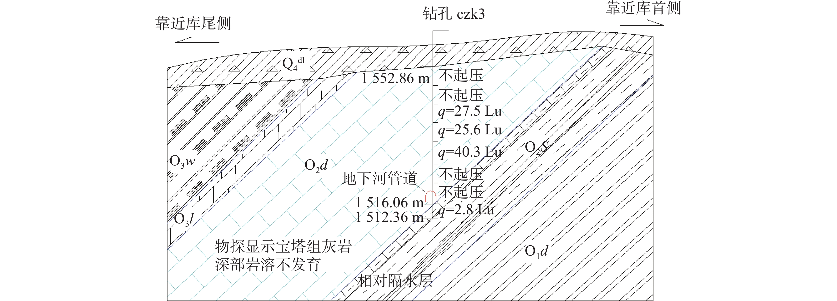
图 11 地下河在左岸地层中的位置分布示意图
Figure 11. Schematic diagram of underground river distribution within the left bank- strata
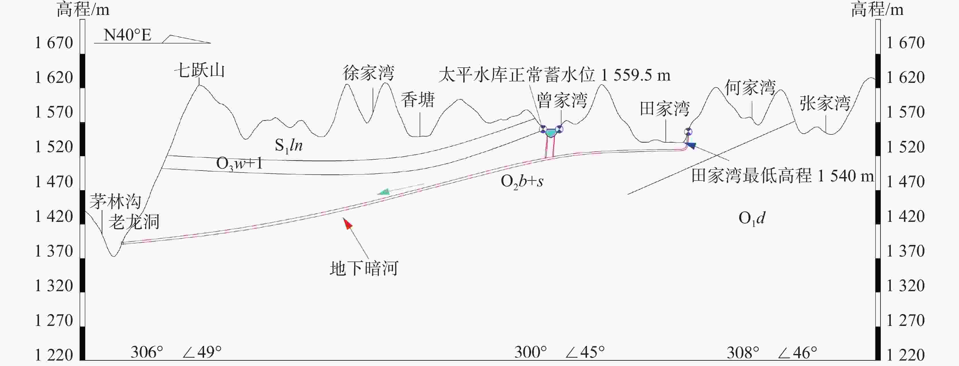
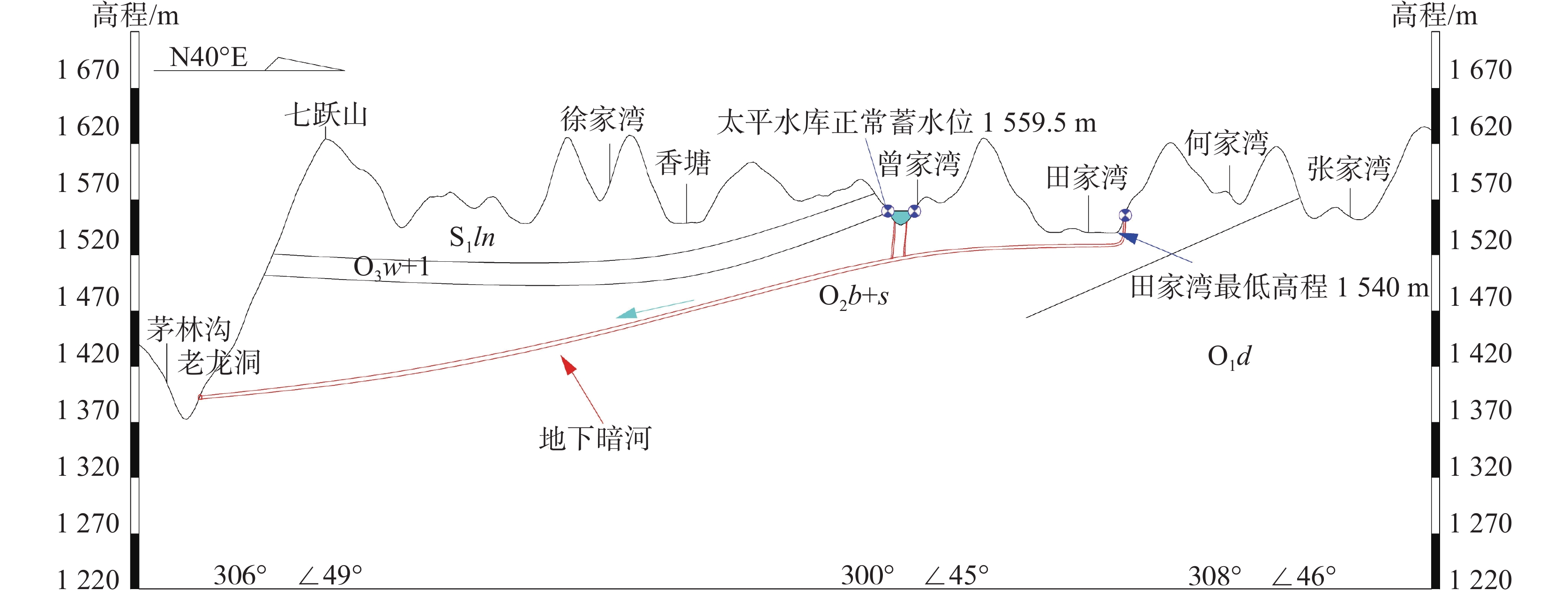
图 12 太平水库区域地下河发育情况
Figure 12. Development of underground rivers in the Taiping reservoir area
表 1 水库库区出露地层岩性表
Table 1. Lithology of the reservoir area
系 统 组 地层代号 地层厚度/m 岩 性 简 述 第四系 Q 0~20.0 冲洪积层,主要为红褐色、黄褐色粉质黏土夹碎石;残坡积层为灰黄色粉质黏土夹全风化页岩 志留系 下统 龙马溪组 S1ln 486.0~613.0 上段为灰绿、黄绿色泥质胶结的粉砂岩、粉砂质页岩及页岩,下段黄绿色粉砂质页岩及页岩;主要分布于库尾 奥陶系 上统 五峰组 O3w 11.6~12.8 灰褐色页岩,黑色炭质页岩,含碳量高,手摸染手,在陈家湾冲沟处出露 临湘组 O3l 4.2~6.1 灰至深灰色泥灰岩,纹理状构造,局部含白云质;主要分布在库尾 中统 宝塔组 O2b 28.8~40.1 灰白色、灰色裂纹状、龟裂纹灰岩,分布在库尾 十字铺组 O2s 10.0~20.4 灰至深灰色泥质灰岩,钙质泥岩,局部夹灰黄色粉砂质页岩,分布在库尾 下统 大湾组 O1d3 O1d3-3 3.5~16.3 黄褐色页岩,薄层状构造,分布于库首 O1d3-2 14.8 深灰色页岩,含钙质胶结,局部含生物化石 O1d3-1 20.0 灰黄色、灰绿色薄层状页岩,薄层状构造,夹深褐色生物碎屑薄层 O1d2 19.2 灰白色灰岩,厚层构造 O1d1 87.0 上部黄绿色页岩,中部深灰色泥质生物灰岩,下部灰岩页岩互层,分布于库首  下载: 导出CSV
表 2 示踪剂投放信息表
Table 2. Information on the tracer delivery
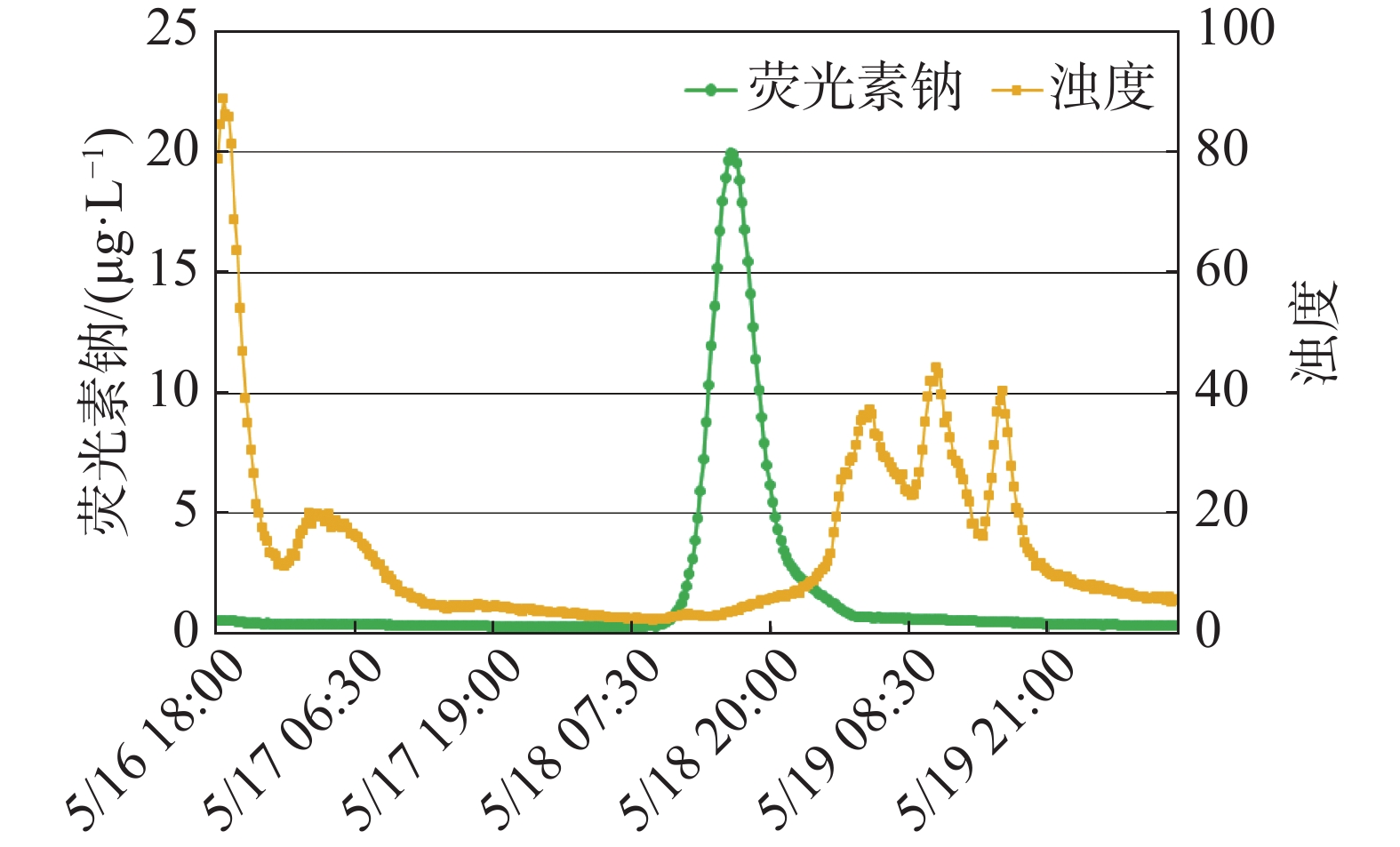
示踪剂 投放位置 投放点高程/m 运移距离/m 投放量/g 荧光素钠 田家湾
落水洞1554.79 4360 300 罗丹明 水库左岸
落水洞1548.80 3370 310
下载: 导出CSV
表 3 地球物理探测测线布设参数
Table 3. Layout parameters for geophysical detection lines
探测技术 测线名称 布置位置 测线长/m 探测
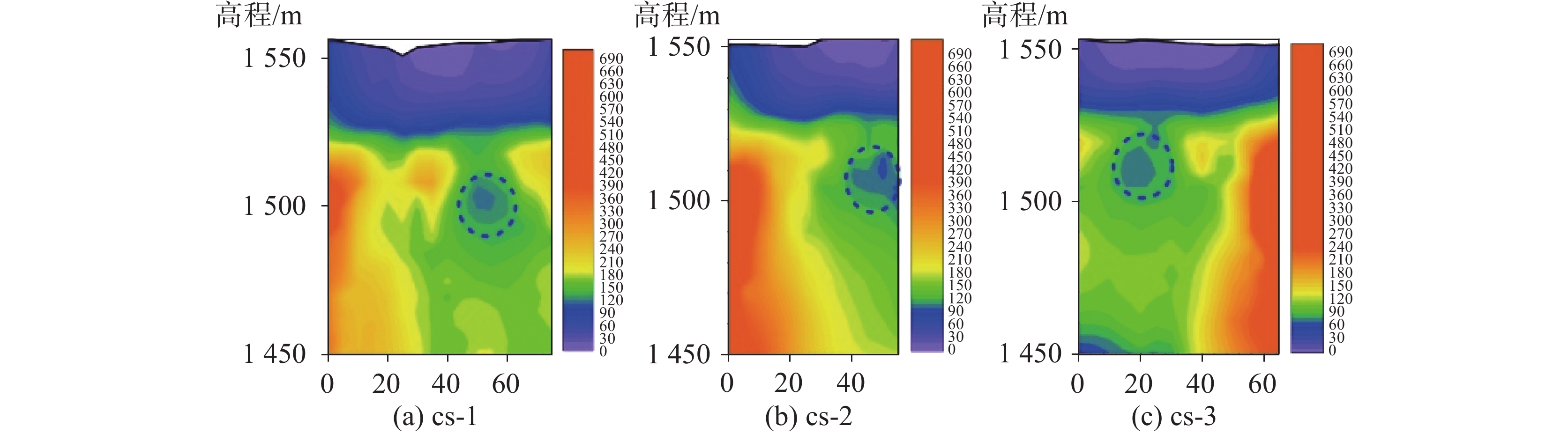
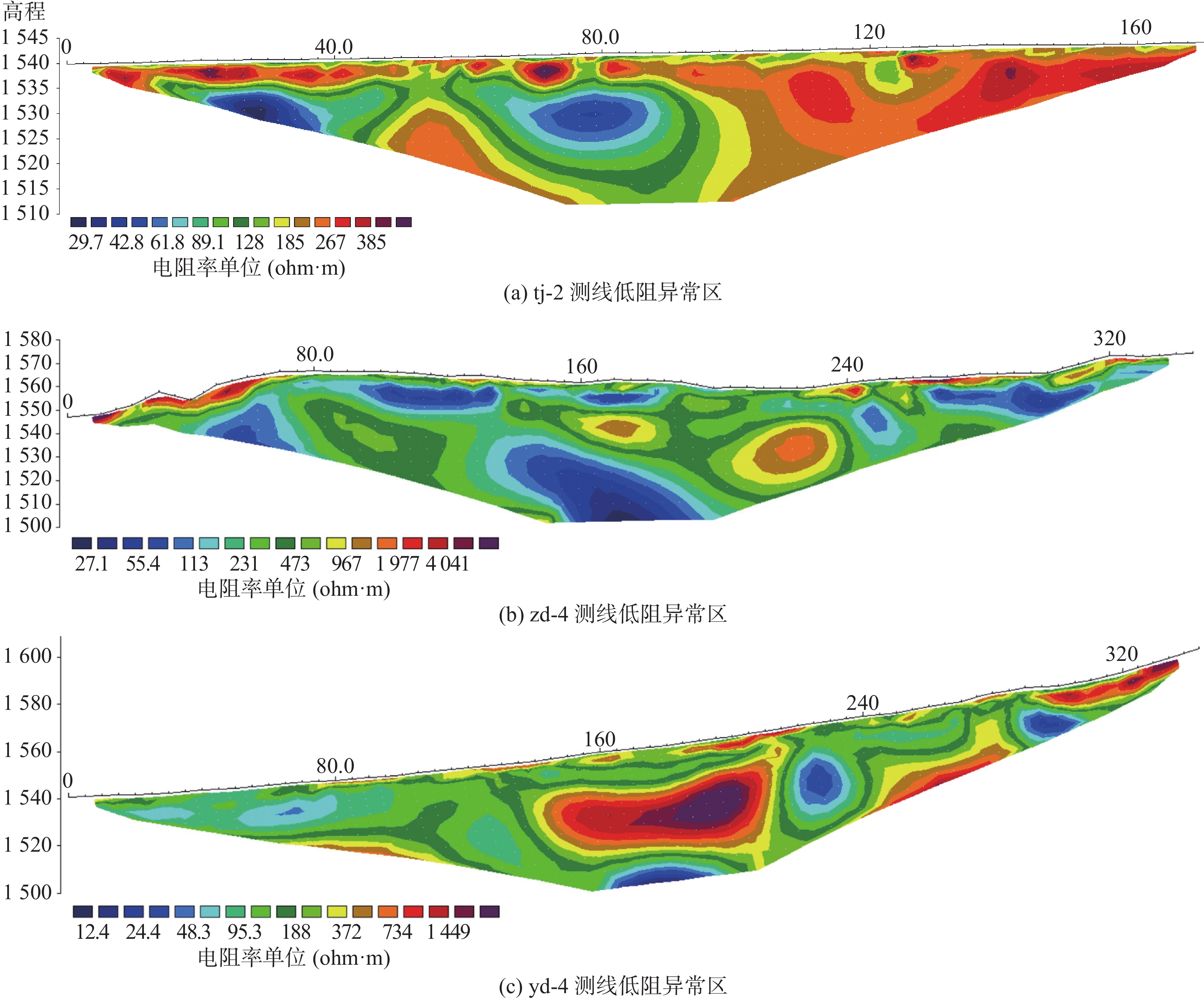
方向可控源音频大地电磁法 cs-1 河床右岸 75.0 库首至库尾 cs-2 河床中间 55.0 库首至库尾 cs-3 河床左岸 65.0 库尾至库首 高密度电法 tj-2 左侧田家湾 172.5 库首至库尾 zd-4 库尾左岸 345.0 yd-4 右岸 345.0
下载: 导出CSV
表 4 钻孔揭示岩溶发育情况表
Table 4. Karst development revealed by boreholes
孔号 孔口高程/m 钻进深度/m 溶蚀发育高程/m 掉钻高程/m 钻孔漏水位置/m 地下水位/m czk1 1560.73 45.4 1544.13 ~1536.43 1531.73 ~1526.73 1538.13 ~1537.23 1527.53 ~1527.03 1543.93 1527.20 czk2 1551.87 30.7 1547.42 ~1539.62 无掉钻 全返水 1546.32 czk3 1559.66 47.3 1552.86 ~1544.96 1530.26 ~1516.36 1552.56 ~1552.06 1548.96 ~1548.66 1548.16 ~1547.86 1545.36 ~1544.96 1526.16 ~1525.96 1519.26 ~1516.36 1552.00 1516.44
下载: 导出CSV
-
[1] 薛伟, 袁宗峰, 周密. 西南地区某岩溶水库渗漏分析[J]. 中国岩溶, 2019, 38(4): 508-514.Xue Wei, Yuan Zongfeng, Zhou Mi. Analysis on leakage of a karst reservoir in southwestern China[J]. Carsologica Sinica, 2019, 38(4): 508-514. [2] 刘天云, 罗锐恒, 胡顺强, 赵永宾, 潘晓东, 刘伟. 文山小河尾水库岩溶渗漏水文地质条件与管道位置识别[J]. 中国岩溶, 2022, 41(1): 88-99.Liu Tianyun, Luo Ruiheng, Hu Shunqiang, Zhao Yongbin, Pan Xiaodong, Liu Wei. Hydrogeological conditions of karst leakage and identification of pipeline location in Xiaohewei reservoir, Wenshan[J]. Carsologica Sinica, 2022, 41(1): 88-99. [3] 王忠波, 吴波, 李勇, 袁晨瀚. 贵州西南岩溶地质特征及常用勘察技术及应用[J]. 四川地质学报, 2019, 39(3): 464-467.Wang Zhongbo, Wu Bo, Li Yong, Yuan Chenhan. Geological features and common survey techniques in karst region, Southwest Guizhou[J]. Acta Geologica Sichuan, 2019, 39(3): 464-467. [4] 崔正伟, 朱正君, 丰赟, 郝名扬. 综合物探方法和检测技术在大坝渗漏检测中的应用[J]. 工程地球物理学报, 2024, 21(2): 205-214.Cui Zhengwei, Zhu Zhengjun, Feng Yun, Hao Mingyang. Application of comprehensive geophysical exploration method and detection technology in dam seepage detection[J]. Chinese Journal of Engineering Geophysics, 2024, 21(2): 205-214. [5] 张建清, 徐磊, 李鹏, 马圣敏, 肖璐笛. 综合物探技术在大坝渗漏探测中的试验研究[J]. 地球物理学进展, 2018, 33(1): 432-440.Zhang Jianqing, Xu Lei, Li Peng, Ma Shengmin, Xiao Ludi. Experimental study on comprehensive geophysical prospecting technology in dam leakage detection[J]. Progress in Geophysics, 2018, 33(1): 432-440. [6] 邹晓磊, 杨宏智, 郭聪. 水库岩溶渗漏通道探测技术与应用[J]. 农业工程, 2021, 11(5): 98-102.Zou Xiaolei, Yang Hongzhi, Guo Cong. Detection technology and application of reservoir karst seepage path[J]. Agricultural Engineering, 2021, 11(5): 98-102. [7] 周建兵, 罗锐恒, 贺昌坤, 潘晓东, 张绍敏, 彭聪. 文山小河尾水库岩溶含水渗漏通道的地球物理新证据[J]. 物探与化探, 2023, 47(3): 707-717.Zhou Jianbing, Luo Ruiheng, He Changkun, Pan Xiaodong, Zhang Shaomin, Peng Cong. New geophysical evidence for karst water-bearing seepage pathways in the Xiaohewei reservoir, Wenshan City[J]. Geophysical and Geochemical Exploration, 2023, 47(3): 707-717. [8] 肖伟, 邹德兵, 闫福根, 蔡汉生. 龙塘水库库坝区岩溶渗漏分析及渗控设计[J]. 水利水电技术, 2024, 55(S2): 196-202.Xiao Wei, Zou Debing, Yang Fugen, Cai Hansheng. Karst leakage analysis and seepage control design of Longtang Reservoir and dam[J]. Water Resources and Hydropower Engineering, 2024, 55(S2): 196-202. [9] 曾洁, 潘晓东, 任坤, 刘伟, 彭聪, 郑智杰. 贵州省碧云湖岩溶渗漏水文地质条件与渗漏管道位置识别[J]. 中国岩溶, 2024, 43(1): 201-208.Zeng Jie, Pan Xiaodong, Ren Kun, Liu Wei, Peng Cong, Zheng Zhijie. Hydrogeological conditions of karst leakage and locating of leakage channels in Biyun lake, Guizhou[J]. Carsologica Sinica, 2024, 43(1): 201-208. [10] 刘胜, 郑克勋, 王森林. 连通试验在山区沟谷岩溶水库渗漏勘察中的应用[J]. 水利与建筑工程学报, 2022, 20(1): 108-113.Liu Sheng, Zheng Kexun, Wang Senlin. Application of connectivity test in leakage investigation of karst reservoir in mountain valley[J]. Journal of Water Resources and Architectural Engineering, 2022, 20(1): 108-113. [11] 曾荣福, 郑克勋, 王钦权. 岩溶水库渗透破坏型渗漏勘察与评价[J]. 中国岩溶, 2023, 42(1): 119-127.Zeng Rongfu, Zheng Kexun, Wang Qinquan. Investigation and evaluation of seepage failure type leakage of seepage control body of karst reservoir[J]. Carsologica Sinica, 2023, 42(1): 119-127. [12] 姚莎莎, 张毅, 王新文, 李先恒, 许江坤, 郭发贵, 蒙彦. 运用示踪试验分析隧道和岩溶泉的水力联系及介质特征: 以关山隧道为例[J]. 中国岩溶, 2024, 43(1): 25-32.Yao Shasha, Zhang Yi, Wang Xinwen, Li Xianheng, Xu Jiangkun, Guo Fagui, Meng Yan. Analysis on the hydraulic connection and medium characteristics between tunnels and karst springs by tracer tests: A case study of Guanshan tunnel[J]. Carsologica Sinica, 2024, 43(1): 25-32. [13] 罗锐恒, 刘天云, 胡顺强, 潘晓东, 刘伟. 地球物理技术在岩溶水库渗漏通道识别中的应用[J]. 人民长江, 2022, 53(7): 128-134.Luo Ruiheng, Liu Tianyun, Hu Shunqiang, Pan Xiaodong, Liu Wei. Application of geophysical technology in leakage channel identification of reservoir in karst area[J]. Yangtze River, 2022, 53(7): 128-134. [14] 郑智杰, 张伟, 曾洁, 甘伏平. 综合物探方法在碳质灰岩库区岩溶渗漏带调查中的应用研究[J]. 地球物理学进展, 2017, 32(5): 2268-2273.Zheng Zhijie, Zhang Wei, Zeng Jie, Gan Fuping. Application research of integrated geophysical methods to karst seepage investigation in carbonaceous limestone reservoir area[J]. Progress in Geophysics, 2017, 32(5): 2268-2273. [15] 陆才昆. 综合物探方法在库区渗漏通道勘探中的应用[J]. 广西水利水电, 2023(2): 22-26.Lu Caikun. Application of comprehensive geophysical prospecting method in leakage channel exploration of reservoir area[J]. Guangxi Water Resources & Hydropower Engineering, 2023(2): 22-26. [16] 韩凯, 陈玉玲, 陈贻祥, 甘伏平, 郑智杰, 张伟. 岩溶病害水库的渗漏通道探测方法: 以广西全州县洛潭水库为例[J]. 水力发电学报, 2015, 34(11): 116-125.Han Kai, Chen Yuling, Chen Yixiang, Gan Fuping, Zheng Zhijie, Zhang Wei. Detection method of leakage passages in karst disease reservoirs: A case study of Luotan reservoir in Quanzhou county of Guangxi[J]. Journal of Hydroelectric Engineering, 2015, 34(11): 116-125. [17] 彭军, 高建华, 熊友亮, 余修毕, 李欢. 综合物探在贵州胜土水库岩溶调查中的应用[J]. 勘察科学技术, 2022(1): 61-64.Peng Jun, Gao Jianhua, Xiong Youliang, Yu Xiubi, Li Huan. Application of comprehensive geophysical technique in karst investigation of Shengtu reservoir in Guizhou Province[J]. Site Investigation Science and Technology, 2022(1): 61-64. [18] 徐力群, 张国琛, 马泽锴. 土石堤坝隐患探测综合物探技术发展综述[J]. 地球物理学进展, 2022, 37(4): 1769-1779.Xu Liqun, Zhang Guochen, Ma Zekai. Development of comprehensive geophysical prospecting technology for hidden danger detection of earth rock dams[J]. Progress in Geophysics, 2022, 37(4): 1769-1779. [19] 赵志豪, 王孔伟, 周准, 刘士元, 张凯元, 王岚. 张玉坑磷石膏集中库岩溶水文地质调查与示踪[J]. 中国岩溶, 2023, 42(3): 413-424.Zhao Zhihao, Wang Kongwei, Zhou Zhun, Liu Shiyuan, Zhang Kaiyuan, Wang Lan. Karst hydrogeological survey and tracing of Zhangyukeng phosphogypsum repository[J]. Carsologica Sinica, 2023, 42(3): 413-424. -

 点击查看大图
计量
- 文章访问数: 1604
- HTML浏览量: 70
- PDF下载量: 26
- 被引次数: 0
