

Cultivated land fragmentation and its influencing factors in karst mountainous areas from the perspective of geomorphic differentiation
-
摘要: 文章以毕节市七星关区为研究对象,综合分析不同地貌类型下的耕地细碎化特征及其空间关联性,同时利用多元线性回归模型和地理探测器模型测算各影响因素的作用强度。结果表明:(1)七星关区地貌可划分为低山河谷坡地、中山丘陵坝地、中山坡谷地和中山丘陵坡地4类,各地貌类型涵盖的行政村个数分别为49个、162个、81个和185个;(2)七星关区耕地细碎化程度较高,权属细碎化程度高于景观细碎化程度,且存在明显的空间分异;(3)不同地貌类型组合特征鲜明,低山河谷坡地景观细碎化高、权属细碎化低,中山坡谷地权属细碎化高、景观细碎化低,中山丘陵坝地景观与权属细碎化双高,中山丘陵坡地两者均较低;(4)景观细碎化主要受建设用地比例、高程和地形切割度的影响,其中低山河谷坡地、中山丘陵坡地与坡度呈正相关,中山坡谷地与地形切割度呈正相关,中山丘陵坝地由建设用地比例驱动;权属细碎化的关键驱动因子为建设用地比例和农村人口密度,其中低山河谷坡地、中山坡谷地及中山丘陵坡地核心驱动因子为农村人口密度,中山丘陵坝地主要与人均耕地面积呈正相关。建议基于不同地貌类型区耕地资源禀赋特点,从景观与权属双重视角下开展土地资源综合治理,以推动七星关区农业现代化发展。Abstract:
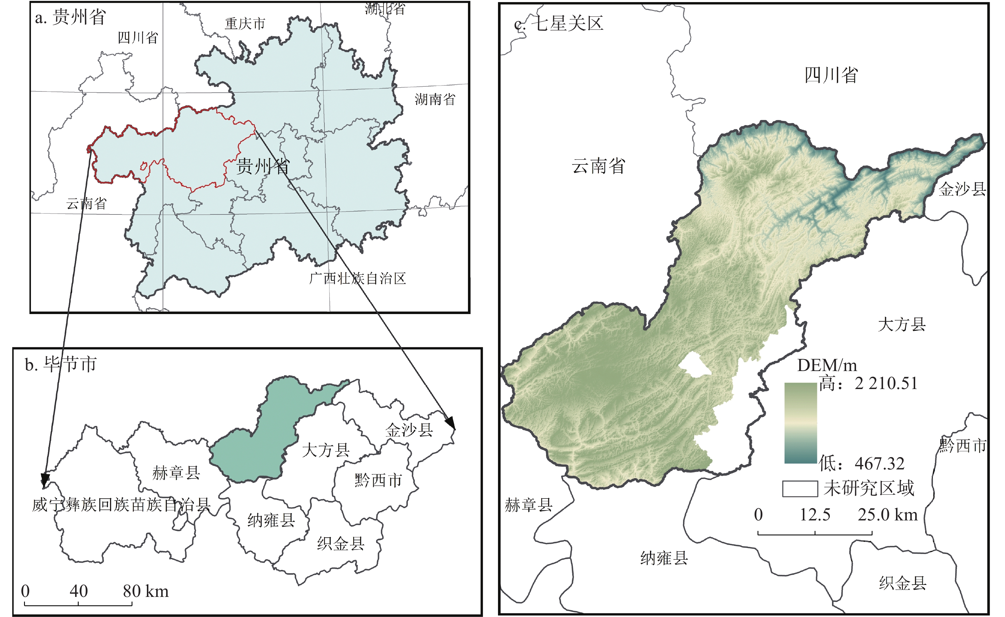
The fragmentation of cultivated land, as a land use pattern contrasting with large-scale farming operations, constrains agricultural modernisation and sustainable development. This is particularly pronounced in the karst mountainous regions of southwestern China, where factors such as the fundamental agricultural conditions of large population and limited land, the egalitrian allocation method of matching fertile and infertile plots, combining with distant and nearby plots, and the complex natural environment dominated by mountainous terrain have led to a marked pattern of cultivated land fragmentation. Consequently, targeted research holds significant importance for ensuring food security and achieving cultivated land comprehensive governance in karst mountainous areas. The Qixingguan District, situated in northwestern Guizhou Province, exhibits a topography that slopes from southwest to northeast in a terraced descent. The terrain is complex, characterised by extensive mountainous hills and limited plains or basins, with karst landforms such as peak clusters and trough valleys developed throughout. The region's geology is dominated by carbonate rocks and basalt, with pronounced rock desertification, making it a quintessential example of China's ecologically fragile karst areas in the southwest. Furthermore, the spatial distribution of cultivated land presents the characteristics of scattered, small, and fragmented, with sharp contradictions between people and land, providing an ideal case area for the study of cultivated land fragmentation. This study employs 37 townships and sub-districts, encompassing 477 administrative villages within Qixingguan District, as its research units. Drawing upon data from the Third National Land Survey, rural land contract management rights, and farm household surveys datas, it aims to systematically reveal the characteristics, patterns and spatial correlations of cultivated fragmentation across different landform types, accurately identify the key influencing factors and their respective intensities, and thereby provide a scientific basis for the comprehensive governance of cultivated land fragmentation in karst mountainous areas. The research methodology primarily comprises, (1) Delineating landform types within the study area by integrating regional topographic characteristics and relevant classification standards; (2) Constructing an evaluation index system for cultivated land fragmentation from dual perspectives of landscape and ownership to comprehensively characterise fragmentation status; (3) Employing spatial autocorrelation analysis to reveal the spatial distribution patterns and correlation characteristics of cultivated land fragmentation; (4) Utilising multiple linear regression models and geographic detector models to quantify the intensity of influence and regional variations of each factor on landscape fragmentation and ownership fragmentation. The research findings indicate, (1) The landforms of Qixingguan District can be categorised into four types: low mountain valley slopes, medium mountain hilly terraces, medium mountain valley terraces, and medium mountain hilly slopes. The number of administrative villages covered by each landform type is 49, 162, 81, and 185, respectively; (2) Qixingguan District exhibits high levels of cultivated land fragmentation, with ownership fragmentation exceeding landscape fragmentation. Distinct high-value and low-value zones are discernible. Administrative villages in medium-mountain valley slopes and medium-mountain hilly slopes demonstrate stronger cultivated land resource scale and spatial aggregation, while those in low-mountain river valley slopes and medium-mountain hilly slopes exhibit greater operational intensity; (3) The spatial distribution of cultivated land fragmentation in Qixingguan District exhibits correlations, with distinct combinations of topographic features: low mountain river valley slopes show high landscape fragmentation and low ownership fragmentation; medium mountain valley slopes exhibit high ownership fragmentation and low landscape fragmentation; medium mountain upland terraces demonstrate high levels of both landscape and ownership fragmentation; while medium mountain upland slopes display relatively low levels of both; (4) Landscape fragmentation is primarily influenced by the proportion of construction land, elevation, and terrain dissection. Specifically: low mountain river valley slopes and medium mountain hilly slopes show positive correlations with slope gradient; medium mountain slope valleys correlate positively with terrain dissection; while medium mountain hilly terraces are driven by the proportion of construction land. The key drivers of ownership fragmentation are the proportion of construction land and rural population density. Among these, rural population density is the core driver for low mountain river valley slopes, medium mountain slope valleys, and medium mountain hilly slopes, while medium mountain terraced land primarily exhibits a positive correlation with per capita cultivated land area. Based on the distinctive characteristics of cultivated land resources across different topographic zones, this study proposes a comprehensive approach to cultivated land resource goverance encompassing landscape, land tenure, and land use practices. This framework provides scientific support for optimising cultivated land distribution, advancing land transfer and consolidation, and enhancing agricultural scale in Qixingguan District and karst mountainous areas of Southwest China. It holds significant practical value for safeguarding regional food security and propelling agricultural modernisation. -
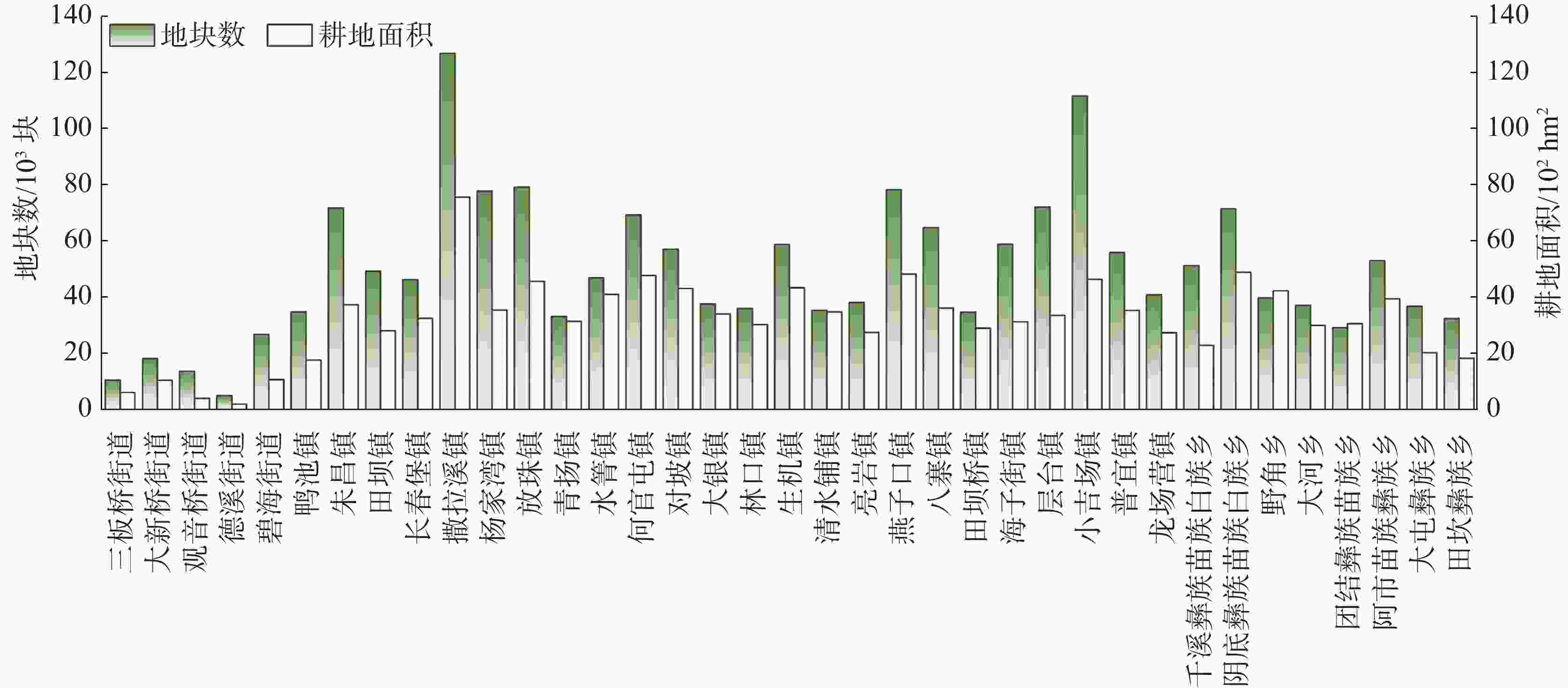
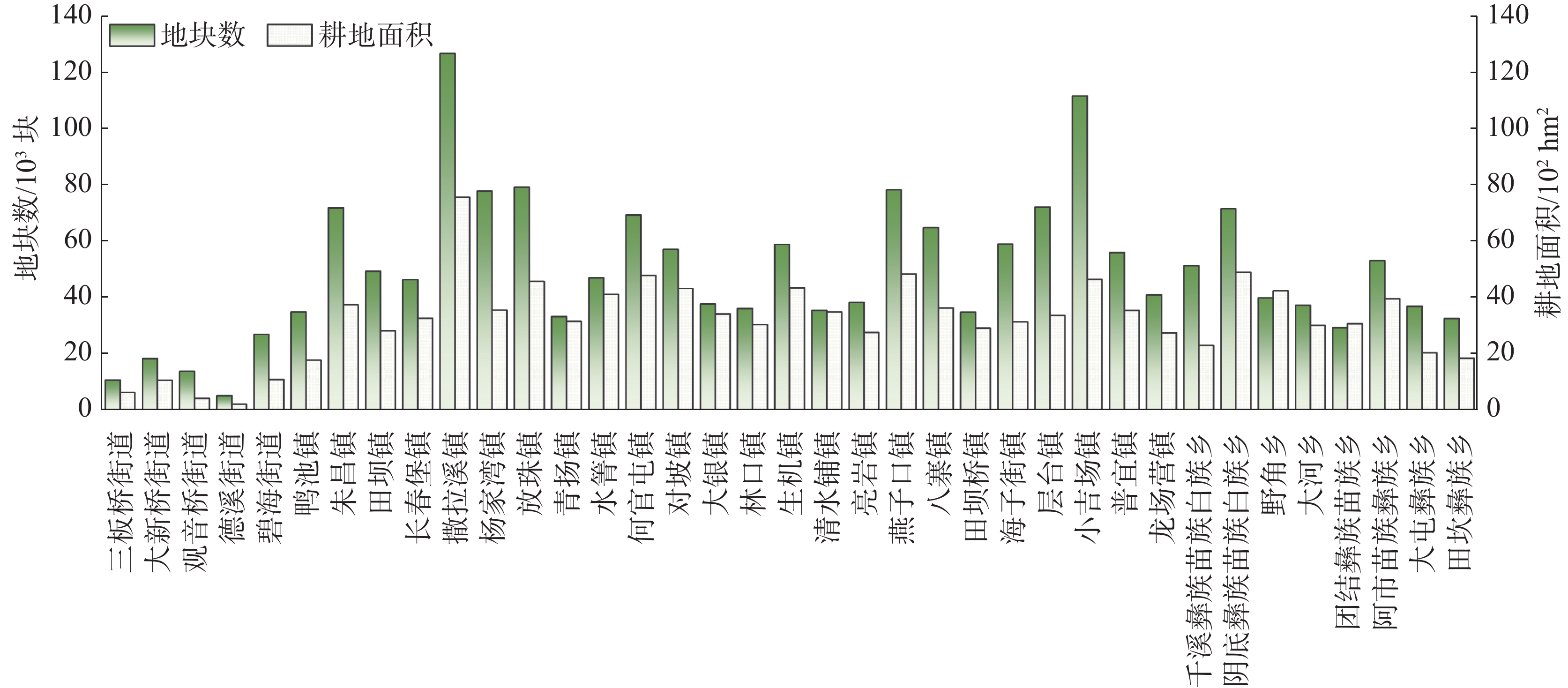
图 2 七星关区各乡镇耕地面积与地块数
Figure 2. Cultivated land area and the number of plots in each township in Qixingguan District
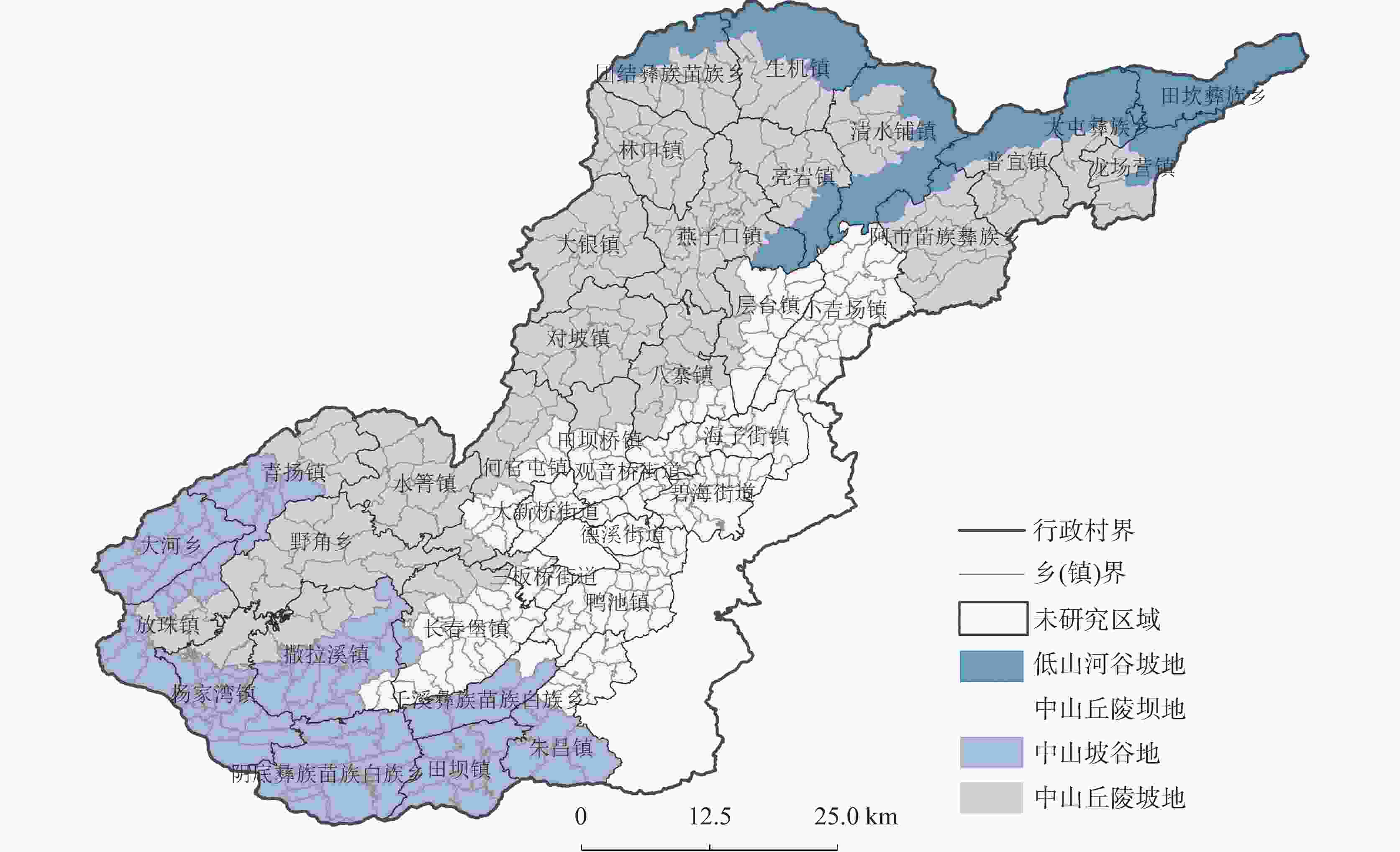
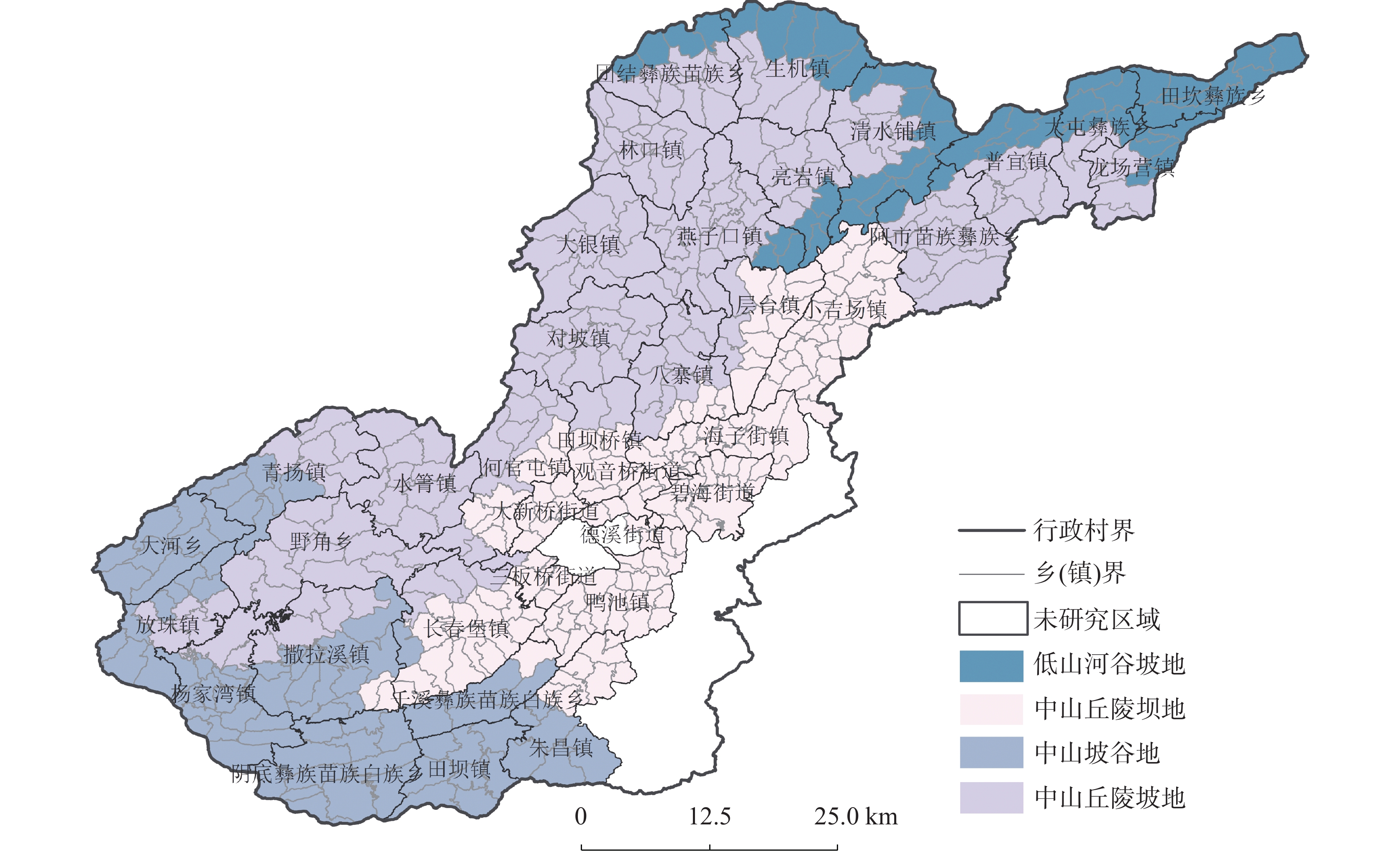
图 3 七星关区地貌类型空间分布图
Figure 3. Spatial distribution map of landform types in Qixingguan District
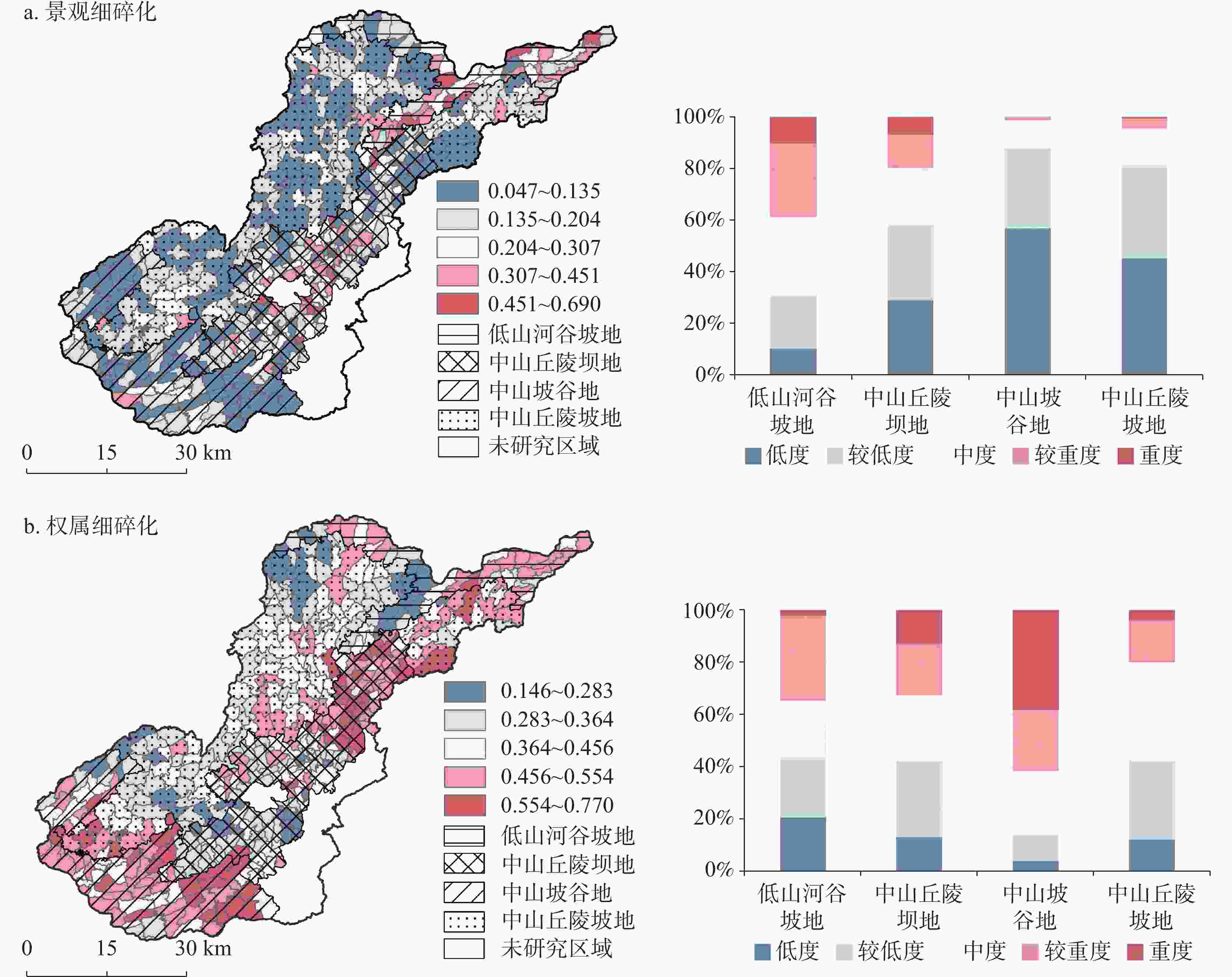
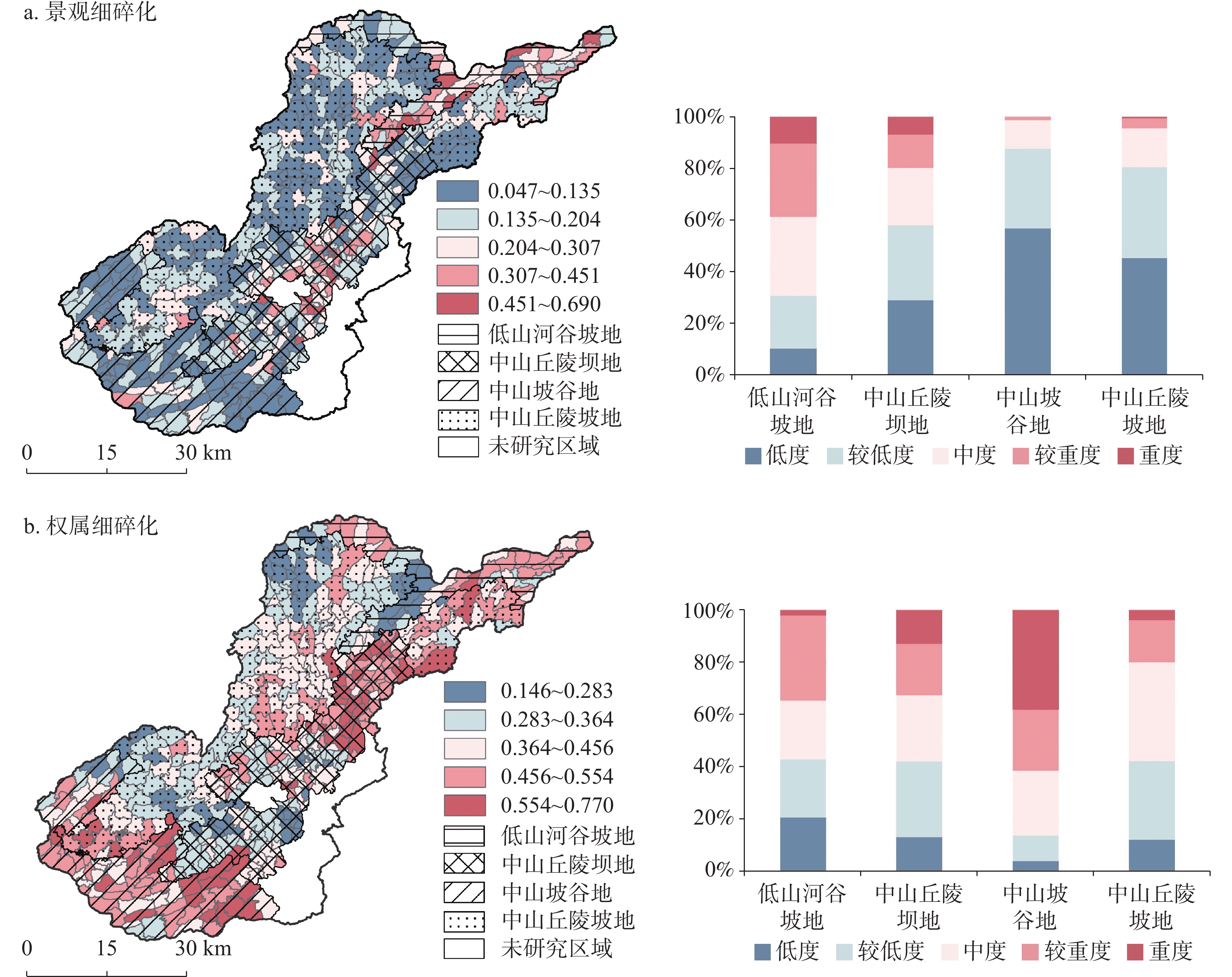
图 4 不同地貌区耕地细碎化空间格局及其占比情况
Figure 4. Spatial pattern and proportion of cultivated land fragmentation in different geomorphic zones
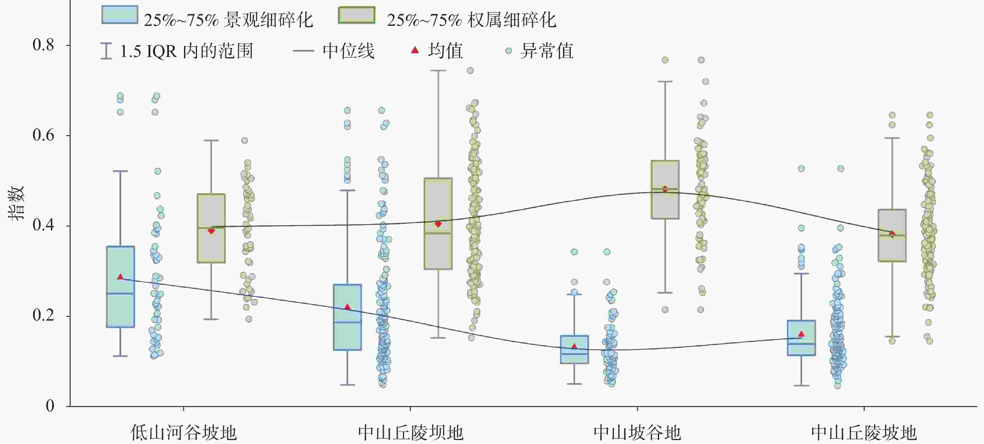
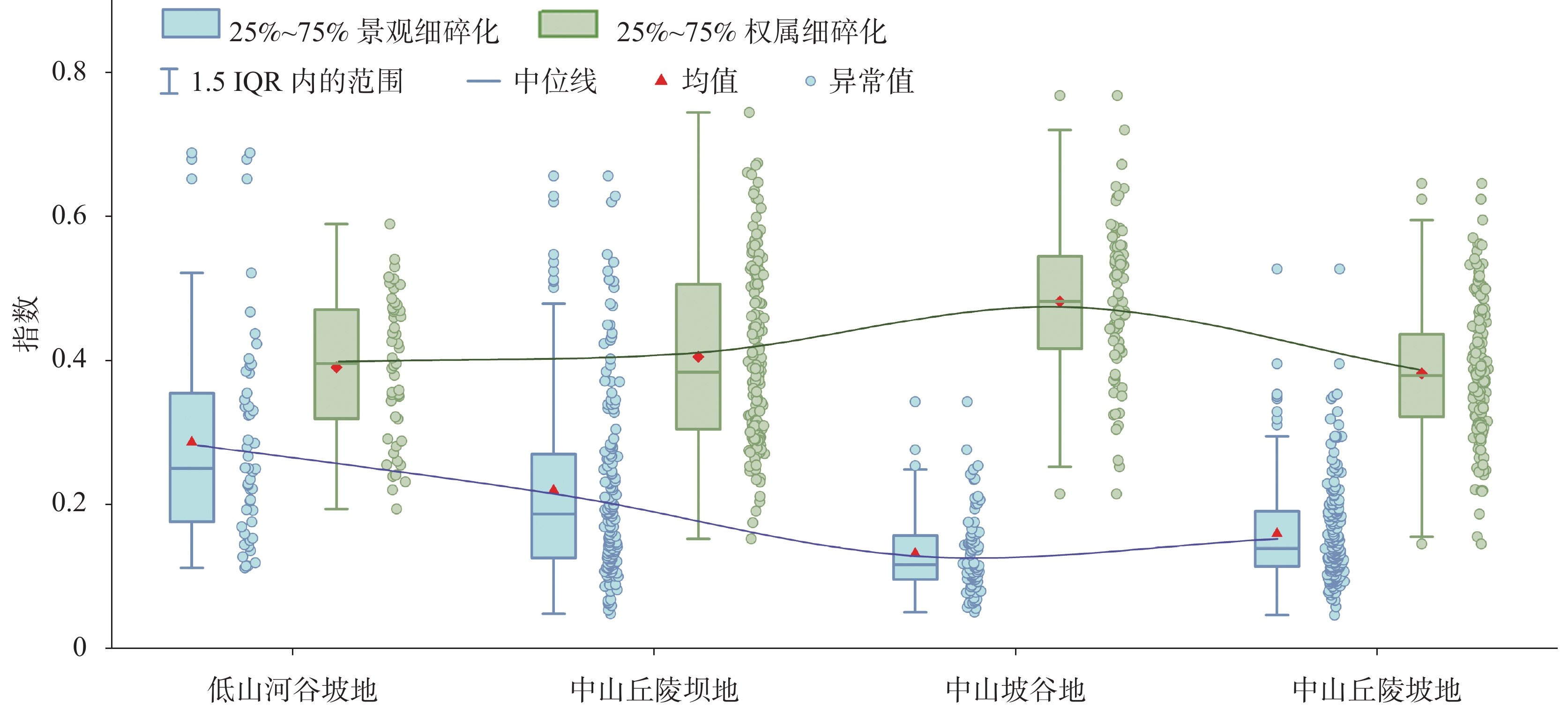
图 5 不同地貌区耕地细碎化分异特征
Figure 5. Differentiation characteristics of cultivated land fragmentation in different geomorphic zones
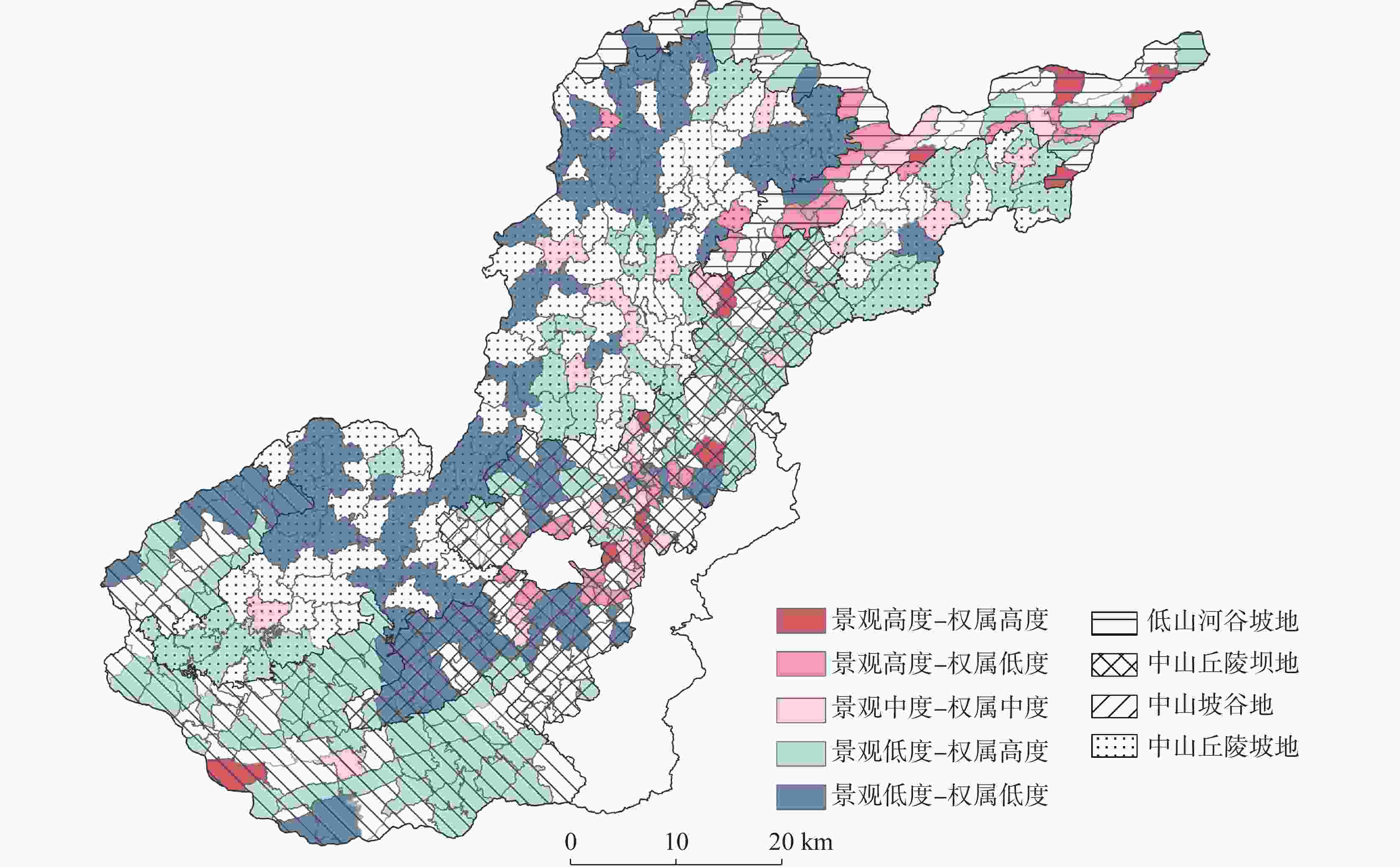
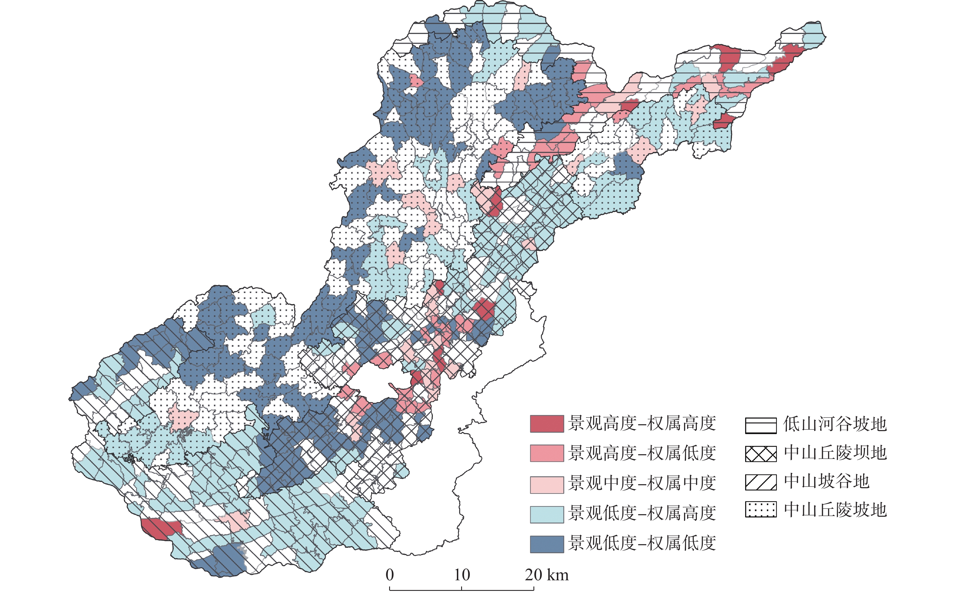
图 6 不同地貌分区综合细碎化模式的空间格局
Figure 6. Spatial pattern of integrated fragmentation patterns in different geomorphic zones
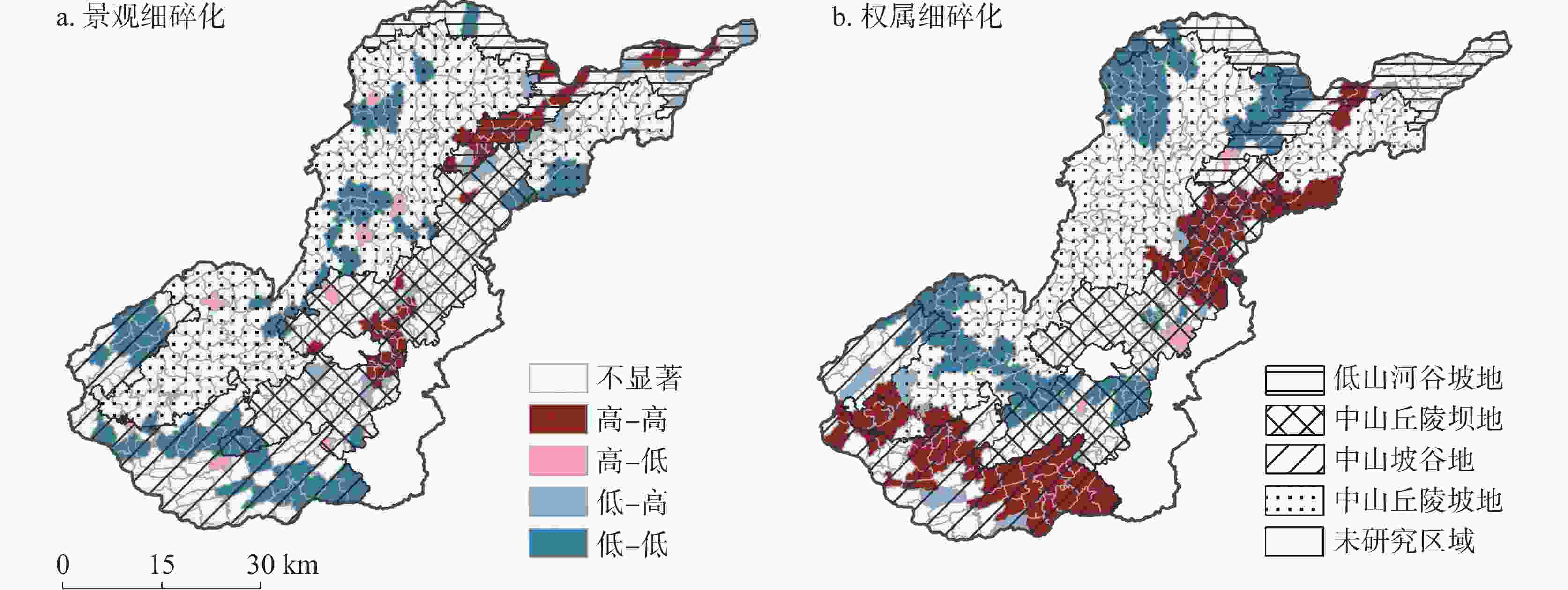
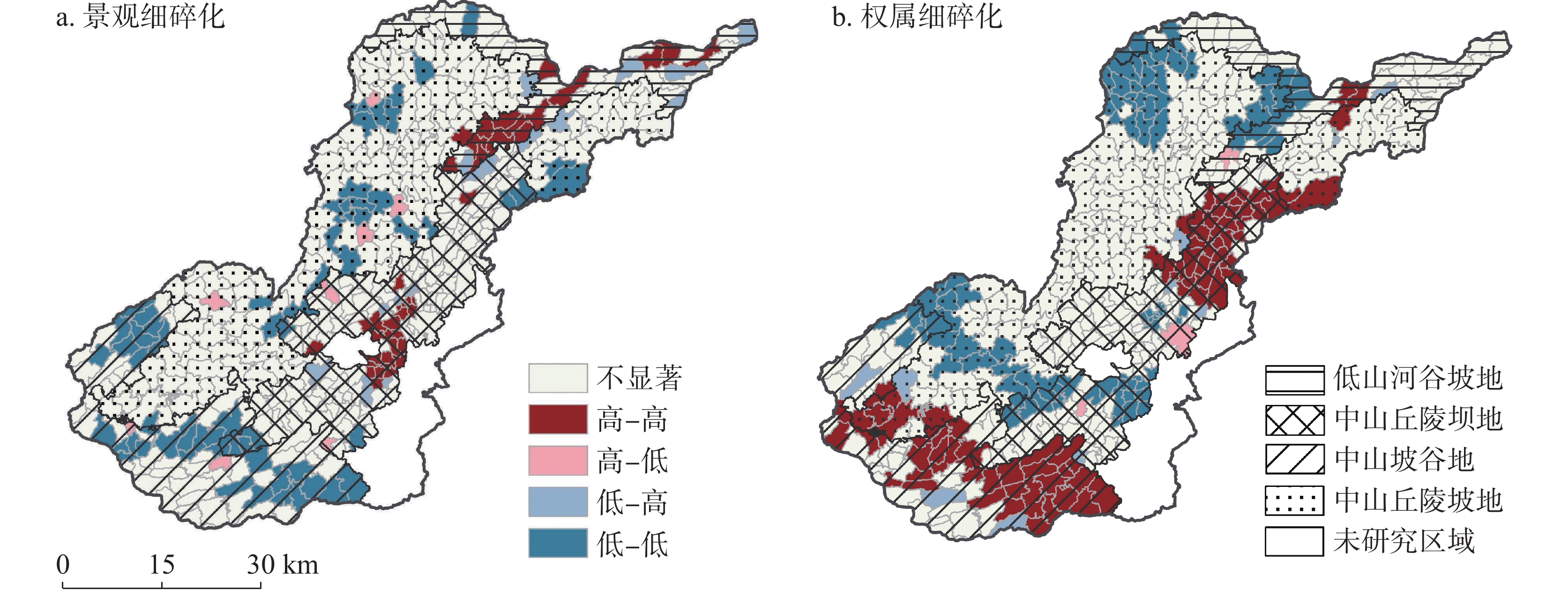
图 7 耕地细碎化指数空间关联局部指标(LISA)集聚图
Figure 7. LISA cluster map of cultivated land fragmentation
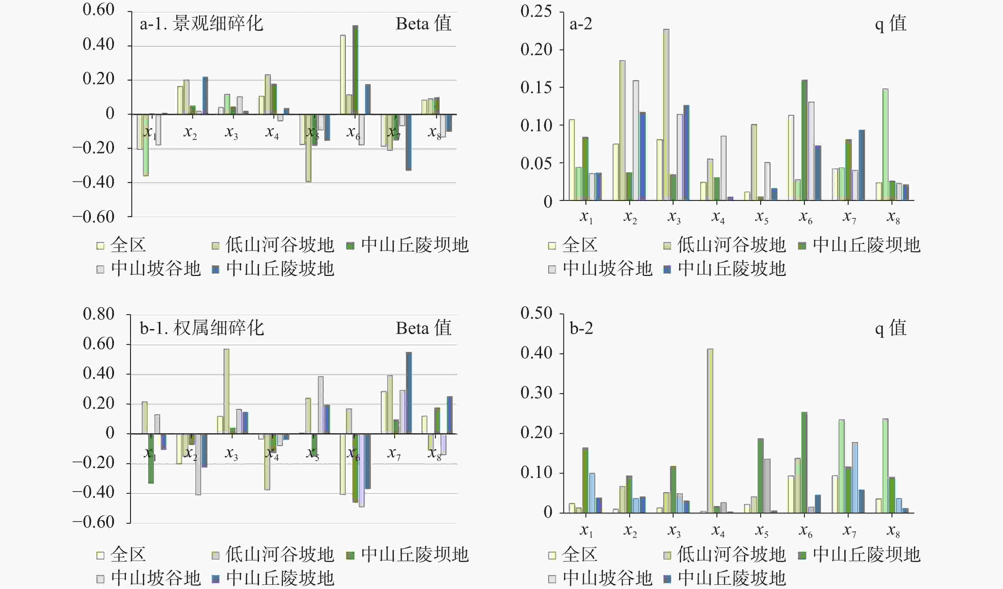
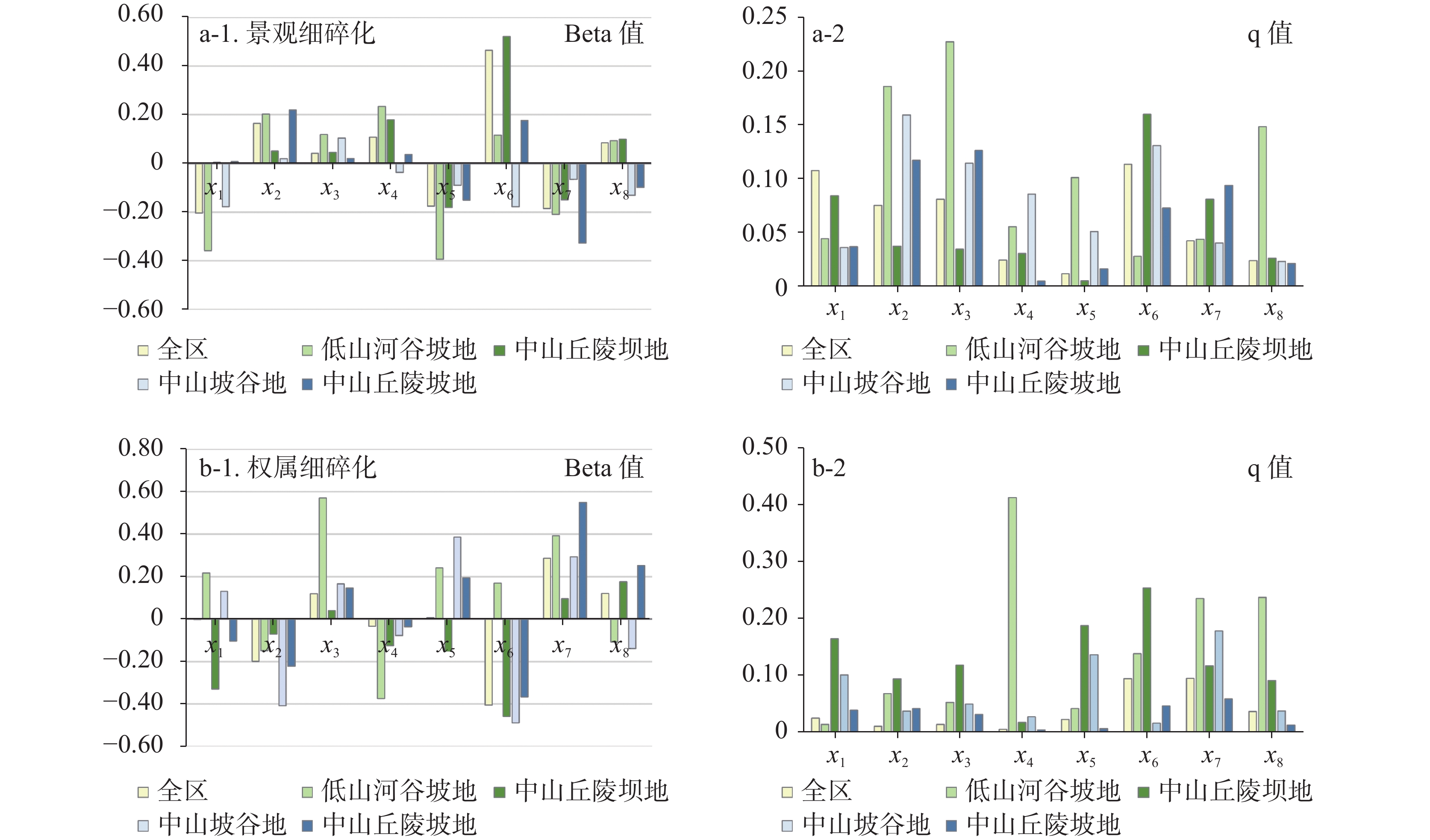
图 8 耕地细碎化各影响因素Beta值与q值
Figure 8. Beta values and q values of each influencing factor on cultivated land fragmentation
表 1 地貌类型划分标准
Table 1. Classification criteria for landform types
地貌类型 海拔/m 地形起伏度/m 坡度/° 坝地 − <50 <8 丘陵 − [50,200) [8,30) 低山 [500, 1000 )≥200 ≥30 中山 [ 1000 ,2500 )− −  下载: 导出CSV
表 2 七星关区耕地景观和权属细碎化评价指标体系
Table 2. Evaluation index system for cultivated landscape and tenure fragmentation in Qixingguan district
指标体系 指标层 计算公式 指标说明 指标性质 权重
景观细
碎化耕地斑块密度 $ PD=\dfrac{n}{A} $ 表征单位面积的耕地斑块数 + 0.2118 耕地斑块破碎度 $ FN=\dfrac{(n-1)}{{N}_{c}} $ 表征耕地整体上的细碎化程度 + 0.5208 边界密度 $ ED=\dfrac{E}{A} $ 表征耕地地块的分割程度 + 0.1400 面积加权形状指数 $ AWMSI={\displaystyle\sum}_{i=1}^{n}\left[\left(\dfrac{0.25{P}_{i}}{\sqrt{{a}_{i}}}\right)\left(\dfrac{{a}_{i}}{A}\right)\right] $ 表征耕地地块的形状状况 + 0.1275 权属细
碎化地块数量 $ NP=N $ 表征研究范围内耕地地块数量 + 0.3118 承包农户户均地块数 $ PCN=\dfrac{N}{{F}_{i}} $ 表征已经确权颁证的承包户拥有的耕作地块平均数量 + 0.2097 现有农户户均地块数 $ PNC=\dfrac{N}{F} $ 表征研究区内现有农户拥有的耕作地块平均数量 + 0.2395 户均耕地面积 $ HCA=\dfrac{LA}{F} $ 表征研究区内单个农户拥有的耕作地块面积 − 0.0880 平均地块面积 $ PCA=\dfrac{LA}{N} $ 表征研究区内耕作地块的平均面积 − 0.1510 注:$ A $为研究单元内的三调耕地总面积;$ {N}_{c} $为研究单元内耕地总面积与最小耕地斑块面积的比值;$ E $为研究单元内斑块的总周长; $ {P}_{i} $为斑块周长;$ {a}_{i} $为斑块面积;$ N $为耕作地块数;$ {F}_{i} $为二轮承包确权总户数;$ F $为2021年末统计的评价单元内实际总户数;$ LA $为研究单元内的农村土地承包经营权确权的耕地总面积;+表示指标为正向指标,即值越大,耕地细碎化程度越高;–表示指标为负向指标,情况则与正向指标相反。
下载: 导出CSV
表 3 耕地细碎化影响因素
Table 3. Factors influencing cultivated land fragmentation
影响因素类别 影响因素名称 单位 标志 自然环境 高程 m x1 坡度 ° x2 地形切割度 m x3 石漠化程度 / x4 社会经济发展 道路面积 km2 x5 建设用地比例 % x6 农村人口密度 人·hm−2 x7 人均耕地面积 hm2·人−1 x8
下载: 导出CSV
表 4 不同地貌分区行政村个数及占比情况
Table 4. Number and proportion of administrative villages by different geomorphic divisions
细碎化 地貌分区 低度 较低度 中度 较重度 重度 景观细碎化 低山河谷坡地 5(10.20) 10(20.41) 15(30.61) 14(28.57) 5(10.20) 中山丘陵坝地 47(29.01) 47(29.01) 36(22.22) 21(12.96) 11(6.79) 中山坡谷地 46(56.79) 25(30.86) 9(11.11) 1(1.23) 0(0.00) 中山丘陵坡地 84(45.41) 65(35.14) 28(15.14) 7(3.78) 1(0.54) 182(38.16) 147(30.82) 88(18.45) 43(9.22) 17(3.35) 权属细碎化 低山河谷坡地 10(20.41) 11(22.45) 11(22.45) 16(32.65) 1(2.04) 中山丘陵坝地 21(12.96) 47(29.01) 41(25.31) 32(19.75) 21(12.96) 中山坡谷地 3(3.70) 8(9.88) 20(24.69) 19(23.46) 31(38.27) 中山丘陵坡地 22(11.89) 56(30.27) 70(37.84) 30(37.84) 7(3.78) 55(11.74) 122(25.58) 142(29.77) 97(20.34) 60(12.58)
下载: 导出CSV
表 5 不同地貌分区行政村个数及占比情况
Table 5. Number and proportion of administrative villages by different geomorpic divisions
景观低度细碎–
权属低度细碎景观低度细碎–
权属高度细碎景观中度细碎–
权属中度细碎景观高度细碎–
权属低度细碎景观高度细碎–
权属高度细碎低山河谷坡地 3(10.34) 8(27.57) 2(6.90) 12(41.38) 4(13.79) 中山丘陵坝地 35(35.35) 29(29.29) 12(12.12) 18(18.18) 5(5.05) 中山坡谷地 11(20.37) 41(75.93) 1(1.85) 0(0.00) 1(1.85) 中山丘陵坡地 62(57.94) 32(29.91) 10(9.35) 3(2.80) 0(0.00) 总计 111(23.27) 110(23.06) 25(5.24) 33(6.92) 10(2.10)
下载: 导出CSV
表 6 全局自相关分析报表
Table 6. Global spatial autocorrelation analysis
类型 景观指数 权属指数 全局Moran I 指数 0.2882 0.5481 预期指数 − 0.0021 − 0.0021 检验统计量z 10.6733 19.9652 p-value 0 0
下载: 导出CSV
表 7 地貌分区与耕地细碎化指数空间自相关对应的行政村数量
Table 7. Number of administrative villages corresponding to the spatial autocorrelation between geomorphic divisions and cultivated land fragmentation index
类型 景观指数 权属指数 低山河谷坡地 中山丘陵坝地 中山坡谷地 中山丘陵坡地 低山河谷坡地 中山丘陵坝地 中山坡谷地 中山丘陵坡地 H-H 15 27 1 0 2 43 36 6 H-L 0 1 3 3 1 2 0 0 L-L 1 8 30 27 11 42 5 32 L-H 4 9 0 3 1 3 3 3
下载: 导出CSV
-
[1] 杜国明, 盖兆雪, 王洪彦. 中国耕地细碎化的理论解析与研究框架[J]. 地球科学与环境学报, 2021, 43(6): 997-1008. doi: 10.19814/j.jese.2021.07029DU Guoming, GAI Zhaoxue, WANG Hongyan. Theoretical explanation and research framework of cultivated-land fragmentation in China[J]. Journal of Earth Science and Environment, 2021, 43(6): 997-1008. doi: 10.19814/j.jese.2021.07029 [2] 李昊, 银敏华, 马彦麟, 康燕霞, 贾琼, 齐广平, 汪精海. 种植规模与细碎化对小农户耕地质量保护行为的影响: 以蔬菜种植中农药、化肥施用为例[J]. 中国土地科学, 2022, 36(7): 74-76.LI Hao, YIN Minhua, MA Yanlin, KANG Yanxia, JIA Qiong, QI Guangping, WANG Jinghua. Effects of planting scale and fragmentation on the behavior of smallholders' farmland quality protection: Taking the application of pesticide and fertilizer in vegetable cultivation as an example[J]. China Land Science, 2022, 36(7): 74-76. [3] 张蚌蚌, 孔祥斌. 基于细碎化的中国近30年耕地利用系统变化及耦合协调度[J]. 北京师范大学学报, 2018, 54(3): 327-333. doi: 10.16360/j.cnki.jbnuns.2018.03.008ZHANG Bangbang, KONG Xiangbin. Changes and coupling coordination degree of cultivated land use system in recent 30 years based on fragmentation perspective in China[J]. Journal of Beijing Normal University, 2018, 54(3): 327-333. doi: 10.16360/j.cnki.jbnuns.2018.03.008 [4] Binns B. The Consolidation of Fragmented Agricultural Holdings[M]. Washington: Food and Agriculture Organization of the United Nations, 1950: 11. [5] King R L. Land fragmentation: Notes on a fundamental rural spatial problem[J]. Progress in Human Geography, 1982, 6(4): 475-494. doi: 10.1177/030913258200600401 [6] Sabates-Wheeler R. Farm strategy, self-selection and productivity: Can small farming groups offer production benefits to farmers in post-socialist Romania[J]. World Development, 2002, 30(10): 1737-1753. doi: 10.1016/S0305-750X(02)00063-3 [7] 吕晓, 黄贤金, 钟太洋, 赵雲泰. 中国农地细碎化问题研究进展[J]. 自然资源学报, 2011, 26(3): 530-540.LYU Xiao, HUANG Xianjin, ZHONG Taiyang, ZHAO Yuntai. Review on the research of farmland fragmentation in China[J]. Journal of Natural Resources, 2011, 26(3): 530-540. [8] 许玉光, 杨钢桥, 文高辉. 耕地细碎化对耕地利用效率的影响: 基于不同经营规模农户的实证分析[J]. 农业现代化研究, 2017, 38(4): 688-695. doi: 10.13872/j.1000-0275.2017.0056XU Yuguang, YANG Gangqiao, WEN Gaohui. Impacts of arable land fragmentation on land use efficiency: An empirical analysis based on farms of different scales[J]. Research on Agricultural Modernization, 2017, 38(4): 688-695. doi: 10.13872/j.1000-0275.2017.0056 [9] 刘立文, 段永红, 徐立帅, 袁晓梅. 黄土丘陵区耕地细碎化特征及影响因素研究: 以山西省和顺县为例[J]. 中国农学通报, 2021, 37(22): 90-96.LIU Liwen, DUAN Yonghong, XU Lishuai, YUAN Xiaomei. Characteristics and influencing factors of cultivated land fragmentation in Loess hilly region: A case study of Heshun County in ShanXi Province[J]. Chinese Agronomy Bulletin, 2021, 37(22): 90-96. [10] Zhao Y, Feng Q. Identifying spatial and temporal dynamics and driving factors of cultivated land fragmentation in Shaanxi Province[J]. Agricultural Systems, 2024, 217. DOI: 10.1016/j.agsy.2024.103948. [11] 任红玉, 赵宇鸾, 葛玉娟. 喀斯特山区耕地细碎化与地貌类型的空间关联性: 以贵州修文县为例[J]. 贵州师范大学学报(自然科学版), 2020, 38(4): 1-9.REN Hongyu, ZHAO Yuluan, GE Yujuan. The correlation research between cultivated land fragmentation and landformin karst mountainous areas: A case of Xiuwen County, Guizhou Province[J]. Journal of Guizhou Normal University (Natural Science Edition), 2020, 38(4): 1-9. [12] 杜国明, 张宇, 章尤琴. 东北黑土区典型县域耕地细碎化空间格局及影响因素分析[J]. 农业现代化研究, 2023, 44(5): 858-868.DU Guoming, ZHANG Yu, ZHANG Youqin. Spatial pattern and influencing factors of cultivated land fragmentation in typical counties of Northeast black soil region[J]. Research on Agricultural Modernization, 2023, 44(5): 858-868. [13] Abubakari Z, Van der Molen P, Bennett R M, Kuusaana E D. Land consolidation, customary lands, and Ghana's Northern Savannah Ecological Zone: An evaluation of the possibilities and pitfalls[J]. Land Use Policy, 2016, 54(7): 386-398. doi: 10.1016/j.landusepol.2016.02.033 [14] Yucer A, Kan M, Demirtas M, Kalanlar S. The importance of creating new inheritance policies and laws that reduce agricultural land fragmentation and its negative impacts in Turkey[J]. Land Use Policy, 2016, 56(11): 1-7. [15] Qiu F, Laliberté L, Swallow B, Jeffrey S. Impacts of fragmentation and neighbor influences on farmland conversion: A case study of the Edmonton-Calgary Corridor, Canada[J]. Land Use Policy, 2015, 48(1): 482-494. doi: 10.1016/j.landusepol.2015.06.024 [16] Zhou Y R, Chen T Q, Feng Z, Wu K N. Identifying the contradiction between the cultivated land fragmentation and the construction land expansion from the perspective of urban-rural differences[J]. Ecological Informatics, 2022, 71: 101826. [17] 吴明凤, 李容, 杨宇. 土地细碎化背景下地块生产趋同对农户购置农机的影响[J]. 西北农林科技大学学报(社会科学版), 2017, 17(2): 113-122. doi: 10.13968/j.cnki.1009-9107.2017.02.15WU Mingfeng, LI Rong, YANG Yu. Analysis of impact of land fragmentation on farmers' agricultural machinery purchase decision[J]. Journal of Northwest Agriculture and Forestry University (Social Science Edition), 2017, 17(2): 113-122. doi: 10.13968/j.cnki.1009-9107.2017.02.15 [18] 文高辉, 杨钢桥, 汪文雄, 赵微. 基于农户视角的耕地细碎化程度评价: 以湖北省“江夏区—咸安区—通山县”为例[J]. 地理科学进展, 2016, 35(9): 1129-1143.WEN Gaohui, YANG Gangqiao, WANG Wenxiong, ZHAO Wei. Evaluation of cultivated land fragmentation degree based on farmers' perspective: A case of Jiangxia District, Xian'an District, and Tongshan County in Hubei Province[J]. Progress in Geoscience, 2016, 35(9): 1129-1143. [19] 李鹏山, 吕雅慧, 张超, 勋文聚, 杨建宇, 朱德海. 基于核密度估计的京津冀地区耕地破碎化分析[J]. 农业机械学报, 2016, 47(5): 281-287.LI Pengshan, LYU Yahui, ZHANG Chao, XUN Wenjun, YANG Jianyu, ZHU Dehai. Analysis of cultivated land fragmentation in Beijing-Tianjin-Hebei region based on kernel density estimation[J]. Journal of Agricultural Machinery, 2016, 47(5): 281-287. [20] 张睿思, 叶思菁, 任书义. 基于 MGWR 模型的江苏省耕地细碎度空间格局与驱动因素分析[J]. 农业工程学报, 2024, 40(16): 229-239.ZHANG Ruisi, YE Sijing , REN Shuyi. Spatial pattern and driving factors of cultivated land fragmentation in Jiangsu Province using MGWR model[J].Transactions of the Chinese Society of Agricultural Engineering, 2024, 40(16): 229-239. [21] 梁兴海, 陈英. 兰州市永登县耕地细碎化及其影响因素的空间相关性分析[J]. 国土与自然资源研究, 2021(4): 11-15.LIANG Xinghai, CHEN Ying. Spatial correlation analysis of farmland fragmentation and its influencing factors in Yongdeng County, Lanzhou City[J]. Territory & Natural Resources Study, 2021(4): 11-15. [22] 张宏伟, 杨恩林, 焦树林, 王贵云, 杨善进. 七星关区耕地土壤Ge地球化学特征及其与作物的吸收关系[J]. 物探与化探, 2024, 48(2): 534-544, 554.ZHANG Hongwei, YANG Enlin, JIAO Shulin, WANG Guiyun, YANG Shanjin. Ge in soils of cultivated Qixingguan District: Geochemical characteristics and absorption by crops[J]. Geophysical and Geochemical Exploration, 2024, 48(2): 534-544, 554. [23] 张宇, 罗为群, 刘美玲, 李梦琦, 张莉, 陈芳芳, 张扬岑, 陈蕊. 岩石风化碳汇遥感估算及其时空变化分析[J]. 中国岩溶, 2024, 43 (4): 727-741.ZHANG Yu, LUO Weiqun, LIU Meiling, LI Mengqi, ZHANG Li, CHEN Fangfang, ZHANG Yangcen, CHEN Rui. Estimation of the carbon sink of rock weathering by remote sensing and analysis of its spatiotemporal variations[J]. Carsologica Sinica, 2024, 43 (4): 727-741. [24] 钟祥浩, 刘淑珍. 中国山地分类研究[J]. 山地学报, 2014, 32(2): 129-140.ZHONG Xianghao, LIU Shuzhen. Research on the mountain classification in China[J]. Mountain Research, 2014, 32(2): 129-140. [25] 赵宇鸾, 李秀彬, 张颖. 黔桂喀斯特山地与山区类型划分技术与应用[J]. 地球信息科学学报, 2017, 19(7): 934-940.ZHAO Yuluan, LI Xiubin, ZHANG Ying. Technology and application of mountainous area divisions in Qian-Gui karst areas[J]. Journal of Geo-Information Science, 2017, 19(7): 934-940. [26] Liu J, Jin X B, Xu W Y, Zhou Y K. Evolution of cultivated land fragmentation and its driving mechanism in rural development: A case study of Jiangsu Province[J]. Journal of Rural Studies, 2022, 91: 58−72. [27] 李鑫, 欧名豪, 马贤磊. 基于景观指数的细碎化对耕地利用效率影响研究: 以扬州市里下河区域为例[J]. 自然资源学报, 2011, 26(10): 1758-1767.LI Xin, OU Minghao, MA Xianlei. Analysis on impact of fragmentation based on landscape index to cultivated land use efficiency: A case on Lixiahe district in Yangzhou City[J]. Journal of Natural Resources, 2011, 26(10): 1758-1767. [28] Ntihinyurwa P D, de Vries W T. Farmland fragmentation concourse: Analysis of scenarios and research gaps[J]. Land Use Policy, 2021, 100: 104936. [29] Ye S J, Ren S Y, Song C Q, Du Z B, Wang K X, Du B, Cheng F, Zhu D H. Spatial pattern of cultivated land fragmentation in mainland China: Characteristics, dominant factors, and countermeasures[J]. Land Use Policy, 2024, 107070. [30] 王千, 金晓斌, 周寅康. 河北省耕地生态安全及空间聚集格局[J]. 农业工程学报, 2011(8): 348-354. doi: 10.3969/j.issn.1002-6819.2011.08.059WANG Qian, JIN Xiaobin, ZHOU Yinkang. Cultivated land ecological security and spatial aggregation pattern in Hebei Province[J]. Transactions of the Chinese Society of Agricultural Engineering , 2011(8): 348-354. doi: 10.3969/j.issn.1002-6819.2011.08.059 [31] Hartvigsen M. Land reform and land fragmentation in central and eastern Europe[J]. Land Use Policy, 2014, 36: 330-341. doi: 10.1016/j.landusepol.2013.08.016 [32] Xu W Y, Jin X B, Liu J, Zhou Y K. Impact of cultivated land fragmentation on spatial heterogeneity of agricultural agglomeration in China[J]. Journal of Geographical Sciences, 2020, 30(10): 1571-1589. doi: 10.1007/s11442-020-1800-1 [33] 贺凯凯, 陈清敏, 成星, 杨治国, 韩静, 曹江涛, 艾昊, 张文硕. 中国西南及陕西秦巴地区岩溶石漠化研究进展[J]. 中国岩溶, 2024, 43(1): 147-162.HE Kaikai, CHEN Qingmin, CHENG Xing, YANG Zhiguo, HAN Jing, CAO Jiangtao, AI Hao, ZHANG Wenshuo. Research progress on karst rocky desertification in Southwest China and the Qinba region of Shaanxi Province. Carsologica Sinica, 2024, 43(1): 147-162. [34] Liu J, Jin X B, Xu W Y, Sun R, Han B, Yang X, Gu Z, Xu C, Sui X, Zhou Y K. Influential factors and classification of cultivated land fragmentation, and implications for future land consolidation: A case study of Jiangsu Province in eastern China[J]. Land Use Policy, 2019, 88: 104185. doi: 10.1016/j.landusepol.2019.104185 [35] Wang J F, Hu Y. Environmental health risk detection with GeoDetector[J]. Environmental Modeling & Software, 2012, 33(7): 114-115. [36] 周璐红, 张怡琳. 基于国土空间适宜性与迫切性评价的国土空间整治分区研究: 以镇安县为例[J]. 贵州师范大学学报(自然科学版), 2025, 43(4): 52-60. doi: 10.16614/j.gznuj.zrb.2025.04.006ZHOU Luhong, ZHANG Yilin. Research on land space remediation zoning based on the evaluation of land space suitability and urgency: Taking Zhen'an county as an example[J]. Journal of Guizhou Normal University (Natural Sciences), 2025, 43(4): 52-60. doi: 10.16614/j.gznuj.zrb.2025.04.006 [37] 张皓茹, 杨坪坪, 高雄, 李永, 杨昌鑫. 基于RUSLE模型的贵州省植被景观格局演变对土壤保持的影响[J]. 贵州师范大学学报(自然科学版), 2025, 43(1): 46-59. doi: 10.16614/j.gznuj.zrb.2025.01.005ZHANG Haoru, YANG Pingping, GAO Xiong, LI Yong, YANG Changxin. An analysis of the impact of vegetation landscape pattern evolution on soil conservation in Guizhou Province by utilizing the RUSLE model[J]. Journal of Guizhou Normal University (Natural Sciences), 2025, 43(1): 46-59. doi: 10.16614/j.gznuj.zrb.2025.01.005 [38] 左太安, 张凤太, 于世杰, 黎娇, 樊昊, 叶丹. 中国岩溶地区石漠化贫困问题研究进展[J]. 中国岩溶, 2022, 41(6): 915-927.ZUO Taian, ZHANG Fengtai, YU Shijie, LI Jiao, FAN Hao, YE Dan. A study on poverty caused by rocky desertification in karst areas of China[J]. Carsologica Sinica, 2022, 41(6): 915-927. -

 点击查看大图
计量
- 文章访问数: 305
- HTML浏览量: 138
- PDF下载量: 15
- 被引次数: 0
