

Multi-scale response characteristics of extreme hydrological events and reservoir regulation effects in the Pearl River Delta
-
摘要: 珠江三角洲长期面临极端水文事件与人类活动的双重挑战,导致洪旱灾害频发、咸潮上溯加重,上游复杂的岩溶地下水—地表水耦合过程增强了流量的突变性和调节不确定性。为了揭示珠江三角洲极端水文流量的多尺度演变规律,评估水库调控在防洪抗旱中的关键作用,文章基于2006—2017年的7个水文站和1个水库日流量数据,综合应用Mann-Kendall趋势检验、Gumbel/Gamma极值分布模型及水库调节比率模型,解析流量趋势、极端事件特征与水库调控效应。结果表明西江马口站与北江三水站流量每年显著增长(171.417、50.254 m3∙s−1),东江博罗站受调水工程影响趋势不显著。西江10年一遇洪峰达
58846 m3∙s−1,北江20年一遇枯水流量降至53.38 m3∙s−1,区域性风险差异显著。下游河水上溯天数年均增加12%,海平面上升与上游来水减少是主因。水库调控具有显著的削峰填谷效应,洪水期削峰比达0.3~0.9,枯水期支撑比超0.8,有效缓解洪旱灾害。气候变化与人类活动协同驱动珠江水文极端化,水库调控是平衡防洪与抗旱的核心手段,研究为区域水资源韧性管理提供科学依据。Abstract: The Pearl River Delta (PRD) is experiencing increased hydroclimatic variability alongside intensive human regulation, resulting concurrent risks of floods, droughts, and saltwater intrusion. This study examines multi-scale changes in extreme flow events and quantifies reservoir regulation, with attention to the combined effects of upstream karst–surface water interactions and downstream tidal dynamics. We compiled daily discharge and precipitation records from seven representative stations across upstream, midstream, and downstream reaches, along with operational data from one key reservoir, covering the period from 2006 to 2017. Methods include the Mann-Kendall test with linear slope estimation for trend detection, seasonal indices for flood−drought allocations, extreme value models (Gumbel distribution for flood peaks and Gamma distribution for low flows), and a physically interpretable reservoir regulation ratio R. This ratio isolates the operational contribution of the reservoir under varying hydrological regimes. Trend diagnostics indicate significant increases in annual flow at Makou (the Xijiang River) and Sanshui (the Beijiang River), while Boluo (the Dongjiang River) shows no monotonic trend. Estimated slopes are approximately 171.4 and 50.3 m3·s−1 at Makou and Sanshui, respectively. Seasonal indices reveal that upstream stations retain a pronounced flood-season amplification consistent with natural precipitation variability; midstream stations exhibit stabilization due to regulation; and downstream stations, influenced by tidal backwater and diversions, display more balanced flood-drought allocations. Frequency analysis reveals spatially contrasting hazards. At Makou, the 10-year flood is about 5.9×10⁴ m3·s−1, reflecting strong basin-scale concentration and operational constraints during heavy rainfall. For drought risk, the 20-year low flow at Sanshui is 53 m3·s−1, indicating elevated supply risk during prolonged deficits. The Gamma model for low flows avoids nonphysical negative values and preserves the lower-tail behavior needed for drought design. Overall, flood hazard scales with contributing area (Boluo<Sanshui<Makou), whereas drought vulnerability is station-specific, shaped by both regulation and tidal backwater. Downstream, days with flow reversal (upstream-directed velocity), which diagnose tidal dominance and salt-intrusion propensity, have increased over the study period. Reversal-day counts rise by 12% on average and cluster in the dry season (December-March), when upstream inflows are minimal. This trend is consistent with sea-level rise and dredging-altered hydraulics that enhance tidal penetration. The regulation ratio R captures operational fingerprints across regimes. During flood seasons, R<1 dominates, indicating peak shaving; typical events yield between 0.3 and 0.9. In dry seasons, R>1 occurs frequently, with support ratios above 0.8 in most years, showing active augmentation of downstream flows for ecological and municipal needs. The R series exhibits spikes during basin-wide droughts (emergency releases) and troughs during intercepted flood peaks, directly evidencing dual mitigation by storage.Synthesizing the results, climate change and human activities jointly polarize the PRD hydrologic regime, resulting higher flood peaks and lower low flows upstream, and more frequent tidal reversals downstream. Large reservoirs serve as effective tools for managing the flood-drought trade-off by reducing peak discharges while maintaining environmental flows, but they also alter natural hydrographs and sediment-morphodynamic processes. The proposed R metric provides a concise, physically grounded indicator for diagnosing and comparing regulatory efficacy across events and years, as well as for communicating operational targets under multi-hazard constraints. Although the analysis is limited by the 2006 to 2017 record and idealizations in tributary corrections, the framework is transferable to other mixed karst/non-karst river systems facing compound hazards. -
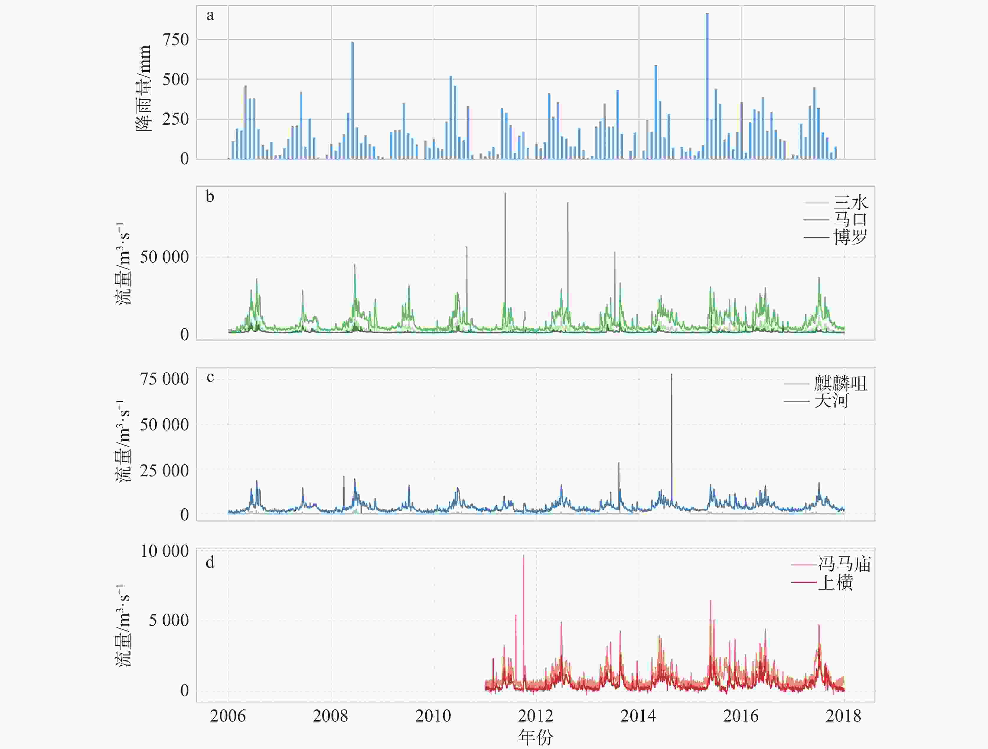
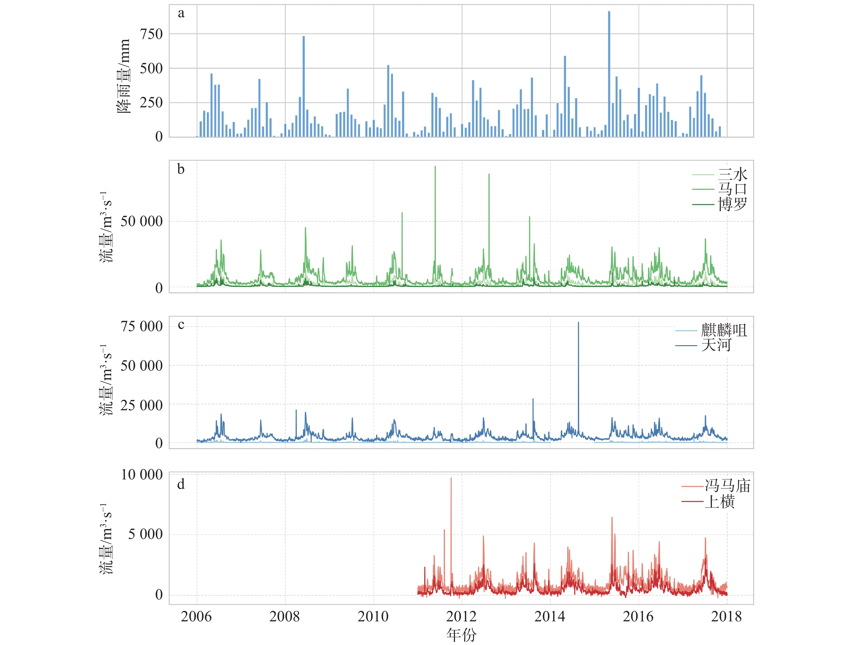
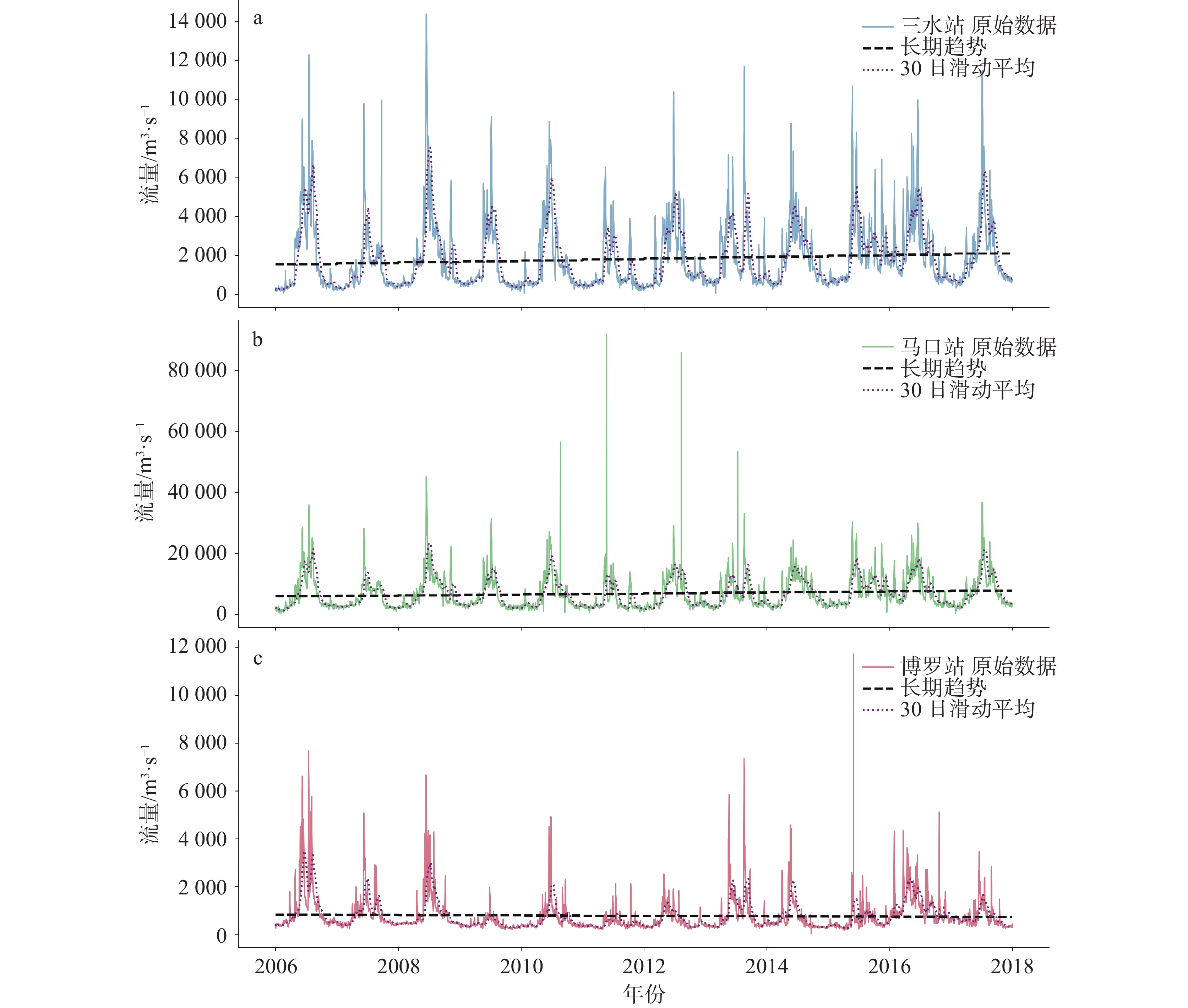
图 2 珠三角水文站2006—2017年月均流量变化
Figure 2. Monthly flow variations at hydrological stations in the Pearl River Delta (from 2006 to 2017)
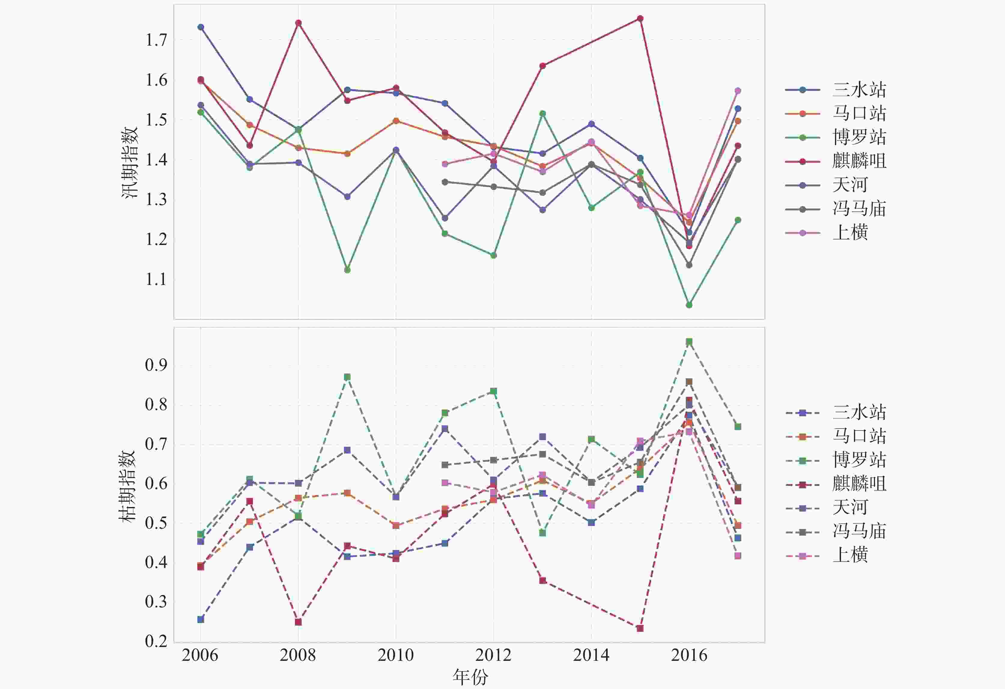
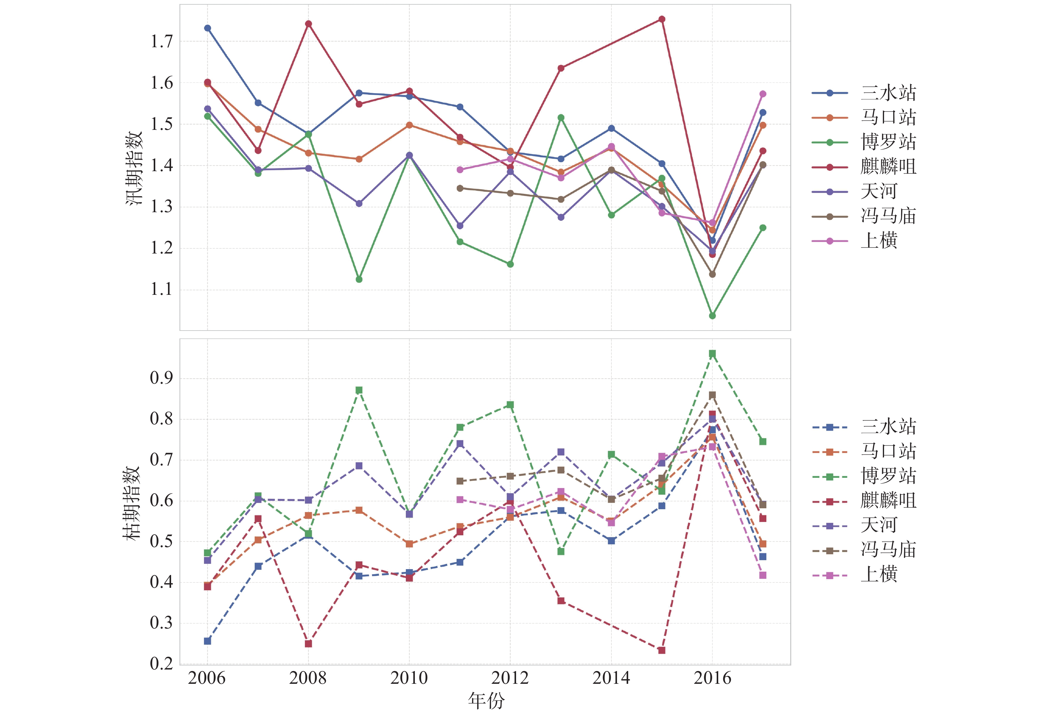
图 4 各水文站汛期/枯期指数变化图
Figure 4. Seasonal index variations (the flood season vs. the dry season) at hydrological stations
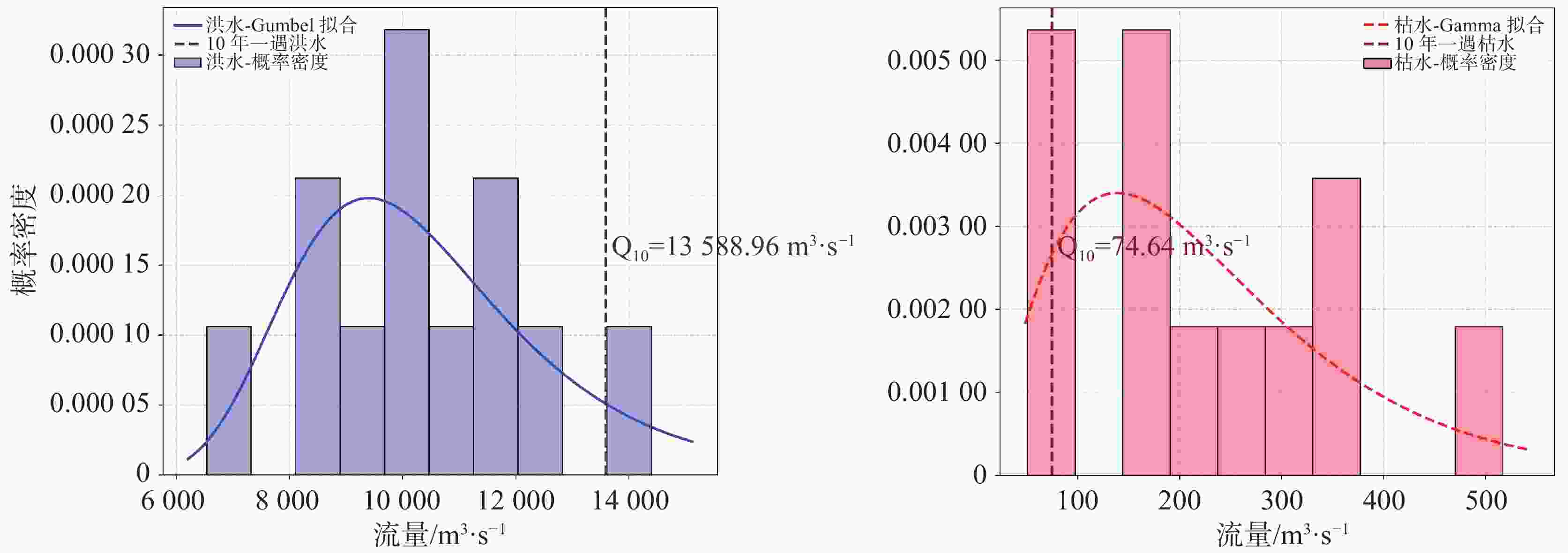
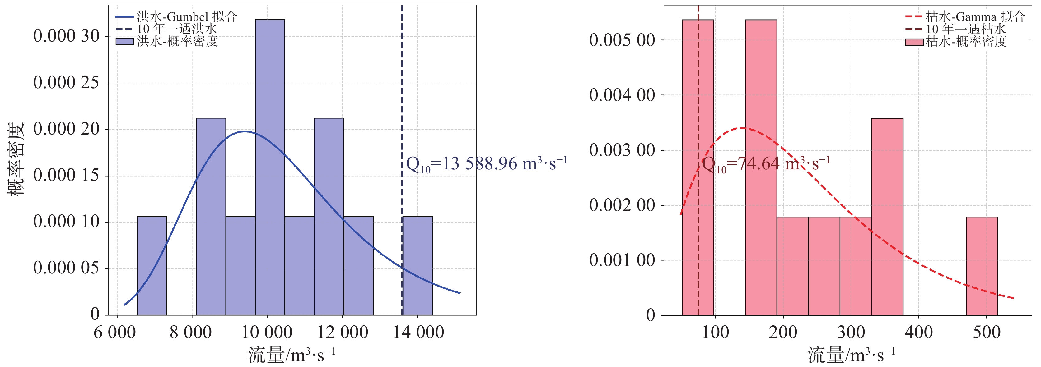
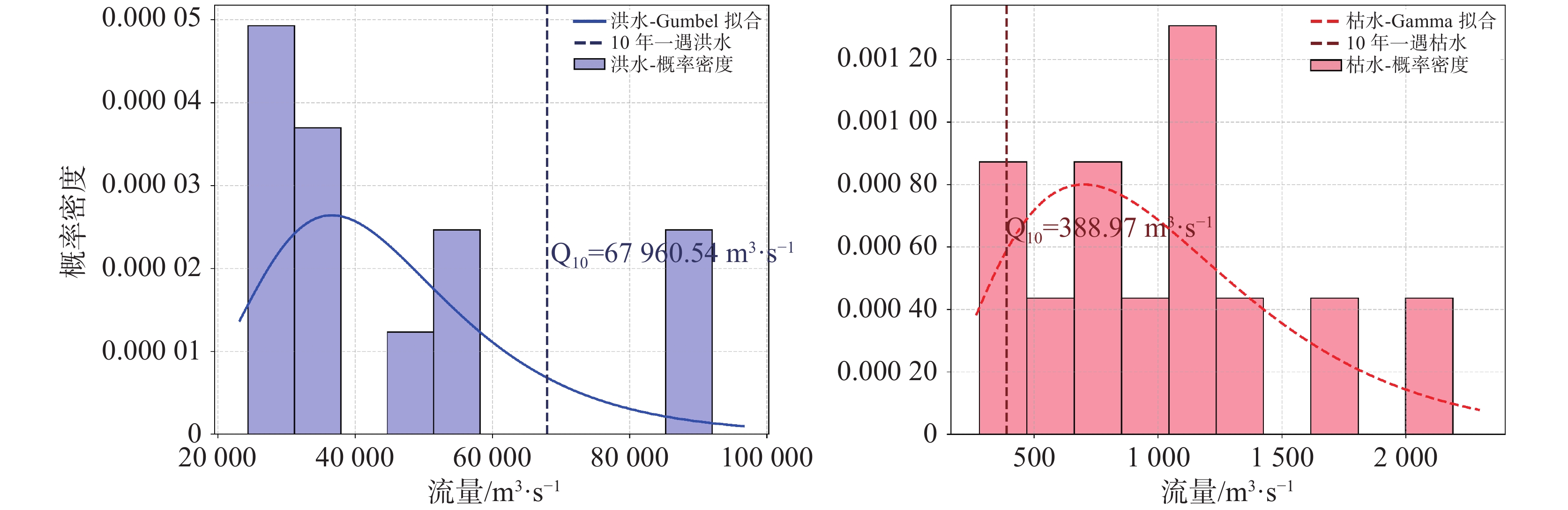
图 5 三水站洪水/枯水极值与概率密度
Figure 5. Extreme values of flood/drought flow and probability density at Sanshui station
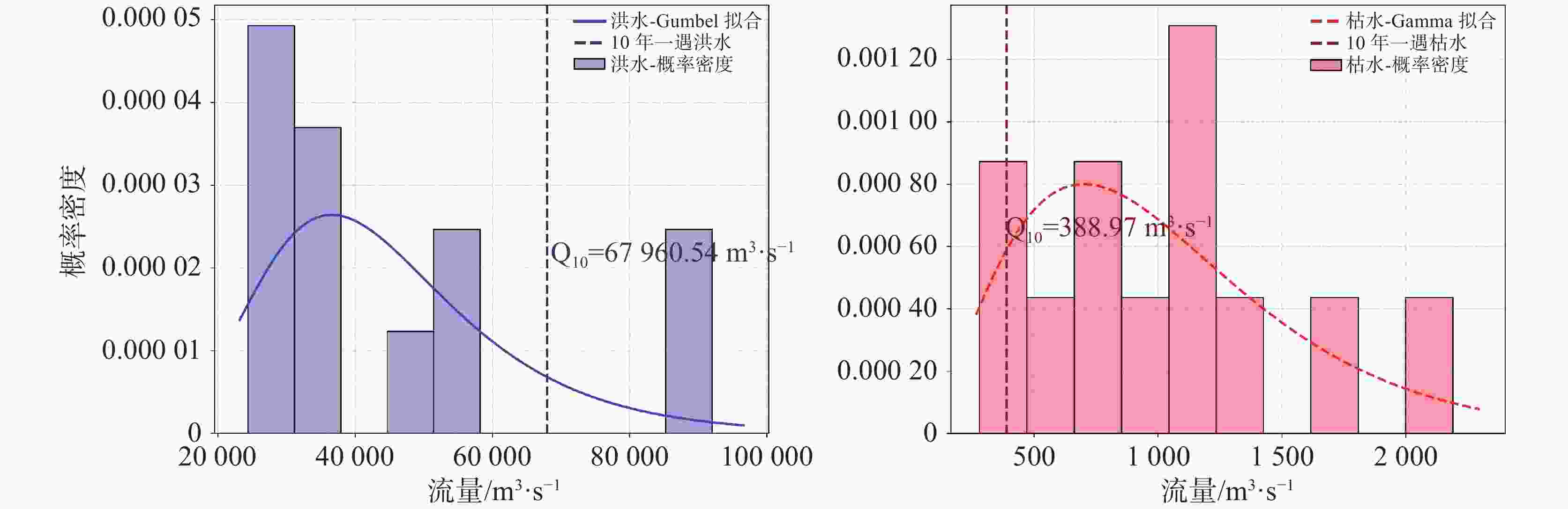
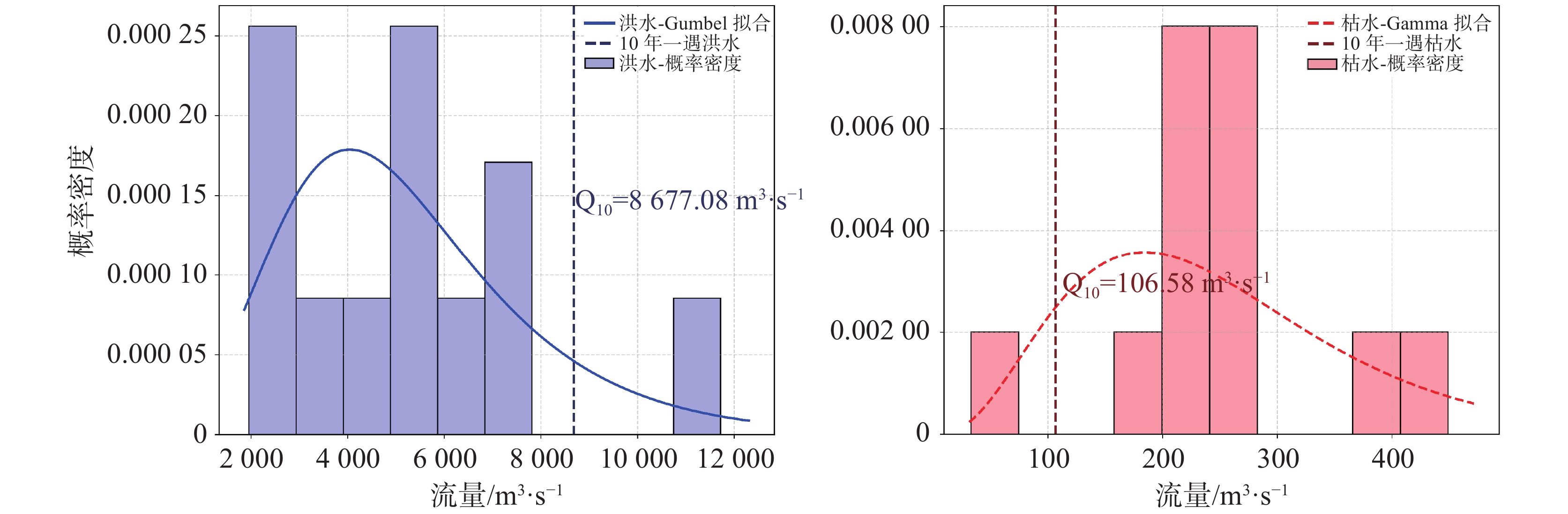
图 6 马口站洪水/枯水极值与概率密度
Figure 6. Extreme values of flood/drought flow and probability density at Makou station
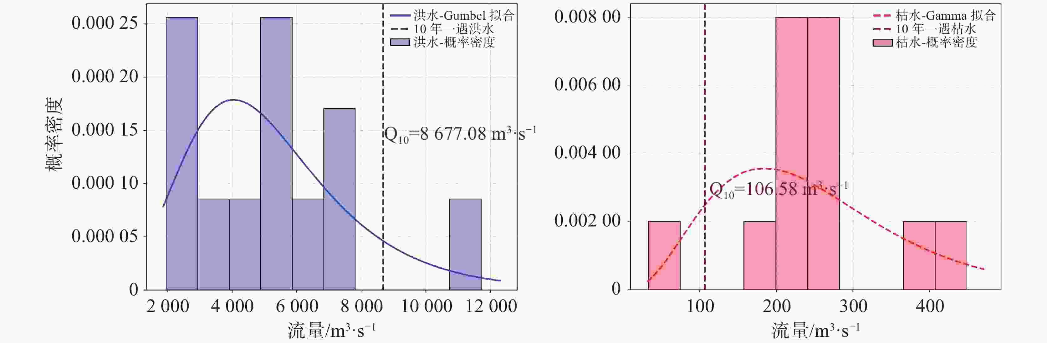
图 7 博罗站洪水/枯水极值与概率密度
Figure 7. Extreme values of flood/drought flow and probability density at Boluo station
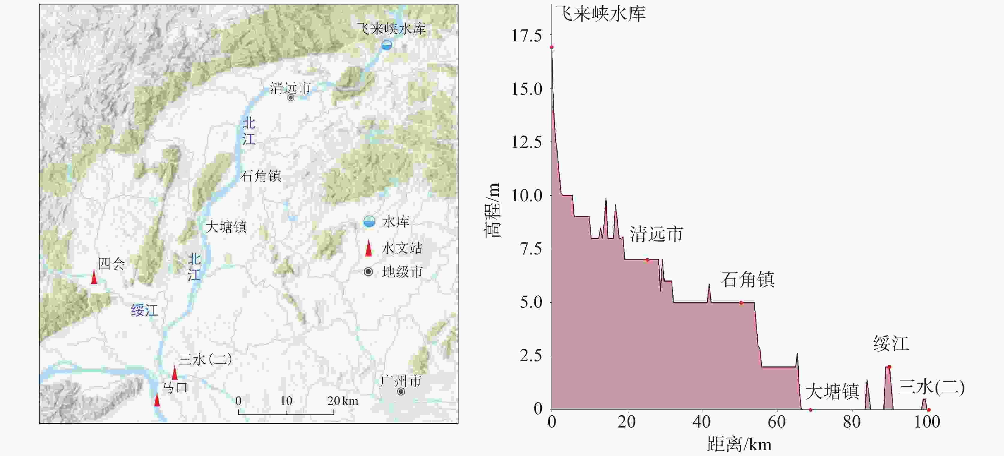
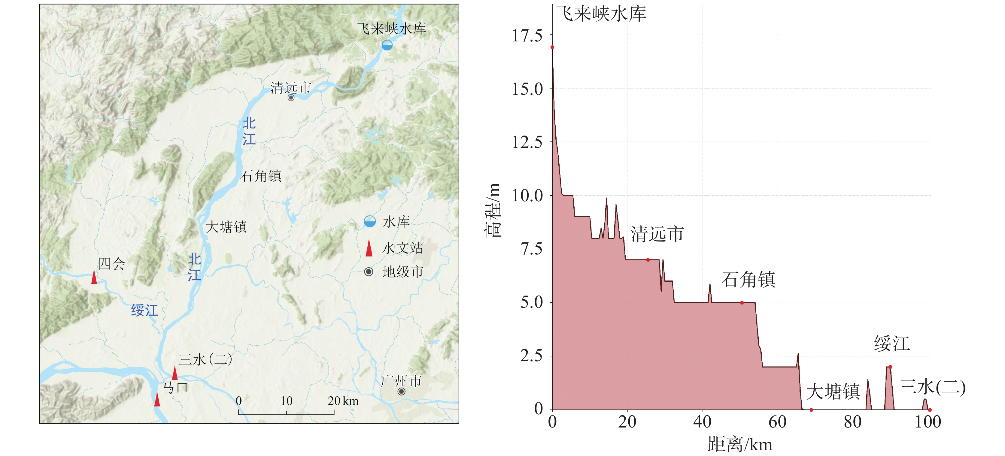
图 9 飞来峡水库与下游水文站相对位置和河道坡降
Figure 9. Relative locations of the Feilaixia reservoir and downstream hydrological stations, and riverbed slope gradient
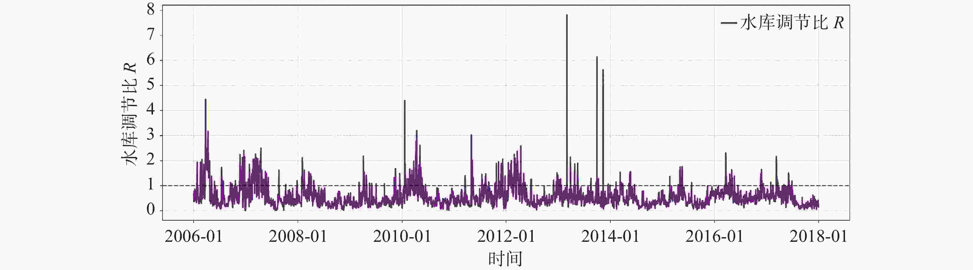
图 10 水库调节比变化特征
Figure 10. Characteristics of variations in reservoir regulation ratios
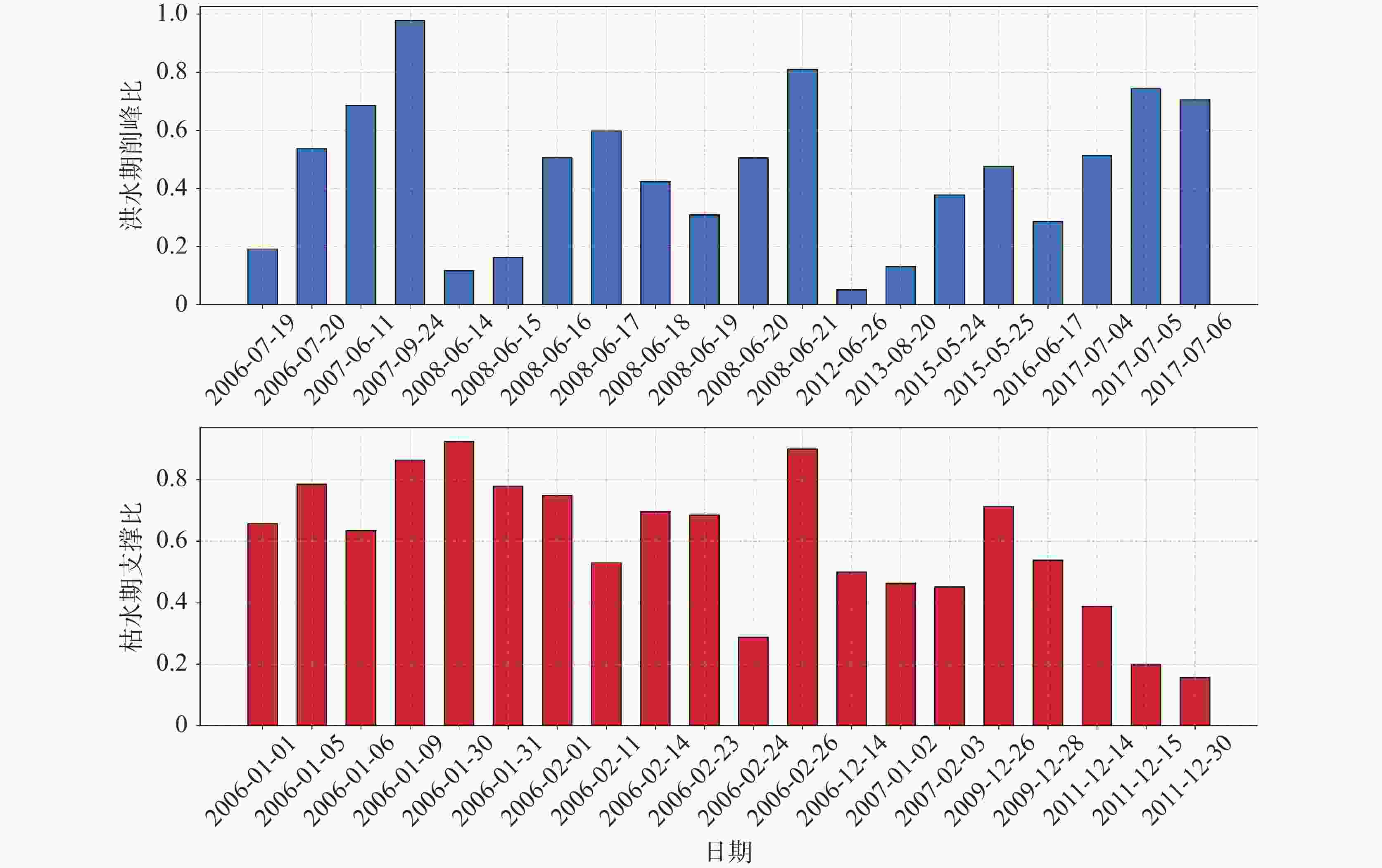
图 11 洪水削峰/枯水支撑比分布
Figure 11. Distribution of support ratios of flood peak shaving to drought
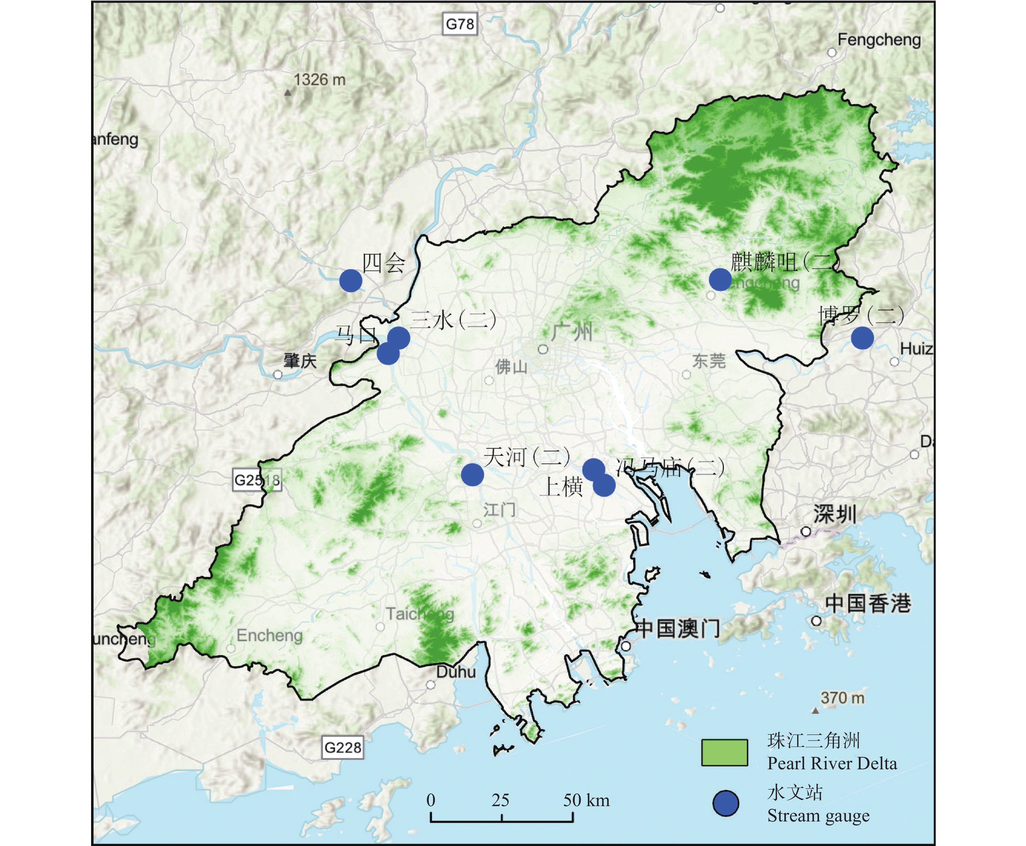
表 1 珠江三角洲水文站位置及监测时段
Table 1. Locations and monitoring periods of hydrological stations in the Pearl River Delta
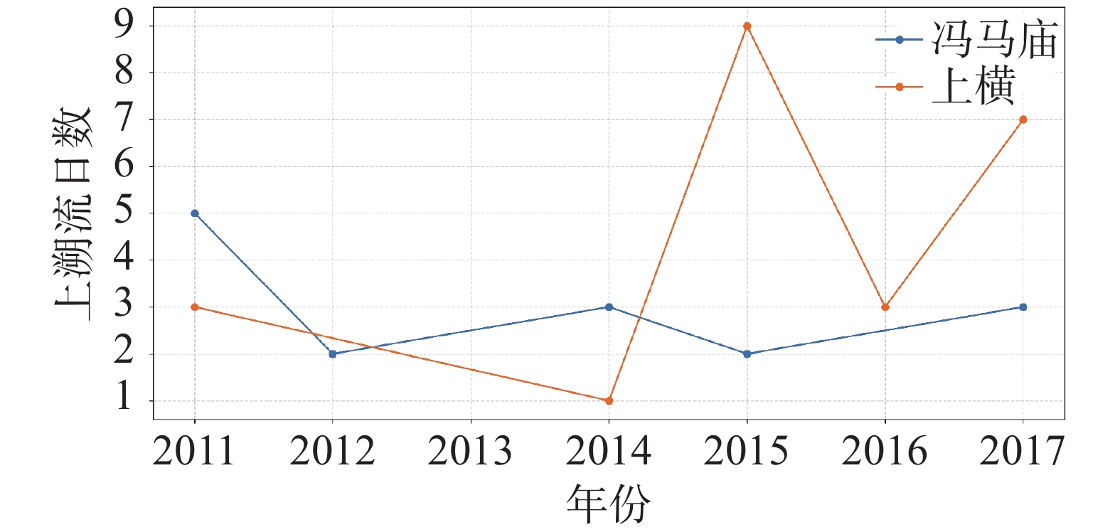
水文站名称 日流量时间段 控制水系 所属区域 珠三角上游 三水 2006-1-1至2017-12-31 北江干流 岩溶区 马口 2006-1-1至2017-12-31 西江干流 岩溶区 博罗 2006-1-1至2017-12-31 东江干流 部分岩溶区 珠三角中游 麒麟咀 2006-1-1至2017-12-31 东江北 部分岩溶区 天河 2006-1-1至2017-12-31 西海水道 非岩溶区 珠三角下游 冯马庙 2011-1-1至2017-12-31 洪奇沥水道 非岩溶区 上横 2011-1-1至2017-12-31 上横沥 非岩溶区  下载: 导出CSV
表 2 各站点M-K值检验及长期趋势
Table 2. Mann-Kendall (M-K) test results and long-term trends at each station
站点 Z值 p值 斜率 三水(北江) 16.514 0 50.254 马口(西江) 12.622 0 171.417 博罗(东江) −0.991 0.322 −8.593 麒麟咀(中游) 0.333 0.739 −1.278 天河(中游) 19.199 0 139.618
下载: 导出CSV
表 3 上游站点洪水/枯水极值与重现期
Table 3. Extreme values of flood/drought flow and return periods at upstream stations
站点 重现期/年 洪水流量/ m3∙s−1 枯水流量/ m3∙s−1 三水站 2 10084.85 198.99 三水站 5 12193.11 107.98 三水站 10 13588.96 74.64 三水站 20 14927.89 53.38 马口站 2 38461.14 840.43 马口站 5 50725.90 511.93 马口站 10 58846.23 382.24 马口站 20 66635.45 294.48 博罗站 2 4799.70 231.42 博罗站 5 7132.54 204.67 博罗站 10 8677.08 191.55 博罗站 20 10158.64 181.15
下载: 导出CSV
-
[1] Gu X, Zhang Q, Singh V P, Xiao M, Cheng J. Nonstationarity-based evaluation of flood risk in the Pearl River basin: changing patterns, causes and implications[J]. Hydrological Sciences Journal, 2016, 62(2), 246−258. [2] 郑江禹, 张强, 史培军, 顾西辉, 郑泳杰. 珠江流域多尺度极端降水时空特征及影响因子研究[J]. 地理科学, 2017, 37(2): 283-291.ZHENG Jiangyu, ZHANG Qiang, SHI Peijun, GU Xihui, ZHENG Yongjie. Spatiotemporal characteristics of extreme precipitation regimes and related driving factors in the Pearl River Basin[J]. Scientia Geographica Sinica, 2017, 37(2): 283−291. [3] 潘宗源, 吴远斌, 贾龙, 殷仁朝, 马骁, 陈婷. 湖南宁乡大成桥岩溶地下水对暴雨响应 特征及多元回归预测模型[J]. 中国岩溶, 2020, 39(2): 232-242. doi: 10.11932/karst2020y12PAN Zongyuan, WU Yuanbin, JIA Long, YIN Renchao, MA Xiao, CHEN Ting. Response characteristics of karst groundwater to rainstorm and the multiple regression prediction model in Dachengqiao, Ningxiang county, Hunan Province[J]. Carsologica Sinica, 2020, 39(2): 232-242. doi: 10.11932/karst2020y12 [4] 普政功, 黄奇波, 吴华英, 李腾芳, 邹昌霈, 廖红为. 漓江峰丛片区高位岩溶洼地洪涝水文过程及有效治理[J]. 中国岩溶, 2024, 43(4): 831-842. doi: 10.11932/karst2024y004PU Zhenggong, HUANG Qibo, WU Huaying, LI Tengfang, ZOU Changpei, LIAO Hongwei. Flood hydrological process and its effective control measures in the high-altitude depressions of peak-cluster areas in Lijiang River[J]. Carsologica Sinica, 2024, 43(4): 831-842. doi: 10.11932/karst2024y004 [5] 陈子燊. 珠江流域干旱时空变化的经验诊断分析[J]. 中山大学学报 (自然科学版), 2020, 59(4): 33-42.CHEN Zishen. Empirical diagnostic analysis on spatial and temporal variations of droughts in the Pearl River Basin, China[J]. Journal of Sun Yat-sen University (Natural Science Edition), 2020, 59(4): 33-42. [6] Wang X, Guo Y, Ren J. The coupling effect of flood discharge and storm surge on extreme flood stages: A case study in the Pearl River Delta, South China[J]. International Journal of Disaster Risk Science, 2021, 12(4): 1-15. [7] Zhou Z, Shi H, Fu Q, Ding Y, Li Y, Wang Y, Liu S. Characteristics of propagation from meteorological drought to hydrological drought in the Pearl River Basin[J]. Journal of Geophysical Research: Atmospheres, 2021, 126(4): e2020JD033959. doi: 10.1029/2020JD033959 [8] Du H, Fei K, Gao L. Nonlinear tide-river-surge interactions and their impacts on compound flooding during typhoon Hato in the Pearl River Delta[J]. Journal of Geophysical Research: Oceans, 2024, 129(11): e2023JC020673. doi: 10.1029/2023JC020673 [9] 郭婷, 张蔚, 季小梅, 季小梅, 徐龑文, 罗小雅. 珠江三角洲风暴潮与径流作用下的复合洪水特征[J]. 地理科学进展, 2023, 42(6): 1162-1171. doi: 10.18306/dlkxjz.2023.06.011GUO Ting, ZHANG Wei, JI Xiaomei, XU Yanwen, LUO Xiaoya. Compound flood from storm surge and runoff in the Pearl River Delta[J]. Progress in Geography, 2023, 42(6): 1162-1171. doi: 10.18306/dlkxjz.2023.06.011 [10] Qiang Y, Zhang L, He J, Xiao T, Huang H, Wang H. Urban flood analysis for Pearl River Delta cities using an equivalent drainage method upon combined rainfall-high tide-storm surge events[J]. Journal of Hydrology, 2021, 597: 126293. doi: 10.1016/j.jhydrol.2021.126293 [11] Luo X L, Zeng E Y, Ji R Y, Wang C P. Effects of in-channel sand excavation on the hydrology of the Pearl River Delta, China[J]. Journal of Hydrology, 2007, 343(3-4): 230-239. doi: 10.1016/j.jhydrol.2007.06.019 [12] Gong W, Lin Z, Chen Y, Chen Z, Zhang H. Effect of winds and waves on salt intrusion in the Pearl River estuary[J]. Ocean Science, 2018, 14(1): 139-159. doi: 10.5194/os-14-139-2018 [13] He Y, Liu X, Duan Z, Liu C, Hou P, Lu C, Wu Y. Long-term morphodynamic evolution in the modaomen estuary of the pearl river delta, south China[J]. Geomorphology, 2022, 398: 108057. doi: 10.1016/j.geomorph.2021.108057 [14] Yuan R, Zhu J. The effects of dredging on tidal range and saltwater intrusion in the Pearl River estuary[J]. Journal of Coastal Research, 2015, 31(6): 1357−1362. [15] 杨夏玲, 黎树式, 许珊珊, 虞崇熙, 潘洁. 近60年来极端天气影响下南流江入海水沙变化[J]. 热带海洋学报, 2023, 42(4): 91-103.YANG Xialing, LI Shushi, XU Shanshan, YU Chongxi, PAN Jie, Variations in water and sediments of the Nanliu River flowing into the sea under the influence of extreme weather in the past 60 years[J]. Journal of Tropical Oceanography, 2023, 42(4): 91-103. [16] 宋晓猛, 徐楠涛, 张建云, 贺瑞敏. 中国城市洪涝问题: 现状、成因与挑战[J]. 水科学进展, 2024, 35(3): 357-373.SONG Xiaomeng, XU Nantao, ZHANG Jianyun, HE Ruimin. Urban flooding in China: current status, causes and challenges[J]. Advance in Water Science, 2024, 35(3): 357-373. [17] Zhang Q, Xiao M, Liu C L, Singh V P. Reservoir-induced hydrological alterations and environmental flow variation in the East River, the Pearl River basin, China[J]. Stochastic environmental research and risk assessment, 2014, 28: 2119-2131. doi: 10.1007/s00477-014-0893-4 [18] Zhang W, Wei X, Zheng J, Zhu Y, Zhang Y. Estimating suspended sediment loads in the Pearl River Delta region using sediment rating curves[J]. Continental Shelf Research, 2012, 38: 35-46. doi: 10.1016/j.csr.2012.02.017 [19] Wei X, Cai S, Zhan W. Impact of anthropogenic activities on morphological and deposition flux changes in the Pearl River Estuary, China[J]. Scientific Reports, 2021, 11(1): 16643. doi: 10.1038/s41598-021-96183-0 [20] 何治波. 近 20 年珠江枯水期 “压咸补淡” 应急水量调度形势、策略与启示[J]. 中国防汛抗旱, 2024, 34(11): 6-10, 22.HE Zhibo. Situation, strategy and enlightenment of emergency water regulation of suppressing saltwater and replenishing freshwater in the Pearl River during the dry seasons in recent 20 years[J]. China Flood & Drought Management, 2024, 34(11): 6-10, 22. [21] Yan D, Werners S E, Huang H Q, Ludwig F. Identifying and assessing robust water allocation plans for deltas under climate change[J]. Water resources management, 2016, 30: 5421-5435. doi: 10.1007/s11269-016-1498-0 [22] Tang Y, Xi S, Chen X, Lian Y. Quantification of multiple climate change and human activity impact factors on flood regimes in the Pearl River Delta of China[J]. Advances in Meteorology, 2016, 2016(1): 3928920. [23] Chen Y D, Zhang Q, Yang T, Xu C, Chen X, Jiang T. Behaviors of extreme water level in the Pearl River Delta and possible impacts from human activities[J]. Hydrology and Earth System Sciences Discussions, 2007, 4(6): 4361-4387. [24] Zhang Q, Gu X, Singh V P, Shi P, Sun P. More frequent flooding? Changes in flood frequency in the Pearl River basin, China, since 1951 and over the past 1000 years[J]. Hydrology and Earth System Sciences, 2018, 22(5): 2637-2653. doi: 10.5194/hess-22-2637-2018 [25] Zhang Q, Xu C Y, David Chen Y. Variability of water levels and impacts of streamflow changes and human activity within the Pearl River Delta, China[J]. Hydrological Sciences Journal−Journal des Sciences Hydrologiques, 2010, 55(4): 512-525. doi: 10.1080/02626667.2010.481372 [26] 梁曼琳, 刘丙军, 李旦. 珠江流域旱涝急转事件识别指数优选研究[J]. 自然灾害学报, 2022, 31(4): 57-64.LIANG Manlin, LIU Bingjun, LI Dan. Optimization of identification index for drought-flood abrupt alternation events in the Pearl River Basin[J]. Journal of Natural Disasters, 2022, 31(4): 57-64. [27] 范敏韬, 佘贞燕, 余龙飞, 陈晓宏, 刘智勇. 珠江三角洲河网区极端水位事件风险传递规律[J]. 水资源保护, 2024, 40(2): 81-89. doi: 10.3880/j.issn.1004-6933.2024.02.011FAN Mintao, SHE Zhenyan, YU Longfei, CHEN Xiaohong, LIU Zhiyong. Risk transfer law of extreme water level events in river network area of the Pearl River Delta[J]. Water Resources Protection, 2024, 40(2): 81-89. doi: 10.3880/j.issn.1004-6933.2024.02.011 [28] 张卡, 刘丙军, 胡仕焜, 曾慧, 张明珠, 李丹. 珠江河口区复合洪水事件多要素非一致性的时变遭遇分析[J]. 热带地理, 2024, 44(1): 143-151.ZHANG Ka, LIU Bingjun, HU Shikun, ZENG Hui, ZHANG Mingzhu, LI Dan. Multi-element non-coherent time-varying encounter analysis of complex hazards contributing to Pearl River estuary flooding[J]. Tropical Geography, 2024, 44 (1): 143-151. [29] 邹华志, 唐琦, 张艳艳, 林中源. 珠江河口地形变化对咸潮上溯影响的定量化研究[J]. 中国防汛抗旱, 2024, 34(11): 56-61.ZOU Huazhi, TANG Qi, ZHANG Yanyan, LIN Zhongyuan. Quantitative study on the effect of topographic changes on the saltwater intrusion in the Pearl River Estuary[J]. China Flood & Drought Management, 2024, 34(11): 56-61. [30] 刘文冲, 赵良杰, 崔亚莉, 曹建文, 王莹, 李美玲. 基于SWAT-MODFLOW 地表−地下水耦合模型的结构与应用研究[J]. 中国岩溶, 2023, 42(6): 1131-1139. doi: 10.11932/karst2023y014LIU Wenchong, ZHAO Liangjie, CUI Yali, CAO Jianwen, WAGN Ying, LI Meiling. Structure and application of SWAT-MODFLOW coupling model for surface-groundwater[J]. Carsologica Sinica, 2023, 42(6): 1131-1139. doi: 10.11932/karst2023y014 [31] 徐子凡, 陈喜, 刘维翰, 刘皓, 张志才. 表层岩溶带土岩结构对降雨−径流响应特征的影响[J]. 中国岩溶, 2024, 43(4): 863-875. doi: 10.11932/karst20240406XU Zifan, CHEN Xi, LIU Weihan, LIU Hao, ZHANG Zhicai. Effect of soil-rock structures on the characteristics of rainfall-runoff responses in epikarst zones[J]. Carsologica Sinica, 2024, 43(4): 863-875. doi: 10.11932/karst20240406 -


 点击查看大图
计量
- 文章访问数: 1194
- HTML浏览量: 785
- PDF下载量: 17
- 被引次数: 0
