

Study on the characteristics of interannual dynamic variations in groundwater levels in the Dianchi lake basin
-
摘要: 随着社会经济的不断发展,1980—2020年间城市面积不断扩大,滇池流域即昆明盆地的城市地下工程越来越密集,工业用水量增加,地方政府对地下水资源加强管理,地下水位呈现出了不同的变化特征。文章依托上世纪80年代、2006年以及2020年现有监测井的水位监测数据统计,采取统计法、对比法,利用Arcgis绘制了不同时期昆明盆地地下水位等值线图,以此来分析昆明盆地近40年来的水位变化、引起水位变化的原因以及水位变化可能会引发的环境地质问题,得出近40年以来昆明盆地地下水位整体呈现上升趋势。自2008—2009年大范围封停地下水井后,盆地大部分地区地下水位均在2009年后呈现明显上升的态势,局部地区由于工业用水量较大等原因使地下水位依然呈现出下降趋势。Abstract:
Between 1980 and 2020, with the continuous development of the social economy and the expansion of urban areas, the urban underground engineering in the Dianchi lake basin, also known as the Kunming basin, became increasingly dense. Industrial water consumption increased, and the government strengthened its management of groundwater resources, resulting in variations in groundwater levels. The demand for water resources continued to increase, but the problem of water pollution remained severe. Under the premise that some surface water bodies and pore water have been polluted by human activities, deep well drilling became a common way to extract groundwater at that time. However, with the increasing number of deep wells, the overall groundwater levels of the entire basin were affected, and problems such as the drying up of spring water, falling funnels, and ground collapses occurred in succession. This study is based on the statistical analysis of water level monitoring data collected from existing monitoring wells in the 1980s, 2006, and 2020. With statistical and comparative methods, ArcGIS was used to create contour maps of groundwater levels and maps of water level variations in the Kunming basin over various periods. Based on the principles of hydrogeology, environmental geology, and groundwater system analysis, this study identified the main natural and human influencing factors, effects of controlling groundwater resources and environment, and the existing challenges. It analyzed and summarized the variations in water levels in the Kunming basin over the past 40 years. Additionally, this study outlined the reasons for these water level fluctuations and the potential problems of environmental geology that may arise as a result. Analyses indicate that groundwater levels in the Kunming basin have shown an overall upward trend over the past 40 years. From the 1960s to the 1980s, fluctuations in groundwater levels in the Kunming basin were not significant, although the overall situation indicated a decline. Besides, and the extraction of groundwater and its rate of increase were relatively modest. From the 1980s to 2006, the groundwater levels in the Kunming basin showed a downward trend, especially in the areas of Dounan flower market in Chenggong district, as well as Paomashan and Jinma temple in Guandu district, where the water levels experienced a notable decrease. From 2006 to 2020, overall groundwater levels showed an upward trend, with significant increases observed in the area of Cuihu and the area of Majie printing and dyeing factory in Xishan district, which was classified as a zone of strong upward trends. However, most areas were characterized as the zones where the water levels experienced slight rises, including the area of Dounan flower market in Chenggong district, as well as the areas of Paomashan and Jinma temple in Guandu district. In these areas, the groundwater levels were relatively stable, with a fluctuation of about +1 m in 2020 compared to 2006. The water levels observed in the area of heavy machinery factory in Panlong district indicated a significantly downward trend. After the large-scale closure of underground water wells from 2008 to 2009, the groundwater levels in most areas of the basin showed a significant upward trend after 2009, while in some areas, due to large industrial water consumption and other reasons, the water levels still showed a downward trend. At present, the changes in the low water level center of the basin are closely related to human activities. With the development of the social economy, the changes in the low water level center are no longer only biased towards excessive exploitation of industrial, agricultural, and domestic water. The construction of a large number of civil defense projects and underground transportation projects in the urban area requires a large amount of drainage in the early stages of construction, resulting in a decrease in the surrounding groundwater levels. The decrease in groundwater levels causes changes in hydrodynamic conditions, accelerating the circulation and alternation between surface water, pore water, and bedrock water, leading to the continuous concentration of nearby sewage in the funnel area and promoting groundwater pollution. The overall decline in the water level of the aquifer may also lead to the lateral replenishment of groundwater by polluted rivers, resulting in contamination of the aquifer. For example, the Mayuan river, the Liangjia river, the Xibian river, the Panlong river, and the Jinzhi river collect industrial wastewater and domestic sewage from the west and east of the city. The decline in groundwater levels on both sides of the river will cause groundwater pollution. Today, the groundwater flow field in the Kunming basin has become a natural and artificial compound flow field. The water level dynamics under the influence of meteorological cycles are significantly affected by human factors. The change and amplitude of water level rise and fall are synchronized with the increase and decrease of groundwater mining output, excavation and drainage of underground space, etc. The projects of cross-flow diversion and water diversion have alleviated the decline of groundwater levels to a certain extent. With the popularization of knowledge related to groundwater, the government and the people gradually understand the environmental geological problems that excessive exploitation of groundwater resources may bring, and hence taking corresponding corrective measures. -
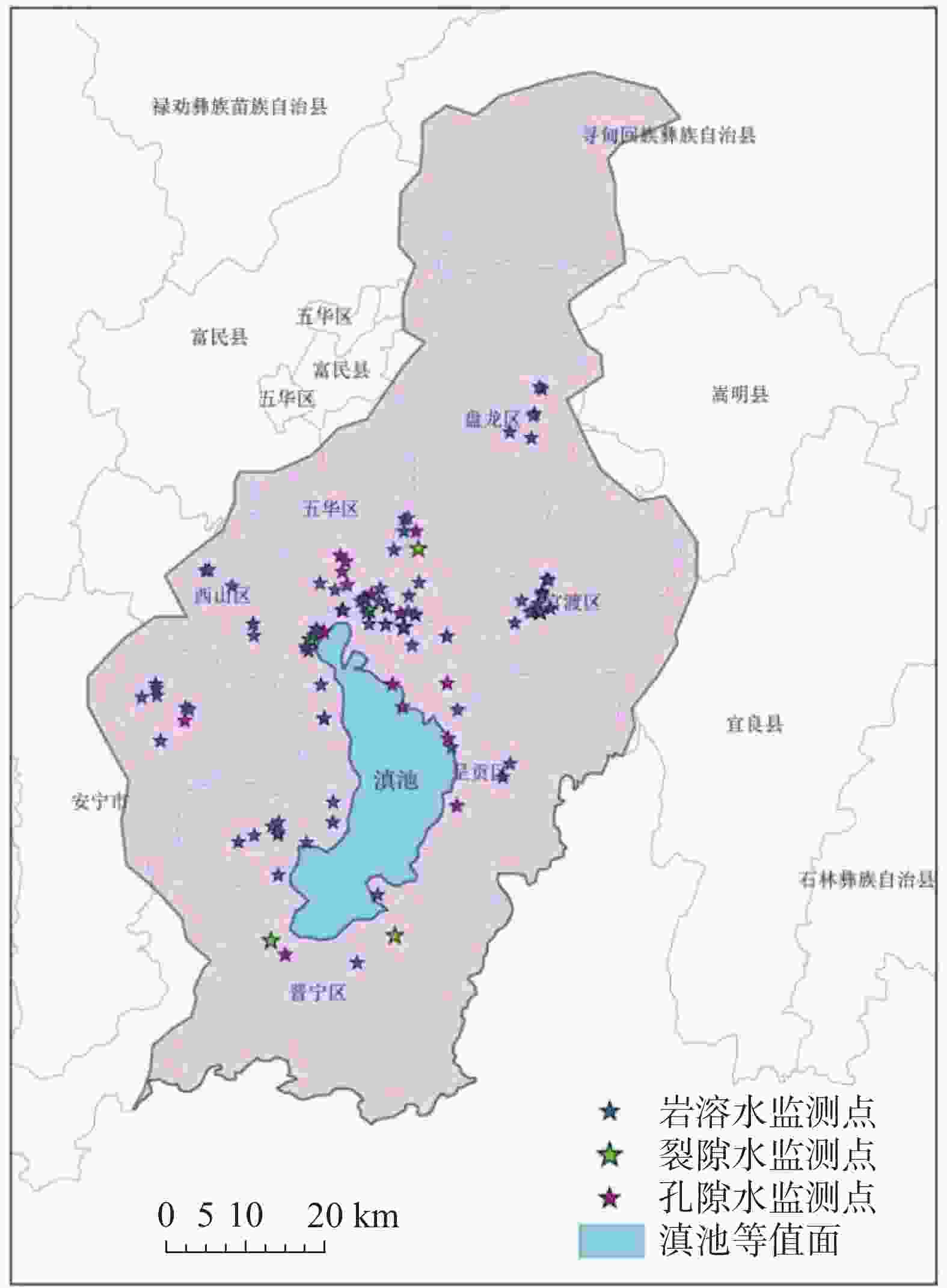
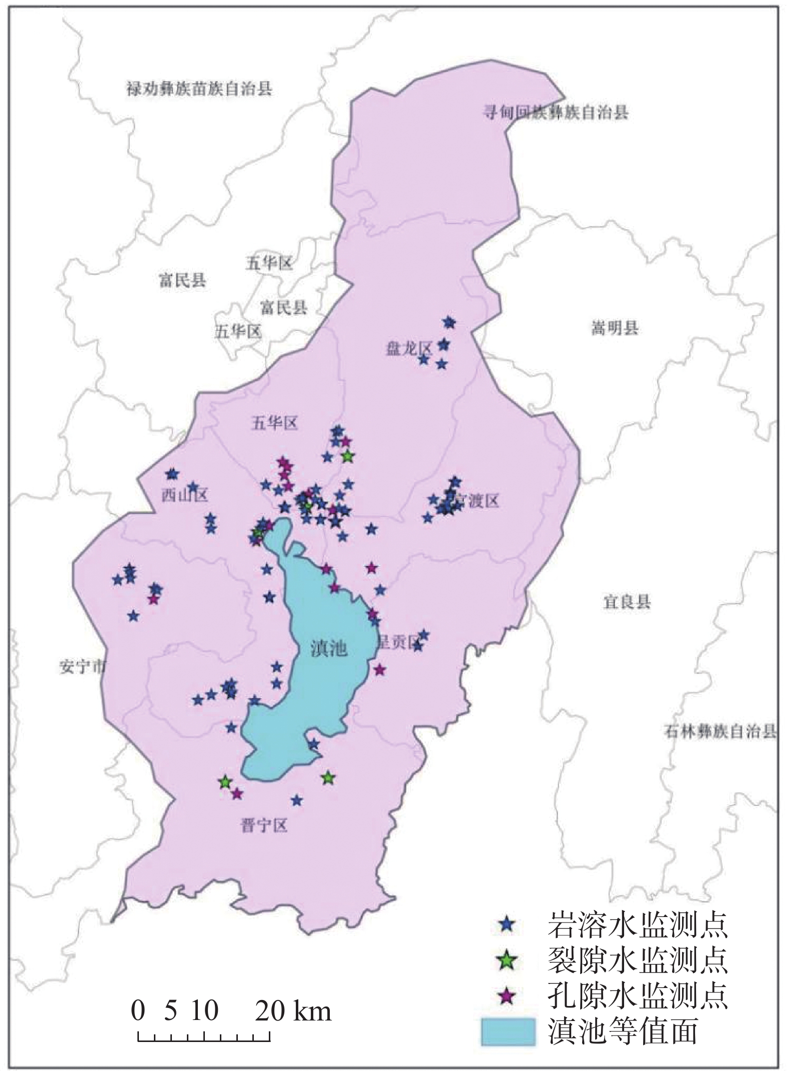
图 1 昆明盆地地下水监测点分布图
Figure 1. Distribution of groundwater monitoring points in the Kunming basin
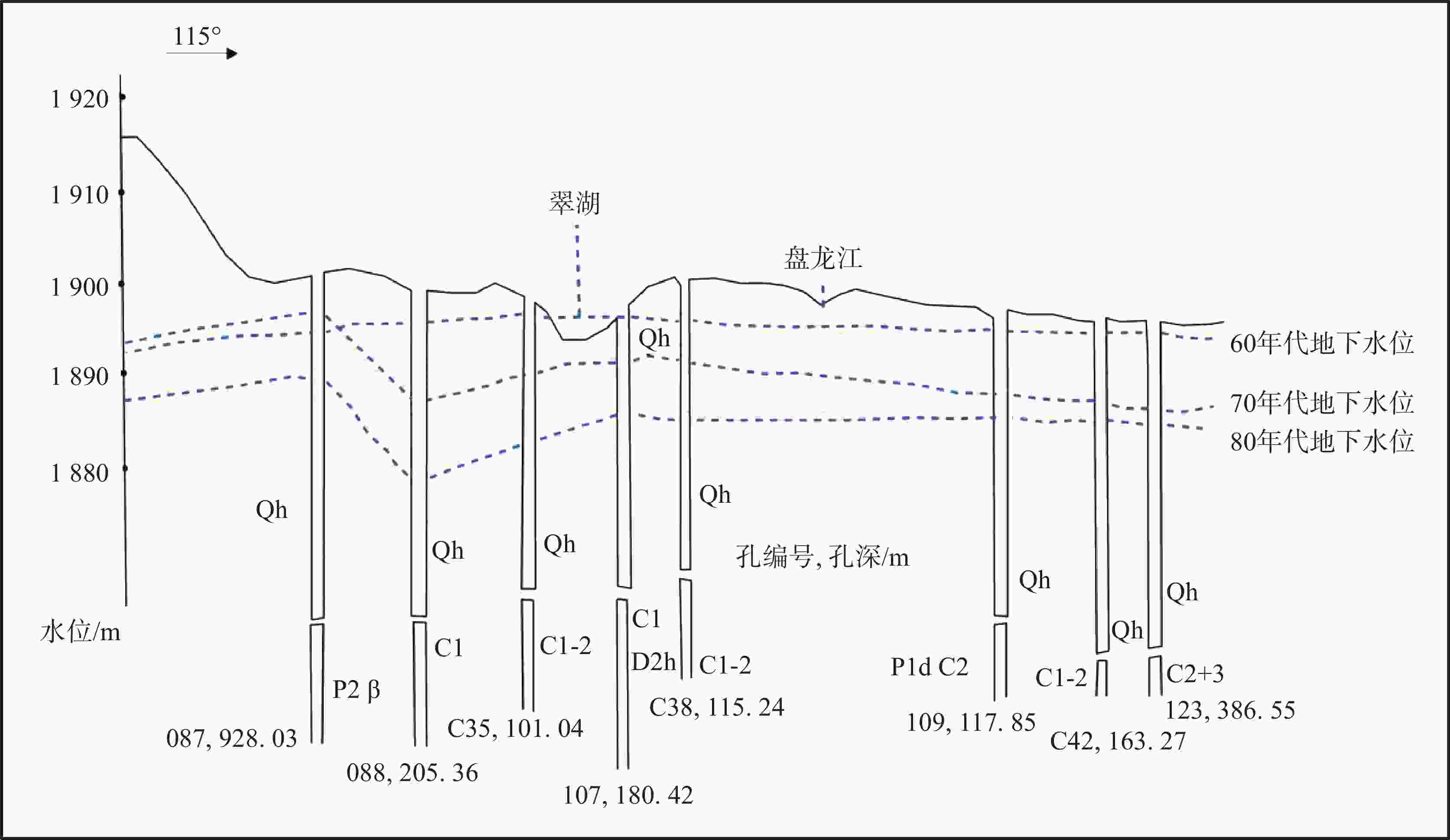
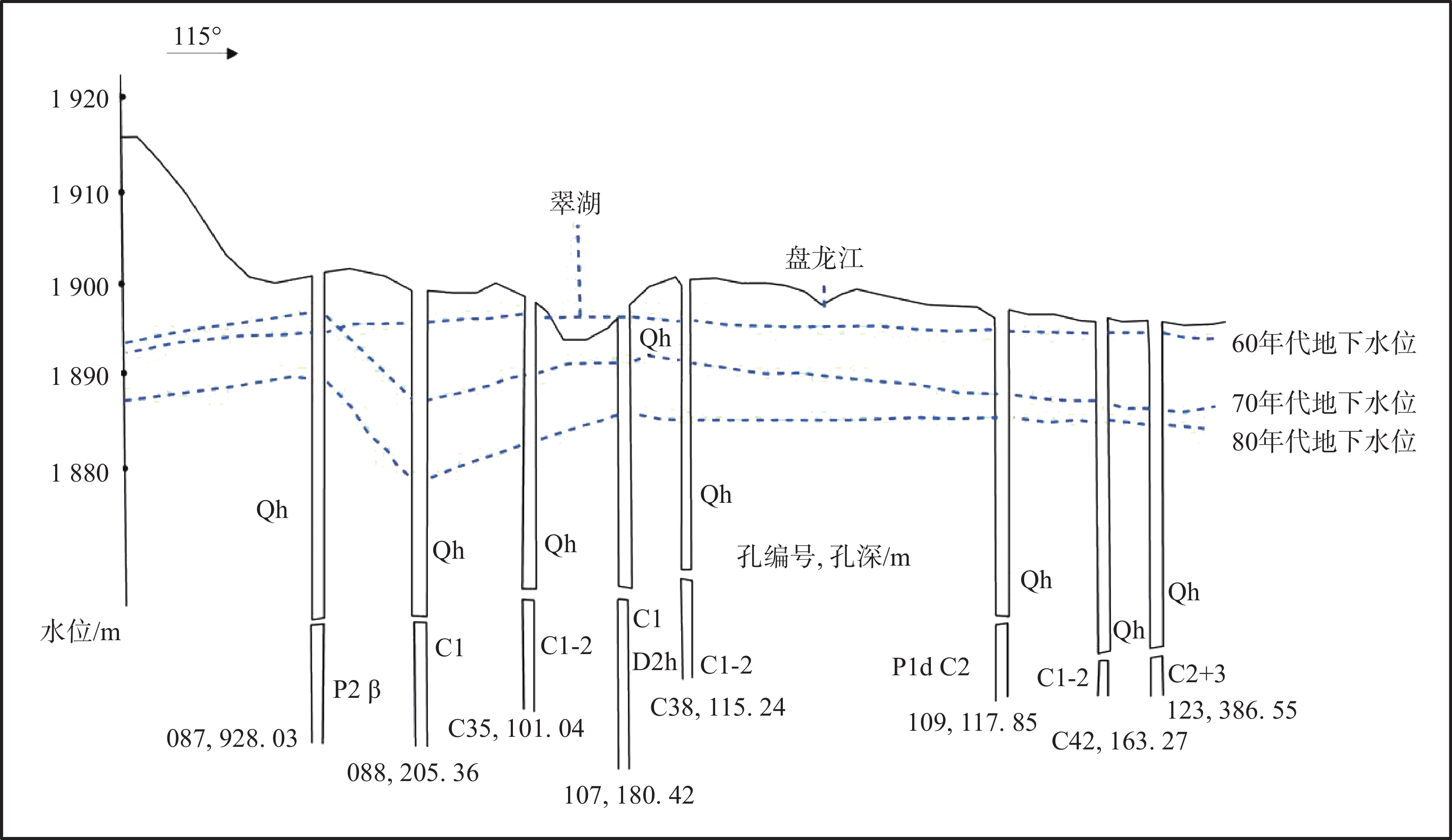
图 2 昆明盆地20世纪60-80年代地下水位变化曲线图
Figure 2. Variation curves of groundwater levels in the Kunming basin from 1960s to 1980s
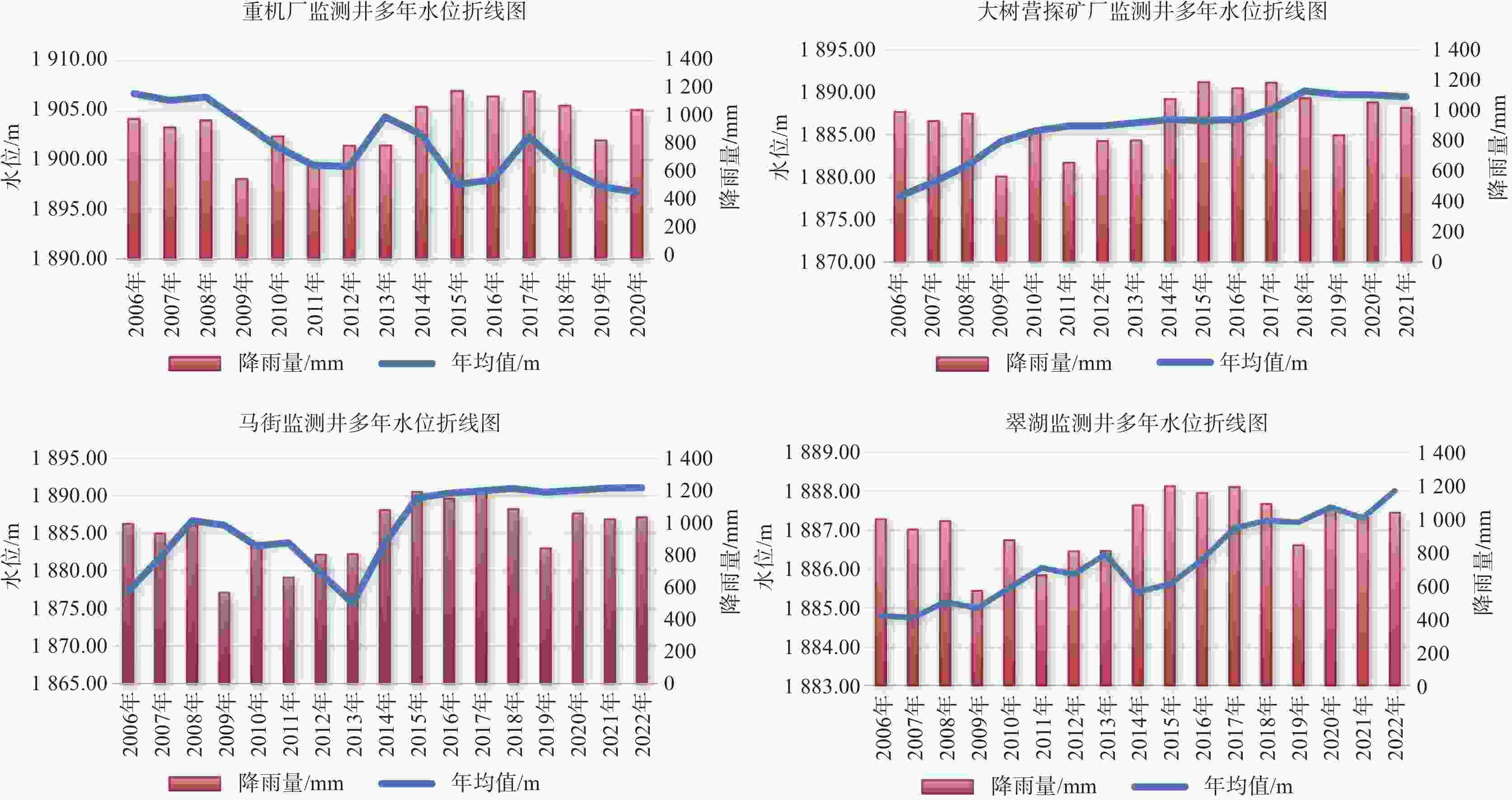
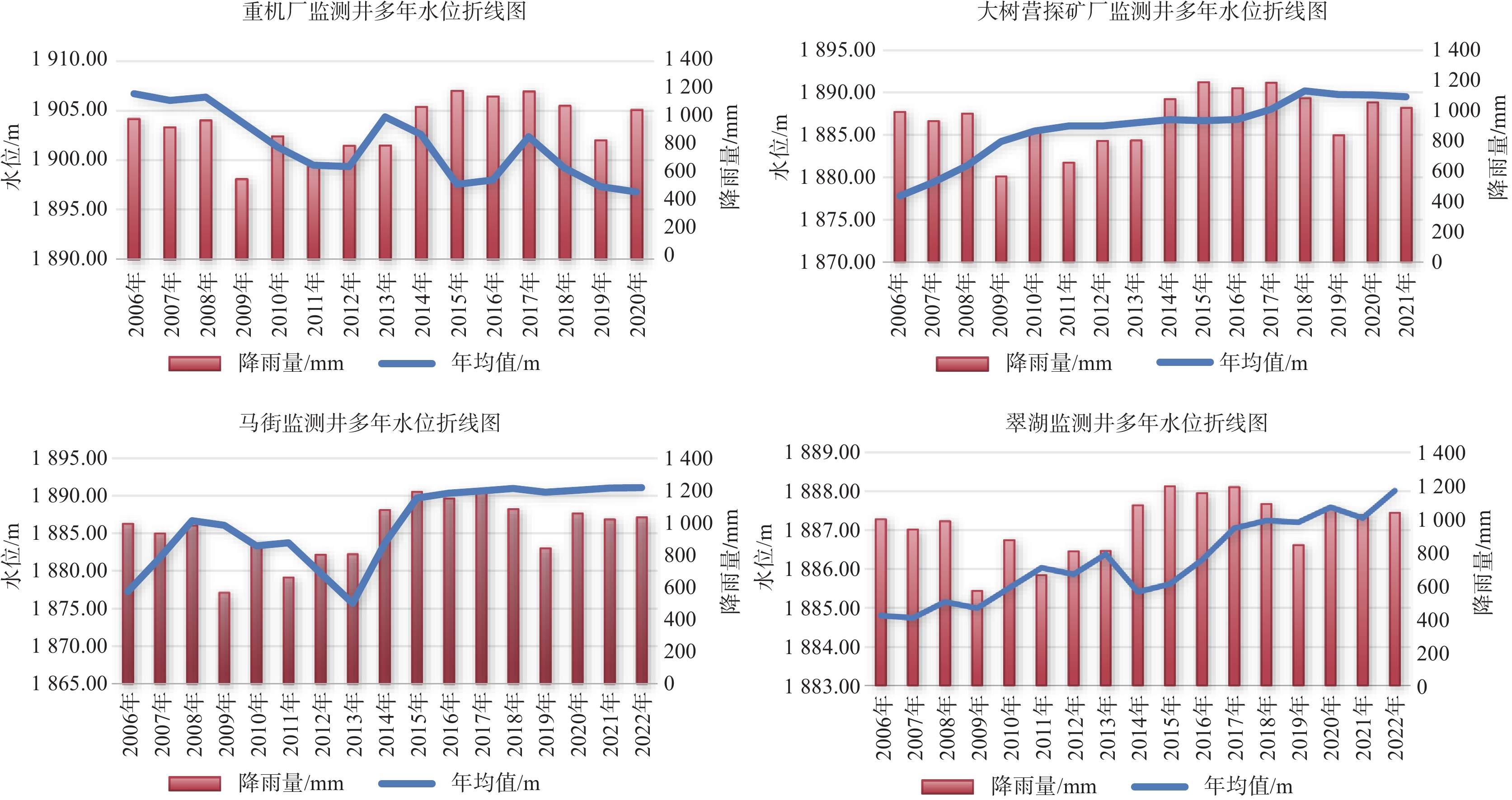
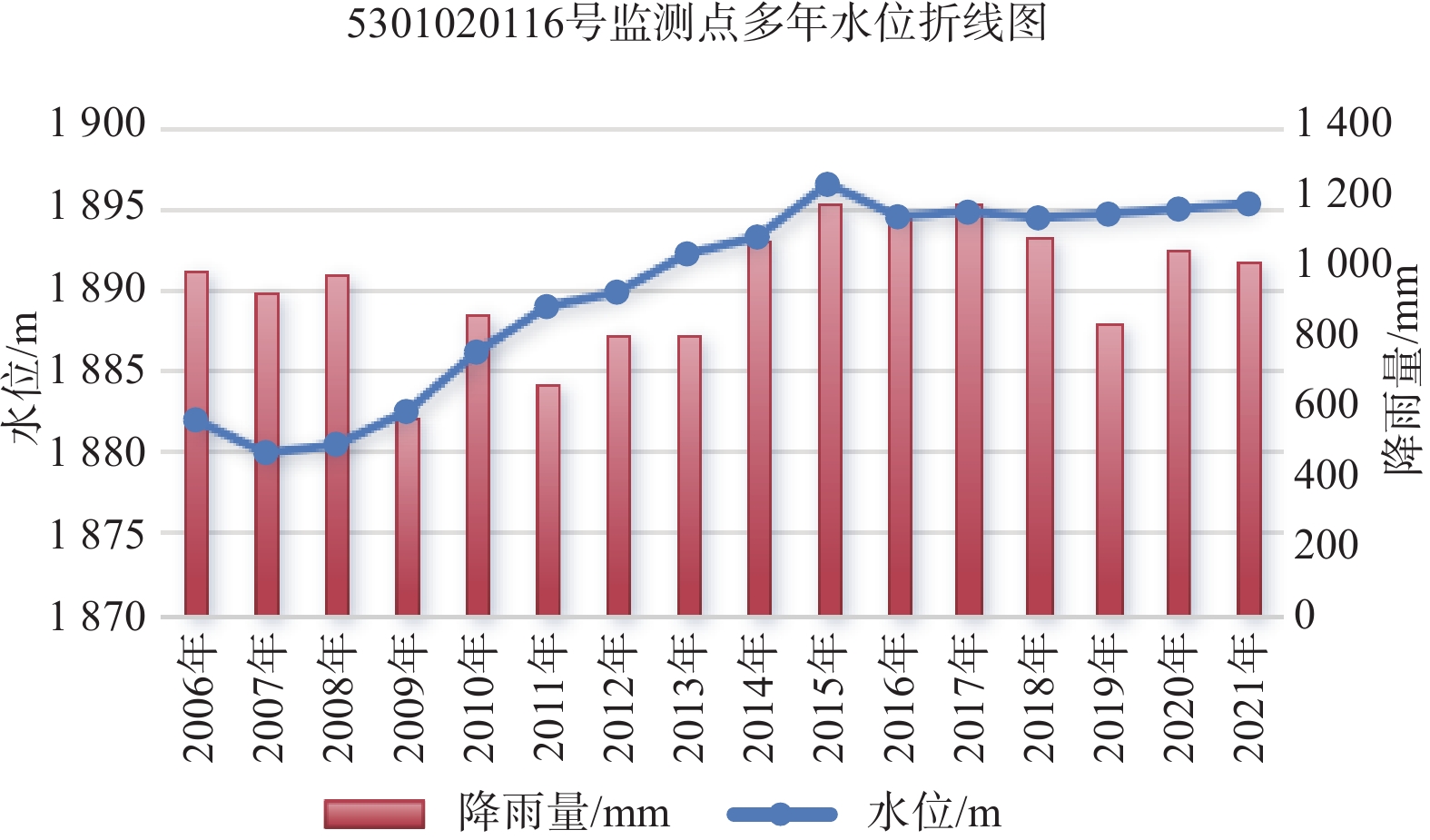
图 3 典型监测点多年水位折线图
Figure 3. Line chart of multi-year water levels at typical monitoring points
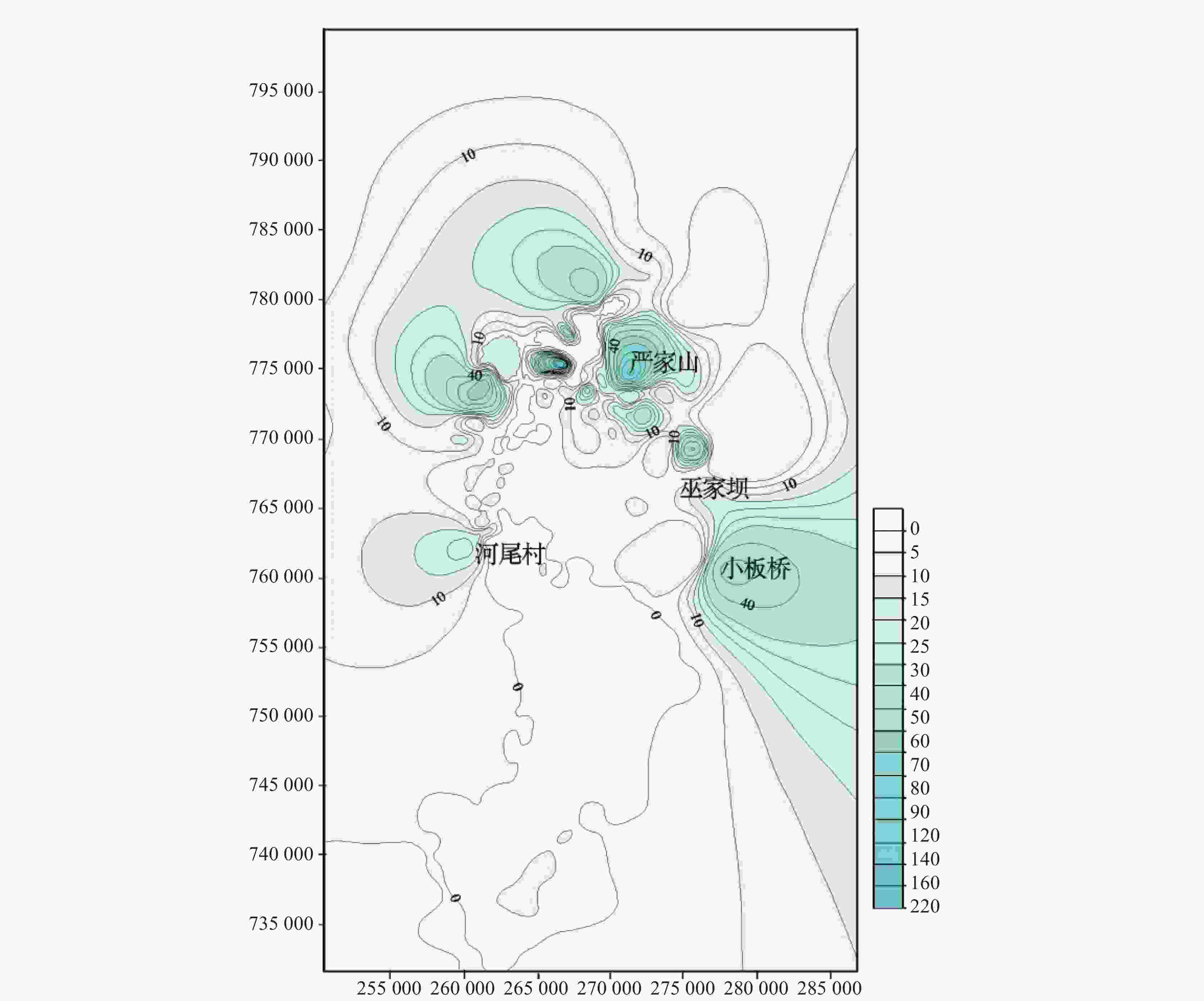
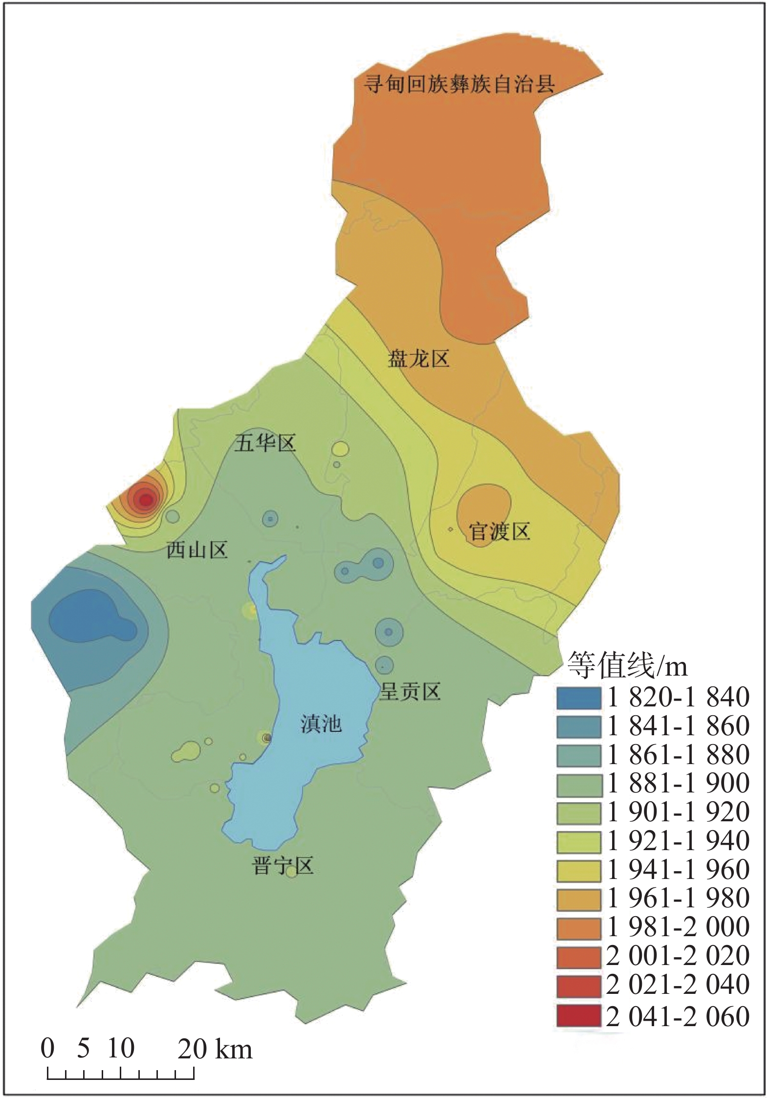
图 4 1984年昆明盆地基岩水等水位线图
Figure 4. Contour map of bedrock water level in the Kunming basin in 1984
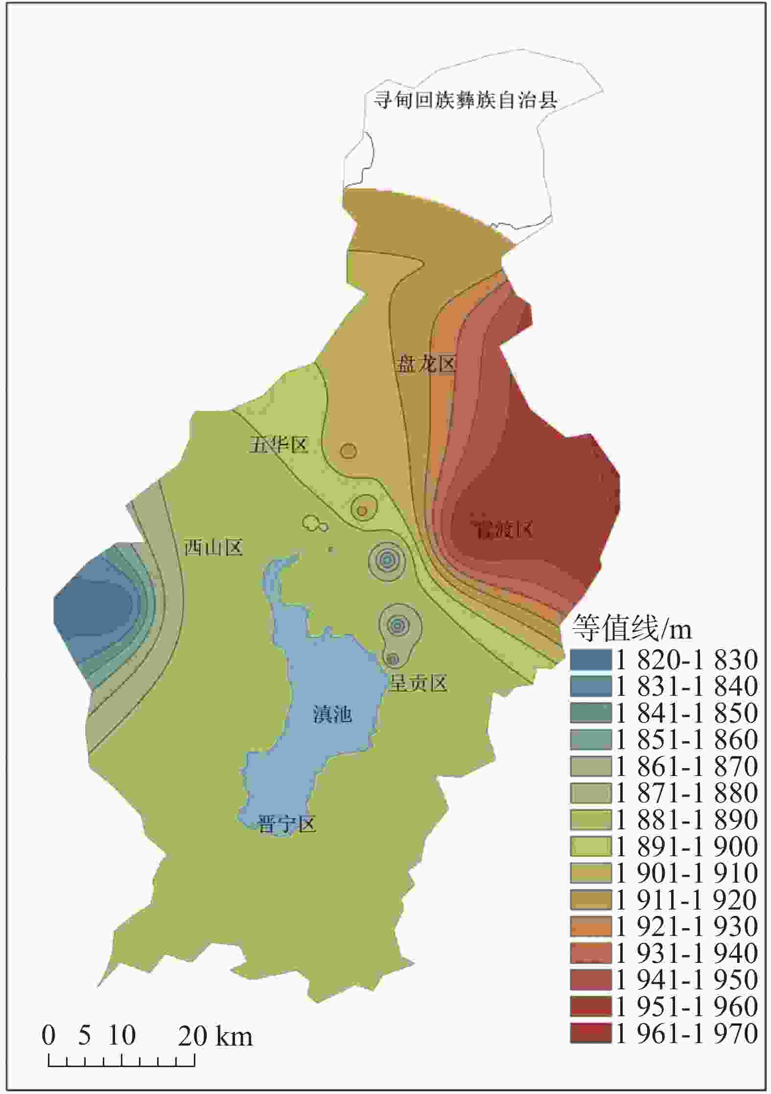
图 5 2006年昆明盆地基岩水等水位线图
Figure 5. Contour map of bedrock water level in the Kunming basin in 2006
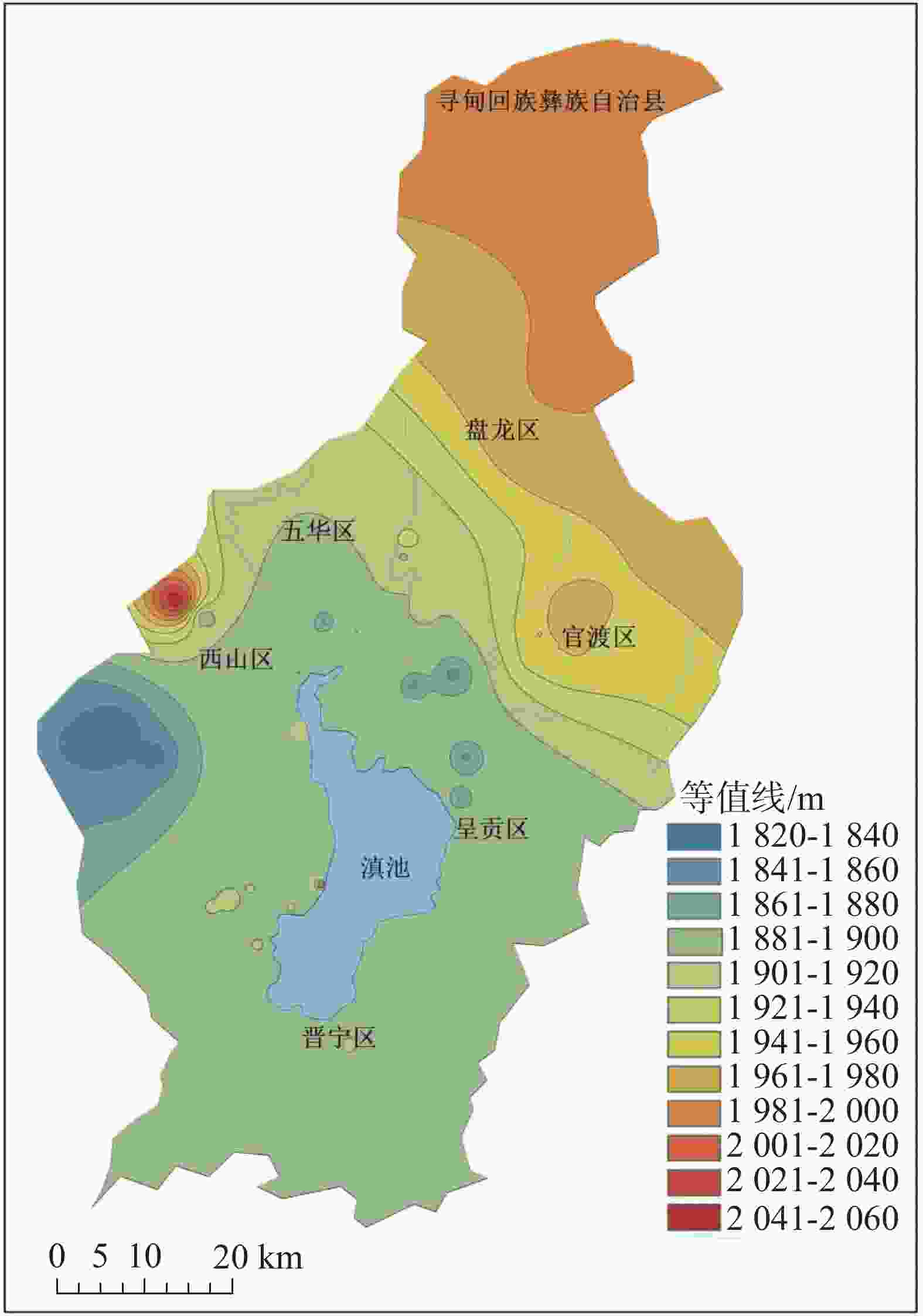
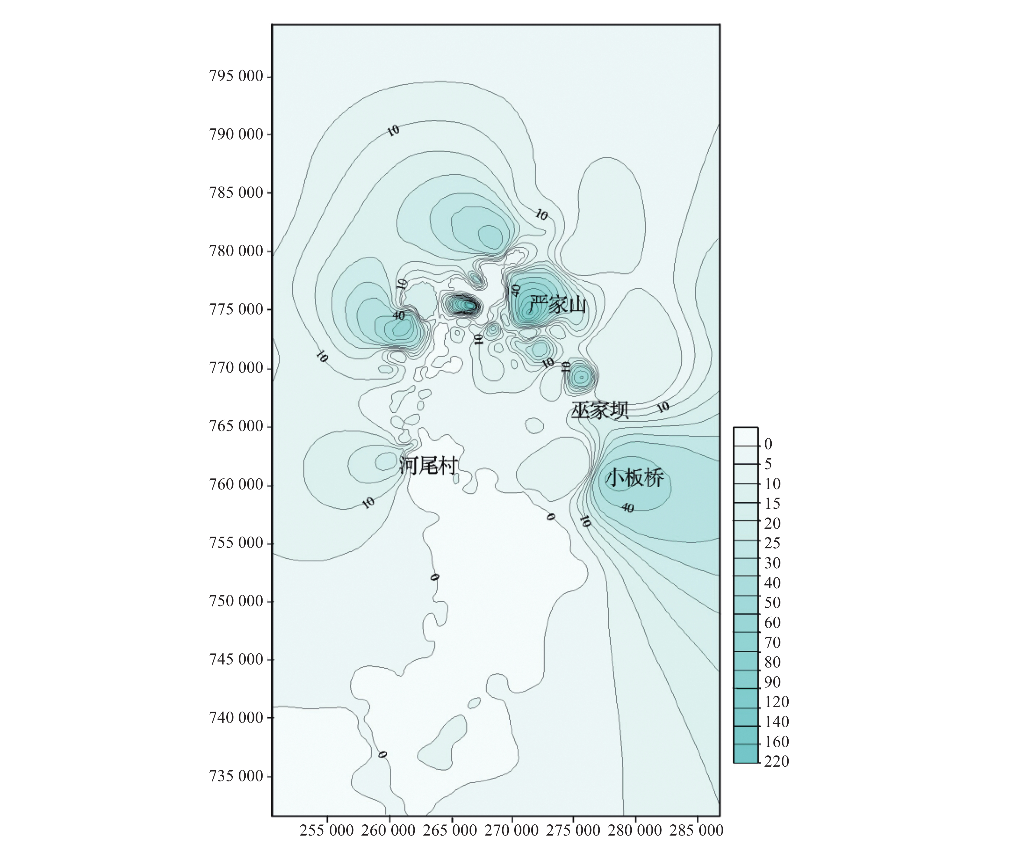
图 6 2020年昆明盆地基岩水等水位线图
Figure 6. Contour map of bedrock water levels in the Kunming basin in 2020
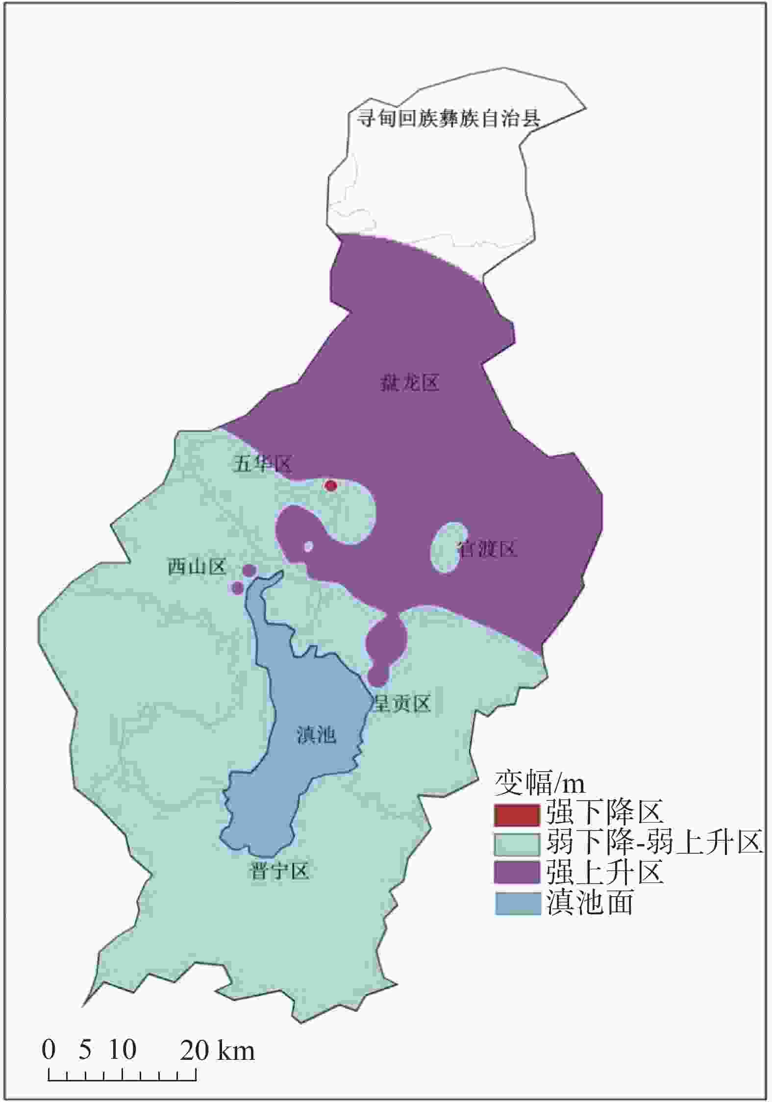
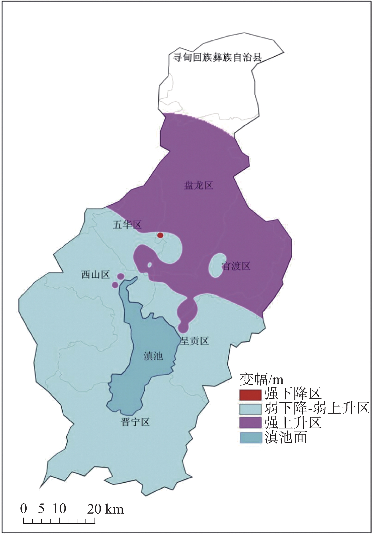
图 7 昆明盆地2006-2020年基岩水水位变幅图
Figure 7. Variations of bedrock water levels in the Kunming basin from 2006 to 2020

图 8 孔隙水典型监测点多年水位折线图
Figure 8. Line chart of multi-year water levels at representative monitoring points of pore water
表 1 基岩水典型监测井2006-2020年水位变化情况表
Table 1. Water level variations in representative monitoring wells of bedrock water from 2006 to 2020
监测井编号 地理位置 2006年水位/m 2020年水位/m 变幅/m 5301030015 盘龙区重机厂 1906.732 1896.79 −9.94 5301030283 盘龙区大树营探矿厂 1877.783 1889.73 +11.95 5301120534 西山区马街印染厂 1877.249 1890.74 +13.49 5301020271 五华区翠湖 1884.79 1887.57 +2.78  下载: 导出CSV
表 2 孔隙水监测点2006-2020年水位变化情况表
Table 2. Variations of water levels at monitoring sites of pore water from 2006 to 2020
孔隙水编号 5301020058 5301020068 5301020116 5301020156 5301110249 5301120434 年份 水位年均值/m 2006 1880.77 1910.01 1881.98 1899.57 1895.47 1890.31 2020 1880.80 1909.06 1895.08 1899.85 1895.68 1890.38 2006-2020年变幅/m +0.03 −0.95 +13.10 +0.29 +0.22 +0.07
下载: 导出CSV
-
[1] 王宇. 云南省地下水资源潜力评价现状与问题分析[J]. 中国岩溶, 2020, 39(2):137-146.WANG Yu. Evaluation status and problems of groundwater resource potential in Yunnan Province[J]. Carsologica Sinica, 2020, 39(2): 137-146. [2] 纪永寿. 安宁温泉地下水开发利用现状及潜在的环境问题[J]. 云南环保, 1990(3):43-44, 53. [3] 武军. 昆明地区地下水位及其降落漏斗初步研究[J]. 云南地质, 1992, 11(1):75-78, 62. [4] 叶许春, 张世涛, 莫美仙, 宋学良, 张子雄. 昆明盆地浅层孔隙水水位动态变化特征及其影响因素[J]. 水文, 2007, 27(3):68-70. doi: 10.3969/j.issn.1000-0852.2007.03.019YE Xuchun, ZHANG Shitao, MO Meixian, SONG Xueliang, ZHANG Zixiong. Variation characteristics of pore-water level in Kunming basin and the concerned influence factors[J]. Journal of China Hydrology, 2007, 27(3): 68-70. doi: 10.3969/j.issn.1000-0852.2007.03.019 [5] 王宇, 何绕生, 刘海峰, 王梓溦, 晏祥省, 双灵, 彭淑惠. 昆明翠湖九龙池泉群断流原因及恢复措施[J]. 中国岩溶, 2014, 33(3):263-271. doi: 10.11932/zgyr20140301WANG YU, HE Raosheng, LIU Haifeng, WANG Ziwei, YAN Xiangsheng, SHUANG Ling, PENG Shuhui. Drought causes and restoration measures for Jiulongchi spring group within Cuihu lake, Kunming[J]. Carsologica Sinica, 2014, 33(3): 263-271. doi: 10.11932/zgyr20140301 [6] 苏伟杰. 张家口市内陆平原区20年间地下水位变化趋势分析[J]. 河北建筑工程学院学报, 2015, 33(1):56-59.SU Weijie. Analysis on the change trend of groundwater in plain area of the city for 20 years Zhangjiakou inland[J]. Journal of Hebei Institute of Architecture and Civil Engineering, 2015, 33(1): 56-59. [7] 徐淑波, 徐立荣, 梅泽本. 济南引黄灌区近20年地下水位动态变化及趋势分析[J]. 中国农村水利水电, 2016(5):68-76.XU Shubo, XU Lirong, MEI Zeben. The dynamic change and trend of groundwater level in Jinan Yellow River irrigation region more than twenty years[J]. China Rural Water and Hydropower, 2016(5): 68-76. [8] 李芸, 张楠. 昆明盆地地下水超采区水资源评价[J]. 长江科学院院报, 2017, 34(6):35-38, 44. doi: 10.11988/ckyyb.20160299LI Yun, ZHANG Nan. Assessment of groundwater overdraft zones in Kunming basin[J]. Journal of Yangtze River Scientific Research Institute, 2017, 34(6): 35-38, 44. doi: 10.11988/ckyyb.20160299 [9] 郭艺, 秦大军, 王枫, 甘甫平, 闫柏琨. 基于时间序列分析法的岩溶泉水位预测[J]. 中国岩溶, 2021, 40(4):689-697.GUO Yi, QIN Dajun, WANG Feng, GAN Fuping, YAN Baikun. Prediction of karst spring water level based on the time series analysis method[J]. Carsologica Sinica, 2021, 40(4): 689-697. [10] Yabusaki Shiho, Taniguchi Makoto, Tayasu Ichiro, Akimichi Tomoya, Ohmori Noboru, Gotou Ken, Watanabe Hitoshi, Watanabe Souichirou, Furuya Syuichi. Water quality characteristics and dynamics of groundwater and spring water revealed by multi-tracers in Oshino, Yamanashi, Japan[J]. Geochemical Journal, 2023, 57(1): 28-41. [11] Coda Silvio, Tufano Rita, Calcaterra Domenico, Colantuono Pasquale, De Vita Pantaleone, Di Napoli Mariano, Guerriero Luigi, Allocca Vincenzo. Groundwater flooding hazard assessment in a semi-urban aquifer through probability modelling of surrogate data[J]. Journal of Hydrology, 2023, 621: 129659. [12] Halder Sudipa, Roy Malabika Biswas, Roy Pankaj Kumar, Sedighi Majid. Groundwater vulnerability assessment for drinking water suitability using Fuzzy Shannon Entropy model in a semi-arid river basin[J]. Catena, 2023, 229: 107206. [13] Rojas Rodrigo, Gonzalez Dennis, Fu Guobin. Resilience, stress and sustainability of alluvial aquifers in the Murray-Darling Basin, Australia: Opportunities for groundwater management[J]. Journal of Hydrology: Regional Studies, 2023, 47: 101419. [14] Rusli S R, Bense V F, Taufiq A, Weerts A H. Quantifying basin-scale changes in groundwater storage using GRACE and one-way coupled hydrological and groundwater flow model in the data-scarce Bandung groundwater basin, Indonesia[J]. Groundwater for Sustainable Development, 2023, 22: 100953. [15] 李芸, 杨秋萍, 肖振国. 昆明盆地浅层地下水脆弱性评价[J]. 地下水, 2016, 38(1):53-55. [16] 中国地质环境监测院. 中国地质环境监测地下水位年鉴[M]. 北京:中国大地出版社, 2020. [17] 云南省环境地质监测总站. 安宁地区环境水文地质调查报告[R]. 1989. [18] 彭淑惠, 王宇, 张世涛. 昆明岩溶断陷盆地的环境地质问题及治理对策[J]. 地质灾害与环境保护, 2008, 19(2):98-103. doi: 10.3969/j.issn.1006-4362.2008.02.020PENG Shuhui, WANG Yu, ZHANG Shitao. The environmental and geological problems and the countermeasures of the karst fault basin in Kunming[J]. Journal of Geological Hazards and Environment Preservation, 2008, 19(2): 98-103. doi: 10.3969/j.issn.1006-4362.2008.02.020 [19] 颜翠翠, 谭志容, 朱恒华, 王炜龙. 鲁中南基岩地区水文地质特征及地下水环境地质问题分析[J]. 钻探工程, 2021, 48(3):152-160. doi: 10.12143/j.ztgc.2021.03.022YAN Cuicui, TAN Zhirong, ZHU Henghua, WANG Weilong. Analysis of hydrogeological characteristics and groundwater environmental geological problems in the bedrock area in central and southern Shandong Province[J]. Drilling Engineering, 2021, 48(3): 152-160. doi: 10.12143/j.ztgc.2021.03.022 [20] 杨彩霞. 地下水位下降引起的环境地质问题探讨[J]. 科技创新导报, 2013(2):137. [21] 殷勇. 城市地下水开发引起的环境地质问题刍议[J]. 地下水, 2009, 31(6):134-136.YIN Yong. Primary opinion on environmental geological problems caused by groundwater exploitation in the urban[J]. Ground Water, 2009, 31(6): 134-136. [22] 康晓莉, 周俊蓉, 高瑜, 张华. 昆明盆地地下水水质水位长序列数据特征分析[J]. 中国岩溶, 2023, 42(4):662-671. doi: 10.11932/karst20230403KANG Xiaoli, ZHOU Junrong, GAO Yu, ZHANG Hua. Characteristics of long series data of groundwater quality and level in Kunming basin[J]. Carsologica Sinica, 2023, 42(4): 662-671. doi: 10.11932/karst20230403 -


 点击查看大图
计量
- 文章访问数: 1003
- HTML浏览量: 501
- PDF下载量: 75
- 被引次数: 0
