Research on hydrogeomorphologic characteristics and evolution of the watershed on the Gaopo karst tableland in Huaxi of Guizhou
-
摘要: 为了探讨贵州花溪高坡岩溶高原台地分水岭水文地貌特征及形成机制,文章通过实地调查区内地质构造、岩性、地貌空间展布特征,结合区内水系特征,运用岩溶水文地貌学理论探讨其发育与演化。结果表明:①高坡岩溶台地坡立谷、边缘坡立谷、峰林谷地、岛状峰丛和岩溶洞穴等岩溶地貌较为发育,展现出层状结构特征;②峰林谷地主要发育在独木河与摆金河之间的分水岭区域;③地貌由分水岭向排泄基面呈峰林谷地→峰丛洼地→谷地(或孤峰)的展布特征。分析认为:①裂隙、节理与断裂等构造是控制区内谷地向北东、东南走向的主导因素,碳酸盐岩和非碳酸盐岩地层空间展布对岩溶地貌形态具有一定决定作用,地壳抬升是塑造层状地貌结构的直接动力;②区内岩溶台地地貌形成演化是随台地水文结构演变而演进,在地质历史过程中,台地水系受周围河流溯源侵蚀影响,由边缘向中心解体;③在此过程,高坡岩溶台地岩溶地貌经历了:石牙-湖泊、峰丛洼地、峰林谷地和台地地貌系统退化消亡等4个时期。Abstract:
In order to explore the hydrogeomorphologic characteristics and formation mechanism of the watershed on the Gaopo karst tableland in Huaxi, Guizhou, this study investigates the spatial distribution of geological structure, lithology and geomorphology, in conjunction with the hydrological characteristics of the study area. It employs the theory of karst hydrogeomorphology to discuss the development of these characteristics. The results indicate: (1) The karst landforms of the Gaopo karst tableland, including poljes, edge poljes, peak-forest valleys, island peak clusters and karst caves, are well developed and exhibit layered structural characteristics. (2) The peak-forest valley is mainly developed in the watershed area between the Dumu river and the Baijin river. (3) The landform transitions from the watershed to the drainage base, displaying a spatial distribution pattern of peak-forest valley→peak-cluster depression→valley (or isolated peak). The analysis shows that fractures, joints and faults are the dominant factors controlling the northeastward and southeastward trend of the valley in the study area. Spatial distributions of carbonate rocks and non-carbonate strata play a certain decisive role in karst geomorphology. On the Gaopo karst tableland in Huaxi, there is an erosion base at Grade-5 in the valley and at the transition end of the broad anticline, but not in the watershed area. This phenomenon is caused by the fact that the crust began to rise again before the river tractive erosion in a certain period spread to the study area. In the broad anticline area, the tractive erosion path of the previous period spread to the center area, so only a Grade-4 erosion base was formed in the study area. Based on the layered geomorphic structure, it can be seen that from the center to the edge of the tableland and then to the valley, there is a turning point in the erosion base at the edge of tableland. In addition, the erosion base of each grade from the anticlinal transition end to the anticlinal center (from the edge to the center of tableland) is relatively stable with small hydraulic gradients, but the hydraulic gradients in erosion bases from the transition end to the synclinal valley are much larger than those on the anticline. Therefore, in the process of drainage from the center to the edge of tableland and then to the valley, there is also a turning point for the groundwater level as well as the surface water level of Gaopo karst tableland at its edge. As a result, the flowing rates of both the surface runoff and groundwater runoff on the box anticlinal karst tableland are slow, or the runoffs are transformed into karst lakes and pools inside the box anticlinal karst tableland, whose side erosion is strong, forming karst landforms of peak-forest plain, peak-forest valley, etc. However, with the gradual strengthening of traceable erosion, the turning point also gradually retreated to the center of the tableland, and finally the groundwater level of the tableland disappeared. With the retreat of the turning point, the groundwater level gradually decreased, the saturation zone gradually thickened, and the movement of surface water and groundwater shifted from the horizontal to the vertical. As a result, a large number of depressions, funnels, sinkholes and vertical shafts were developed on the surface. Therefore, it is believed that the formation and evolution of karst geomorphology in the watershed area of the Gaopo karst tableland in Huaxi are closely linked to the development of platform hydrological structure. Throughout geological history, the platform water system has been affected by the tractive erosion caused by surrounding rivers, leading to the disintegration of the surface hydrological network from the edges toward the center of the platform. In this process, the karst geomorphology of the Gaopo karst tableland experienced four stages: stone clint-lake, peak-cluster depression, peak-forest valley and the degradation and extinction of platform geomorphology system. -
Key words:
- karst tableland /
- watershed /
- hydrogeomorphology /
- the Gaopo karst tableland
-
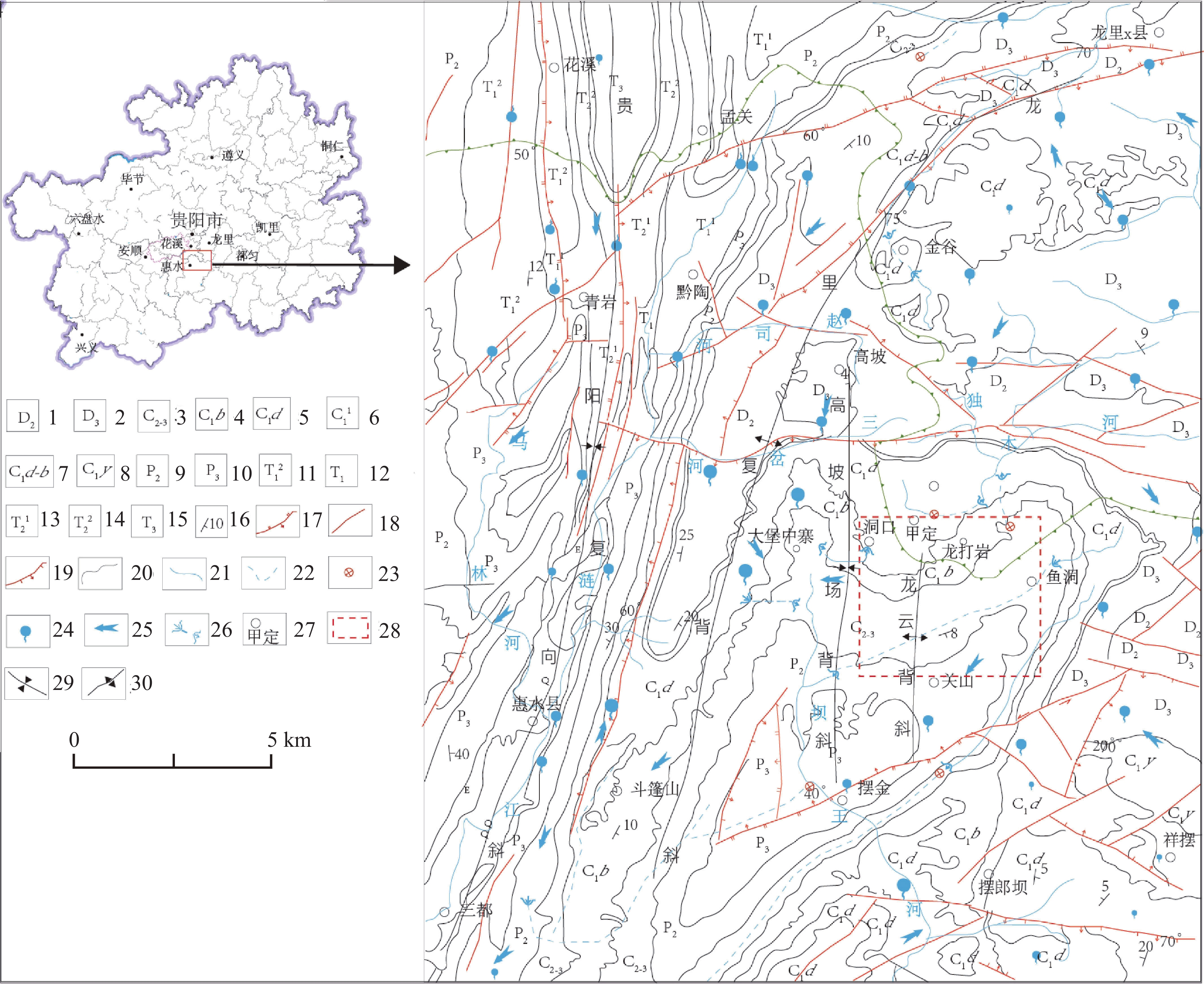
图 1 研究区地质概况
1.泥盆系中统 2.泥盆系上统 3.石炭系中上统 4.石炭系下统摆佐组 5.石炭系下统大塘阶 6.石炭系下统一段 7.石炭系下统大塘阶至摆佐组 8.石炭系下统严关阶 9.二叠系中统 10.二叠系上统 11.三叠系下统二段 12.三叠系下统 13.三叠系中统一段 14.三叠系中统二段 15.三叠系上统 16.岩层产状 17.逆断层 18.性质不明断层 19.正断层 20.地层线 21.地表河流 22.地下河 23.落水洞 24.泉水 25.径流方向 26.地下河出入口 27.地名 28.研究区 29.向斜 30.背斜
Figure 1. Geological overview of the study area
1. Middle Devonian System 2. Upper Devonian System 3. Middle Upper Carboniferous System 4. Baizuo Formation of Lower Carboniferous 5. Datang Stage of Lower Carboniferous System 6. the first member of Lower Carboniferous System 7. Datang Stage to Baizuo Formation of Lower Carboniferous System 8. Yanguan Stage of Lower Carboniferous System 9. Middle Permian System 10. Upper Permian System 11.the second member of Lower Triassic System 12. Lower Triassic System 13.the first member of Middle Triassic System 14. the second member of Middle Triassic System 15. Upper Triassic System 16. occurrence of rock strata 17. reverse fault 18. unknown fault 19. normal fault 20. stratigraphic line 21. surface river 22. underground river 23. sinkhole 24. spring 25. runoff direction 26. entrance and outlet of the underground river 27. place name 28. the study area 29. syncline 30. anticline
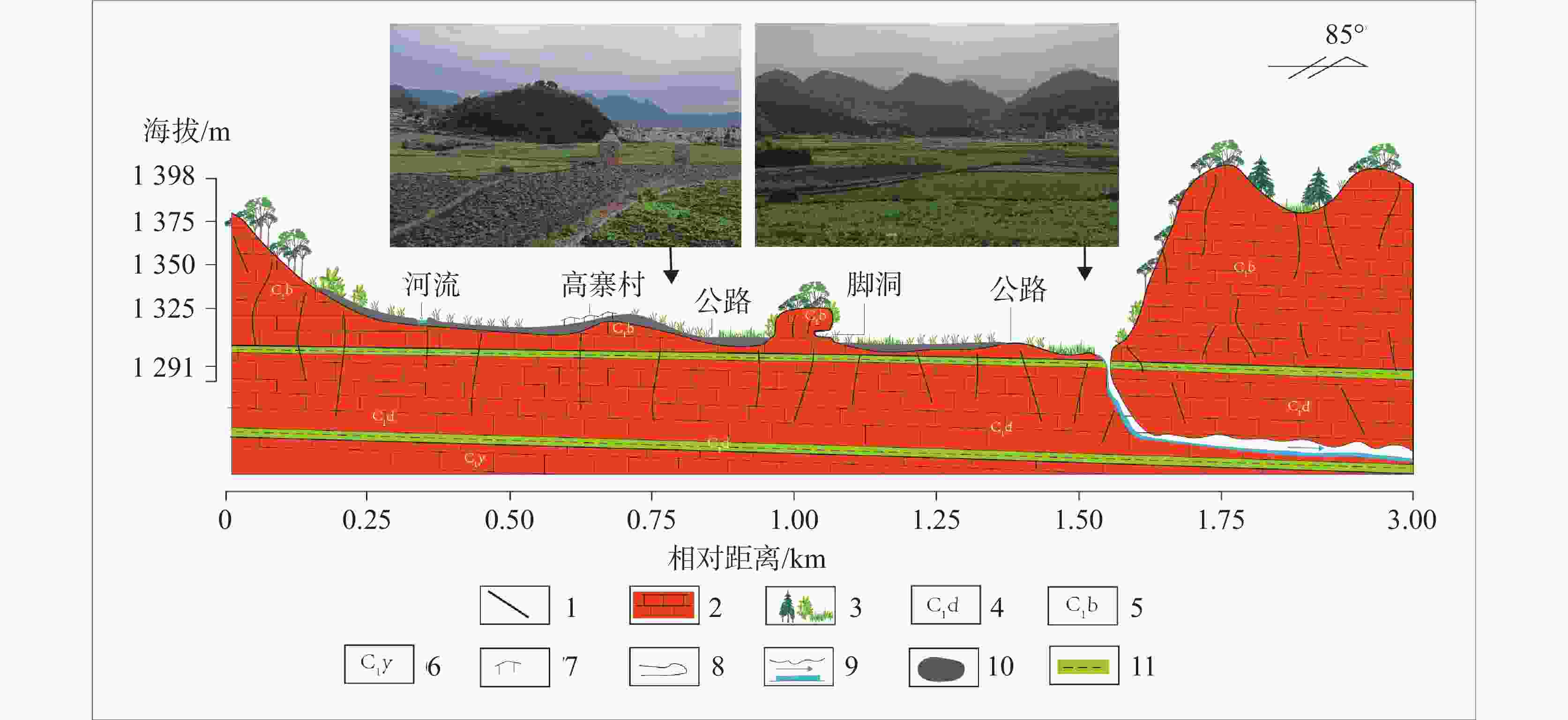
图 4 甲定边缘坡立谷剖面图
1.节理 2.碳酸盐岩 3.植被 4. 石炭系下统大唐阶 5.石炭系下统摆佐组 6.石炭系下统严关阶 7.房屋 8.洞穴 9.地下河及方向 10.土壤 11.非碳酸盐岩夹层
Figure 4. Section of the polje at the edge of Jiading village
1. joint 2. carbonate rock 3. vegetation 4. Datang stage of lower Carboniferous system 5. Baizuo formation of lower Carboniferous system 6. Yanguan stage of lower Carboniferous system 7.House 8. Cave 9. Underground river and its direction 10. soil 11. interlayer of non-carbonate rock
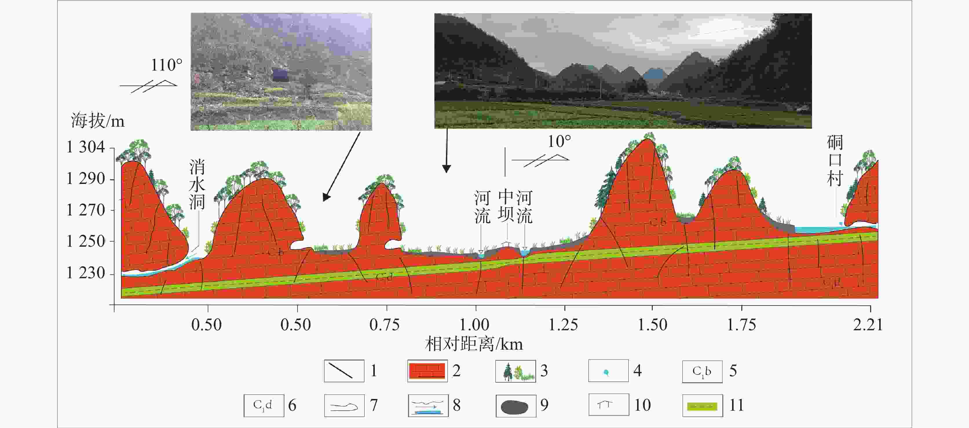
图 7 坡立谷及峰林地貌剖面
1.节理 2.碳酸盐岩 3.植被 4.泉点 5.石炭系下统摆佐组 6.石炭系下统大塘阶 7.洞穴 8.地下河及方向 9.土壤 10.村寨 11.非碳酸盐岩夹层
Figure 7. Geomorphology of polje and peak-forest
1. joint 2. Carbonate rock 3. vegetation 4. spring point 5. Baizuo formation of lower Carboniferous system 6. Datang stage of lower Carboniferous system 7. cave 8. Underground river and its direction 9. soil 10. village 11. interlayer of non-carbonate rock
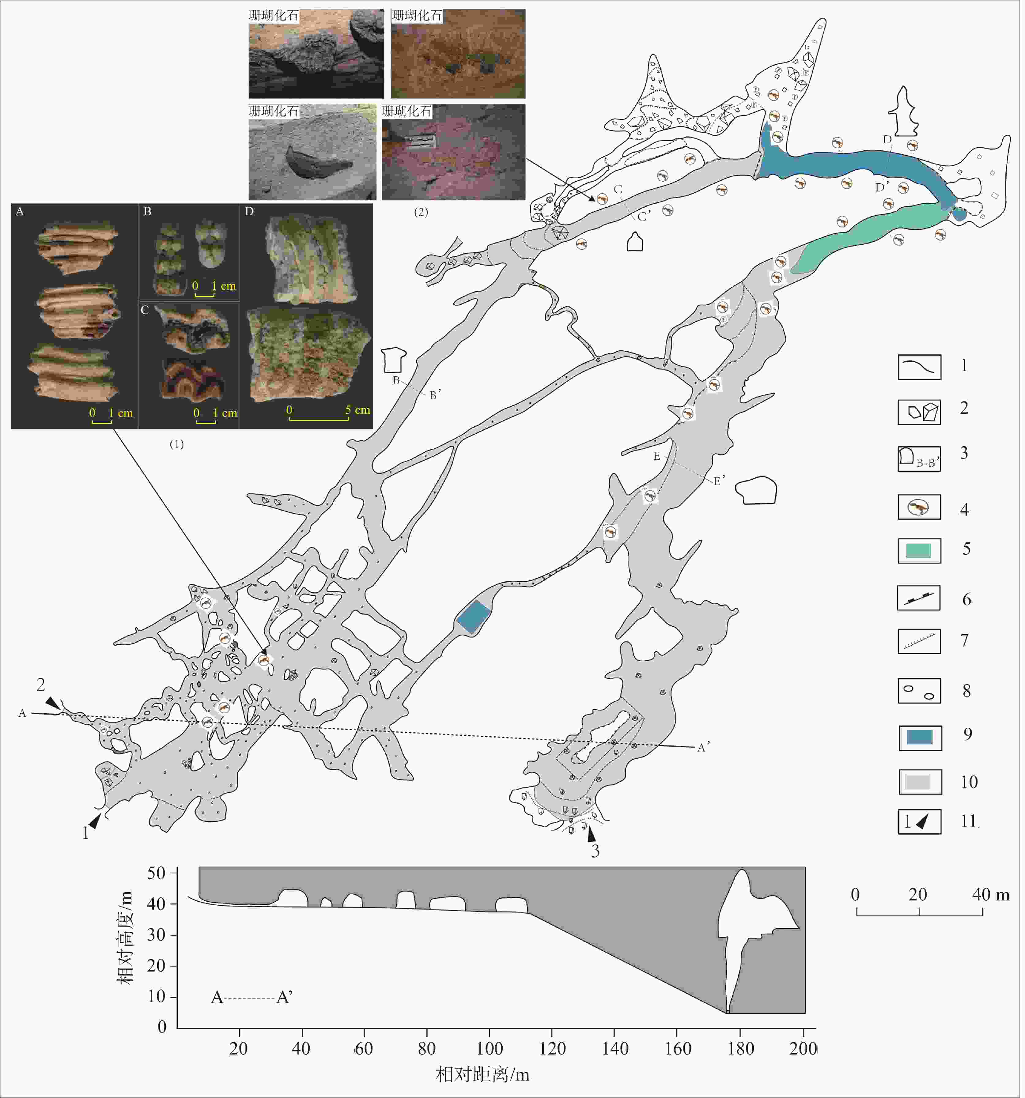
图 9 龙打岩洞洞穴图(洞穴图据高占冬,毛永琴,周文龙,2020,改)
1.洞道边界 2.石块 3.洞穴横截面 4.化石 5.季节性池水 6.陡坎 7.缓坡 8.卵石 9.常年池水 10.黏土 11.主要洞口注:(1)脊椎动物化石:a.牛、b.野猪、c.犀牛、d.剑齿象 (2)无脊椎动物化石
Figure 9. Map of Longdayan cave (Modified according to Gao Zhandong, Mao Yongqin & Zhou Wenlong, 2020)
1. cave boundary 2. rock 3. cross-section of the cave 4. fossil 5. seasonal pool water 6. steep slope 7. gentle slope 8. pebble 9. perennial pool water 10. clay 11. main entrance of the cave Note: (1) vertebrate fossils, a. cattle, b. wild boar, c. rhinoceros, d. stegodon (2) invertebrate fossilsNote: (1) vertebrate fossils, a. cattle, b. wild boar, c. rhinoceros, d. stegodon (2) invertebrate fossils
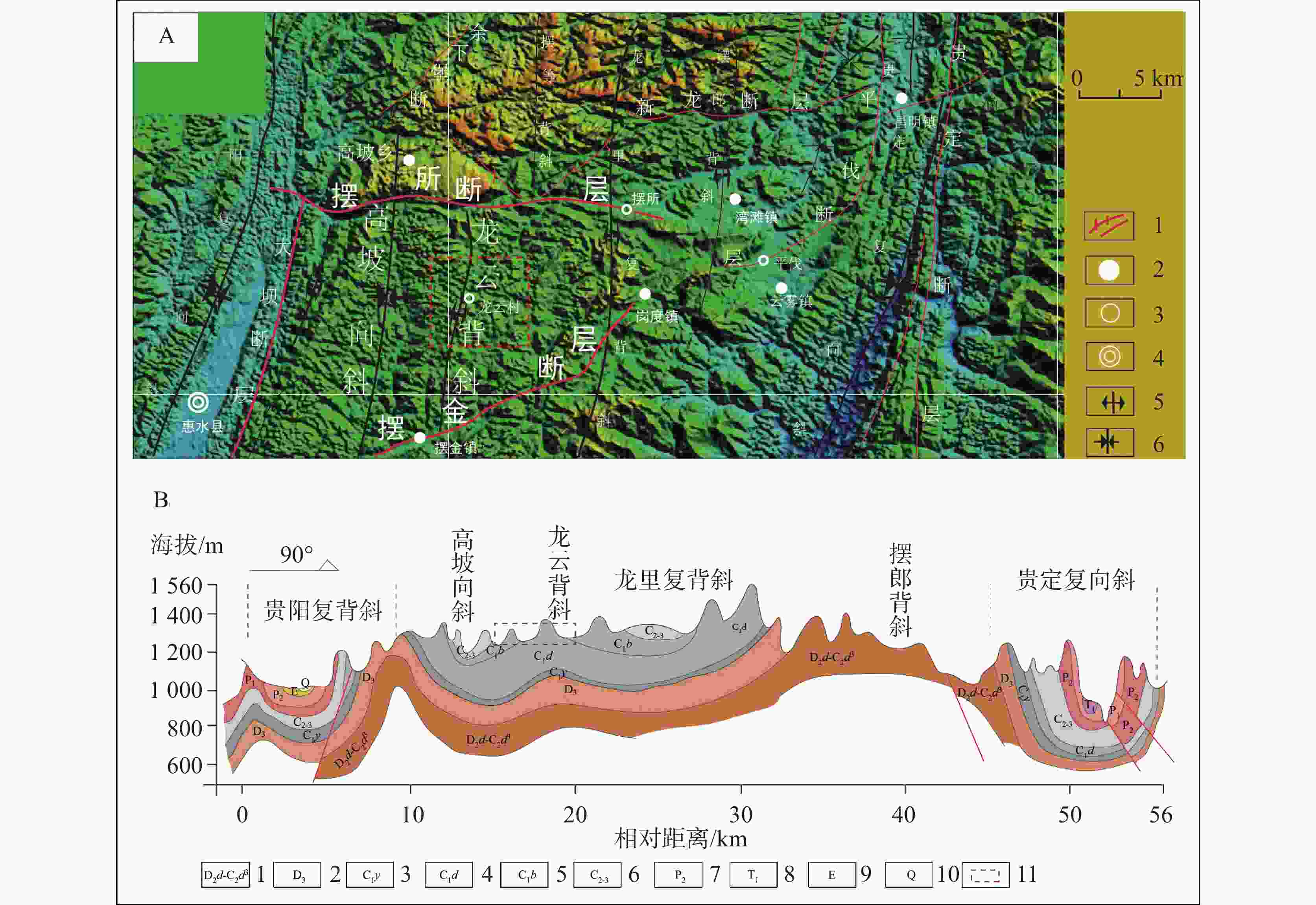
图 10 区内褶皱展布图
A:1.断层 2.村 2.乡镇 3.县城 5.背斜 6.向斜B:1.泥盆系中统独山组 2.泥盆系上统 3.石炭系下统严关阶 4.石炭系下统大塘阶 5.石炭系下统摆佐组 6.石炭系中上统 7.二叠系中统 8.三叠系下统 9.第三系 10.第四系 11.研究区
Figure 10. Fold layout in the area
A:1. fault 2. village 2. town and village 3. county 5. anticline 6. syncline B:1. Dushan formation of Middle Devonian system 2. Upper Devonian system, 3. Yanguan stage of Carboniferous system 4. Datangian stage of lower Carboniferous system 5. Baizuo formation of lower Carboniferous system 6. middle upper Carboniferous system 7. middle Permian system 8. lower Triassic system 9. Tertiary system 10. Quaternary system 11. the study area
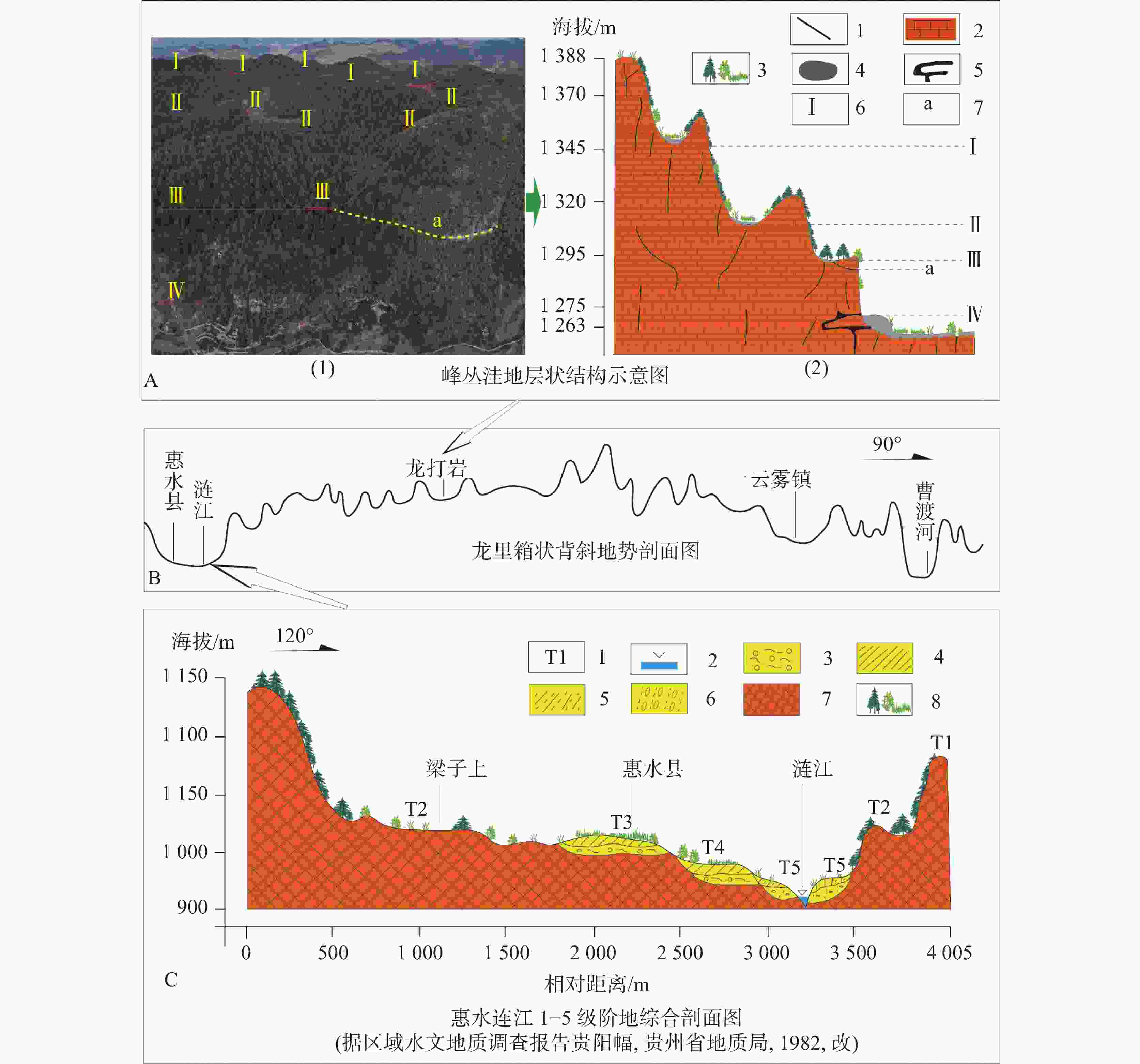
图 12 台地两侧河流阶地与台地峰丛洼地结构图
A:1.节理 2.碳酸盐岩 3.植被 4.土壤 5.洞穴 6.洼地层次 7.残留边槽状洞穴 C:1.河流阶地 2.河流 3.泥砾 4.亚黏土 5.亚砂土 6.砾石 7.基岩 8.植被
Figure 12. Structures of river terrace and peak-cluster depression in the area
A:1. joint 2. carbonate rock 3. vegetation 4. soil 5. cave 6. depression level 7. residual edge cave C: 1. river terrace 2. river 3. mud gravel 4. sub-clay 5. sub-sandy soil 6. gravel 7. bedrock 8. vegetation
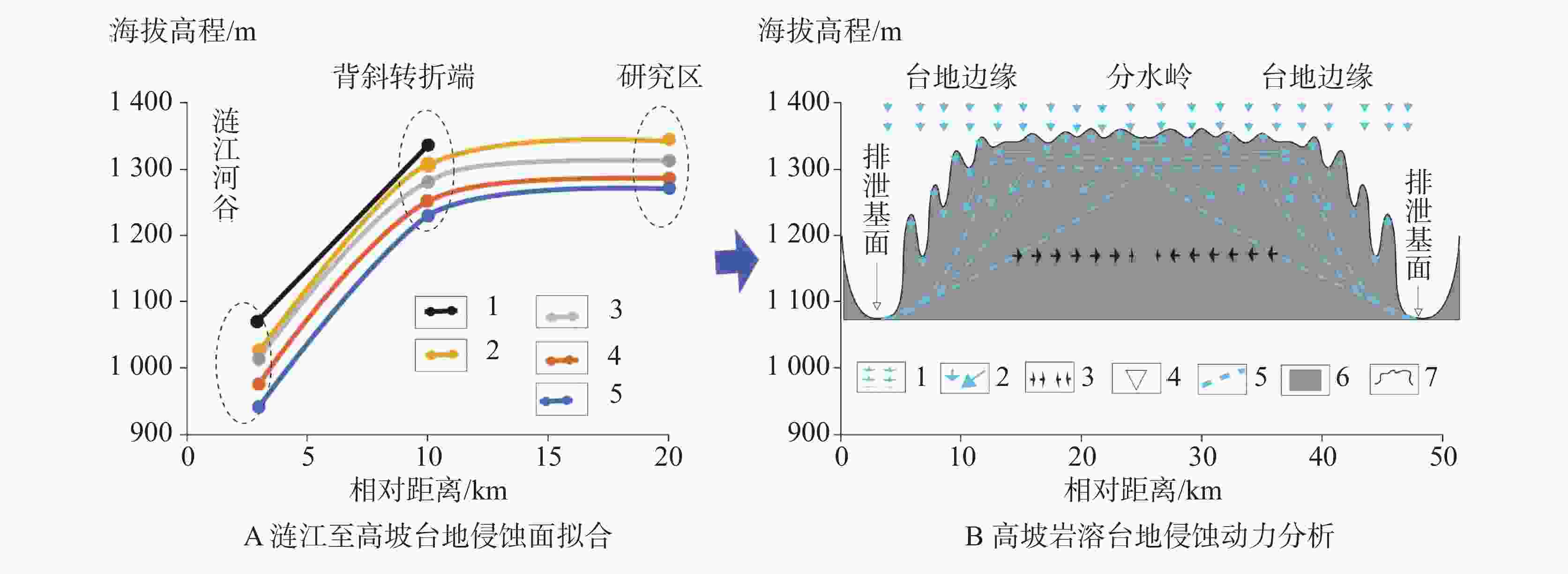
图 14 侵蚀基面及动力示意图
A:1.一级侵蚀基面 2.二级侵蚀基面 3.三级侵蚀基面 4.四级侵蚀基面 5.五级侵蚀基面 B:1.降水 2.地下径流;3.地下水位后退方向 5.地下水位 6.基岩 7.地表剖面线
Figure 14. Schematic diagram of erosion base and dynamics
A: 1. primary erosion base surface 2. secondary erosion base surface 3. tertiary erosion base surface 4. fourth erosion base surface 5. fifth erosion base surface B: 1. precipitation 2. underground runoff 3. receding direction of groundwater table 5. underground water table 6. bed rock 7. surface profile line
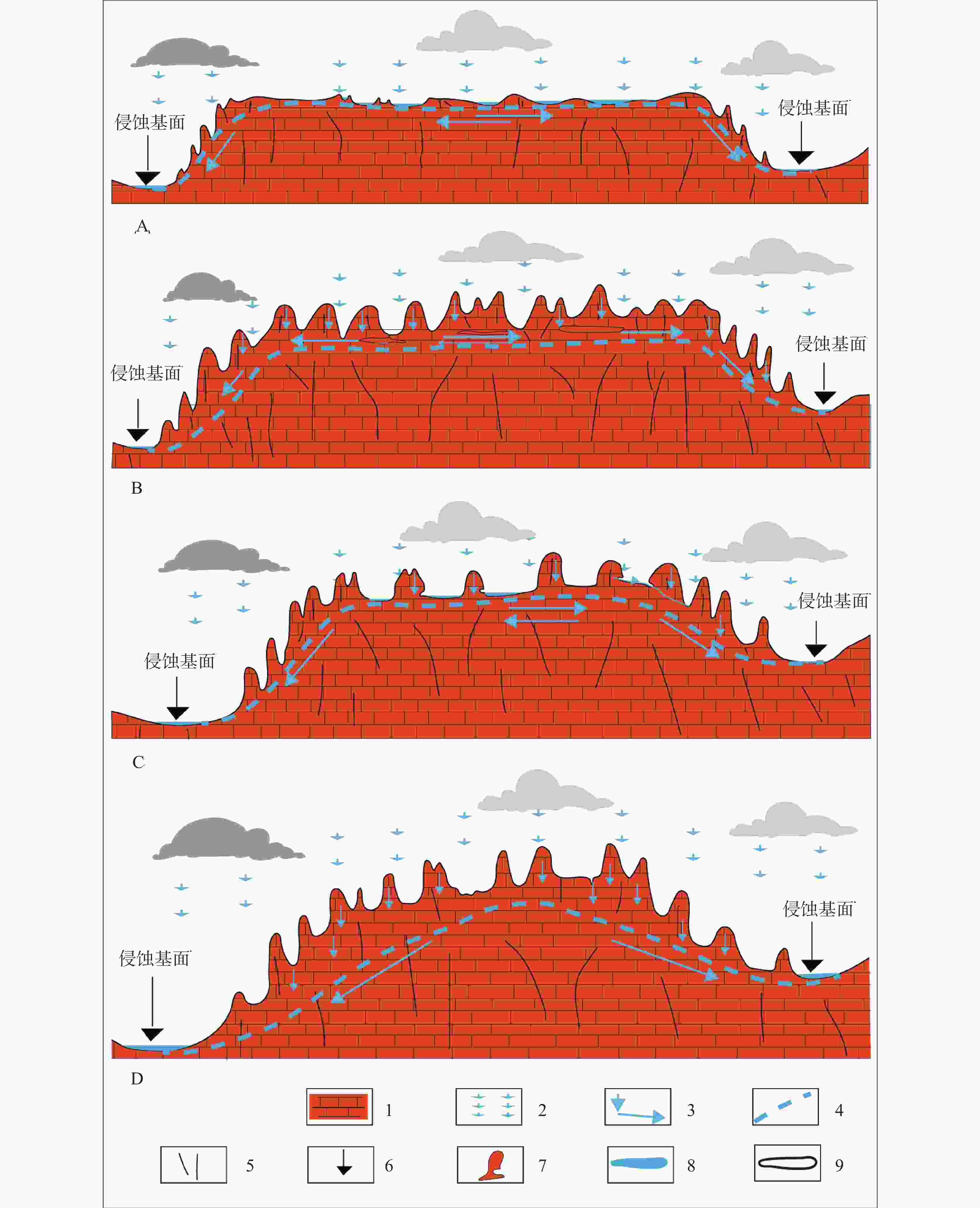
图 15 区内岩溶台地水文地貌形成演化示意图
1.碳酸盐岩 2.降水 3.地下水径流方向 4.地下水位 5.裂隙和节理 6.地表河 7.脚洞 8.地表湖泊 9.洞穴
Figure 15. Development and evolution of karst hydrogeomorphology in the area
1. carbonate rock 2. precipitation 3.direction of groundwater runoff 4. water table 5. fissure and joint 6. surface river 7. foot cave 8. surface lake 9. cave
表 1 区内岩层与地貌景观对比
Table 1. Comparison of rock strata and geomorphic landscape in the area
地层 岩性 地貌 石炭系 下统 大塘阶 (C1d ) 灰白色中厚层至薄层石英砂岩深灰色砂质页岩、黑色炭质页岩,夹 1~4层煤线或煤层 洼地、缓丘、边缘坡立谷 摆佐组(C1b ) 厚层灰岩夹白云岩,局部夹燧石条带及泥质灰岩 峰丛洼地、峰林谷地、坡立谷、石牙、溶洞、地下河 中上统 黄龙、马平群
(C2h-C3m)厚层块状中粗晶白云岩、灰岩、白云岩质灰岩 峰丛洼地、峰林谷地 二叠系 中统 栖霞组和茅口组
(P2q-m)深灰色至浅灰色厚层块状灰岩夹燧石灰岩 竖井、漏斗、落水洞、岩溶峡谷、峰林、峰丛、溶洞、泉、瀑布、地下河 -
[1] Ford D C, Williams P W. Karst Hydrogeology and Geomorphology[M]. Chichester, United Kingdom: John Wiley & Sons Ltd., 2007. [2] 袁道先, 蒋勇军, 沈立成, 蒲俊兵, 肖琼, 等. 现代岩溶学[M]. 北京:科学出版社, 2016. [3] 胡宝清. 喀斯特人地系统研究[M]. 北京:科学出版社, 2014.HU Baoqing. Study on human-land systems in karst areas[M]. Beijing: Science Press, 2014. [4] 曾昭璇. 中国南部石灰岩地貌类型若干问题[J]. 地质学报, 1964, 44(1):119-128.TSENG Chiusuen. Some questions on the classification of relief types in karst region in South China[J]. Acta Geologica Sinica, 1964, 44(1): 119-128. [5] Annable W K. Numerical analysis of conduit evolution in karstic aquifers[D]. Waterloo, Canada: University of Waterloo, 2003. [6] Radulović M M. A new view on karst genesis[J]. Carbonates and Evaporites, 2013, 28(4): 383-397. doi: 10.1007/s13146-012-0125-2 [7] Mozafari M, Sajjadian M, Sorninia Y, Bagheri R, Ghader F. Hydrogeology and geomorphology of Bisetun aquifer (NW Iran): Interesting example of deep endokarst[J]. Carbonates and Evaporites, 2020, 35(4): 115. [8] Cvijič J. Geography of the limestone terrains[A]//Cvijič J. Geography of karst (unpublished works). Belgrade, Republic of Serbia: Serbian Academy of Sciences and Arts, 1989: 125-270. [9] 王克林, 陈洪松, 曾馥平, 岳跃民, 张伟, 付智勇. 生态学研究支撑喀斯特区域生态环境治理与科技扶贫[J]. 中国科学院院刊, 2018, 33(2):213-222.WANG Kelin, CHEN Hongsong, ZENG Fuping, YUE Yuemin, ZHANG Wei, FU Zhiyong. Ecological research supports ecological environment management and poverty alleviation in karst region of Southwest China[J]. Bulletin of the Chinese Academy of Sciences, 2018, 33(2): 213-222. [10] 袁道先. 论峰林地形[J]. 广西地质, 1984(1):79-86. [11] 任美锷, 刘振中, 王飞燕, 等. 岩溶学概论[M]. 北京:商务印书馆, 1983. [12] 宋林华. 喀斯特地貌研究进展与趋势[J]. 地理科学进展, 2000, 19(3):193-202. doi: 10.3969/j.issn.1007-6301.2000.03.001SONG Linhua. Progress and trend of karst geomorphology study[J]. Progress in Geography, 2000, 19(3): 193-202. doi: 10.3969/j.issn.1007-6301.2000.03.001 [13] Cvijič J. Das karstphanomen: Versuch einer morphologichen monographie[J]. Geographische Abhandlungen, 1893, 5(3): 217-330. [14] Cvijič J. Karst, geographic monograph (in Serbian)[M]. Belgrade, Republic of Serbia: Royal Publishing House of Serbia, 1895b. [15] Shanov S, Kostov K. Tectonic control on karst evolution[J]. Dynamic Tectonics and Karst, 2015:1-5. [16] Cvijič J. Hydrographie souterraine et évolution morphologique du karst[J]. Revue de Géographie Alpine, 1918, 6(4): 375-426. https://doi.org/10.3406/rga.1918.4727. [17] Jakucs L. Morphogenetics of karst regions: Variants of karst evolution[M]. Hungary: Akadémiai Kiadó, 1977. [18] Veress M. Covered karst[M]. Berlin, Heidelberg: Springer, 2016. [19] Bakalowicz M. Géochimie des eaux et fux de matières dissoutes: L'approche objective du rôle du climat dans la karstogenese[J]. Karst Evolutions Climatiques, 1992: 61-74. [20] Márton V. Karst types and their karstification[J]. Journal of Earth Science, 2020, 31(3): 621-634. [21] 杨明德, 谭明, 梁虹. 喀斯特流域水文地貌系统[M]. 北京:地质出版社, 1998. [22] 罗书文, 贺卫, 杨桃, 邓亚东, 吕勇, 吴克华, 孟庆鑫. 湘桂走廊地貌发育特征的地学意义及形成机制研究[J]. 中国岩溶, 2021, 40(5):750-759. doi: 10.11932/karst20210502LUO Shuwen, HE Wei, YANG Tao, DENG Yadong, LV Yong, WU Kehua, MENG Qingxin. Geological significance of the development characteristics of karst geomorphology and its formation mechanism in Hunan-Guangxi corridor[J]. Carsologica Sinica, 2021, 40(5): 750-759. doi: 10.11932/karst20210502 [23] Ghahrodi M, Jalilian T, Alijani F. Detection of karstic groundwater flow system: A case study of prao-bisetoun limestone mass, Kermanshah Province, Iran[J]. International Bulletin of Water Resources & Development, 2014, 2(4): 27-39. [24] Klimchouk A. The karst paradigm: Changes, trends and persepctives[J]. Acta Carsologica, 2015, 44(3): 289-313. [25] 朱学稳. 峰林喀斯特的性质及其发育和演化的新思考(1)[J]. 中国岩溶, 1991, 10(1):51-62.ZHU Xuewen. New considerations on characteristics and evolution of Fenglin karst[J]. Carsologica Sinica, 1991, 10(1): 51-62. [26] 朱学稳. 峰林喀斯特的性质及其发育和演化的新思考(2)[J]. 中国岩溶, 1991, 10(2):137-150.ZHU Xuewen. New consicerations on the characteristics and evolution of the Fenglin karst (the second continuance)[J]. Carsologica Sinica, 1991, 10(2): 137-150. [27] 朱学稳. 峰林喀斯特的性质及其发育和演化的新思考(3)[J]. 中国岩溶, 1991, 10(3):171-182.ZHU Xuewen. New considerations on characteristics and evolution of Fenglin karst[J]. Carsologica Sinica, 1991, 10(3): 171-182. [28] 贵州省地质矿产局. 贵州省区域地质志[M]. 北京:地质出版社, 1987:586-588.Guizhou Bureau of Geology and Mineral Exploration and Development. Regional Geology of Guizhou Province[M]. Beijing: Geological Publishing House, 1987: 586-588. [29] 张竹如, 唐波, 蒋玺, 李燕. 龙里高山草原形成机理与旅游资源初评[J]. 中国岩溶, 2001, 20(1):53-57. doi: 10.3969/j.issn.1001-4810.2001.01.010ZHANG Zhuru, TANG Bo, JIANG Xi, LI Yan. The forming process of the Longli alpine meadow and evaluation of its tourism resourec[J]. Carsologica Sinica, 2001, 20(1): 53-57. doi: 10.3969/j.issn.1001-4810.2001.01.010 [30] De Waele J, Plan L, Audra P. Recent developments in surface and subsurface karst geomorphology: An introduction[J]. Geomorphology, 2009, 106: 1-8. [31] 王宇. 岩溶高原地下水径流系统垂向分带[J]. 中国岩溶, 2018, 37(1):1-8. doi: 10.11932/karst20180101WANG Yu. Vertical zoning of groundwater runoff system in karst plateau[J]. Carsologica Sinica, 2018, 37(1): 1-8. doi: 10.11932/karst20180101 -


 下载:
下载:


