- Included in CSCD
- Chinese Core Journals
- Included in WJCI Report
- Included in Scopus, CA, DOAJ, EBSCO, JST
- The Key Magazine of China Technology
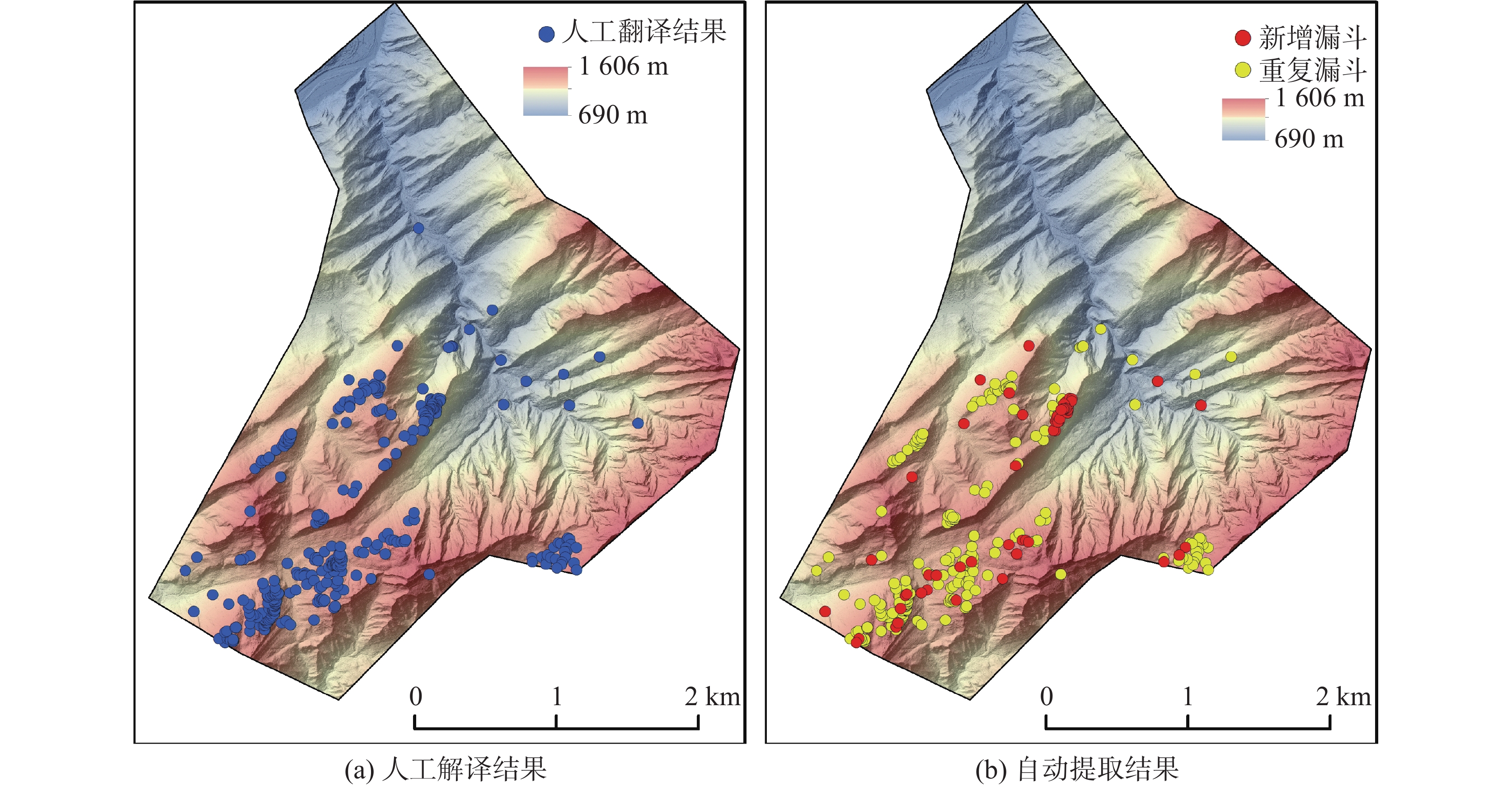
| Citation: | FU Mingjun, HE Yang, DONG Xiujun, DENG Bo. Research on remote sensing identification of dolines with dense vegetation cover based on point cloud principal component analysis point cloud principal component analysis[J]. CARSOLOGICA SINICA, 2025, 44(1): 89-99. doi: 10.11932/karst20250106

|

| [1] |
曹建华, 蒋忠诚, 袁道先, 夏日元, 章程. 岩溶动力系统与全球变化研究进展[J]. 中国地质, 2017, 44(5):874-900. doi: 10.12029/gc20170504
CAO Jianhua, JIANG Zhongcheng, YUAN Daoxian, XIA Riyuan, ZHANG Cheng. The progress in the study of the karst dynamic system and global changes in the past 30 years[J]. Geology in China, 2017, 44(5): 874-900. doi: 10.12029/gc20170504
|
| [2] |
曾洁, 潘晓东, 任坤, 刘伟, 彭聪, 郑智杰. 贵州省碧云湖岩溶渗漏水文地质条件与渗漏管道位置识别[J]. 中国岩溶, 2024, 43(1):201-208. doi: 10.11932/karst20240101
ZENG Jie, PAN Xiaodong, REN Kun, LIU Wei, PENG Cong, ZHENG Zhijie. Hydrogeological conditions of karst leakage and locating of leakage channels in Biyun lake, Guizhou[J]. Carsologica Sinica, 2024, 43(1): 201-208. doi: 10.11932/karst20240101
|
| [3] |
冯志刚, 韦国建, 张汉猛, 许国. 西南某水电站断裂构造和层间溶蚀带组合岩溶渗漏研究[J]. 中国岩溶, 2022, 41(5):728-735. doi: 10.11932/karst2021y33
FENG Zhigang, WEI Guojian, ZHANG Hanmeng, XU Guo. Study on karst leakage caused by the combination of fault structure and interlayer corrosion zone of a hydropower station in Southwest China[J]. Carsologica Sinica, 2022, 41(5): 728-735. doi: 10.11932/karst2021y33
|
| [4] |
袁道先, 蔡桂鸿. 岩溶环境学[M]. 重庆:重庆出版社, 1988.
|
| [5] |
蒋小珍, 冯涛, 郑志文, 雷明堂, 张伟, 马骁, 伊小娟. 岩溶塌陷机理研究进展[J]. 中国岩溶, 2023, 42(3):517-527. doi: 10.11932/karst20230304
JIANG Xiaozhen, FENG Tao, ZHENG Zhiwen, LEI Mingtang, ZHANG Wei, MA Xiao, YI Xiaojuan. A review of karst collapse mechanisms[J]. Carsologica Sinica, 2023, 42(3): 517-527. doi: 10.11932/karst20230304
|
| [6] |
袁道先. 现代岩溶学[M]. 北京:科学出版社, 2016.
|
| [7] |
伍法权. 西部水利水电开发与岩溶水文工程地质学术研讨会学术总结报告[J]. 工程地质学报, 2004, 12(4):441-444. doi: 10.3969/j.issn.1004-9665.2004.04.020
WU Faquan. Academic summary on the western conference of hydro-power development and karst hydro-engineering geology[J]. Journal of Engineering Geology, 2004, 12(4): 441-444 doi: 10.3969/j.issn.1004-9665.2004.04.020
|
| [8] |
卢耀如. 岩溶地区水利水电建设中一些环境地质问题的探讨[C]//喀斯特与环境地学——卢耀如院士80华诞祝寿论文选集, 2011:98-104.
|
| [9] |
李芳涛, 李华明, 胡志平, 陈南南, 晏长根. 峨汉高速廖山隧道岩溶发育规律及其工程效应浅析[J]. 中国岩溶, 2020, 39(4):592-603.
LI Fangtao, LI Huaming, HU Zhiping, CHEN Nannan, YAN Changgen. Features of karst development and geotechnical effects in the Liaoshan tunnel on the E-Han expressway[J]. Carsologica Sinica, 2020, 39(4): 592-603.
|
| [10] |
谭先亮. 拉浪水电站左岸绕坝渗漏问题的探讨[J]. 中国岩溶, 1986, 5(1):25-34.
TAN Xianliang. Discussion on bypassing leakage problem at left abutment of Lalang hydroelectric power atation[J]. Carsologica Sinica, 1986, 5(1): 25-34.
|
| [11] |
姚臣良. 大龙洞水库漏水量测验初析[J]. 广西水利水电, 1991(1):46-50.
|
| [12] |
肖万春, 王占元. 猫跳河四级水电站坝肩及坝基渗漏稳定分析[J]. 贵州水力发电, 1999(2):20-24.
XIAO Wanchun, WANG Zhanyuan. Analysis on seepage and stability of dam abutments and foundation in Cascade IV hydropower station on Maotiaohe river[J]. Guizhou Water Power, 1999(2): 20-24.
|
| [13] |
吴宗信, 梁纪信, 王德成. 桃曲坡水库灰岩库区的漏水情况及治理措施[J]. 水利水电技术, 1990(12):49-52.
|
| [14] |
曹建文, 杨海洋, 王喆, 赵良杰, 林玉山, 栾崧, 李录娟. 湖北某抽水蓄能电站建设中地下河系统多元信息综合分析评价[J]. 中国岩溶, 2023, 42(4):699-710. doi: 10.11932/karst20230406
CAO Jianwen, YANG Haiyang, WANG Zhe, ZHAO Liangjie, LIN Yushan, LUAN Song, LI Lujuan. Comprehensive analysis and evaluation of the multi-information on the underground river system in construction of a pumped-storage hydropower station in Hubei[J]. Carsologica Sinica, 2023, 42(4): 699-710. doi: 10.11932/karst20230406
|
| [15] |
任启磊. 岩溶地区工程地质勘察方法技术应用[J]. 资源信息与工程, 2018, 33(3):12-13, 15. doi: 10.3969/j.issn.2095-5391.2018.03.006
|
| [16] |
许强, 董秀军, 李为乐. 基于天—空—地一体化的重大地质灾害隐患早期识别与监测预警[J]. 武汉大学学报(信息科学版), 2019, 44(7):957-966.
XU Qiang, DONG Xiujun, LI Weile. Integrated space–air–ground early detection, monitoring and warning system for potential catastrophic geohazards[J]. Geomatics and Information Science of Wuhan University, 2019, 44(7): 957-966.
|
| [17] |
Chen Weitao, Li Xianju, Wang Yanxin, Chen Gang, Liu Shengwei. Forested landslide detection using LiDAR data and the random forest algorithm: A case study of the Three Gorges, China[J]. Remote Sensing of Environment, 2014, 152: 291-301. doi: 10.1016/j.rse.2014.07.004
|
| [18] |
Meirman Syzdykbayev, Bobak Karimi, Hassan A Karimi. Persistent homology on LiDAR data to detect landslides[J]. Remote Sensing of Environment, 2020, 246: 111816. doi: 10.1016/j.rse.2020.111816
|
| [19] |
姜丙波, 柳忠伟, 彭云, 徐生望, 邓勇. 无人机机载激光雷达在抽水蓄能电站大比例尺地形图测绘中的应用[J]. 测绘通报, 2021(Suppl.1):248-251.
JIANG Bingbo, LIU Zhongwei, PENG Yun, XU Shengwang, DENG Yong. Application of UAV airborne LiDAR in large scale topographic mapping of pumped storage power stations[J]. Bulletin of Surveying and Mapping, 2021(Suppl.1): 248-251.
|
| [20] |
徐晓臣, 谢津平. 机载激光雷达技术在乌龙山抽水蓄能电站工程测量中的应用[J]. 水利水电技术, 2017, 48(10):136-141.
XU Xiaochen, XIE Jinping. Application of airborne-LiDAR technique to engineering survey for Wulongshan pumped storage hydropower station[J]. Water Resources and Hydropower Engineering, 2017, 48(10): 136-141.
|
| [21] |
郑鹏, 魏星灿, 李宁, 李强, 陈江攀. 无人机机载LiDAR技术在抽水蓄能电站库区岩溶识别中的应用[J]. 测绘通报, 2023(4):121-127.
ZHENG Peng, WEI Xingcan, LI Ning, LI Qiang, CHEN Jiangpan. Application of UAV airborne LiDAR technology in karst identification of pumped storage power station reservoir area[J]. Bulletin of Surveying and Mapping, 2023(4): 121-127.
|
| [22] |
刘汉湖, 杨武年, 夏涛. 高精度遥感三维可视化在岩溶地区工程初勘调查中的应用:以云南小哨机场为例[J]. 测绘科学, 2007,32(5):111-113, 205. doi: 10.3771/j.issn.1009-2307.2007.05.041
LIU Hanhu, YANG Wunian, XIA Tao. Application of high-accuracy remote 3D visualization in engineering exploration of karst: A case study of Yunnan Xiaoshao airport[J]. Science of Surveying and Mapping, 2007,32(5): 111-113, 205. doi: 10.3771/j.issn.1009-2307.2007.05.041
|
| [23] |
夏涛, 杨武年, 马安青. 遥感影像三维可视化在岩溶漏斗解译中的应用[J]. 测绘科学, 2009, 34(6):266-267, 167.
XIA Tao, YANG Wunian, MA Anqing. Application of 3D visualization of remote sensing images in doline interpretation[J]. Science of Surveying and Mapping, 2009, 34(6): 266-267, 167.
|
| [24] |
尹盛虎, 米德才, 成功, 骆俊晖, 叶琼瑶. 无人机三维遥感在岩溶隧址区构造解译中的应用研究[J]. 测绘与空间地理信息, 2021, 44(3):60-63.
YIN Shenghu, MI Decai, CHENG Gong, LUO Junhui, YE Qiongyao. Research on application of unmanned aerial vehicle 3D remote sensing in structural interpretation of karst tunnel site[J]. Geomatics & Spatial Information Technology, 2021, 44(3): 60-63.
|
| [25] |
Chen Yewang, Zhou Lida, Tang Yi, Jai Puneet Singh, Nizar Bouguila, Wang Cheng, Wang Huazhen, Du Jixiang. Fast neighbor search by using revised k-d tree[J]. Information Sciences, 2019, 472: 145-162. doi: 10.1016/j.ins.2018.09.012
|
| [26] |
Abdulla Al Rawabdeh, Fangning He, Adel Moussa, Naser El Sheimy, Ayman Habib. Using an unmanned aerial vehicle-based digital imaging system to derive a 3D point cloud for landslide scarp recognition[J]. Remote Sensing, 2016, 8(2): 95.
|
| [27] |
邓博, 许强, 董秀军, 巨袁臻, 胡武婷. 点云与数字图像数据融合的斜坡变形裂缝自动检测[J]. 武汉大学学报(信息科学版), 2023, 48(8):1296-1311.
DENG Bo, XU Qiang, DONG Xiujun, JU Yuanzhen, HU Wuting. Automatic detection of deformation cracks in slopes fused with point cloud and digital image[J]. Geomatics and Information Science of Wuhan University, 2023, 48(8): 1296-1311.
|
| [28] |
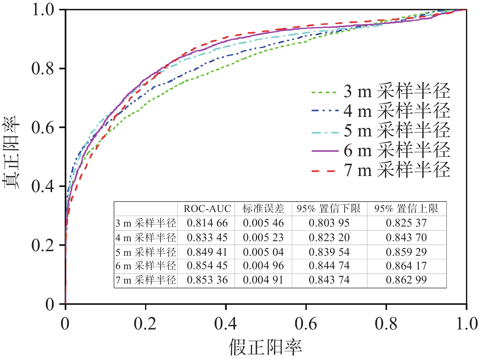
Hajian Tilaki Karimollah. Receiver operating characteristic (ROC) curve analysis for medical diagnostic test evaluation[J]. Caspian Journal of Internal Medicine, 2013, 4(2): 627-635.
|
Website Copyright © CARSOLOGICA SINICA 桂ICP备05009877号-1
Sponsor: Chinese Academy of Geological Sciences Sponsored by: Institute of Karst Geology, Chinese Academy of Geological Sciences Address: No.50, Qixing Road, Guilin, Guangxi
Post Code: 541004 Tel: 0773-5812949 7796657 Email: zgyrbjb@163.com
Supported by:
Beijing Renhe Information Technology Co., Ltd.


 DownLoad: