

Research on the characteristics and value of geological relics in the Enshi Grand Canyon-Tenglongdong Cave Global Geopark
-
摘要: 恩施地处云贵高原东北延伸部分,区域内广泛沉积碳酸盐岩,具有丰富的岩溶地貌景观,但地质遗迹资源能否达到申报世界地质公园的要求则十分关键。本文在实地调查的基础上,较为系统地分析了公园内地质遗迹的类型与发育特征,结合定性与定量评估的方法对地质遗迹进行综合评价,确定了恩施大峡谷−腾龙洞世界地质公园的边界范围。结果表明:(1)公园地处我国巨型地貌单元第二、三级阶梯过渡的斜坡地带,碳酸盐岩是造就该地区典型岩溶地貌的主因。(2)公园地质遗迹类型共分为3大类8类11亚类,以峰丛—洼地、峰林、孤峰、峡谷、石柱林、石芽、暗河、溶洞、天坑等岩溶地貌为主,以水体景观、地质剖面、古生物化石、地质灾害和地质构造为辅。(3)园区内有世界级地质遗迹2处,国家级地质遗迹14处,省级地质遗迹59处。恩施大峡谷、腾龙洞洞穴系统等地质遗迹,对研究青藏高原隆升及中国中部地貌响应,具有重要的科学价值和国际对比意义。公园地质遗迹种类丰富、代表性强,具备建设世界地质公园的资源禀赋,符合联合国教科文组织世界地质公园的标准和要求。Abstract:
Enshi is situated in the northeastern extension of the Yunnan–Guizhou Plateau, at the juncture of the Daba Mountain and the Wuling Mountains. This area is characterized by extensive deposits of carbonate rocks, which have resulted in highly distinctive and rich karst geological relics. Nevertheless, due to its remote location and inconvenient transportation, there has been little scientific research on this region,as well as a lack of systematic and professional studies,This study aims at conducting a comprehensive assessment of the geological relics within the Enshi Grand Canyon-Tenglongdong Cave Global Geopark and determining its boundary scope. By analyzing the scientific, popular science, and tourism development values of the geological relics within the park, this study provides a scientific basis for the planning and management of the geological park. It also promotes the rational utilization and effective protection of these geological relics. Based on the field surveys, this study systematically analyzed the types and development characteristics of the geological relics within the park. In accordance with "Investigation Specifications for Geological Relics" and "Technical Requirements and Work Guidelines for the Construction of National Geological Parks in China", and with reference to the existing research results on the evaluation of geological relics, an evaluation index system for the geological relics of the Enshi Grand Canyon-Tenglongdong Cave Global Geopark was constructed. A comprehensive evaluation was conducted on 77 geological relics within the park, combining both qualitative and quantitative assessments. The study outcomes elucidate several key points,(1) The park is situated in the transitional slope area between the second and third steps of China’s giant geomorphological units, with a significant hydraulic gradient. The extensive carbonate rocks within the park have been subjected to the long-term and intense effects of surface water and groundwater, resulting in the unique karst landscape of the region. (2) Geological relics within the park can be categorized into three major classes, eight subclasses, and eleven minor classes based on their origins, conditions, and functional roles. The main types include karst landscapes such as peak clusters and depressions, peak forests, isolated peaks, gorges, stone pillar forests, stone buds, underground rivers, caves, and sinkholes, supplemented by water features, geological profiles, paleontological fossils, geological disasters, geological structures, etc. (3) The Tenglongdong Cave system in Lichuan and the stone pillar forest in Enshi are world-class geological formations that represent the most internationally significant geological relics within the park. They are characterized by their typicality, rarity, and scientific significance. The bio-reef limestone in Jiantianba in Lichuan, the Chaodongyan Gorge in Enshi, the karst cave system of the Banqiao Underground River, the fissure of the Yunlong River, and 14 other sites are national-level geological relics that possess exceptional scientific and aesthetic value, ranking among the best in China. Additionally, Daweng Sinkhole and Tuanbao Black Cave in Lichuan, Gaojiatang Cave in Enshi, the stone buds and solution doline groups in Shibanling, along with 59 other sites, are classified as provincial-level geological relics, which are important components of the park. (4) The synergistic evolution of the terrestrial Enshi Grand Canyon, the subterranean Tenglongdong Cave system, and the multi-layered karst landforms within the park represents one of the best and most complete regional responses to the intermittent crustal uplift movements resulting from the uplift of the Qinghai–Xizang Plateau in Central China. This phenomenon holds significant scientific value and international relevance for the study of the Qinghai–Xizang Plateau’s uplift and the geomorphological responses in Central China. The formation and evolution of the swallet stream in Qingjiang offer essential insights into the formation of the Three Gorges of the Yangtze River over the past million years. Additionally, they shed light on the geomorphology and the spatial distribution of surface water and groundwater in Central China, holding significant comparative value in the field of international geological sciences. The park boasts a diverse array of geological relics and numerous distinctive characteristics. Prominent among these are the geological relics associated with carbonate rocks, including the swallet stream in Qingjiang, the system of Tenglongdong Cave, the Enshi Grand Canyon, and the stone pillar forest in Enshi. These geological relics not only exemplify significant scientific research value but also holds great potential for popularizing geological science and enhancing tourism development. In conclusion, the Enshi Grand Canyon-Tenglongdong Cave Geopark possesses the requisite resources to be designated as a Global Geopark and meets the standards and requirements established by UNESCO Global Geoparks. -
Key words:
- geopark /
- geological relics /
- karst landscape /
- research on geological value /
- Enshi
-
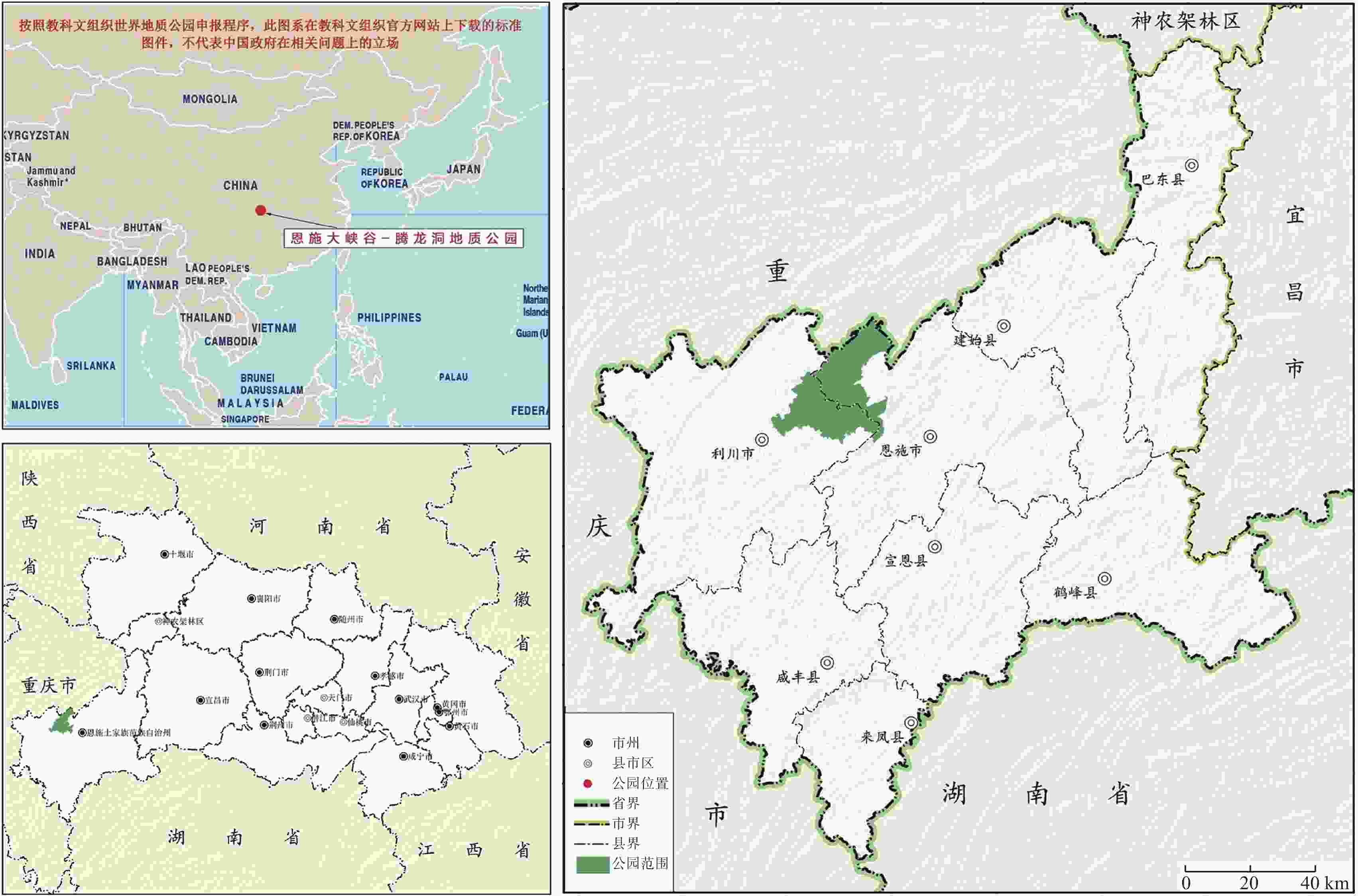
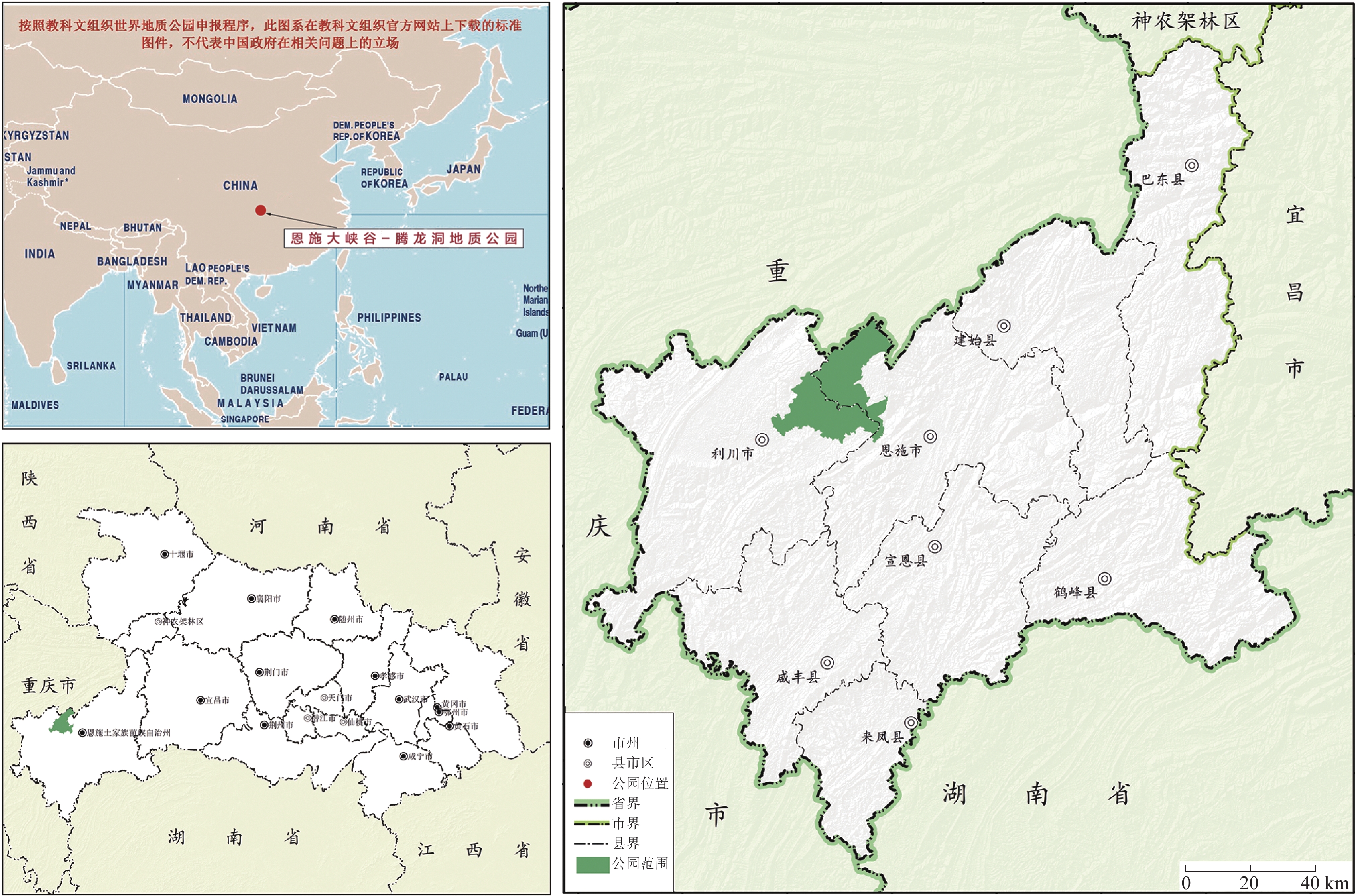
图 1 恩施大峡谷—腾龙洞世界地质公园区位图
Figure 1. Location of Enshi Grand Canyon–Tenglongdong Global Geopark
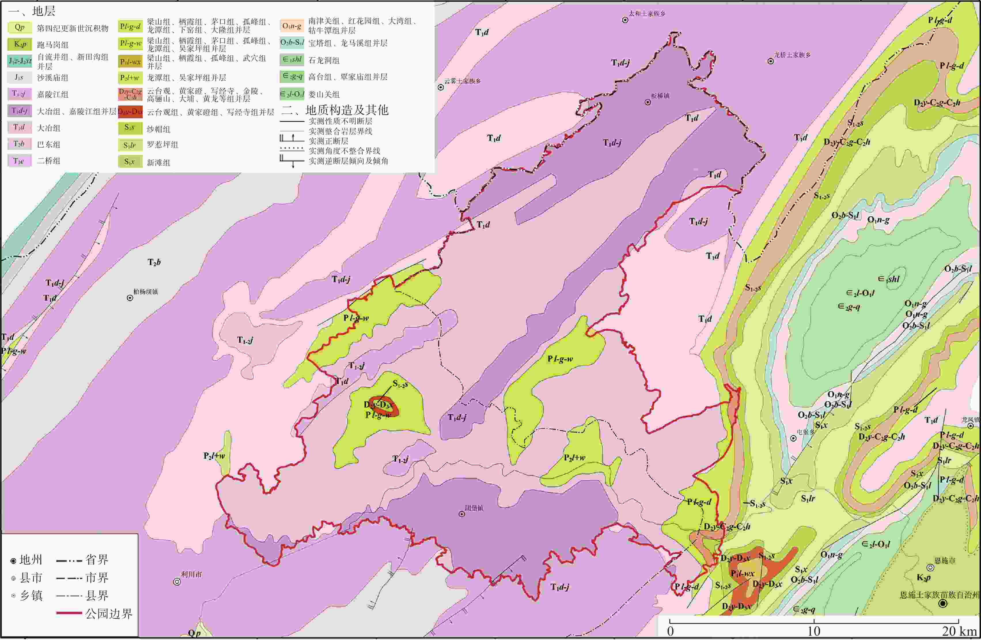
图 2 恩施大峡谷—腾龙洞世界地质公园地质图
Figure 2. Geology of Enshi Grand Canyon–Tenglongdong Global Geopark
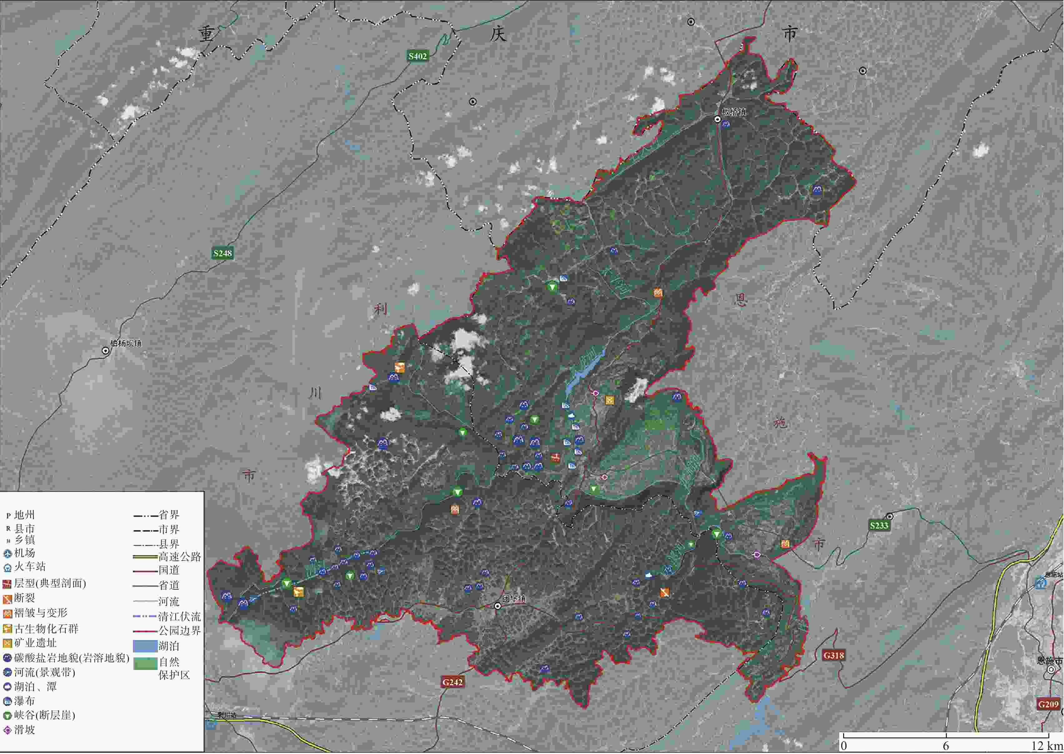
图 3 恩施大峡谷—腾龙洞世界地质公园地质遗迹分布图
Figure 3. Distribution of geological heritage in Enshi Grand Canyon–Tenglongdong Global Geopark
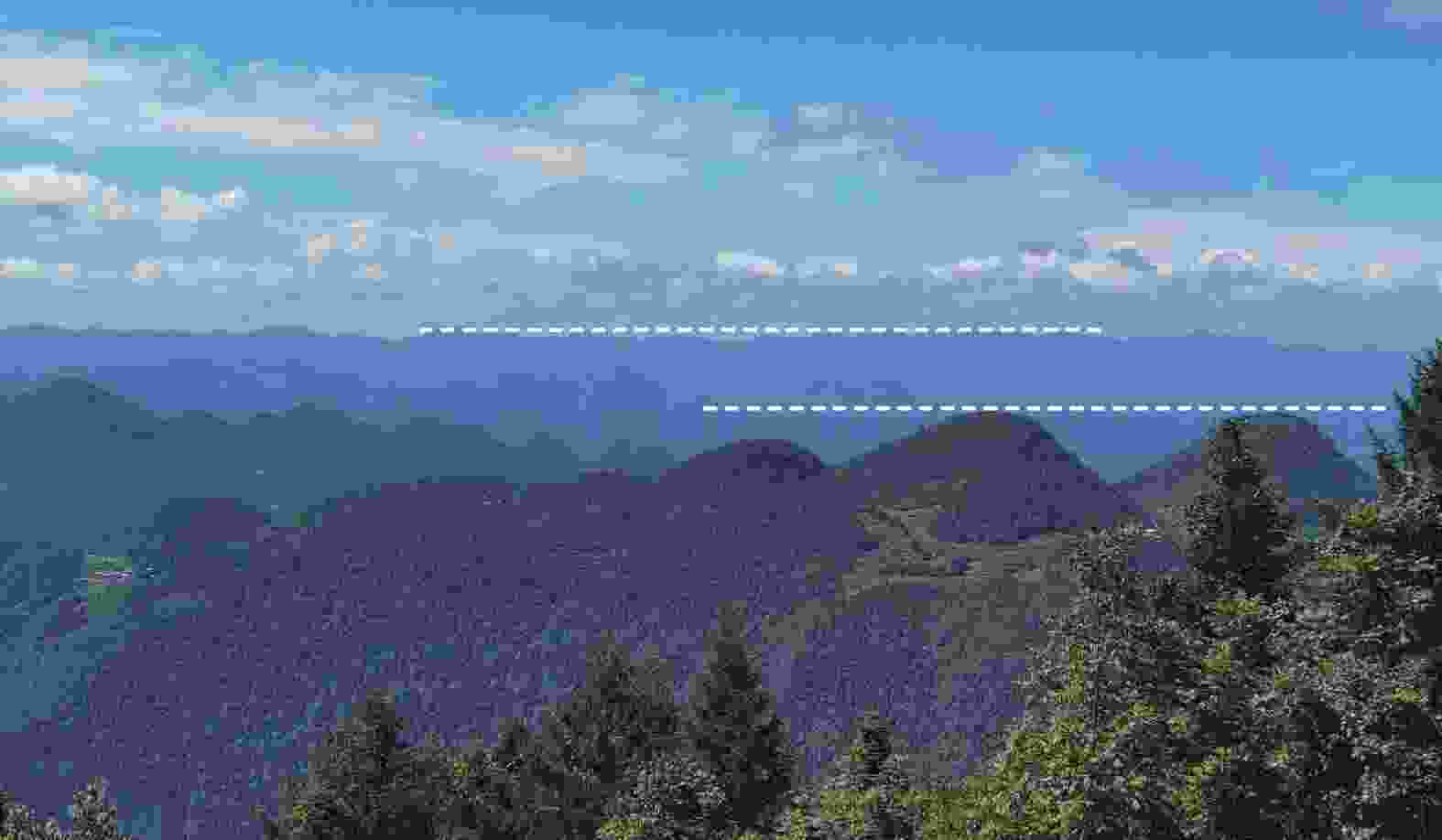
图 5 利川团堡峰丛地貌及不同岩溶台面(图中虚线为不同岩溶台面)
Figure 5. Geomorphology and different karst platform of Tuanbao peaks in Lichuan (The dotted lines in the figure are different karst platform)
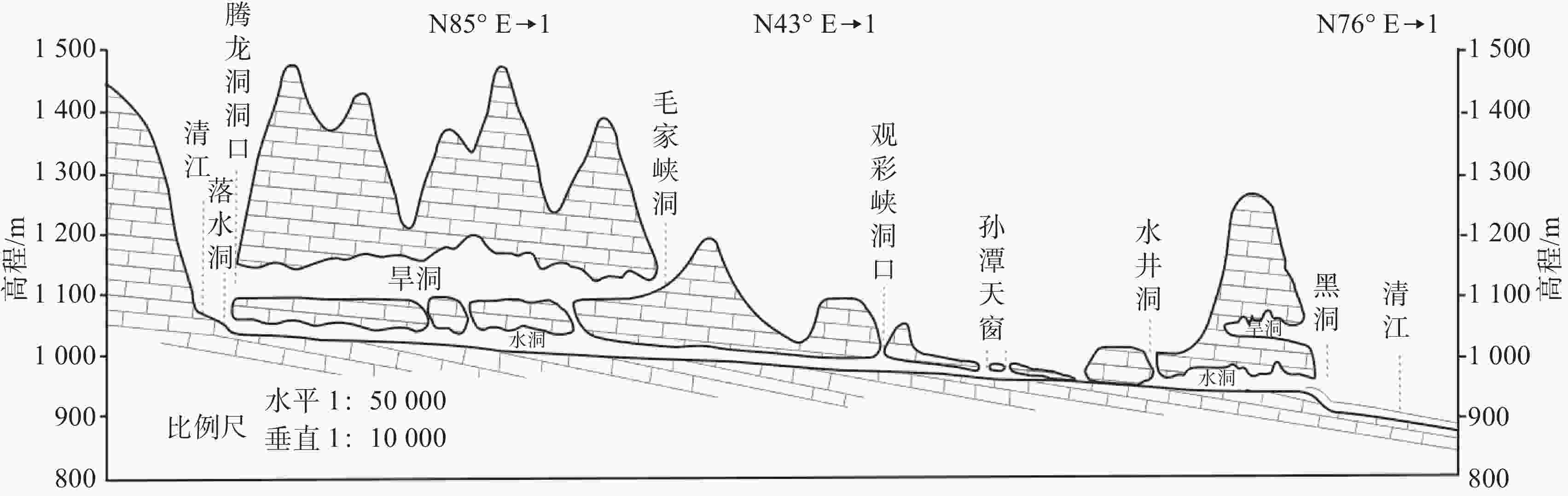
表 1 恩施大峡谷—腾龙洞世界地质公园地质遗迹分类
Table 1. Classification of geological heritage in Enshi Grand Canyon–Tenglongdong Global Geopark
大类 类 亚类 典型实例 数量 基础地
质大类地层剖面 层型(典型剖面) 二叠系-三叠系界线地层剖面 8 构造剖面 褶皱与变形 马者村褶皱地质构造、雪照河褶皱地质构造、恩施板桥复杂褶皱 断裂 建始-恩施断裂 重要化石产地 古生物化石产地 利川见天坝生物礁灰岩产地、龙骨洞大熊猫-剑齿象哺乳动物群化石产地 重要岩矿石产地 矿业遗址 沐抚煤矿遗址 地貌景
观大类岩土体地貌 碳酸盐岩地貌
(岩溶地貌)恩施石柱林、云龙河地缝、恩施板桥地下河岩溶洞穴系统、朝天笋、利川腾龙洞洞穴系统、利川团堡玉龙洞、利川东城穿洞群、利川多老河天坑等 66 水体地貌 河流(景观带) 恩施姚家坪河流景观、利川东城长堰槽干谷 湖泊、潭 云龙地缝月牙湖、利川团堡牛栏坪天鹅塘 瀑布 沐抚飞瀑、云龙瀑布、云龙地缝月牙湖、利川见天村瀑布、玄鹿飞瀑等 构造地貌 峡谷(断层崖) 恩施朝东岩大峡谷、恩施板桥鹿院坪峡谷、恩施沐抚令牌山构造地貌(峡谷)、利川雪照河峡谷、利川东城毛家峡等 地质灾害大类 地质灾害遗迹 滑坡 恩施沐抚古滑坡、恩施马者滑坡、恩施搬木村滑坡 3  下载: 导出CSV
表 2 腾龙洞与中国已探测岩溶洞穴对比(据文献[22]更新)
Table 2. Comparison between Tenglong cave and karst caves that have been explored in China (Updated based on literature [22])
序号 名称 位置 长度/m 1 双河洞 贵州绥阳 257400 2 三王洞 重庆武隆 67825 3 腾龙洞 湖北利川 59800 4 二王洞 重庆武隆 42139 5 天星洞穴系统 重庆武隆 38546 6 江州地下长廊 广西凤山 38500 7 麻王洞 贵州正安 34657 8 白水洞 贵州江口 22450 9 多缤洞 贵州修文 21100 10 聋子河洞 贵州镇远 20000 11 飞虎洞 湖南龙山 19000 12 穿岩洞 贵州安龙 17600 13 万佛长廊 贵州岑巩 16130 14 云门洞 贵州岑巩 15876 15 将军洞 贵州岑巩 13795 16 龙门洞 四川芦山 13190 17 织金洞 贵州织金 12100 18 马王洞 广西凤山 12000 19 格必河洞 贵州紫云 11896 20 高卢落水洞 贵州六枝特区 11761 21 金佛洞 重庆南川 11026 22 大洞 湖北五峰 10932 23 冠岩 广西桂林 10582 24 刺猪洞 贵州黔西 10557 25 三眼洞 重庆奉节 10484 26 新神洞 湖北松滋 10000 27 龙王洞 湖南石门 10000
下载: 导出CSV
表 3 腾龙洞与同类型世界地质公园岩溶洞穴对比
Table 3. Comparison between Tenglong cave and karst caves in the same type of global geoparks
地质公园名称 地点 洞穴类型和特征 恩施大峡谷—腾龙洞世界地质公园 湖北省恩施土家族苗族自治州利川市和恩施市境内 腾龙洞已探明通道总长达 59800 m,该洞穴为多层洞穴系统,地表为早期河流形成的槽谷、中间为旱洞(古地下伏流)、底部为现代地下伏流,并形成了29个支洞,18个天窗,旱洞宽40~100 m,高50~170 m;腾龙洞支洞保存有大量中更新世的大熊猫—剑齿象哺乳动物群化石,尤其是该区首次发现的第四纪灵长类动物化石为寻找古人类化石提供了重要线索织金洞世界地质公园 贵州省毕节市织金县和黔西县境内 织金洞已探测长度 4215 m,由2条主洞和4条支洞组成,洞内有苗岭大厅、水晶宫等13个洞穴大厅,洞穴总容积约600万m3;洞内次生沉积物规模宏大、类型齐全、造型独特,其中沉积物霸王盔、云雨树、石冻菌等在世界范围内具有多样性、独特性和稀有性;织金洞支洞保存有大量全新世扫尾豪猪排泄物和遗体残骸化石兴文世界地质公园 四川省宜宾市兴文县境内 天泉洞是兴文200多个洞穴中最著名的一个,洞道总长近 5000 m,体积约270万m3,该洞发育在二叠纪栖霞组灰岩中,受层间裂隙和北北西向节理的控制,呈多层次树枝状洞穴,由下而上可分为四层;现已开放第3、4层,共7个大厅;石花、石乳、石笋、石柱、石幔、石瀑布等洞内沉积物种类繁多房山世界地质公园 北京市房山区和河北省保定市涞水县、涞源县境内 房山溶洞群中最为典型的石花洞共有7层洞道,六、七层为地下暗河的流水及充水洞层;现已开发利用的一、二、三层洞道全长1900 m,洞底面积约 18000 m2,有12个洞厅及16个洞室;洞穴内石盾极其发育,石笋叠置关系显著,还有奇特的石旗和月奶石发育;石花洞保存有膜足硬肢马陆穴居动物化石乐业—凤山世界地质
公园广西壮族自治区百色市乐业县和河池市凤山县 凤山溶洞群中的江洲长廊发育在二叠系碳酸盐岩中,洞道长 38500 m,洞穴内发育多个塌陷天窗和竖井;洞穴内共有 25 个地下厅堂,面积在4000 ~18500 m2之间,其中8个大厅面积大于10000 m2;洞内有石笋、石柱、流石坝、石田等重力水沉积物以及卷曲石等非重力水沉积物越南董凡岩溶高原地质公园 越南河江省北部 董凡岩溶高原是越南缺水地区之一,在海拔 1150 m的马勒洞穴系统发现了一个水洞(Ong Cave),该洞长1679 m,洞口宽约50 m,高约25 m,具有显著的垂直发育特征,洞穴水平终止于一个竖井;洞内发育有石钟乳,大小从5 ~10 cm不等希腊柴尔莫斯—武拉伊科斯地质公园 希腊伯罗奔尼撒半岛北部 湖泊洞穴发育在白垩纪石灰岩中,洞穴长1 950 m,洞底面积为 20000 m2,该洞穴最大的特点是发育有13个连续的地下湖泊,它们位于不同的高度,这些湖泊是由缓慢的水流和水体停滞而形成;洞内石幔、石瀑布极其发育
下载: 导出CSV
表 4 恩施石柱林与其他地质公园石林对比
Table 4. Comparison of stone pillar forest and other stone forest of geopark in Enshi
地质公园名称 石林分布与形态特征 恩施大峡谷—腾龙洞世界地质公园 分布在三叠系嘉陵江组灰色碳酸盐岩中,单体形态呈柱状、笔状、塔状,高度多在70~150 m之间,岩柱径高指数大者仅为0.53,小者可达0.04。其中“一炷香”“玉笔峰”等单体石柱高度超过150 m,平均直径/高度比只有0.05 云南石林世界地质公园 分布在二叠系栖霞组和茅口组灰色碳酸盐岩中,单体形态以剑状为主,包括剑状、柱状、塔状、蘑菇状、锥状等,单体柱高5~14 m,宽度与高度之比最大为5.6,最小为0.56 湘西世界地质公园 分布在奥陶系大湾组和牯牛潭组红色碳酸盐岩中,单体形态包括塔状、墙状、柱状、锥状等,单体柱高一般在1~10 m;不同的单体叠加形成多种组合形态,叠加组合高度一般在5~30 m 河北涞源白石山国家地质公园 峰林为长城系高于庄组和蓟县系雾迷山组蚀变后的岩石经构造作用改造而形成;下部为肉红色的花岗岩基座,中、上部为白色大理岩,呈现“双层地质结构” 广西灌阳县文市石林地质公园 分布在泥盆系额头村组和石炭系尧云峰组、英塘组的灰色碳酸盐岩中,单体形态有剑状、刀脊状、柱状等,高度在3~18 m(一般10~15 m),为典型剑状石林地貌 贵州碧江石林地质公园 分布在寒武系清虚洞组灰色碳酸盐岩中,单体普遍高度在10~25 m,最高可达 35 m,柱体顶部呈尖塔状、剑尖状、刀尖状,下部呈椭圆柱状、棱柱状及不规则状
下载: 导出CSV
表 5 地质遗迹定量评价指标及权重
Table 5. Quantitative evaluation indexes and weights of geological relics
类型 一级指标 权重 二级指标 权重 地质遗迹 地质遗
迹价值0.71 典型性 0.12 稀有性 0.20 完整性(系统性) 0.09 科学价值 0.20 美学价值 0.18 科普价值 0.14 经济价值 0.07 地质遗迹
开发条件0.29 保存程度 0.19 可保护性 0.16 环境容量 0.22 交通状况 0.25 安全性 0.09 客源条件 0.09
下载: 导出CSV
表 6 地质遗迹定量评价标准
Table 6. Quantitative evaluation criteria for geological relics
一级指标 二级指标 评价内容 评价等级 ≥90 75~89 60~74 50~59 <59 价值评价 典型性 与省内、国内、世界对比 极典型 很典型 典型 较典型 普通 稀有性 与省内、国内、世界对比 极稀有 很稀有 稀有 一般 很一般 完整性(系统性) 形态的多样和丰富及完整 完好 好 较好 稍破坏 破坏严重 科学价值 在地学中的意义和科研价值 极高 很高 较高 一般 低 美学价值 艺术、造型、形态 极高 很高 较高 一般 不明显 科普价值 对教学、科普的意义 极高 很高 较高 一般 低 经济价值 旅游开发潜力 极高 很高 较高 一般 低 条件评价 保存程度 是否受到保护和利用 极好 很好 好 一般差 差 可保护性 其成因的可控制程度 易保护 能保护 可保护 不易 难 环境容量 正常情况的游客容纳数量 极大 很大 一般 较小 很小 交通状况 景观可通达性 便利 良好 一般 较差 差 安全性 地质稳定性、灾害隐患 很安全 安全 较安全 有不安全因素 有灾害隐患 客源条件 目前对游客的吸引力 极高 很高 较高 一般 低
下载: 导出CSV
表 7 地质遗迹定量评价结果
Table 7. Results of quantitative evaluation of geological relics
序号 地质遗迹 级别 序号 地质遗迹 级别 1 二叠系—三叠系界线地层剖面 省级 40 一龙门穿洞 省级 2 雪照河地质构造(天然画壁) 省级 41 二龙门穿洞 省级 3 马者村褶皱地质构造 省级 42 三龙门穿洞 省级 4 恩施板桥复杂褶皱(大冶灰岩中) 省级 43 一炷香 国家级 5 建始—恩施断裂 省级 44 古象岭 省级 6 利川见天坝生物礁灰岩产地 国家级 45 绝壁 省级 7 龙骨洞大熊猫—剑齿象哺乳动物群化石产地 国家级 46 祥云火炬 省级 8 沐抚煤矿遗址 省级 47 回音谷 省级 9 恩施石柱林 世界级 48 玉笔峰 国家级 10 利川见天坝生物礁石林 省级 49 玉女峰 国家级 11 利川太坪龙村石林 省级 50 玉屏峰 省级 12 利川响水洞天窗 省级 51 一线天 省级 13 利川东城银河洞 省级 52 独笋 省级 14 利川东城鲇鱼洞 省级 53 恩施沐抚办事处船桨山 省级 15 利川东城凉风洞 省级 54 恩施姚家坪河流景观 省级 16 利川东城穿洞群 省级 55 利川东城长堰槽干谷 省级 17 利川东城独家寨溶蚀峰丛鞍部 省级 56 利川团堡干河沟 省级 18 利川腾龙洞洞穴系统 世界级 57 云龙地缝月牙湖 省级 19 利川团堡玉龙洞 国家级 58 利川团堡牛栏坪天鹅塘 省级 20 利川团堡牯牛洞 市级 59 利川见天村瀑布 省级 21 利川团堡小溪河穿洞 省级 60 沐抚飞瀑 省级 22 利川团堡黑洞 省级 61 云龙瀑布 省级 23 利川团堡白洞 省级 62 云龙地缝—黄龙瀑布 省级 24 利川团堡深潭洞 省级 63 云龙地缝—彩虹瀑布 省级 25 利川团堡天窗 省级 64 冰瀑 省级 26 利川团堡筲箕天坑 省级 65 玄鹿飞瀑 省级 27 利川团堡龙头石 省级 66 恩施板桥鹿院坪峡谷 国家级 28 利川团堡仓洞 省级 67 恩施朝东岩峡谷 国家级 29 利川团堡小溪河(出水洞) 省级 68 恩施沐抚令牌山构造地貌(峡谷) 省级 30 恩施新田村穿洞 省级 69 恩施沐抚麦里峡谷 省级 31 恩施高家埫穿洞 省级 70 利川小溪河峡谷 市级 32 恩施板桥地下河岩溶洞穴系统 国家级 71 利川长扁河峡谷 省级 33 利川大瓮天坑 省级 72 利川雪照河峡谷 国家级 34 利川多老河天坑 省级 73 利川东城毛家峡 国家级 35 利川响水洞天坑 省级 74 利川东城观彩峡 省级 36 云龙河地缝 国家级 75 恩施搬木村滑坡 省级 37 恩施鹿院坪玄鹿地缝 省级 76 恩施马者滑坡 国家级 38 利川石板岭村石芽与溶沟群 省级 77 恩施沐抚古滑坡 省级 39 朝天笋 国家级
下载: 导出CSV
-
[1] 吴殿廷, 王欣, 刘宏红, 胡娟, 国权. 以世界自然遗产地为基础建设国家公园体系[J]. 自然与文化遗产研究, 2022, 7(5):61-70.WU Dianting,WANG Xin,LIU Honghong,HU Juan,WANG Guoquan. Building a National Park System Based on World Natural Heritage Sites[J]. Study on Natural and Cultural Heritage, 2022, 7(5): 61-70. [2] 后立胜, 许学工. 国家地质公园及其旅游开发[J]. 地域研究与开发, 2003, 22(5):54-57. doi: 10.3969/j.issn.1003-2363.2003.05.014HOU Lisheng, XU Xuegong. National Geopark and its Tourism Development[J]. Areal Research And Development, 2003, 22(5): 54-57. doi: 10.3969/j.issn.1003-2363.2003.05.014 [3] 赵逊, 赵汀. 从地质遗迹的保护到世界地质公园的建立[J]. 地质论评, 2003, 49(4):389-399. doi: 10.3321/j.issn:0371-5736.2003.04.009ZHAO Xun, ZHAO Ting. The Process from the Geoheritage Conservation to the Construction of World Geoparks[J]. Geological Review, 2003, 49(4): 389-399. doi: 10.3321/j.issn:0371-5736.2003.04.009 [4] Ding H, Li X N, Dai J W, Xue Y. Spatial Distribution of UNESCO Global Geoparks in China and Its Influencing Factors[J]. International journal of design & nature andecodynamics, 2020, 15(1): 47-55. [5] Xu K, Wu W. Geoparks and Geotourism in China: A Sustainable Approach to Geoheritage Conservation and Local Development—A Review[J]. Land, 2022, 11: 1493. doi: 10.3390/land11091493 [6] Watanabe M. The Origin and Development of Geoparks in Japan: Reflections from a Personal Perspective[J]. Geomorphological, 2018, 87-94. [7] 张建平. 世界地质公园的前世今生[J]. 地质论评, 2020, 66(6):27-30.ZHANG Jianping. History of UNESCO Global Geopark[J]. Geological Review, 2020, 66(6): 27-30. [8] 皮鹏程, 曾敏, 黄长生, 师环环,侯清芹,彭红霞. 基于SWOT-AHP模型的恩施州森林康养旅游可持续发展研究[J]. 华中师范大学学报(自然科学版), 2022, 56(1):127-139,115.PI Pengcheng, ZENG Min, HUANG Changsheng, SHI Huanhuan, HOU Qingqin, PENG Hongxia. A research on sustainable development of Enshi foresttherapy tourism based on SWOT-AHP model[J]. Journal Of Central China Normal University (Nat. Sci. ), 2022, 56(1): 127-139,115. [9] 王令占, 田洋, 涂兵, 曾波夫, 谢国刚. 鄂西利川齐岳山高陡背斜带的古应力分析[J]. 大地构造与成矿学, 2012, 36(4):490-503. doi: 10.3969/j.issn.1001-1552.2012.04.003WANG Lingzhan, TIAN Yang, TU Bing, ZENG Bofu, XIE Guogang. Paleostress Analysis of the Qiyue Shan High-angle Anticline in the Lichuan Area, Western Hubei Province, China[J]. Geotectonica et Metallogenia, 2012, 36(4): 490-503. doi: 10.3969/j.issn.1001-1552.2012.04.003 [10] Yang F, Ye J Z. The Structure Characteristics and the Shale Gas Exploration Potential of the Southeast Sichuan and Weatern Hubei and Hunan[M]. Wuhan: China University of Geosciences Press, 2011: 1-11. [11] 蒋忠诚, 李先琨, 曾馥平. 岩溶峰丛洼地生态重建[M]. 北京: 地质出版社, 2007: 1-2. [12] 夏凯生, 袁道先, 谢世友, 楚玉春. 乌江下游岩溶地貌形态特征初探:以重庆武隆及其邻近地区为例[J]. 中国岩溶, 2010, 29(2):197-204. doi: 10.3969/j.issn.1001-4810.2010.02.015XIA Kaisheng, YUAN Daoxian, XIE Shi you, CHU Yuchun. Preliminary study on morphology features of karst in the lower reaches of Wujiang River: A case in Wulong, Chongqing and the surrounding area[J]. Carsologica Sinica, 2010, 29(2): 197-204. doi: 10.3969/j.issn.1001-4810.2010.02.015 [13] 罗书文, 杨桃, 邓亚东, 覃星铭, 史文强, 韦跃龙, 李成展. 云贵川鸡鸣三省峡谷景观特征及形成机理研究[J]. 西南师范大学学报(自然科学版), 2018, 43(2):49-56.LUO Shuwen, YANG Tao, DENG Yadong, QIN Xingming, SHI Wenqiang, WEI Yuelong, LI Chengzhan. On Landscape Characteristic and Formation Mechanism of Yunguichuan Big Valley[J]. Journal of Southwest China Normal University(Natural Science Edition, 2018, 43(2): 49-56. [14] 韦跃龙, 李成展, 陈伟海, 吴忠,罗劬侃,翟秀敏,白冰. 重庆奉节天坑地缝景区岩溶景观特征及其形成演化分析[J]. 地球学报, 2019, 40(5):747-766. doi: 10.3975/cagsb.2019.052801WEI Yuelong, LI Chengzhan, CHEN Weihai, WU Zhong, LUO Qukan, ZHAI Xiumin, BAI Bing. Characteristics and Formation and Evolution Analysis of the Karst Landscape of Fengjie Tiankeng Difeng Scenic Area, Chongqing[J]. Acta Geoscientica Sinica, 2019, 40(5): 747-766. doi: 10.3975/cagsb.2019.052801 [15] 肖家魁, 张军. 雄奇大峡谷:湖北清江源地质公园恩施大峡谷园区探秘[J]. 资源环境与工程, 2007, 21(3):352-353. doi: 10.3969/j.issn.1671-1211.2007.03.033 [16] 康全国, 陈小龙, 赵璧. 鄂西南岩溶地貌遗迹类型与特征分析[J]. 华南地质与矿产, 2019, 35(4):472-480.KANG QuanGuo, CHEN XiaoLong, ZHAO Bi. Types and Characteristics of Karst Geomorphological Relics in Southwest Hubei Province[J]. Geology and Mineral Resources of South China, 2019, 35(4): 472-480. [17] 刘定学, 金兴红. 震撼! 腾龙洞:湖北清江源地质公园腾龙洞景区[J]. 资源环境与工程, 2007, 21(3):354-355. doi: 10.3969/j.issn.1671-1211.2007.03.034 [18] 董炳维. 腾龙洞洞穴系统及其开发价值[J]. 中国岩溶, 1987, 6(4):323-327.DONG Bingwei. Tenglongdong cave system and its value In development[J]. Carsologica Sinica, 1987, 6(4): 323-327. [19] 胡明毅, 魏欢, 邱小松, 赵恩璋. 鄂西利川见天坝长兴组生物礁内部构成及成礁模式[J]. 沉积学报, 2012, 30(1):33-42.HU Mingyi, WEI Huan, QIU Xiaosong, ZHAO Enzhang. Reef composition and their forming models of Changxing formation in jiantianba section of Lichuan, Western Hubei[J]. Acta Sedimentologica Sinica, 2012, 30(1): 33-42. [20] 李阳, 吴亚生, 姜红霞. 湖北利川二叠纪生物礁的埋藏学特征及其环境意义[J]. 古生物学报, 2018, 57(2):212-227.LI Yang, WU Yasheng, JIANG Hongxi. Taphonomic characteristics of a permian calcispongereef in Lichuan, Hubei province and its paleoenvironmental significance[J]. Acta Palaeontologica Sinica, 2018, 57(2): 212-227. [21] 王兴贵, 税伟, 陈毅萍, 兰肖雄. 兴文岩溶与中国南方岩溶旅游资源对比研究[J]. 中国岩溶, 2017, 36(2):255-263. doi: 10.11932/karst20170214WANG Xinggui, SHUI Wei, CHEN Yiping, LAN Xiaoxiong. Comparison between the Xingwen karst area and South China karst region on tourism resources[J]. Carsologica sinica, 2017, 36(2): 255-263. doi: 10.11932/karst20170214 [22] 张远海, 朱德浩. 中国大型岩溶洞穴空间分布及演变规律[J]. 桂林理工大学学报, 2012, 32(1):20-28. doi: 10.3969/j.issn.1674-9057.2012.01.003ZHANG Yuanhai,ZHU Dehao. Large Karst Caves Distribution and Development in China[J]. Journal of Guilin University of Technology, 2012, 32(1): 20-28. doi: 10.3969/j.issn.1674-9057.2012.01.003 [23] 李德文, 崔之久, 刘耕年. 青藏高原古岩溶的存在及其与东邻地区岩溶的对比[J]. 中国岩溶, 1999, 18(4):309-318. doi: 10.3969/j.issn.1001-4810.1999.04.003LI Dewen, CUI Zhijiu, LIU Gengnian. Existence of palaeokarst on tibet plateau and Its correlation with the karst of the eastern district[J]. Carsologica sinica, 1999, 18(4): 309-318. doi: 10.3969/j.issn.1001-4810.1999.04.003 [24] 高全洲, 崔之久, 刘耕年, 伍永秋, 张叶春. 晚新生代青藏高原岩溶地貌及其演化[J]. 古地理学报, 2001, 3(1):86-90. doi: 10.7605/gdlxb.2001.01.009GAO Quanzhou, CUI Zhijiu, LIU Gengnian, WU Yongqiu, ZHANG Yechun. Late cenozoic karst landforms on Qinghai-tibet plateau and their evolution[J]. Journal of Palaeogeography, 2001, 3(1): 86-90. doi: 10.7605/gdlxb.2001.01.009 [25] 郭汝军, 魏传义, 李长安, 张玉芬, 李亚伟, 孙习林, 张增杰, 冷勇辉, 苏建超, 李国鼐, 吕凌云, 陈旭, 丁智强. 长江演化百年谜题: 回溯与进展[J]. 地震地质, 2023, 45(1):1-28. doi: 10.3969/j.issn.0253-4967.2023.01.001GUO Rujun, WEI Chuanyi, LI Changan, ZHANG Yufen, LI Yawei, SUN Xilin, ZHANG Zengjie, LENG Yonghui, SU Jianchao, LI Guonai, LÜ Lingyun, CHEN Xu, DING Zhiqiang. A centennial puzzle of the evolution of the yangtze river: retrospection and progresses[J]. Seismology and Geology, 2023, 45(1): 1-28. doi: 10.3969/j.issn.0253-4967.2023.01.001 [26] 王延奇, 胡明毅, 刘富艳, 等. 鄂西利川见天坝长兴组海绵礁岩石类型及礁体演化阶段[J]. 岩性油气藏, 2008, 20(3):44-48. doi: 10.3969/j.issn.1673-8926.2008.03.009WANG Yanqi, HU Mingyi, LIU Fuyan, WANG Hui, HU Zhihua. Rock types and evolution of reef of Changxing Formation in Jiantianba of western Hubei[J]. Lithologic Reservoirs, 2008, 20(3): 44-48. doi: 10.3969/j.issn.1673-8926.2008.03.009 [27] 世界旅游联盟旅游减贫案例2018[R]. 2018, World Tourism Alliance. [28] 薛滨瑞, 彭永祥, 张立文. 陕西延川黄河蛇曲国家地质公园地质遗迹特征与旅游开发价值[J]. 地球学报, 2011, 32(2):217-224. doi: 10.3975/cagsb.2011.02.11XUE Binrui, PENG yongxiang, ZHANG Liwen. Geosite Features and Tourism Values of the Yellow River Meanders National Geopark in Yanchuan County, Shaanxi Province[J]. Acta Geoscientica Sinica, 2011, 32(2): 217-224. doi: 10.3975/cagsb.2011.02.11 [29] 肖景义, 候光良, 唐仲霞, 张玉珍, 祝佳甲. 青海省贵德国家地质公园地质遗迹及综合评价[J]. 地球学报, 2013, 34(1):111-120. doi: 10.3975/cagsb.2013.01.11XIAO Jingyi, HOU Guangliang, TANG Zhongxia, ZHANG Yuzhen, ZHU Jiajia. A Comprehensive Evaluation of Geoheritages in Guide National Geopark of Qinghai Province[J]. Acta Geoscientica Sinica, 2013, 34(1): 111-120. doi: 10.3975/cagsb.2013.01.11 [30] 王铠铭, 武法东, 张建平. 北京延庆地质公园主要地质遗迹评价[J]. 地球学报, 2013, 34(3):361-369. doi: 10.3975/cagsb.2013.03.12WANG Kaiming, WU Fadong, ZHANG Jianping. Assessment of Major Geoheritages in the Yanqing Geopark of Beijing[J]. Acta Geoscientica Sinica, 2013, 34(3): 361-369. doi: 10.3975/cagsb.2013.03.12 [31] 费玲玲, 牛漫兰, 朱洪, 等. 基于AHP法地质遗迹资源定量评价及其应用研究[J]. 合肥工业大学学报(自然科学版), 2017, 40(7):971-977.FEI Lingling, NIU Manlan, ZHU Hong, ZHANG Chengyun, GUO Chuanhui. Quantitative evaluation of geological relic resources based on AHP and its application[J]. Journal of Hefei University of Technology, 2017, 40(7): 971-977. [32] 罗书文, 杨桃, 邓亚东, 覃星铭. 毕节鸡鸣三省·贵州地质公园地质遗迹特征及价值研究[J]. 中国岩溶, 2019, 38(6):946-956. doi: 10.11932/karst2019y13LUO Shuwen, YANG Tao, DENG Yadong, QIN Xingming. Characteristics and value of geological relics in the Bijie Jiming Sansheng·Guizhou geopark[J]. Carsologica Sinica, 2019, 38(6): 946-956. doi: 10.11932/karst2019y13 [33] 许基伟, 方世明, 黄荣华. 广西大化七百弄国家地质公园地质遗迹资源评价及地学意义[J]. 山地学报, 2017, 35(2):221-229.XU Jiwei, FANG Shiming, HUANG Ronghua. Evaluation of Geological Relic Resources of Dahua Qibailong National Geopark in Guangxi and Its Scientific Significance[J]. Mountain Research, 2017, 35(2): 221-229. -


 点击查看大图
计量
- 文章访问数: 523
- HTML浏览量: 182
- PDF下载量: 58
- 被引次数: 0
