

Classification of groundwater systems and system characteristics in the Datang synclinal area of north Guizhou
-
摘要: 黔北大塘向斜区含水系统尚未开展地下水系统划分的相关工作,区内分布多个铝土矿区,铝土矿为顶板直接充水的岩溶充水矿床,岩溶水文地质条件极其复杂,给区域内铝土矿水文地质特征的客观评价带来了一定难度。文章通过对黔北大塘向斜区地下水系统研究,收集并整理了历史水文地质资料,结合水文地质调查,系统地分析了研究区和地下水系统边界及水文地质和动态特征。结果表明:(1)研究区具有相对独立的地下水系统,具有较完整的补径排条件,主要为地下河系统和分散排泄系统;(2)将研究区划分为2个地下水系统,即大塘向斜地下河系统和洛龙背斜分散排泄系统。研究成果为区域铝土矿开发的水文地质风险评估及地下水资源管理提供了科学依据。Abstract:
In recent years, researchers have conducted various studies on the classification of groundwater systems and have summarized different methods of this classification. Investigations into groundwater system division and system characteristics have been carried out in several areas of karst mountainous areas in Southwest China. Notably, Guizhou Province has extensively conducted 1: 50000 hydrogeological surveys; however, there has been no research focused on the classification of groundwater systems within the water-bearing system of the Datang Syncline Area in North Guizhou. This area is characterized by multiple bauxite exploration rights, and bauxite is known to be a karst water-filled deposit that is directly replenished by roof water. The karst hydrogeological conditions are extremely complex, which poses certain difficulties for the objective evaluation of the hydrogeological characteristics of bauxite in this area. This study provides an objective evaluation of the regional hydrogeological characteristics by examining the groundwater system in the Datang Syncline Area of North Guizhou. It mainly uses hydrogeological survey data collected from the study area, supplemented by on-site hydrogeological surveys, results of water quality analysis, and long-term observations of groundwater dynamics. This comprehensive analysis aims to delineate the boundaries and characteristics of the groundwater system in the area.The research findings indicate that the Datang Syncline Area in North Guizhou has a relatively independent groundwater system characterized by relatively complete recharge, runoff, and discharge conditions. This system mainly consists of underground river systems and dispersed discharge systems. The study area is divided into two groundwater systems, namely, the Datang synclinal underground river system and the Luolong anticline dispersed discharge system. The characteristics of each system are described. The water-bearing medium of the Datang synclinal underground river system consists of fissure–cave and cave–pipeline formations. The groundwater depth typically ranges from 50 m to 250 m. Except for the watershed in the southwest, the remaining boundaries are delineated by the aquitard of the Hanjiadian Group within the Zhiliu System. There are 392 surface karst features in the system, including sinkholes, inlets and outlets of underground rivers, and karst funnels. The system is mainly composed of underground river pipelines, with a total of seven main underground rivers. Among these, two larger underground rivers, S17 and S22, are located north of the Luolong River and are considered the main underground rivers in the system. The underground rivers S18, S19, S20, K1, and K2 are developed south of the Luolong River. The Datang synclinal underground river system characterized by a centralized injection supply, concentrated runoff through karst pipelines, and centralized discharge from underground river outlets. In the area north of the Luolong River, groundwater typically flows from north to south, whereas in the southern area, groundwater flows from southwest to northeast. The aquifer medium of dispersed drainage system of the Luolong Anticline is mainly composed of joint fissures. The boundary of the system is delineated as follows: the surface watershed to the northwest, the aquitard of Silurian Hanjiadian Group to the south and east, and the surface watershed to the west. This system is characterized by surface infiltration recharge, joint fissure runoff, and dispersed discharge through springs. The overall direction of groundwater runoff is from north to south. The dynamic changes in water flow are consistent with rainfall variations, and the dynamic changes of groundwater are relatively stable. The chemical type of groundwater is HCO$_3^{-}$- Ca2+. Compared with the dry season, the content of Ca2+ in surface water during the wet season decreases, primarily due to dilution by rainstorm. The increase of HCO$_3^{-}$- is relatively small, mainly because atmospheric precipitation during the rainstorm absorbs high concentration of CO2 from soil and fallen leaves during the surface runoff process, which subsequently leads to chemical reactions. The research findings provide a basis for objectively evaluating the hydrogeological characteristics of bauxite and the regional groundwater resources in the study area. -
Key words:
- groundwater system /
- boundary features /
- dynamic changes /
- Datang syncline /
- North Guizhou
-
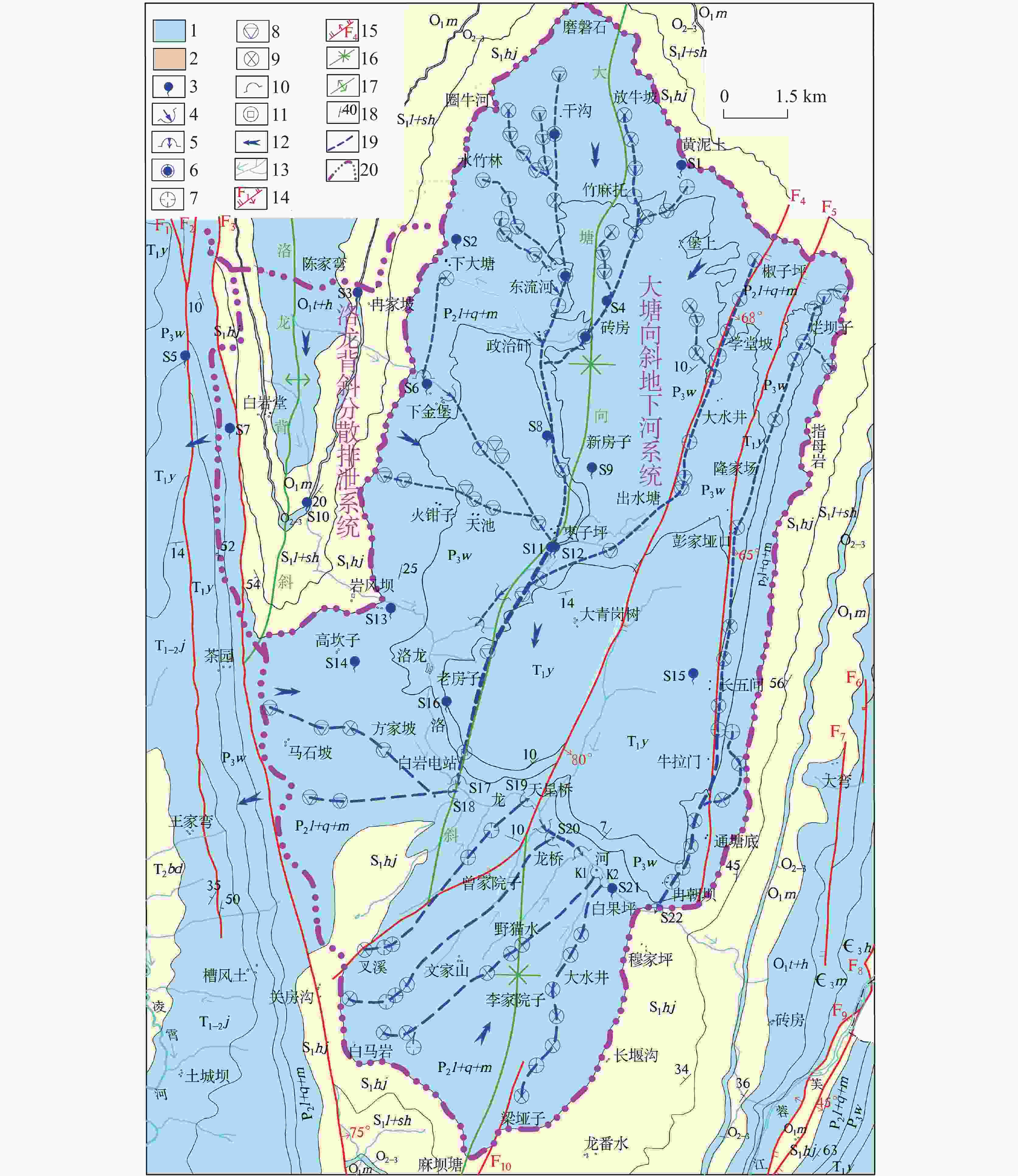
图 1 水文地质略图(据文献[20]修改)
1-碳酸盐岩岩溶含水岩组 2-碎屑岩裂隙含水岩组 3-下降泉 4-地下河入口 5-地下河出口 6-地下河天窗 7-岩溶洼地 8-岩溶漏斗 9-落水洞 10-出水溶洞 11-岩溶竖井 12-地下水流向 13-河流溪沟及流向 14-正断层 15-逆断层 16-向斜轴线 17-背斜轴线 18-地层产状 19-地下河管道 20-地下水系统边界
Figure 1. Hydrogeological sketch (modified according to reference [20])
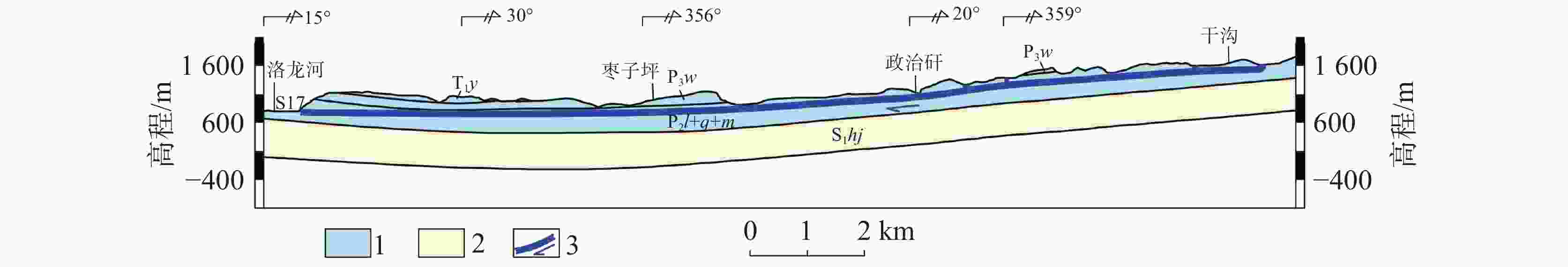
图 2 S17地下河纵剖面示意图
1-碳酸盐岩岩溶含水岩组 2-碎屑岩裂隙含水岩组 3-地下河及走向
Figure 2. Schematic diagram of longitudinal section of underground river S17
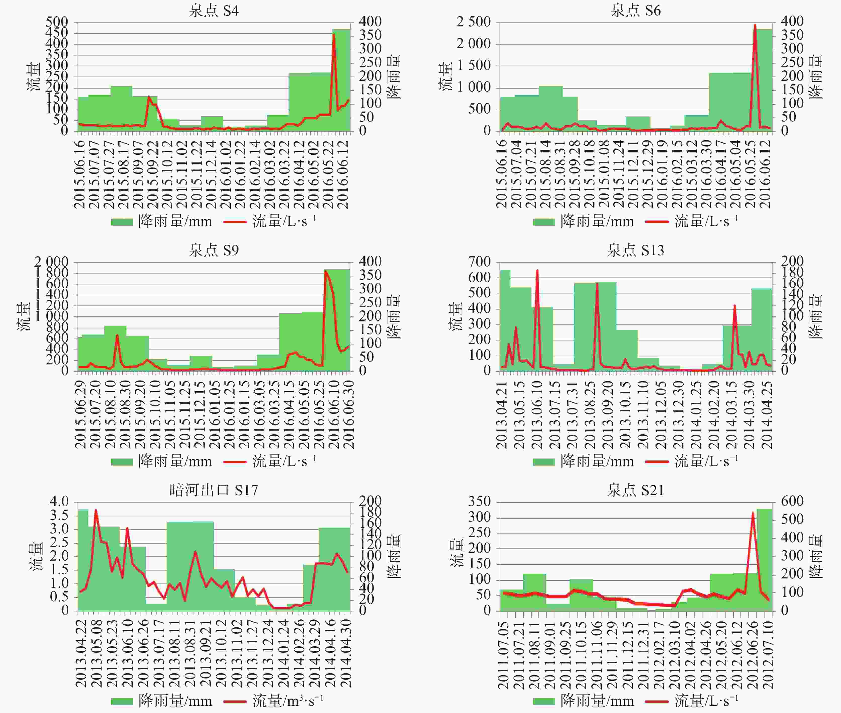
图 3 典型地下水排泄点流量动态变化与降雨量关系图
Figure 3. Relationship between dynamic changes in flow at typical discharge points and rainfall
表 1 典型地下水排泄点动态变化统计表
Table 1. Statistics of dynamic changes in typical groundwater discharge points
排泄点编号 S17 S13 S21 S6 S4 S9 丰水期平均流量/L∙s−1 1350 69.83 66.16 155 53.82 248.81 枯水期平均流量/L∙s−1 190 12.36 33.43 45 12.29 32.89 丰枯变幅系数/L∙s−1 7.11 5.65 1.98 3.44 4.38 7.57 观测期 最大流量/L∙s−1 3710 649.83 315.15 2440 446.57 1834.8 最小流量/L∙s−1 103 5.7 18.19 20 7.36 27.56 平均流量/L∙s−1 1150 54.90 54.93 121 40.53 177.82 极平变幅系数(倍) 3.23 11.84 5.74 20.17 11.02 10.32 极值变幅系数(倍) 36.02 114 17.33 122 60.68 66.57  下载: 导出CSV
表 2 水样中主要离子浓度统计表(单位:mg∙L−1)
Table 2. Statistics of main ion concentrations in water samples (unit: mg∙L−1)
取样地点 K+ Na− Ca2+ Mg2+ Cl− ${\rm{SO}}_4^{2-}$ ${\rm{HCO}}_3^{-}$ ${\rm{CO}}_3^{2-}$ S6 0.74 2.02 27.78 2.26 3.97 17.17 84.37 0.00 S9 0.68 0.44 25.54 2.98 1.78 7.16 73.99 0.00 S13 0.4 0.44 43.22 3.40 1.08 11.61 126.25 0.00 S17 0.63 3.85 90.38 2.98 3.59 2.68 273.54 0.00 S21 0.33 1.67 65.76 3.67 6.61 14.00 182.32 0.00 东流河 丰水期 0.49 0.37 36.94 3.46 1.74 8.34 111.78 0.00 枯水期 0.33 0.44 38.30 2.00 2.07 11.00 117.63 0.00 洛龙河 丰水期 0.7 5.68 34.81 1.70 1.39 20.04 110.06 0.00 枯水期 0.76 1.83 47.93 2.24 3.50 18.03 131.05 0.00
下载: 导出CSV
-
[1] 中国地质调查局. 地下水系统划分导则(GWI-A5)[M ]. 北京: 地质出版社, 2004. [2] 孙厚云, 毛启贵, 卫晓锋,张会琼,葸玉泽. 哈密盆地地下水系统水化学特征及形成演化[J]. 中国地质, 2018, 45(6): 1128-1141.SUN Houyun, MAO Qigui, WEI Xiaofeng, ZHANG Huiqiong, XI Yuze. Hydrogeochemical characteristics and formation evolutionary mechanism of the groundwater system in the Hami basin[J].Geology in China, 2018, 45 (6): 1128-1141. [3] 潘晓东, 梁杏, 唐建生, 苏春田, 孟小军. 黔东北高原斜坡地区4种岩溶地下水系统模式及特点:基于地貌和蓄水构造特征[J]. 地球学报, 2015, 36(1):85-93. doi: 10.3975/cagsb.2015.01.10PAN Xiaodong, LIANG Xing, TANG Jiansheng, SU Chuntian, MENG Xiaojun. The Patterns and Characteristics of Four Karst Groundwater Systems in Northeast Guizhou Slope Zone Based on the Landscape and Reservoir Structure[J]. Acta Geoscientica Sinica, 2015, 36(1): 85-93. doi: 10.3975/cagsb.2015.01.10 [4] 赵一, 李衍青, 李军, 刘鹏, 蓝芙宁. 滇东断陷盆地南洞岩溶地下水系统地下河水文动态特征与资源量评价[J]. 地球学报, 2021, 42(3):324-332. doi: 10.3975/cagsb.2020.091601Zhao Yi, Li Yanqing, Li Jun, LIU Peng, LAN Funing. Underground River Hydrological Dynamic Characteristics and Resource Evaluation of the Nandong Karst Water System in East Yunnan Faulted Basin[J]. Acta Geoscientica Sinica, 2021, 42(3): 324-332. doi: 10.3975/cagsb.2020.091601 [5] 林永生, 杜毓超, 邹胜章, 樊连杰,全洗强. 重庆市金佛山台原岩溶地下水系统结构特征分析[J]. 中国岩溶, 2020, 39(5): 658-664.LIN Yongsheng, DU Yuchao, ZOU Shengzhang, FAN Lianjie, QUAN Xiqiang.Structural characteristics of karst groundwater system beneath Jinfoshan, Nanchuan district, Chongqing City[J].Carsologica Sinica, 2020, 39 (5): 658-664. [6] 莫美仙, 王宇, 李峰, 虞慧. 云南南洞地下河系统边界及性质 研究[J]. 中国岩溶, 2019, 38(2): 173-185.MO Meixian, WANG Yu, LI Feng, YU Hui.Study on the boundaries and properties of the underground river system in Nandong,Yunnan Province[J]. Carsologica Sinica, 2019, 38 (2): 173-185. [7] 杨会峰, 王贵玲, 张翼龙. 中国北方地下水系统划分方案研究[J].地学前沿(中国地质大学(北京);北京大学), 2014,21(4): 74-82.,YANG Huifeng, WANG Guiling, ZHANG Yilong.A division scheme of groundwater systems in North China[J].Earth Science Frontiers(China University of Geosciences(Beijing);Peking University), 2014,21 (4): 74-82. [8] 陈梦熊, 马凤山. 中国地下水资源与环境[M ]. 北京: 地震出版社, 2002. [9] 裴建国, 梁茂珍, 陈阵. 西南岩溶石山地区岩溶地下水系统划分及其主要特征值统计[J].中国岩溶, 2008, 27(1): 6-10.PEI Jianguo, LIANG Maozhen, CHEN Zhen. Classification of karst groundwater systems and statistics of the main characteristic values in southwestern China Karst mountainous[J].Carsologica Sinica, 2008, 27 (1): 6-10. [10] 王明章, 陈萍、王中美. 贵州省岩溶地下水系统及地下水赋存规律研究[M ]. 北京: 地质出版社, 2018. [11] 龙胜实, 罗林,等. 贵州省含水岩组及岩溶流域划分专题研究报告[R]. 贵州省地质矿产勘查开发局111地质大队, 2015. [12] 杨 杨, 赵良杰, 夏日元, 王莹. 珠江流域岩溶地下河分布特征与影响因素研究[J]. 中国岩溶, 2022, 41(4): 562-576.YANG Yang, ZHAO Liangjie, XIA Riyuan, WANG Ying.Distribution and influencing factors of karst underground rivers in the Pearl River Basin[J].Carsologica Sinica, 2022, 41 (4): 562-576. [13] 潘玉峰, 吴建标, 李社宏, 潘明. 滇东南南洞地下河系统源区洞穴特征及其成因演化机制[J]. 中国岩溶, 2022, 41(1):133-142. doi: 10.11932/karst20220107PAN Yufeng, WU Jianbiao, LI Shehong, PAN Ming. Cave characteristics and its genesis and evolution in the source area of Nandong underground river system in Nandong area, Southeast Yunnan[J]. Carsologica Sinica, 2022, 41(1): 133-142. doi: 10.11932/karst20220107 [14] 韩 凯, 梁东辉, 甘伏平, 黄芬. 利用高精度示踪技术和大功率充电法确定地下河系统的管道分布特征: 以毛村地下河系统为例[J]. 中国岩溶, 2021, 40(5):884-893. doi: 10.11932/karst20210513HAN Kai, LIANG Donghui, GAN Fuping. Utilizing high-precision tracer technology and high-powered mise-a-lamasse method to determine the pipeline distribution characteristics of underground river system: A case study in Maocun underground river system[J]. Carsologica Sinica, 2021, 40(5): 884-893. doi: 10.11932/karst20210513 [15] 易连兴, 夏日元, 唐建生, 时坚, 罗伟权, 陈阵.西南岩溶地下河流量重复统计问题及对策探讨[J].中国岩溶, 2015, 34(1): 72-78.YI Lianxing, XIA Riyuan, TANG Jiansheng, SHI Jian, LUO Weiquan, CHEN Zhen.Dealing with overestimates of underground river discharge in karst areas of southwestern China[J]. Carsologica Sinica, 2015, 34 (1): 72-78. [16] 王伟, 向群. 黔西北地区岩溶水系统划分及找水方向[J]. 贵州地质, 2010, 27(1): 49-53.Wang Wei, Xiang Qun. Division of Karst Water System and Water Prospecting Direction in Northwest Guizhou[J].Guizhou Geology, 2010, 27 (1): 49-53. [17] 王明章, 张林, 王伟,等. 贵州省岩溶区地下水及地质环境[R]. 2011. [18] 陈萍, 王明章. 基于地下水开发的岩溶地下水系统类型划分方案探讨[J].中国岩溶, 2015, 34(3): 6234-237.CHEN Ping, WANG Mingzhang.A classification scheme of karst groundwater systems based on groundwater exploitation[J]. Carsologica Sinica, 2015, 34 (3): 6234-237. [19] 王宇. 西南岩溶地区岩溶水系统分类、特征及勘查评价要点[J]. 中国岩溶, 2002, 21(2): 114-119.WANG Yu. Classification features of karst water system and key point for the evaluation to karst water exploration in southwest China karst area[J]. Carsologica Sinica, 2002, 21 (2): 114-119. [20] 侯江勇, 向通,等. 贵州省道真县大塘铝土矿详查报告[R]. 贵州省地质矿产勘查开发局117地质大队, 2018. [21] 侯江勇, 向通,等. 贵州省道真县洛龙铝土矿详查报告[R]. 贵州省地质矿产勘查开发局117地质大队, 2014. [22] 侯江勇, 向通,等. 贵州省务、正、道地区大塘向斜铝土矿整装勘查报告[R]. 贵州省地质矿产勘查开发局117地质大队, 2015. -


 点击查看大图
计量
- 文章访问数: 201
- HTML浏览量: 77
- PDF下载量: 48
- 被引次数: 0
