Records of glacier activities by the alpine travertine landform in the Yulongxi area along Gongga mountain
-
摘要: 文章选取贡嘎山西侧玉龙西断裂带附近的钙华及周边冰碛物为研究对象,在野外调查的基础上,通过卫星高光谱遥感数据进行钙华识别,对钙华进行航空摄影测量,并构建主要钙华体精细化DEM及三维模型,分析钙华分布规律及地貌特征。结果表明:研究区钙华集中分布于玉龙西区域南北向断裂带两侧,沟谷由高向低处延伸,部分残留钙华体长宽比及表面擦痕等形态特征符合鲸背石、羊背石的外观特点。根据XRD半定量测试结果,结合地形特征,推测覆盖于钙华体之上的堆积物可能是冰川活动的产物,冰川活动时期,上部杂谷脑组风化剥蚀的物质随着冰川作用搬运至钙华体之上,活跃的冰川活动导致早期钙华遭受强烈的冰川侵蚀作用,形成冰川侵蚀地貌。Abstract:
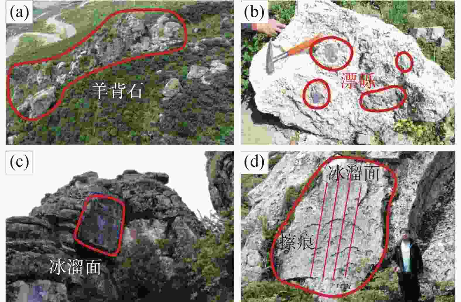
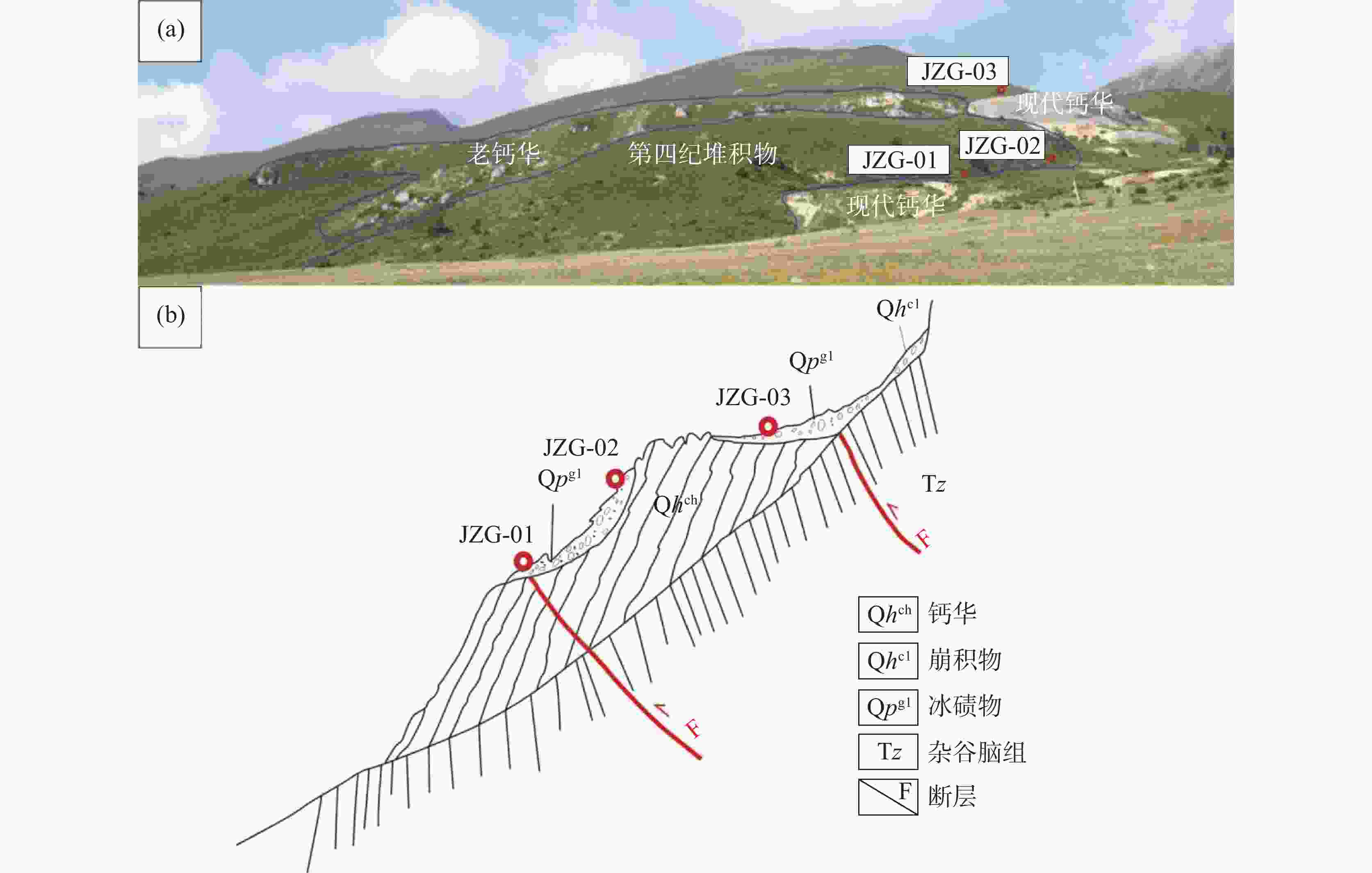
As a carrier of geological historical records and climatic information, travertine has played a crucial role in the study of global climate change, and scholars have made significant progress in research on travertine over the past few decades. Travertine deposits are widely distributed on the Qinghai-Tibet Plateau, often referred to as the "Third Pole in the World". They are especially distributed in high mountains along the eastern edge of the plateau, forming a belt of travertine from northeast to southwest. These travertine formations in the high-altitude regions are predominantly found above the Quaternary ancient glaciers, closely associated with the development and distribution of these glaciers. Hence, the travertine geomorphology in these high-altitude areas may serve as evidence of the Quaternary glacial activities. Therefore, aiming to provide evidence for the Quaternary glacier activities, this study selects surface-exposed travertine in the Yulongxi area on the western side of Gongga mountain as the research subject to analyze records of glacial activities in high-altitude travertine. The specific research methods employed in this study are as follows: (1) conducting field geological work to survey glacial landforms surrounding travertine, such as glacial striations, sheep back stones, etc., and collecting samples of moraines on and near the old travertine bodies; (2) utilizing GF-05 satellite hyperspectral remote sensing data to interpret the lithology of travertine developed in the fault zone of the Yulongxi area, thereby obtaining the distribution characteristics of travertine in the study area; (3) employing drones to perform low-altitude photogrammetric surveys on several typical travertine bodies in the study area, constructing refined DEMs and 3D models to analyze the distribution patterns and geomorphological characteristics of travertine, and combining terrain features to analyze the formation of sheep back stones and whalebacks; (4) using XRD testing technology to analyze the compositions of moraines and comparing the similarities and differences between the compositions of moraines deposited at different locations on the old travertine bodies; (5) integrating previous chronological data on travertine belts developed in the north-south direction on the eastern edge of the Qinghai-Tibet Plateau, and comprehensively discussing the potential records of glacial activities in travertine in the study area during the last Glacial Maximum. The research findings are summarized as follows. (1) Travertine in the study area is mainly distributed on both sides of the fault zone within the altitude range of 4,000 m to 4,500 m. Large travertine formations are more concentrated within a 200-meter elevation difference. Some residual travertine bodies are characterized morphologically by elongated shapes, surface striations, etc., consistent with the appearance of whalebacks and sheep back stone. (2) Based on XRD test results and terrain features, it is inferred that the deposits covering the travertine bodies are likely the products from glacial activities. During glacial periods, material weathered and eroded from the upper part of the Zagunao Formation was transported onto the travertine bodies through glacial action. Simultaneously, with the Quaternary glacier activities, early travertine formations underwent intense glacial erosion, forming glacial erosional landforms. Combining previous research on travertine and moraines in the Gongga mountain area, this study draws the following conclusions regarding the potential records of glacial activities during the last Glacial Maximum in the study area. During interstadial periods of the last Glacial Maximum, warming climate led to glacier melting and retreat. The melting of ice and snow, coupled with rainfall, provided favorable material conditions for the formation of travertine deposits in the study area. Meltwater and rainfall infiltrated down to lower elevations along synclines of the Zagunao Formation, upwelled along the fault in the Yulongxi area, overflowed near the fault and downstream valleys, and finally formed extensive travertine deposits. During glacial periods, the entire region was covered by glaciers. Under the pressure of the upper glaciers, bedrock debris entrained at the glacier base eroded and abraded the bedrock (travertine). Early travertine formations were eroded, forming glacial erosional landforms, with travertine fragments and bedrock debris covering the travertine bodies in some areas. With global warming and rising temperature, travertine growth ceased in most areas, due to the rapid retreat of glaciers and the reduction of precipitation and meltwater. Early glacially eroded travertine landforms were subjected to erosion and weathering by water flow, and some moraines remained on the top of old travertine bodies. -
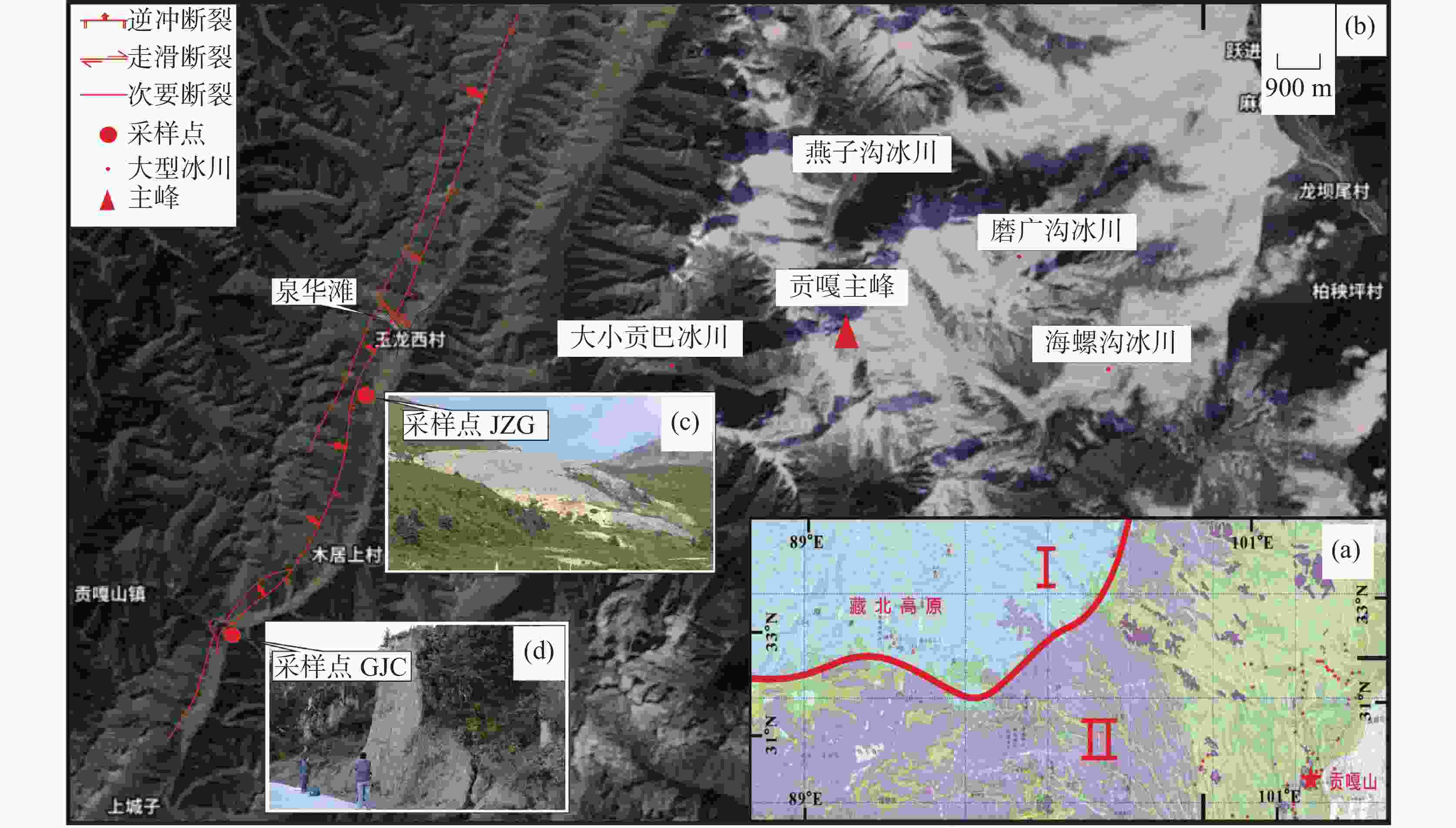
图 1 研究区位置及采样点分布图
a.Ⅰ:大陆性冰川区;Ⅱ:海洋性冰川区,底图为1∶5 000 000冰川、雪被、冻土和泥石流分布图 b.贡嘎山周边主要冰川及分布 c.采样点决支沟JZG d.采样点格晋查GJC
Figure 1. Distribution of sampling points and location of the study area
a.I: Continental Glacier Area; II: Marine Glacier Area (The base map in 1∶5,000,000 presents the distribution of glacier, snow cover, frozen soil, and debris flow b.Main glaciers and their distribution around Gongga mountain c.Sampling point Juezhigou JZG d.Sampling point Gejincha GJC)
图 4 研究区卫星图
(a.红点标识为钙华体出露位置,数字号码为钙华体编号;b.黄色框选区域的高光谱卫星影像,黄色虚线条为玉龙西断裂,红色斑块为ENVI方解石识别结果)
Figure 4. Satellite map of the study area
(a. red dot: the exposed locations of travertine, number: the number of travertine; b. Hyperspectral satellite images of the yellow boxed area; yellow dashed line: the Yulongxi fault; red patches: identification of ENVI calcite)
表 1 采样点野外信息记录
Table 1. Field information records of sampling points
样品编号 经度 纬度 海拔 /m 特征描述 JZG-01
JZG-02
JZG-03101°39′38.77″
101°39′36.37″
101°39′34.03″29°33′50.5″
29°33′51.47″
29°33′53.08″4029.0 4043.5 4055.7 疏松钙华风化物、钙华块与
灰黑色云母片岩混杂GJC-01
GJC-02
GJC-03101°36′9.01″
101°36′13.28″
101°36′14.28″29°27′12″
29°27′7.33″
29°27′8.26″3751.0 3754.6 3751.9 灰白色泥页岩与半固结黏土岩 表 2 高分五号高光谱相机主要技术指标
Table 2. Main technical indicators of hyperspectral camera onboard GF-5
光谱分辨率/nm 空间分辨率/m 幅宽/km 光谱范围/μm VNIR:5 30 60 0.4~2.5 SWIR:10 表 3 精灵4 RTK功能参数
Table 3. Function parameters of Phontom 4 RTK
最大起飞海拔 6 000 m飞行时间 约30 min 影像传感器 1 英寸 CMOS;
有效像素 2 000 万(总像素 2 048 万)镜头 FOV 84°;
8.8 mm / 24 mm(35 mm 格式等效);
光圈 f/2.8 - f/11;
带自动对焦(对焦距离 1 m - ∞)定位精度 垂直1.5 cm+1 ppm(RMS);
水平1 cm+1 ppm(RMS)照片最大分辨率 4864 ×3648 (4∶3);5472 ×3648 (3∶2)表 4 钙华体延伸方向与坡向夹角统计
Table 4. Statistics of the angles between extension direction and slope direction
钙华编号 夹角/° 坡向 坡度/% 海拔跨度/m 长/m 宽/m 长宽比 1 8 S 75 4 087 ~4 266 − − − 2 45 E 65 4 123 ~4 222 − − − 3 12 SW 56 4 130 ~4 175 79.6 21.2 3.75∶1 4 3 NE 57 4 282 ~4 313 54.0 11.4 4.74∶1 5 3 NE 54 4 275 ~4 301 47.8 13.3 3.59∶1 6 2 NE 55 4 254 ~4 277 42.0 9.2 4.57∶1 7 12 E 83 4 293 ~4 349 − − − 9 20 SE 21 4 292 ~4 302 48.3 8.1 5.96∶1 10 24 SE 25 4 283 ~4 290 28.0 4.5 6.22∶1 11 21 E 25 4 230 ~4 246 65.0 17.1 3.80∶1 12 10 SE 27 4 227 ~4 241 52.7 16.5 3.19∶1 17 13 SE 37 4 293 ~4 339 124.3 35.5 3.50∶1 18 24 SE 53 4 386 ~4 409 43.6 8.1 5.38∶1 19 7 SE 5 4 252 ~4 255 57.5 10.5 5.48∶1 20 4 SE 7 4 247 ~4 250 30.7 12.9 2.38∶1 24 18 E 33 4 245 ~4 260 45.2 24.0 1.88∶1 25 15 E 66 4 371 ~4 401 44.9 7.8 5.76∶1 26 5 E 18 4 335 ~4 356 115.1 24.4 4.72∶1 平均值 13.67 − 42.33 − 59.25 15.00 3.95∶1 表 5 X射线衍射分析结果
Table 5. Results of X-ray diffraction analysis
样品编号 GJC−01 GJC−02 GJC−03 JZG−01 JZG−02 JZG−03 石英/% 42.4 13.9 37.9 49.9 53.2 53.1 方解石/% − 63.4 − − − − 斜绿泥石/% 8.1 7.4 14.1 19.9 14.3 11.8 伊利石/% 15.0 11.9 26.3 − − − 钠长石/% 21.1 − 14.0 4.2 6.1 6.5 正长石/% − − − 0.4 1.3 1.2 钾长石/% 2.2 − 2.3 − − − 蒙脱石/% 5.3 1.3 1.5 1.2 3.4 1.5 堇青石/% 5.1 0.8 1.8 − − − 伊利—蒙脱石/% 0.8 − 2.1 − − − 白云母/% − 1.3 − 24.1 21.5 25.6 高岭石/% − − − 0.3 0.2 0.3 -
[1] 施雅风, 刘潮海, 王宗太, 刘时银, 叶柏生. 简明中国冰川目录[M]. 上海:上海科学普及出版社, 2005:1-194. [2] Kaplan M R, Licht K J, Lamp J L, Winckler G, Schaefer J M, Graly J A, Kassab C M, Schwartz R. Paleoglaciology of the central East Antarctic Ice Sheet as revealed by blue-ice sediment[J]. Quaternary Science Reviews, 2023, 302: 107718. [3] Ray Yogesh, Sen Subhajit, Sen Koushick, Beg M Javed. Quantifying the past glacial movements in Schirmacher Oasis, East Antarctica[J]. Polar Science, 2021, 30:100733. [4] Priestley S C, Karlstrom K E, Love A J, Crossey L J, Polyak V J, Asmerom Y, Meredith K T, Crow R, Keppel M N, Habermehl M A. Uranium series dating of Great Artesian Basin travertine deposits: Implications for palaeohydrogeology and palaeoclimate[J]. Palaeogeography, Palaeoclimatology, Palaeoecology, 2018, 490: 163-177. doi: 10.1016/j.palaeo.2017.10.024 [5] 刘再华. 表生和内生钙华的气候环境指代意义研究进展[J]. 科学通报, 2014, 59(23):2229-2239.LIU Zaihua. Research progress in paleoclimatic interpretations of tufa and travertine[J]. Chinese Science Bulletin, 2014, 59(23): 2229-2239. [6] Maarten Krabbendam, Neil F Glasser. Glacial erosion and bedrock properties in NW Scotland: Abrasion and plucking, hardness and joint spacing[J]. Geomorphology, 2011, 130(3-4): 374-383. [7] David J A Evans, Colm Ó Cofaigh. The sedimentology of the Late Pleistocene Bannow Till stratotype, County Wexford, Southeast Ireland[J]. Proceedings of the Geologists' Association, 2008, 119(3): 329-338. [8] 廖海军, 刘巧, 钟妍, 鲁旭阳. 1990—2019年贡嘎山地区典型冰川表碛覆盖变化及其空间差异[J]. 地理学报, 2021, 76(11):2647-2659. doi: 10.11821/dlxb202111004LIAO Haijun, LIU Qiao, ZHONG Yan, LU Xuyang. Supraglacial debris-cover change and its spatial heterogeneity in the Mount Gongga, 1990–2019[J]. Acta Geographica Sinica, 2021, 76(11): 2647-2659. doi: 10.11821/dlxb202111004 [9] Liu Qiao, Zhang Yong. Studies on the dynamics of monsoonal temperate glaciers in Mt. Gongga: A review[J]. Mountain Research, 2017, 35(5): 717-726. [10] 何元庆, 张忠林, 姚檀栋, 陈拓, 庞洪喜, 章典. 中国季风温冰川区近代气候变化与冰川动态[J]. 地理学报, 2003(4):550-558. doi: 10.3321/j.issn:0375-5444.2003.04.009HE Yuanqing, ZHANG Zhonglin, YAO Tandong, CHEN Tuo, PANG Hongxi, ZHANG Dian. Modern changes of the climate and glaciers in China's monsoonal temperate-glacier region[J]. Acta Geographica Sinica, 2003(4): 550-558. doi: 10.3321/j.issn:0375-5444.2003.04.009 [11] 苏珍, 梁大兰, 洪明. 贡嘎山海洋性冰川发育条件及分布特征[J]. 冰川冻土, 1993, 15(4):551-558.SU Zhen, LIANG Dalan, HONG Ming. Developing conditions, amounts and distributions of glaciers in Gongga mountains[J]. Journal of Glaciology and Geocryology, 1993, 15(4): 551-558. [12] 王富东, 赵学钦, 董发勤, Enrico Capezzuoli, Alexander I Malov, 杜杰. 青藏高原东缘九寨沟高寒钙华分类与命名[J]. 中国岩溶, 2021, 40(1):112-124.WANG Fudong, ZHAO Xueqin, DONG Faqin, Enrico Capezzuoli, Alexander I Malov, DU Jie. Classification of Alpine-type travertine in Jiuzhaigou valley on the eastern margin of the Qinghai-Tibet Plateau[J]. Carsologica Sinica, 2021, 40 (1): 112-124. [13] 陈安泽. 旅游地学大辞典[M]. 北京:科学出版社, 2013.CHEN Anze. Dictionary of tourism geotourism[M]. Beijing: Science Press, 2013. [14] 郭卫星. 川西北自然风景中钙华景观的形成与发育[J]. 山地研究, 1988, 6(1):54-60.GUO Weixing. The formation and development of travertine landscape in natural scenery of northwest Sichuan[J]. Mountain Research, 1988, 6(1): 54-60. [15] 周绪纶. 论岷山地区冰缘岩溶[J]. 四川地质学报, 2013, 33(4):479-487.ZHOU Xulun. On periglacial karst in the Minshan mountains[J]. Acta Geologica Sichuan, 2013, 33(4): 479-487 [16] 牛新生, 郑绵平, 刘喜方, 齐路晶. 青藏高原钙华沉积属性特征及其地质意义[J]. 科技导报, 2017, 35(6):59-64.NIU Xinsheng, ZHENG Mianping, LIU Xifang, QI Lujing. Sedimentary property and the geological significance of travertines in Qinghai-Tibetan Plateau[J]. Science & Technology Review, 2017, 35(6): 59-64. [17] 王杰, 雷满红, 郑利敏. 山地冰川冰消后(paraglacial)沉积的粒度与石英颗粒表面特征:以贡嘎山东坡为例[J]. 冰川冻土, 2022, 44(4):1150-1164.WANG Jie, LEI Manhong, ZHENG Limin. Grain size and quartz grain SEM microtextures of glacial tills and paraglacial deposits: A case study on the eastern slope of Mt.Gongga[J]. Journal of Glaciology and Geocryology, 2022, 44(4): 1150-1164. [18] 高帅坡. 川西北次级块体内部及其西边界断裂的晚第四纪活动习性[D]. 北京:中国地震局地质研究所, 2021.GAO Shuaipo. Late Quaternary paleoseismology and faulting behavior of the internal and western boundary faults of northwest Sichuan Subblock[D]. Beijing: Institute of Geology, China Earthquake Administration, 2021. [19] 白卉, 曲洪晔. 遥感DEM分析在新生代火山群提取和识别中的应用[J]. 吉林地质, 2017, 36(3):55-57. doi: 10.3969/j.issn.1001-2427.2017.03.012BAI Hui, QU Hongye. Application of remote sensing in the extraction and identification of Cenozoic volcano group based on DEM analysis[J]. Jilin Geology, 2017, 36(3): 55-57. doi: 10.3969/j.issn.1001-2427.2017.03.012 [20] 刘秦, 晏浩, 肖维阳, 肖瑶, 周率, 谢瑶, 乔雪, 唐亚. 九寨沟火花海堤坝修复后的水化学与钙华沉积研究[J]. 中国岩溶, 2023, 42(3):495-508. doi: 10.11932/karst20230302LIU Qin, YAN Hao, XIAO Weiyang, XIAO Yao, ZHOU Shuai, XIE Yao, QIAO Xue, TANG Ya. Water chemistry and tufa deposition on the restored dam of Huohua lake in the Jiuzhai valley[J]. Carsologica Sinica, 2023, 42(3): 495-508. doi: 10.11932/karst20230302 [21] 曹俊, 郭建强. 松潘黄龙自然保护区第四纪冰期划分与古气候环境分析研究[J]. 四川地质学报, 2001, 21(3):141-146. doi: 10.3969/j.issn.1006-0995.2001.03.004CAO Jun, GUO Jianqiang. Quaternary ice age division and paleoclimate and paleoenvironment in the Huanglong Nature Reserve, Songpan[J]. Acta Geologica Sichuan, 2001, 21(3): 141-146. doi: 10.3969/j.issn.1006-0995.2001.03.004 [22] 王富东, 赵学钦, 张海伟, 董发勤, 代群威, 孙仕勇, 李琼芳, 李刚. 黄龙地区古钙华铀系不平衡法测年[C]//中国矿物岩石地球化学学会. 中国矿物岩石地球化学学会第九次全国会员代表大会暨第16届学术年会文集, 2017. [23] 葛文彬, 范晓, 郭建强, 杨俊义, 曾令新, 吴昊, 彭东, 曹俊, 徐志文, 辜寄蓉. 九寨沟—黄龙核心景区地质环境与水循环系统研究[R]. 四川省地质矿产勘查开发局物探队, 2006. [24] 施雅风. 中国第四纪冰期划分改进建议[J]. 冰川冻土, 2002, 24(6):1-12.SHI Yafeng. A suggestion to improve the chronology of Quaternary glaciations in China[J]. Journal of Glaciology and Geocryology, 2002, 24 (6): 1-12. [25] 易朝路, 崔之久, 熊黑钢. 中国第四纪冰期数值年表初步划分[J]. 第四纪研究, 2005, 25(5):609-619.YI Chaolu, CUI Zhijiu, XIONG Heigang. Numerical periods of Quaternary glaciations in China[J]. Quaternary Sciences, 2005, 25(5): 609-619. [26] 郭建强, 曹俊. 四川康定县玉龙希钙华景观及其水循环系统[J]. 地球学报, 2009, 30(3):345-353. doi: 10.3321/j.issn:1006-3021.2009.03.008GUO Jianqiang, CAO Jun. Yulongxi travertine landscape in Kangding county of Sichuan Province and its related hydrological cycle system[J]. Acta Geoscientia Sinica, 2009, 30(3): 345-353. doi: 10.3321/j.issn:1006-3021.2009.03.008 [27] 施雅风, 姚檀栋. 中低纬度MIS 3b(54~44ka BP)冷期与冰川前进[J]. 冰川冻土, 2002, 24(1):1-9.SHI Yafeng, YAO Tandong. MIS 3b (54–44 ka BP) cold period and glacial advance in middle and low latitudes[J]. Journal of Glaciology and Geocryology, 2002, 24(1): 1-9. [28] 李吉均, 冯兆东, 周尚哲. 横断山第四纪冰川作用遗迹[A]//横断山冰川. 北京:科学出版社, 1996:157-173. [29] 马秋华. 贡嘎山西坡的第四纪冰川作用[J]. 冰川冻土, 1994, 16(1):60-65.MA Qiuhua. Quaternary glaciation on the west slope of Mt.Gongga[J]. Journal of Glaciology and Geocryology, 1994, 16(1): 60-65. [30] 于贝贝. 贡嘎山地区古冰川演化序列及其气候驱动机制研究[D]. 兰州: 兰州大学, 2018.YU Beibei. Timing and climate drivers of Quaternary glaciations in the Gongga Shan, eastern Tibetan Plateau[D]. Lanzhou: Lanzhou University, 2018. [31] Yao T D, Thompson L G, Shi Y F, Qin D H, Jiao K Q, Yang Z H, Tian L D, Thompson E M. Climate variation since the last interglaciation recorded in the Guliya ice core[J]. Science in China Series D: Earth Sciences, 1997, 40(6): 662-668. [32] 王杰. 青藏高原及周边地区MIS 3中期冰进探讨[J]. 第四纪研究, 2010, 30(5):1055-1065. doi: 10.3969/j.issn.1001-7410.2010.05.23WANG Jie. Glacial advance in the Qinghai-Tibet Plateau and peripheral mountains during the mid-MIS 3[J]. Quaternary Sciences, 2010, 30(5): 1055-1065. doi: 10.3969/j.issn.1001-7410.2010.05.23 -


 下载:
下载:


