

Features and genesis analysis of geological relics of karst landforms in the Laoshan area of Malipo, Yunnan Province
-
摘要: 麻栗坡老山地区位于滇东南岩溶高原向越北三角洲平原过渡的中间地带,峡谷型岩溶地貌发育典型,形成了丰富多样的岩溶地貌地质遗迹,在中国西南及东南亚岩溶地貌演化过程中具有典型性和代表性。文章梳理出该区域岩溶地貌地质遗迹分布和发育特征及其形成原因,并探讨了云南典型峡谷型岩溶地貌区的形成及演化机理。结果表明:(1)研究区形成了涵盖地表、地下及其过渡型岩溶地貌以及水体地貌等4种地质遗迹类型,以峰丛洼地(谷地)、峡谷、洞穴群、瀑布群和岩溶泉群及其景观组合为特色;(2)研究区溶洞可以划分出>
1 750 m、1 600 ~1 200 m、1 000~600 m、500~200 m、<150 m 共5个层级,溶洞类型为旱洞、出水洞、入水洞及其混合型溶洞;(3)地层、岩性—构造背景下的水文地质条件为塑造该区丰富的岩溶地貌地质遗迹类型提供了外部动力因素;(4)晚中生代以来研究区岩溶地貌地质遗迹成因演化过程可初步划分为燕山期构造盆地形成和喜马拉雅期地壳差异性抬升两个阶段。Abstract:The Laoshan area in Malipo, Yunnan Province is located in the transitional zone from the karst plateau in southeastern Yunnan to the Red River Delta Plain in Northern Vietnam, where the gorge-type karst landform is typically developed, forming a rich and diverse set of geological relics of karst landforms. These relics play an important connecting role and are typical representatives in the evolution process of karst landforms in Southwest China and Southeast Asia. Since 2013, the development of the scenic area named "Heroic Laoshan Sacred Land" has prominently featured nature sightseeing tours centered around geological relics of karst landforms. Surveys have found 47 typical geological relics in this area, characterized by cave groups, canyon groups, waterfall groups, peak-cluster depressions, and peak-cluster valleys. However, the existing data indicates that this area primarily focuses on the investigation and research of mineral resources, and structural and rock unit systems. In contrast, there is a significant gap in understanding the unique geological relic characteristics and composition of subtropical canyon-type karst landforms, as well as their spatial distribution, and evolutionary causes, which are critical issues. This lack of understanding has affected high-quality development and reasonable protection, and there is an urgent need for further research and discussion. Therefore, based on the investigation of karst landform geological relics, it is essential to enhance studies on the characteristics and genesis analysis of geological relics in the study area. These studies are of practical significance for revealing the formation and evolutionary mechanisms of the typical areas developed with karst landforms that transition from the karst plateau in southeastern Yunnan to the plains of the Northern Vietnamese Delta. Additionally, these studies will contribute to the economic development of border area tourism and the prosperity of the border area and its inhabitants. This article analyzes the distribution and developmental characteristics of geological relics of karst landforms in the study area, examines the causes of their formation, and, based on previous research findings, discusses the formation and evolutionary mechanisms of typical canyon karst landforms in Yunnan. The results show as follows, (1) The study area boasts a rich variety of geological relics of karst landform, including surface karst landforms, subsurfaces karst landforms, transitional karst landforms and hydrological landforms. Surface karst landforms include peak clusters, depressions, karst gorges, clints, grikes and karstic traces. Subsurface karst landforms consist of karst caves, underground rivers, and various depositional forms. The transitional karst landforms from surface to subsurface are represented by small-scale karst collapse doline groups that are locally exposed. Hydrological landforms include karst waterfalls and karst springs. (2) The study area is characterized by gorge-type karst landforms, with developed karst caves that exhibit stratification. The types of caves and depositional forms at different levels are similar, with low-altitude caves being a distinctive feature. They can be divided into five levels: > 1,750 m,1,200 –1,600 m, 600–1,000 m, 200–500 m, and <150 m. The main types of caves are dry caves, water-out caves, water-in caves, and their mixed types. In the karst dry caves, there is a significant amount of collapse debris of original rock or sandy silt blocking the cave passages, and secondary chemical sediments are generally underdeveloped. There are few large cave halls in the caves, and medium to large-scale caves represented by Qingliang cave and Mangun cave are characterized by different traces and different periods of structures overlapping and interacting with each other and by double-layered development. Several caves with convenient transportation show clear signs of human activities, but the most remain in their pristine states. (3) The Wenshan-Malipo NW-trending left-lateral strike-slip fault zone significantly influences the formation and evolution of geological relics of karst landforms. The geological relics of karst landforms are mainly distributed in a northwest to southeast strip along the karst gorge of the Nanwen river. The multi-stage uplift of neotectonic movements also has significantly impacted the formation of karst landforms. The continuous deposition, stable stratification, and extensive distribution of Cambrian, Devonian, and Permian carbonate formations, characterized by significant depositional thickness in the study area create optimal material conditions for the formation and development of geological relics. These factors also control the regional distribution of these relics. At the same time, the study area is located in the subtropical monsoon climate zone, south of the Tropic of Cancer, where the unique climate and hydrological conditions have a significant impact on the formation of karst landforms. The abundant atmospheric precipitation provides ample water sources for the karstification process in this area. (4) Based on previous research findings and comparison of regional elevations, landform morphologies, individual morphological characteristics of karst landforms in the study area, as well as the conditions for the formation of different landform combinations, the genesis and evolutionary process of geological relics of karst landforms in the study area since the Late Mesozoic can be preliminarily divided into two stages: the formation of the tectonic basin during the Yanshan Period and the crustal differential uplift during the Himalayan Period.-
Key words:
- karst landform /
- geological relics /
- genesis analysis /
- Malipo county /
- Yunnan Province
-
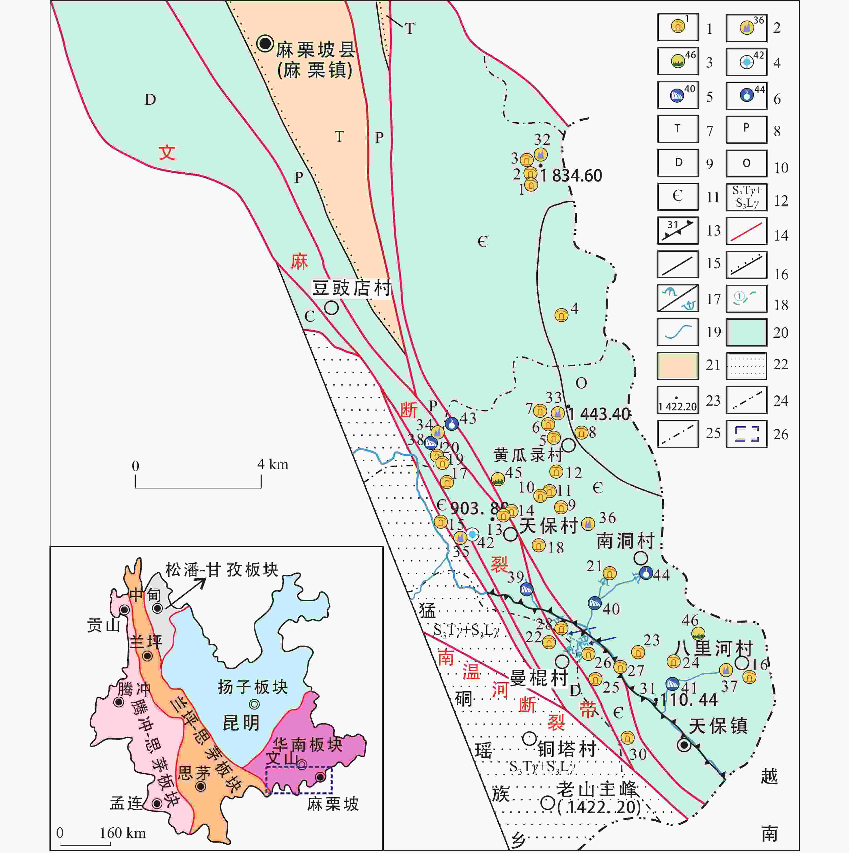
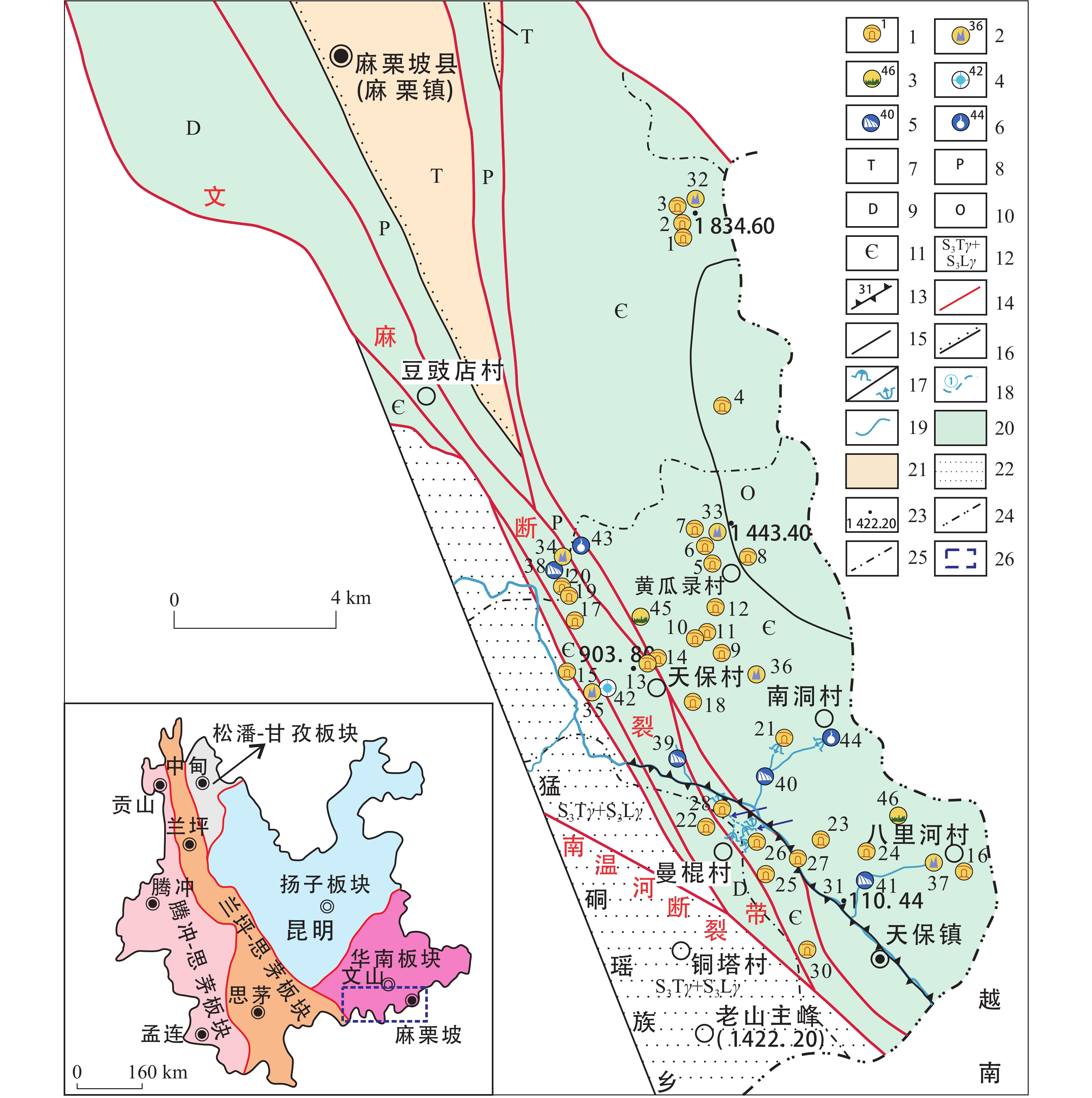
图 1 研究区区域地质(左)[10]与典型岩溶地貌地质遗迹分布图(右)[13]
1.溶洞及编号 2.峰丛及编号 3.石芽及编号 4.天窗及编号 5.瀑布及编号 6.岩溶泉及编号 7.三叠系 8.二叠系 9.泥盆系 10.奥陶系 11.寒武系 12.团田+老城坡岩体 13.峡谷及编号 14.断层 15.地层界线 16.地层不整合接触界线 17.地下河入口及出口 18.地下河及编号 19.地表河流 20.岩溶区 21.半岩溶区 22.非岩溶区 23.高程 24.乡镇界线 25.国界 26.研究区范围线
Figure 1. Regional geological map (left)[10] and distribution of typical geological relics of karst landforms in the study area (right)[13]
1. karst cave and numbering 2. peak cluster and numbering 3. clint and numbering 4. skylight and numbering 5. waterfall and numbering 6. karst spring and numbering 7. Triassic 8. Permian 9. Devonian 10. Ordovician 11. Cambrian 12. Tuantian and Laochengpo rock mass 13. canyon and numbering 14. fault 15. stratigraphic boundary 16. stratigraphic unconformity contact line 17. inlet and outlet of underground river 18. underground river and numbering 19. surface river 20. karst area 21. semi-karst area 22. non-karst area 23. elevation 24. township boundary 25. national boundary 26. range line of the study area
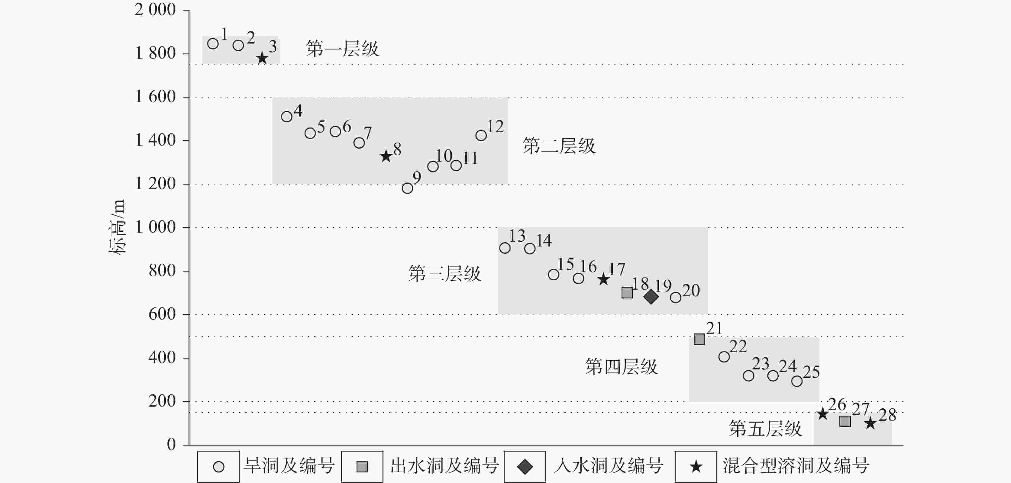
图 3 研究区南温河峡谷两侧溶洞分层特征示意图
Figure 3. Schematic diagram of stratification characteristics of karst caves along the two sides of the Nanwen river gorge in the study area
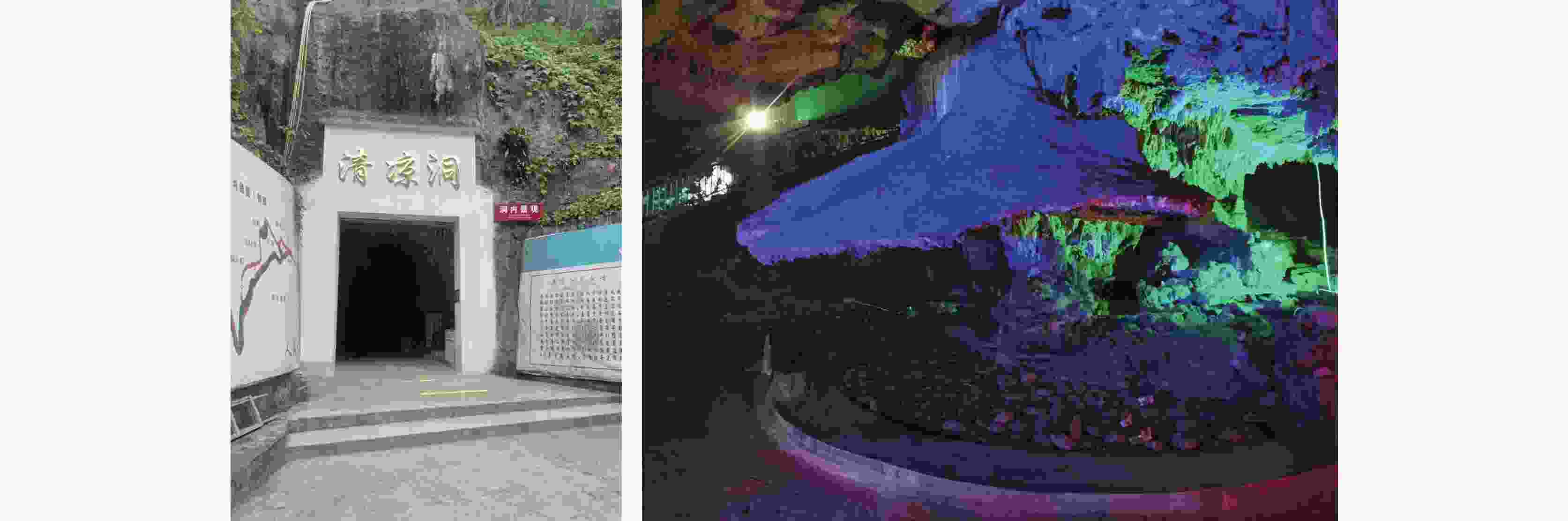
图 4 清凉洞洞口和洞顶胶结花岗岩鹅卵石形成的“大灵芝”景观
Figure 4. "Big Ganoderma" landscape formed by the cementation of granite pebbles at the mouth and the top of Qingliang cave
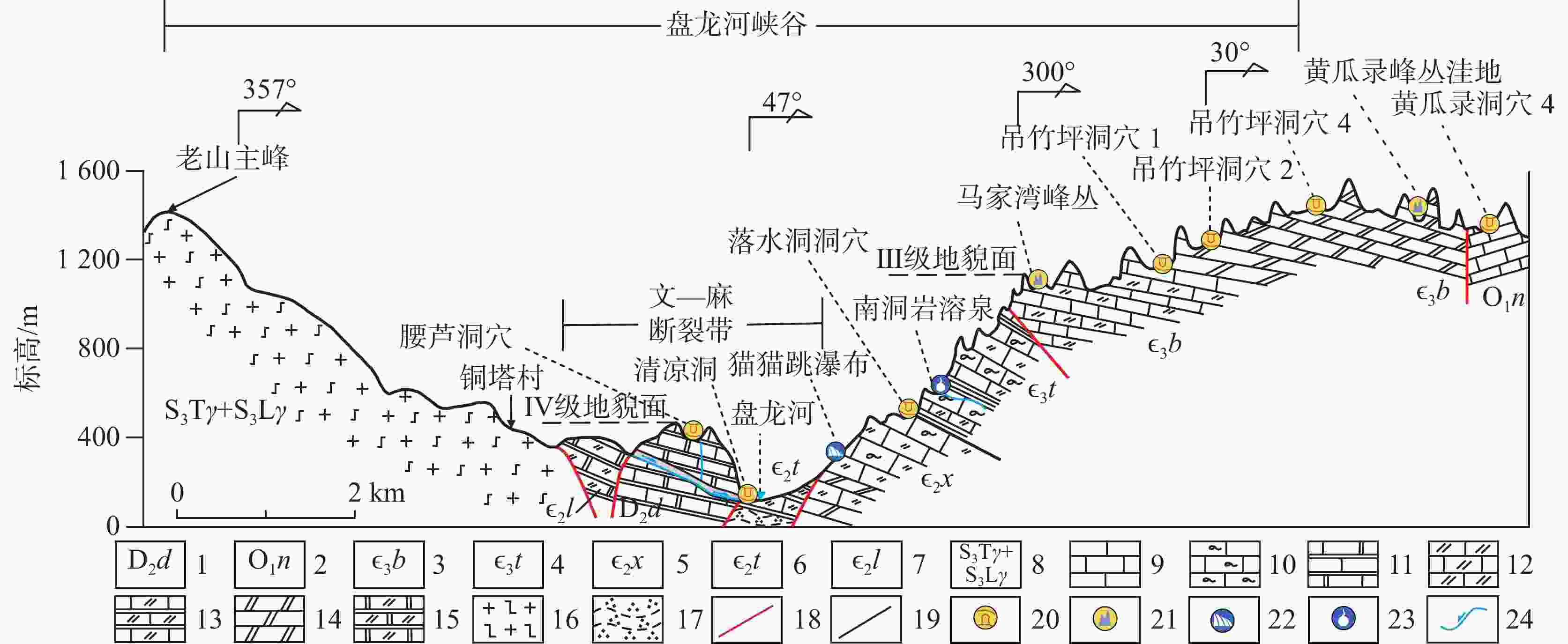
图 7 研究区综合地质地貌剖面示意图
1.中泥盆统东岗岭组 2.下奥陶统南津关组 3.上寒武统博莱田组 4.上寒武统唐家坝组 5.中寒武统歇场组 6.中寒武统田蓬组 7.中寒武统龙哈组 8.团田+老城坡岩体 9.灰岩 10.泥质条带灰岩 11.大理岩化灰岩 12.白云质灰岩 13.大理岩化白云质灰岩 14.白云岩 15.白云质大理岩 16.片麻状花岗岩 17.石英千枚岩 18.断层 19.地层界线 20.溶洞 21.峰丛(洼地) 22.岩溶瀑布 23.岩溶泉 24.地下河及流向
Figure 7. Schematic profile of comprehensive geology and geomorphy in the study area
1. Donggangling formation in middle Devonian 2. Nanjinguan formation in lower Ordovician 3. Bolaitian formation in upper Cambrian 4. Tangjiaba formation in upper Cambrian 5. Xiechang formation in middle Cambrian 6. Tianpeng formation in middle Cambrian 7. Longha formation in middle Cambrian 8. Tuantian and Laochengpo rock mass 9. limestone 10. muddy-banded limestone 11. marbled limestone 12. dolomitic limestone 13. marbled dolomitic limestone 14. dolomite 15. dolomitic marble 16. gneissose granite 17. quartz phyllite 18. fault 19. stratigraphic boundary 20. karst cave 21. peak cluster (depression) 22. karst waterfall 23. karst spring 24. underground river and its flow direction
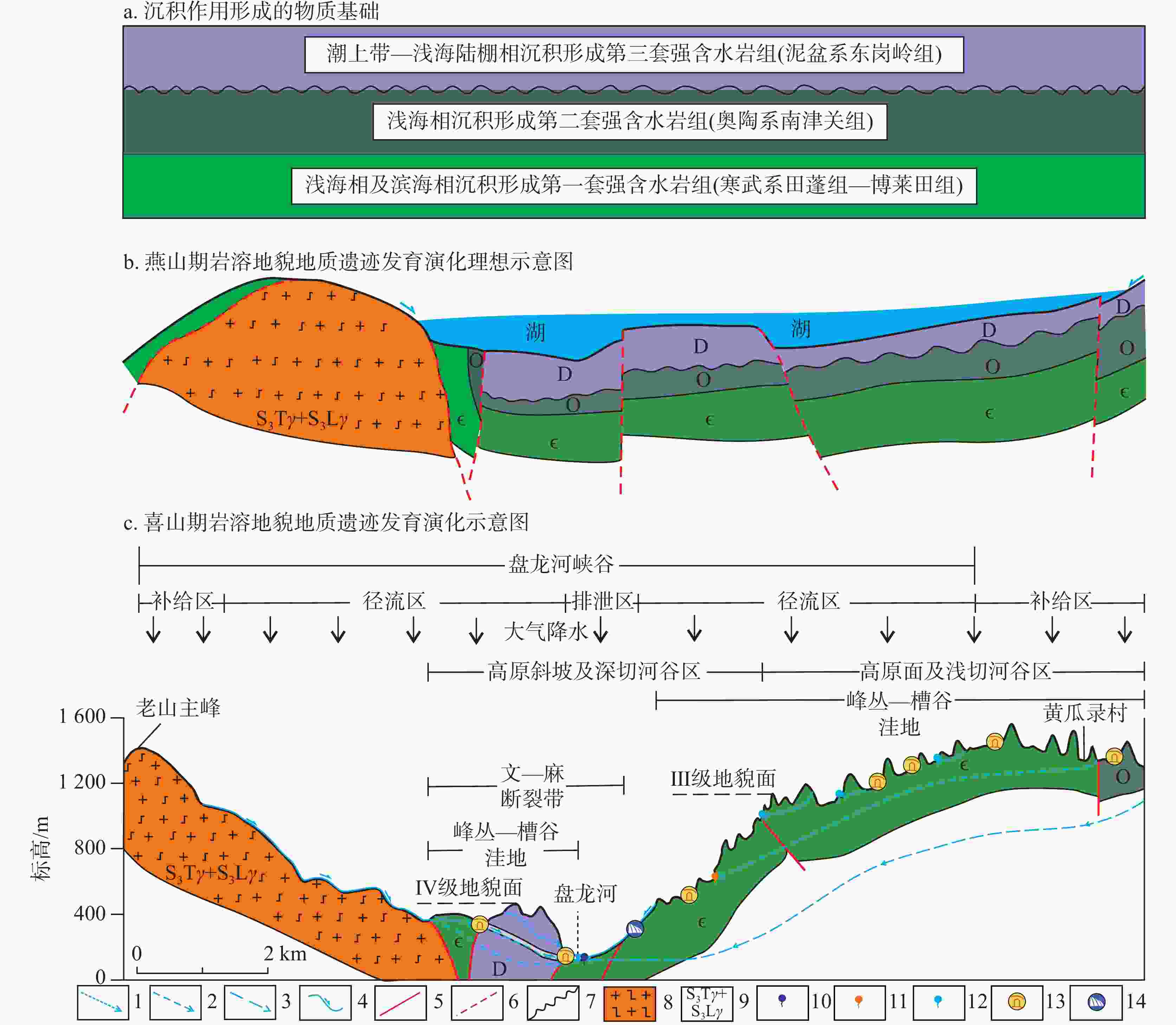
图 8 研究区地质遗迹成因演化示意图[28]
1.表层径流 2.浅循环径流 3.深循环径流 4.地表流水及方向 5.断层 6.推测断层 7.角度不整合界线 8.团田+老城坡岩体 9.片麻状花岗岩 10.深循环径流排泄点 11.浅循环径流排泄点 12.表层径流排泄点 13.洞穴 14.岩溶瀑布
Figure 8. Genesis evolution of geological relics in the study area
1. surface runoff 2. shallow circulation runoff 3. deep circulation runoff 4. surface flow and direction 5. fault 6. presumed fault 7. angular unconformity line 8. Tuantian and Laochengpo rock mass 9. gneissose granite 10. discharge point of deep circulation runoff 11. discharge point of shallow circulation runoff 12. discharge point of surface runoff 13. cave 14. karst waterfall
表 1 研究区典型岩溶地貌地质遗迹形态
Table 1. Forms of typical geological relics of karst landforms in the study area
区域 地表型岩溶地貌
溶蚀、侵蚀形态地下型岩溶地貌
溶蚀、侵蚀形态地下型岩溶地貌
沉积、溶蚀形态过渡型岩溶地貌
溶蚀、侵蚀形态宏观地貌 微观貌 宏观地貌 机械堆积物 次生化学沉积物 微地貌 宏观地貌 天保镇 峰丛洼地(33.黄瓜录、34.散水村、35.平安坡、36.马家湾、37.八里河东山)、石牙(45.苏麻湾、46.谷地坪)、峡谷(31.南温河) 溶纹、
溶痕、
溶窝、
溶斗、
溶沟、
溶槽溶洞群(1-3.下月亮坝、4.下围山、5-8.黄瓜录、9-12.吊竹坪、13-14.平安坡、15.新城、16.八里河、17.老寨、18.夭六、19-20.散水、21.落水洞、
22.腰芦、23.双河村、24.三转弯、25.干田、26.曼棍洞、27.那马、28.清凉洞)沙泥质崩塌堆积物、黏土堆积物、砾石胶结层 滴石类(石钟乳、石笋、石柱、鹅管、石旗、石盾),流石类(石幔、石瀑布)、池水类(石田、边池坝和莲花盆)、非重力水类(石花和石珍珠等) 波痕、
边槽、
流痕、
窝穴、
沟槽、
井管、
蚀龛、
堑沟、
天沟、
天锅漏斗
(42.平安坡
漏斗群)麻栗镇 峰丛谷地
(32.茨竹坝) 下载: 导出CSV
表 2 研究区不同海拔高程岩溶洞穴发育特征表
Table 2. Development characteristics of karst caves at different altitudes in the study area
序号 名 称 发 育 地 层 水文特征 洞口标高/m 洞口规模(宽×高)/m 长度/m 钟乳石 层级 1 下月亮坝洞穴1 博菜田组(∈3b) 旱洞 1842.90 1.6×2.4 廊道状 20 不发育 1 2 下月亮坝洞穴2 博菜田组(∈3b) 旱洞 1834.60 15.0×11.0 竖井状 >32 少量 1 3 下月亮坝洞穴3 博菜田组(∈3b) 混合型 1782.00 20.0×3.8 廊道状 >10 不明 1 4 下山围洞穴 南津关组(O1n) 旱洞 1512.20 1.9×2.1 廊道状 19 不发育 2 5 黄瓜录洞穴1 博菜田组(∈3b) 旱洞 1433.50 11.0×4.3 厅堂状 15 少量 2 6 黄瓜录洞穴2 博菜田组(∈3b) 旱洞 1443.40 1.8×2.0 廊道/厅堂复合状 62 少量 2 7 黄瓜录洞穴3 博菜田组(∈3b) 旱洞 1394.00 9.0×5.8 厅堂状 16 少量 2 8 黄瓜录洞穴4 南津关组(O1n) 混合型 1325.30 12.0×4.5 廊道/厅堂复合状 >1 000 较发育 2 9 吊竹坪洞穴1 博菜田组(∈3b) 旱洞 1178.50 1.2×4.2 裂隙状 8 发育 2 10 吊竹坪洞穴2 博菜田组(∈3b) 旱洞 1283.40 8.0×10.0 廊道状 25 少量 2 11 吊竹坪洞穴3 博菜田组(∈3b) 旱洞 1284.30 6.5×7.3 厅堂状 60 少量 2 12 吊竹坪洞穴4 博菜田组(∈3b) 旱洞 1428.00 1.8×1.7 厅堂状 5 少量 2 13 平安坡洞穴1 歇场组(∈3x) 旱洞 903.90 4.6×5.8 厅堂状 7 不发育 3 14 平安坡洞穴2 唐家坝组(∈3t) 旱洞 903.70 3.5×3.5 厅堂状 4 不发育 3 15 新城洞穴 歇场组(∈3x) 旱洞 782.70 9.3×2.9 廊道状 5 少量 3 16 八里河洞 博菜田组(∈3b) 旱洞 767.00 0.7×1.4 裂隙状 20 不发育 3 17 老寨洞穴 东岗岭组(D2d) 混合型 760.90 4.2×2.5 厅堂状 42 较发育 3 18 夭六水洞 博菜田组(∈3b) 出水洞 700.00 2.9×2.7 廊道/厅堂复合状 23 少量 3 19 散水洞穴1 东岗岭组(D2d) 入水洞 685.90 1.5×2.1 竖井状 3 少量 3 20 散水洞穴2 东岗岭组(D2d) 旱洞 681.90 12.0×1.9厅堂状 不明 未知 3 21 落水洞洞穴 博菜田组(∈3b) 出水洞 491.10 5.3×4.8 裂隙状 >8 少量 4 22 腰芦洞穴 东岗岭组(D2d) 旱洞 401.60 18.0×3.9厅堂状 50 少量 4 23 双河村洞穴 博菜田组(∈3b) 旱洞 324.20 5.6×2.4 斜井状 24 发育 4 24 三转弯洞 歇场组(∈3x) 旱洞 324.20 2.3×1.3 廊道状 12 不发育 4 25 干田洞穴 吴家坪组(P3w) 旱洞 291.50 5.0×2.7 裂隙状 9 少量 4 26 曼棍洞 田蓬组(∈2t)
东岗岭组(D2d)混合型 146.50 52.0×23.0廊道/厅堂复合状 193 发育 5 27 那马水洞 歇场组(∈3x) 出水洞 110.44 1.5×1.5 廊道状 16 少量 5 28 清凉洞 田蓬组(∈2t)
东岗岭组(D2d)混合型 107.70 6.7×10.3廊道/厅堂复合状 >1 800 发育 5
下载: 导出CSV
表 3 研究区典型水体地貌地质遗迹主要特征表
Table 3. Main characteristics of typical aquatic geomorphic geological relics in the study area
序号 名 称 地理位置 地质遗迹编号 水文特征 主要景观特征 1 散水瀑布 天保镇散水村 38 常年性 由3级瀑布组成,总落差为166 m,瀑面宽2~9 m,总体朝向为270°,2021年4月19日流量约0.15 m3∙s−1;上级瀑布落差约为46 m,宽4~9 m,瀑面倾角80°,中级瀑布落差约40 m,瀑面宽2~4 m,瀑面倾角50°,下级瀑布瀑面宽2~4 m,高度大于4 m,瀑面倾角60° 2 新寨瀑布 天保镇天保村 39 季节性 由2级瀑布组成,总落差17 m,瀑面宽3~5 m,总体朝向为37°,2021年4月14日流量0.015 m3∙s−1;上下两级落差分别为11 m和6 m,两级瀑布顶底平距约10 m,瀑面倾角为68°和60° 3 猫猫跳瀑布 天保镇天保村 40 季节性 瀑布总体落差约195 m,瀑面宽5~15 m,总体朝向为75°,平面流程约470 m,为瀑面倾角在60°~85°之间的多级季节性跌水瀑布,其间有数级高5~18 m不等的单级瀑布,2021年4月8日大雨后瀑布总流量约2 m3∙s−1 4 偏马瀑布 天保镇八里河村 41 季节性 单级瀑布,总落差为70 m,瀑面宽0.5~1.2 m,瀑面倾角85°,总体朝向为250°,2021年3月29日流量0.01 m3∙s−1 5 大岩迁岩溶泉 天保镇天保村 43 长流泉 下降泉,泉口不规则状,泉眼宽约0.3 m,2021年4月24日流量约0.003 m3∙s−1,水质清澈,无冒泡现象 6 南洞岩溶泉 天保镇天保村 44 长流泉 下降泉,泉口不规则状,泉眼宽约0.6 m,2021年4月1日流量约0.005 m3∙s−1,水质清澈,无冒泡现象
下载: 导出CSV
-
[1] DZ/T 0303-2017. 地质遗迹调查规范[S]. 北京:中国标准出版社, 2017.DZ/T 0303-2017. Specification for geoheritage investigation[S]. Beijing: Standards Press of China, 2017. [2] 罗书文, 杨桃, 邓亚东, 覃星铭. 毕节鸡鸣三省·贵州地质公园地质遗迹特征及价值研究[J]. 中国岩溶, 2019, 38(6):946-956.LUO Shuwen, YANG Tao, DENG Yadong, QIN Xingming. Characteristics and value of geological relics in the Bijie Jiming Sansheng·Guizhou geopark[J]. Carsologica Sinica, 2019, 38(6): 946-956. [3] 邓亚东, 孟庆鑫, 吕勇, 罗书文, 潘明. 桂林地质遗迹景观特征及其保护开发策略研究[J]. 中国岩溶, 2021, 40(5):783-792.DENG Yadong, MENG Qingxin, LV Yong, LUO Shuwen, PAN Ming. Characteristics of geological heritage landscapes in Guilin and their protection and development strategies[J]. Carsologica Sinica, 2021, 40(5): 783-792. [4] 袁道先. 现代岩溶学在中国的发展[J]. 地质论评, 2006, 52(6):15-18.YUAN Daoxian. The development of modern karstology in China[J]. Geological Review, 2006, 52(6): 15-18. [5] 朱学稳. 我国峰林喀斯特的若干问题讨论[J]. 中国岩溶, 2009, 28(2):155-168.ZHU Xuewen. Discussions on Fenglin karst in China[J]. Carsologica Sinica, 2009, 28(2): 155-168. [6] 韦跃龙, 李成展, 陈伟海, 罗劬侃, 朱德浩, 潘天望. 广西岩溶景观特征及其形成演化分析[J]. 广西科学, 2018, 25(5):465-504.WEI Yuelong, LI Chengzhan, CHEN Weihai, LUO Qukan, ZHU Dehao, PAN Tianwang. Characteristics and formation and evolution analysis of the karst landscape of Guangxi[J]. Guangxi Sciences, 2018, 25(5): 465-504. [7] 中国地质科学院岩溶地质研究所. 西南岩溶区重点调查区碳酸盐岩地质遗迹详细调查与评价报告[R]. 2023. [8] Liu Y P, Ye L, Li C Y, Hu R Z. Laojunshan-Song Chay metamorphic core complex and its tectonic significance[C]//13th Annual VM Goldschmidt Conference, 2003.Liu Y P, Ye L, Li C Y, Hu R Z. Laojunshan-Song Chay metamorphic core complex and its tectonic significance[C]//13th Annual VM Goldschmidt Conference, 2003. [9] 阙朝阳. 云南麻栗坡南温河—洒西一带钨成矿系统及找矿方向研究[D]. 中国地质大学(北京), 2016.QUE Chaoyang. Tungsten metallogenic system and prospecting direction in the Nanwenhe−Saxi area, Malipo county, Yunnan Province[D]. Beijing: China University of Geosciences (Beijing), 2016. [10] 刘艳宾. 滇东南老君山地区燕山期花岗岩成因机制及钨锡成矿规律[D]. 北京:中国地质大学(北京), 2017.LIU Yanbin. Petrogenesis of the Yanshanian granite and metallogenic characteristics of the W-Sn polymetallic deposits in the Laojunshan region, southeastern Yunnan Province[D]. Beijing: China University of Geosciences, 2017. [11] 印贤波, 王杰亭, 刘争. 滇东南南部老君山地区成矿地质特征[J]. 西部资源, 2018(3):21-23. [12] 董树文, 李廷栋, 钟大赉, 王成善, 沙金庚, 陈宣华. 侏罗纪/白垩纪之交东亚板块汇聚的研究进展和展望[J]. 中国科学基金, 2009, 23(5):281-286.DONG Shuwen, LI Tingdong, ZHONG Dalai, WANG Chengshan, SHA Jingeng, CHEN Xuanhua. Recent progress and perspective of the research on J-K East Asian multi-direction convergent tectonics[J]. Bulletin of National Natural Science Foundation of China, 2009, 23(5): 281-286. [13] 云南省地质矿产局. 云南省区域地质志[M]. 北京:地质出版社, 1990.Yunnan Bureau of Geology and Mineral Resources. Journal of the Regional Geology of Yunnan Province[M]. Beijing: Geology Press, 1990. [14] 韦跃龙, 陈伟海, 罗劬侃, 罗书文. 贵州织金洞世界地质公园喀斯特成景机制及模式研究[J]. 地质论评, 2018, 64(2):457-476.WEI Yuelong, CHEN Weihai, LUO Qukan, LUO Shuwen. Study on the karst landscape formation mechanism and model of the Zhijindong Cave Global Geopark, Guizhou Province[J]. Geological Review, 2018, 64(2): 457-476. [15] 袁道先, 蒋勇军, 沈立成. 现代岩溶学[M]. 北京:科学出版社, 2016.YUAN Daoxian, JIANG Yongjun, SHEN Licheng. Modern Karstology[M]. Beijing: Science Press, 2016. [16] 朱学稳, 朱德浩, 黄保健, 陈伟海, 张远海, 韩道山. 喀斯特天坑略论[J]. 中国岩溶, 2003, 22(1):51-65.ZHU Xuewen, ZHU Dehao, HUANG Baojian, CHEN Weihai, ZHANG Yuanhai, HAN Daoshan. A brift study on karst Tiankeng[J]. Carsologica Sinica, 2003, 22(1): 51-65. [17] 夏凯生, 袁道先, 谢世友, 楚玉春. 乌江下游岩溶地貌形态特征初探:以重庆武隆及其邻近地区为例[J]. 中国岩溶, 2010, 29(2):196-204.XIA Kaisheng, YUAN Daoxian, XIE Shiyou, CHU Yuchun. Preliminary study on morphology features of karst in the lower reaches of Wujiang river: A case in Wulong, Chongqing and the surrounding area[J]. Carsologica Sinica, 2010, 29(2): 196-204. [18] 任娟刚, 洪增林, 张静, 唐力, 刘晓峰, 秦臻, 王鹏, 王研. 陕西宁强禅家岩天坑群喀斯特地质遗迹特征及成因[J]. 中国岩溶, 2021, 40(3):539-547.REN Juangang, HONG Zenglin, ZHANG Jing, TANG Li, LIU Xiaofeng, QIN Zhen, WANG Peng, WANG Yan. Features of geological relics and genesis of the Chanjiayan Tiankeng group in Ningqiang, Shaanxi Province[J]. Carsologica Sinica, 2021, 40(3): 539-547. [19] 邓自强, 林玉石, 张美良, 刘功余, 魏志民. 桂林岩溶洼地和洞穴发生、发展的构造控制剖析[J]. 中国岩溶, 1987, 6(2):48-59.DENG Ziqiang, LIN Yushi, ZHANG Meiliang, LIU Gongyu, WEI Zhimin. Analysis of controlling effects of structure on depressions and caves in Guilin[J]. Carsologica Sinica, 1987, 6(2): 48-59. [20] 田宜敏. 云南文山盆地渐新世早期地层年代学与古环境重建[D]. 昆明:昆明理工大学, 2021.TIAN Yimin. Chronostratigraphy and paleoenvironmental reconstruction during Early Oligocene of Wenshan Basin, Yunnan[D]. Kunming: Kunming University of Science and Technology, 2021. [21] 刘金荣. 广西热带岩溶地貌发育历史及序次探讨[J]. 中国岩溶, 1997, 16(4):332-345.LIU Jinrong. The development history of the Guangxi tropical karst geomorphology and its sequences[J]. Carsologica Sinica, 1997, 16(4): 332-345. [22] 陈宏峰, 张发旺, 何愿, 夏日元, 邹胜章, 苏春田, 罗书文. 地质与地貌条件对岩溶系统的控制与指示[J]. 水文地质工程地质, 2016, 43(5):42-47.CHEN Hongfeng, ZHANG Fawang, HE Yuan, XIA Riyuan, ZOU Shengzhang, SU Chuntian, LUO Shuwen. Geological and geomorphologic settings acting as the controlling factors and indicators for karst systems[J]. Hydrogeology & Engineering Geology, 2016, 43(5): 42-47. [23] 陈思宇. 云南高原岩溶洞穴的发育特征及地学意义[D]. 昆明:云南师范大学, 2018.CHEN Siyu. Developmental characteristics and significance in geoscience of karst caves in Yunnan Plateau[D]. Kunming: Yunnan Normal University, 2018. [24] 何发荣, 杨荆舟. 云南地质构造基本特征:兼论高原地壳演化形成机制[J]. 云南地质, 1982, 1(1):5-16. [25] 云南省地质矿产局. 马关幅F-48-91/20万区域水文地质普查报告[R]. 1980. [26] 明庆忠, 潘玉君. 对云南高原环境演化研究的重要性及环境演变的初步认知[J]. 地质力学学报, 2002, 8(4):361-368.MING Qingzhong, PAN Yujun. The elementary acknowledge on the importance of environmental evolution of Yunnan Plateau[J]. Journal of Geomechanics, 2002, 8(4): 361-368. [27] 王宇. 岩溶高原地下水径流系统垂向分带[J]. 中国岩溶, 2018, 37(1):1-8. doi: 10.11932/karst20180101WANG Yu. Vertical zoning of groundwater runoff system in karst plateau[J]. Carsologica Sinica, 2018, 37(1): 1-8. doi: 10.11932/karst20180101 [28] 魏泽跌, 李向东. 云南省昭通市昭阳区地质遗迹分布特征及成因分析[J]. 中国岩溶, 2024, 43(1):188-200.WEI Zeyi, LI Xiangdong. Distribution characteristics and genesis analysis of geological relics in Zhaoyang district, Zhaotong City, Yunnan Province[J]. Carsologica Sinica, 2024, 43(1): 188-200. -


 点击查看大图
计量
- 文章访问数: 587
- HTML浏览量: 187
- PDF下载量: 56
- 被引次数: 0
