

Measures for the protection and utilization of geo-environment during the urbanization in Yunnan
-
摘要: 云南省大地构造处于欧亚、印度洋、太平洋三大板块的汇聚地带。区内多次强烈的构造运动和频繁的岩浆活动形成了高原湖泊、三江峡谷、喀斯特地貌、高温热泉及火山遗迹等地貌景观,地质环境条件总体复杂且脆弱。改革开放40多年来,云南省经济快速增长,城镇化发展迅速。然而,也面临着地下水位下降、泉水干涸、雪线上升、地质灾害频发、石漠化等地质环境问题的困扰。如何在城镇化发展中避免或减轻地质环境问题的发生,保护地质环境就显得极为重要。通过综合分析,以六大水系流域为一级防护单元、高原湖泊流域为二级防护单元、重点地质遗迹为三级防护单元,分级分区划分保护区,明确保护目标与级别。研究城镇化与地质环境协调发展模式,重点关注环境脆弱敏感区域保护,开展城镇区地质环境综合动态监测,加强地质环境立体综合防护治理与非工程措施防护。实现城镇化与地质环境间的可持续发展,为解决城镇化发展进程中的地质环境问题提供对策。Abstract:
Yunnan, a province with a vast territory, is located in the southwest of China. It serves as a convergence zone for the Eurasian Plate, India Ocean Plate, and Pacific Plate. The western part of Yunnan belongs to Tethys–Himalaya orogenic belt, which exhibits strong crustal activities, while its eastern part falls into the stable or semi-stable platform and portions of the Pacific Plate. Yunnan subordinates both the Qinghai–Xizang Plateau and the Yunnan–Guizhou Plateau in terms of geomorphology. It is one of the youngest, most active and continuously rising plateaus, and also an area characterized by rare grand canyons. In this area, strong tectonic movements and frequent magmatic activities have formed many geomorphologic landscapes such as plateau lakes, stone forest landforms, volcano vestiges, Sanjiang gorge in the northwest of Yunnan, and hot springs in Tengchong. However, the geological conditions in Yunnan are generally complex and highly fragile. Since China's reform and opening-up over the past 40 years, Yunnan's economy has achieved great progress, and its urbanization has developed rapidly. However, while enjoying various convenience brought about by economy development, people from different ethnic groups in Yunnan are also facing a range of geo-environmental issues. These include declining water levels, drying water sources, rising snow lines, and other geological disasters. Therefore, finding ways to reduce or prevent the occurrence of geo-environment problems and to protect geo-environment during urbanization has become an important issue. This study uses a comprehensive research and analysis methodology. The entire area is categorized into six major water system basins, serving as the first-level protection unit, plateau-lake basins as the second-level protection unit, and key geological relics as the third-level protection unit. Additionally, the area can be divided into development, protection, and utilization zones, each with clearly defined protection goals and levels corresponding to each unit within the zone. In this study, we have put forward measures for the protection and utilization of geo-environment during the urbanization in Yunnan. We will strengthen research on the coordinated development model of urbanization and geological environment, and focus on areas with fragile geological environment. The key areas of geological environment vulnerability and sensitivity in Yunnan Province are divided into three major regions: the geological environment vulnerability zone on the southeastern edge of the Qinghai–Xizang Plateau in northwest Yunnan, the geological environment vulnerability zone in the dry-hot valley of the Jinsha river in northeast Yunnan, and the geological environment vulnerability zone between Ailao mountain and Wuliang mountain in southern Yunnan. In order to protect and utilize geo-environment, it is essential to enhance comprehensive dynamic monitoring of the geo-environment in urban areas within the area. This includes setting reference values for dynamic monitoring indicators and accurately capturing the changes in geo-environmental elements over time. We should promptly initiate the comprehensive protection and management of the geo-environment. Through human intervention, we can select appropriate engineering and non-engineering measures to restore the capacity and ensure the sustainable utilization of the geo-environment. The development of urban areas should be grounded in the characteristics of the geo-environment and aligned with the advantages of geographical resources. Additionally, effective national spatial planning should be implemented. Most towns can be typically constructed in basins and river valleys, where the terrain is more expansive, while a smaller number can be constructed on slopes of mountainous areas. This mountainous terrain will create a magnificent landscape that harmonious blends nature and culture. According to the terrain and landform conditions, cities and towns can be categorized into four types: mountain basin, mountain slope, valley basin, and valley slope. This classification aims to facilitate the development of aesthetically pleasing urban areas. In the future, research will focus on geo-environmental issues, including key points, hotspots, and challenges. The scientific understanding of how human activities impact the geo-environment, the implementation of coordinated development between urbanization and the geo-environment, and the enhancement of comprehensive three-dimensional protection and governance of the geo-environment are crucial for the advancement of urbanization and the effective protection of geo-environment. The mechanism behind the formation of geo-environmental problems should be studied in order to prevent geo-environment from exacerbation or occurrence. Studies should be conducted to promote sustainable development that balances urbanization with the geo-environment and to propose effective countermeasures for addressing geo-environmental problems. -
Key words:
- urbanization /
- geo-environment /
- dynamic monitoring /
- measure /
- protection and utilization /
- Yunnan
-
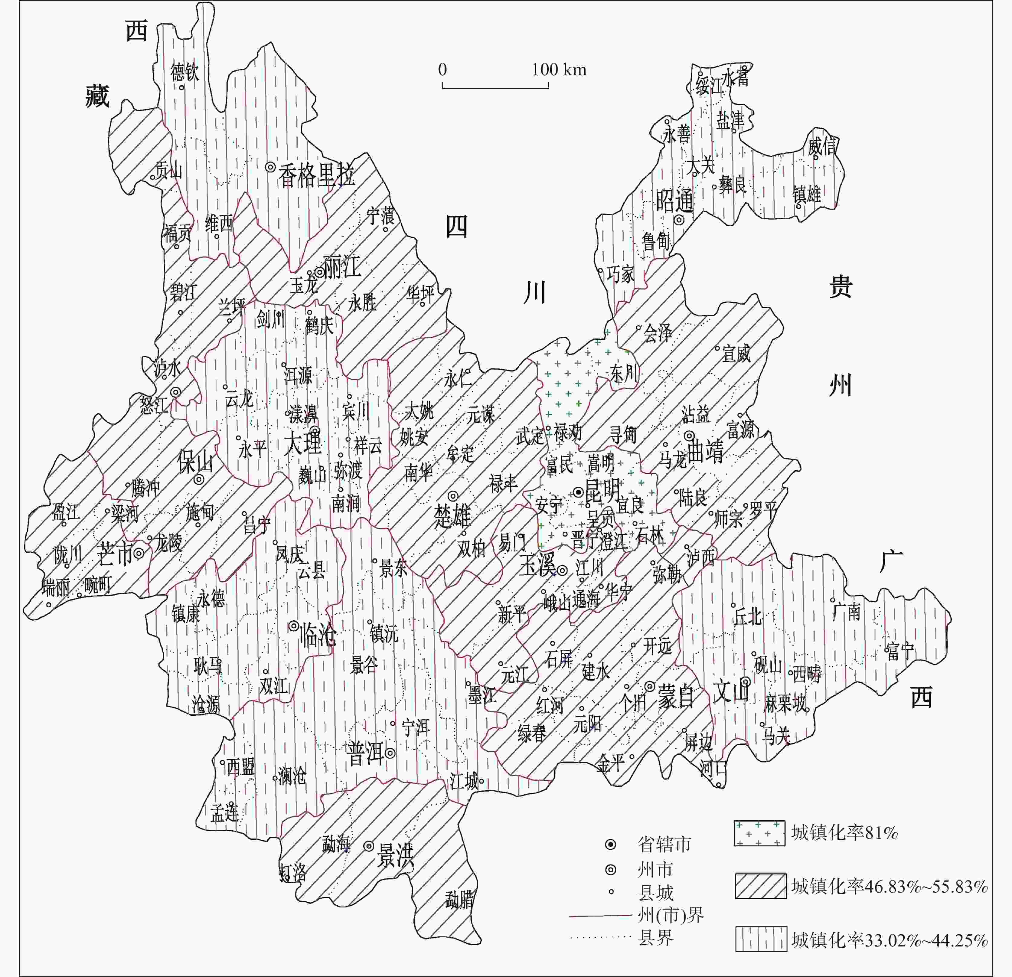
图 1 云南省各州(市)城镇化率分布图
Figure 1. Urbanization levels of autonomous prefectures/cities in Yunnan Province
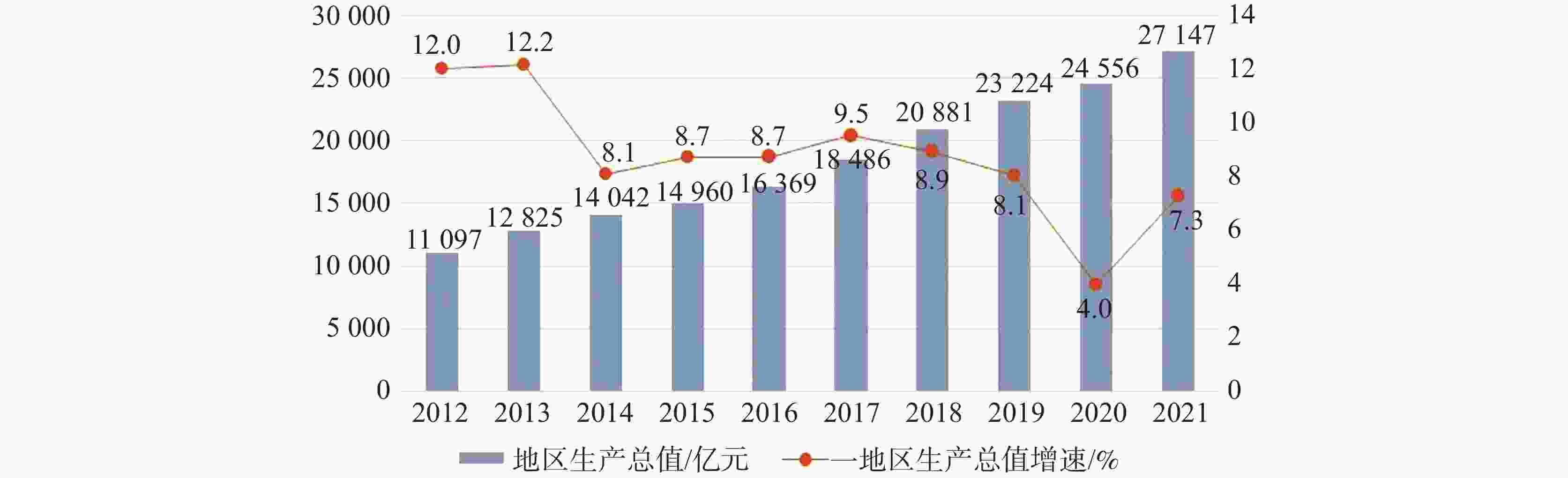
图 2 云南省2012-2021年地区生产总值及增速(引自“云南省统计局发布的十八大以来云南产业结构发展报告”)
Figure 2. GDP and its growth rate of Yunnan Province from 2012 to 2021 (Quoted from "Report on the Development of Yunnan's Industrial Structure Since the 18th National Congress Released by Yunnan Provincial Bureau of Statistics")
表 1 云南高山峡谷区部分大型-特大型地质灾害情况表
Table 1. List of geological hazards at a large scale and at an extraordinary large scale in the alpine gorge areas of Yunnan
发生位置 时间
年/月/日灾害类型 灾害等级 危害与损失 昆明禄劝普福滑坡 1965/11/22
—11/24滑坡 特大型 发生2次滑坡,滑体方量达4.5亿m3,滑坡掩埋了老深多、白占斗、电塘、阿角米、坝塘等5个村庄,444人遇难,223户 1 004 人被迫搬迁昭通头寨滑坡 1991/9/23 滑坡 特大型 滑坡方量达1 800万m3,造成216人死亡,并掩埋了村寨、农田、公路 德钦县城 2002/8 滑坡、泥石流 特大型 老街两侧和县政府背后斜坡地带的地表到处开裂变形,县医院锅炉房、洗澡间后墙被夷为平地,部分农户房屋被埋,出入城的交通线全部中断,多家单位无法正常上班;此次灾害损失严重,并引起居民恐慌和不安 盐津县庙坝乡民政存匹匠沟 2002/8/12 滑坡 特大型 7户人家受灾,13间房屋被毁,掩埋33人,救出4人(2人重伤) 小湾电站大沙坝沟 2002/8/17 泥石流 大型 造成5人死亡、2人失踪,18人受伤,冲毁工棚69间,施工设备一批 镇雄县五德镇大水
沟村2003/4/10 滑坡 大型 造成8人死亡,3辆拖拉机被埋,昭通至镇雄的主干公路损害100余米,直接经济损失近70万元 兰坪县河西乡三界布骡子沟 2003/5/13 滑坡 大型 由不合理采石诱发,造成3人死亡,采矿设备被毁 怒江州福贡县6乡1镇、58个行政村 2004/4/12
—4/20崩塌、滑坡、
泥石流特大型 长时间的降雨导致崩塌、滑坡、泥石流链式灾害大量发生,成灾的地质灾害点240多处,因地质灾害造成死亡2人、失踪4人、受伤7人,直接经济损失8 146.38万元 怒江州贡山、泸水、福贡、兰坪4县 2004/7/18
—7/24滑坡、泥石流 特大型 受暴雨天气影响,发生多起滑坡、泥石流灾害,造成农田、水利、交通、电力、民房等严重受损,因灾死亡9人,失踪7人,直接经济损失6 000万元 贡山县、德钦、维西县 2005/2/12
—2/17滑坡、泥石流 特大型 连续降雨、降雪,导致3县发生群发式崩塌、滑坡、泥石流灾害,造成交通多处中断,直接经济损失达2 033.64万元 怒江州贡山、福贡、兰坪3县 2005/3/1
—3/3崩塌、滑坡、
泥石流特大型 发生崩塌、滑坡、泥石流100余处,灾害导致18人死亡、1人失踪、1人重伤,直接经济损失约1.7亿元 大关县黄葛乡塘房村大桥社 2005/5/4 山洪、滑坡、
泥石流大型 因预报及时,危险区内38户全部撤到安全地带;泥石流堆积物20 000多方,冲击房屋24间,直接经济损失108.9万元,灾害未造成人员伤亡 贡山茨开镇嘎拉博村委会 2006/8/16 泥石流 大型 泥石流造成5人死亡、6人受伤,掩埋农田,公路和供水、供电、通讯线路全部中断,直接经济损失1 000余万元 盐津县 2006/8/25 滑坡、泥石流 大型 因地震诱发的次生地质灾害导致2人死亡 昭通市镇雄县泼机镇大院子村 2007/5/19 崩塌 大型 紧急疏散群众947人,崩塌持续4小时,导致房屋、农田被毁,直接经济损失1 755万元 怒江州泸水县六库镇石缸河、三岔河 2007/8/7 滑坡、泥石流 大型 暴雨诱发泥石流,造成8人死亡、7人受伤,直接经济损失30余万元 丽江市永胜县鲁地拉水电站 2008/6/9 泥石流 大型 暴雨激发电站枢纽区左岸鲁地拉村2号沟发生泥石流,造成9人死亡、1人受伤,直接经济损失200万元 兰坪县营盘镇鸿尤村南香炉小组 2008/7/24 泥石流 大型 受连续降雨影响爆发泥石流灾害,造成7人失踪 贡山县茨开镇牛郎当村嘎娃落河 2008/7/29 泥石流 大型 暴雨引发泥石流,造成2人受轻伤,瓦—贡公路上一座跨度约30 m的石拱桥被冲毁,直接经济损失约221万元 贡山东月各河泥石流 2010/8/18 泥石流 特大型 37人死亡、53人失踪、9人重伤、30人轻伤,转移安置灾民
3 282人,直接经济损失1.4亿元镇雄赵家沟大型滑坡 2013/1/11 滑坡 特大型 赵家沟村民小组60多间房屋被毁,46人遇难 元谋县黄瓜园特大型泥石流 2016/9/17 泥石流 特大型 1人死亡,1 336人受灾,7人受伤,直接经济损失41 411万元 麻栗坡“9.02”特大山洪泥石流灾害 2018/9/2 山洪-泥石流 特大型 造成5人死亡、15人失踪、7人受伤,2 000多人受灾,受损民房100多间,沿街商铺物品受损,300多辆车被山洪冲走 贡山“5.25”特大山洪泥石流 2020/5/25 山洪-泥石流 特大型 贡山县受灾人口9 269人,紧急转移安置3 246人造成3人死亡、5人失踪、2人受伤,直接经济损失9.16亿元 洱源县“9.13”大型山洪泥石流 2021/9/13 山洪-泥石流 特大型 造成4 人死亡、2人受伤及经济损失达10.22 亿元 贡山县独龙江乡“4.02”滑坡 2022/4/2 滑坡 大型 造成4人失联、2人死亡、1人受伤,紧急转移安置68人;造成2个汽车修理点、1个废铁回收点被掩埋,公路养护站、水文站部分办公楼受损,灾害区域农作物受灾,直接经济损失约4 865.5万元 绿春县“9.16”泥石流 2022/9/16 泥石流 大型 造成大黑山镇境内在建勐绿高速公路一施工驻地受灾;灾害造成3人遇难、5人失联、8人受伤 昭通镇雄“1.22”滑坡 2024/1/22 滑坡 特大型 造成44人遇难,经济损失约1.45亿元  下载: 导出CSV
表 2 一级防护区划类型与防护目标
Table 2. Zoning types for Grade 1 protection area and protection targets
防护单元 防护亚区与
防护级别地质环境防护目标 备 注 六大水系 开发利用区 地质环境开发利用为主,兼顾局部地质环境的保护;防护目标为允许存在一定程度或一定范围的地质环境问题,但不应对区域地质环境造成实质性影响 防护单元起到统领
全省的作用利用保护区 地质环境的利用与保护同时兼顾;防护目标是将地质环境问题限制在可控范围之内 保护利用区 地质环境保护为主,兼顾局部的开发利用。防护目标为不加剧或不诱发地质环境问题
下载: 导出CSV
表 3 二级防护区划类型与防护目标
Table 3. Zoning types for Grade 2 protection area and protection targets
防护单元 防护亚区 地质环境防护目标 备 注 九大高原湖
泊流域区开发区 以地质环境开发利用为主,呈点状、线状敏感地段实施保护;防护目标为允许一定程度或一定范围存在地质环境问题,但不影响区域地质环境质量 开发-保护区 以地质环境开发为主,对局部进行保护;防护目标为将开发区地质环境问题限制在可控范围之内 保护-利用区 以地质环境保护为主,局部可进行利用性开发;防护目标是将地质环境问题限制在可控范围之内 保护区 以地质环境保护为主。防护目标为不加剧或不诱发地质环境问题
下载: 导出CSV
表 4 三级防护区划类型与防护目标划分表
Table 4. Zoning types for Grade 3 protection area and protection targets
防护单元 防护亚区 地质环境防护目标 备注 城镇三级
保护区开发区 地质环境开发利用为主,局部适当实施点状、线状、带状防护设施,可起到地质环境敏感要素保护的作用;防护目标为允许存在一定程度或范围的地质环境问题,但不影响城镇区地质环境质量 保护-利用区 地质环境保护与利用同时进行,城镇开发利用时应采取必要的有效措施防护地质环境,严防地质环境条件恶化或改变;防护目标是将地质环境问题限制在可控范围之内 保护区 地质环境保护为主,为城镇建设的限制区域,地质环境条件脆弱且敏感,不能开展城镇建设活动;防护目标为不加剧或不诱发地质环境问题
下载: 导出CSV
-
[1] 郭凯峰, 苏涵. 云南省城镇化发展特征、路径及对策研究[J]. 规划师, 2011, 27(12):95-100.GUO Kaifeng, SU Han. Yunnan urbanization development character, path, and strategy[J]. Planners, 2011, 27(12): 95-100. [2] 魏云. 云南省城镇化进程中基础设施投资水平的时空格局研究[D]. 昆明:云南大学, 2019.WEI Yun. A study on spatial-temporal pattern of infrastructure investment in the process of urbanization of Yunnan Province[D]. Kunming: Yunnan University, 2019. [3] 潘启云. 云南山地城镇化动力机制研究[J]. 云南农业大学学报(社会科学版), 2014, 8(5):27-30.PAN Qiyun. Research on dynamic mechanism of Yunnan mountainous urbanization[J]. Journal of Yunnan Agricultural University (Social Science), 2014, 8(5): 27-30. [4] 云南省人民政府. 云南省国民经济和社会发展第十四个五年规划和二〇三五年远景目标纲要[R]. 云政发(2021)4号, 2021. [5] 蒋智华. 云南产业结构调整的绩效分析[J]. 学术探索, 2013(3):55-60. doi: 10.3969/j.issn.1006-723X.2013.03.011JIANG Zhihua. A performance analysis of Yunnan industrial structure adjustment[J]. Academic Exploration, 2013(3): 55-60. doi: 10.3969/j.issn.1006-723X.2013.03.011 [6] 王晓琴, 潘海岚. 云南产业结构变迁对经济增长的效应研究:基于偏离—份额的分析方法[J]. 云南民族大学学报(哲学社会科学版), 2012, 29(2):90-94.WANG Xiaoqin, PAN Hailan. Effects of the changes of Yunnan's industrial structure on its economic growth in the perspective of shift–share analysis[J]. Journal of Yunnan Nationalities University (Social Sciences) , 2012, 29(2): 90-94. [7] 云南省地质环境监测院. 云南省城镇化进程中的地质环境问题及对策研究报告[R]. 2012, 12. [8] 赵维城. 论云南地貌体系[J]. 云南地理环境研究, 1998, 10(Suppl.1):47-55.ZHAO Weicheng. Discuss the geomorphological system of Yunnan[J]. Yunnan Geographic Environment Research, 1998, 10(Suppl.1): 47-55. [9] 金德山, 袁万钟. 云南国土资源遥感综合调查[M]. 云南科技出版社, 2004. [10] 云南省地方志编纂委员会. 云南省志. 卷四:地质矿产志[M]. 云南人民出版社, 1997. [11] 杨迎冬, 张红兵, 晏祥省, 周翠琼, 杜智雄, 王彦. 云南省县(市)地质灾害调查综合研究与信息系统建设[R]. 云南省地质环境监测院, 2010. [12] 张宗胜. 佛山黄岐海北片区岩溶地面塌陷地质灾害成因与趋势分析[J]. 中国岩溶, 2022, 41(6):880-894. doi: 10.11932/karst20220603ZHANG Zongsheng. Origin and trend analysis of karst collapse in Huangqi and Haibei communities, Foshan City[J]. Carsologica Sinica, 2022, 41(6): 880-894. doi: 10.11932/karst20220603 [13] 覃剑文, 宋光啸, 潘光明. 城区复杂环境岩溶地面塌陷灾害成因与致灾规律研究:以贵港市北环新村岩溶地面塌陷灾害为例[J]. 中国岩溶, 2021, 40(2):230-237. doi: 10.11932/karst2020y51QIN Jianwen, SONG Guangxiao, PAN Guangming. Cause and law of karst collapse in the urban complex environment: An example of Beihuanxincun, Guigang City[J]. Carsologica Sinica, 2021, 40(2): 230-237. doi: 10.11932/karst2020y51 [14] 贺凯, 李滨, 赵超英, 高杨, 陈立权, 刘朋飞. 基于易滑地质结构与多源数据差异的岩溶山区大型崩滑灾害识别研究[J]. 中国岩溶, 2020, 39(4):467-477.HE Kai, LI Bin, ZHAO Chaoying, GAO Yang, CHEN Liquan, LIU Pengfei. Identification of large-scale landslide hazards based on differences of geological structure prone to sliding and multiple-source data in karst mountainous areas[J]. Carsologica Sinica, 2020, 39(4): 467-477. [15] 王宇, 黄成, 周翠琼, 杨迎冬, 肖华宗, 晏祥省, 张令泽, 王裕琴. 山区地质灾害应急调查的内涵及方法分析评述[J]. 中国岩溶, 2020, 39(4):492-499.WANG Yu, HUANG Cheng, ZHOU Cuiqiong, YANG Yingdong, XIAO Huazong, YAN Xiangsheng, ZHANG Lingze, WANG Yuqin. Review on the connotation and methods of emergency investigations to geological hazards in mountainous area[J]. Carsologica Sinica, 2020, 39(4): 492-499. [16] 云南省发展与改革委员会. 云南省岩溶石山地区石漠化综合治理规划(2006—2020年)[R]. 2006. [17] 王宇, 张华, 张贵, 彭淑惠, 杨文礼, 蔡保新, 冯敏, 王梓溦. 云南省石漠化调查及治理综述[J]. 中国岩溶, 2016, 35(5):486-496.WANG Yu, ZHANG Hua, ZHANG Gui, PENG Shuhui, YANG Wenli, CAI Baoxin, FENG Min, WANG Ziwei. Review of the investigation and integrated renovation on rocky desertification in Yunnan Province, China[J]. Carsologica Sinica, 2016, 35(5): 486-496. [18] 王宇, 张华, 张贵, 王波, 彭淑惠, 何绕生, 周翠琼. 喀斯特断陷盆地环境地质分区及功能[J]. 中国岩溶, 2017, 36(3):283-295.WANG Yu, ZHANG Hua, ZHANG Gui, WANG Bo, PENG Shuhui, HE Raosheng, ZHOU Cuiqiong. Zoning of environmental geology and functions in karst fault-depression basins[J]. Carsologica Sinica, 2017, 36(3): 283-295. [19] 吴晟堂, 蒋小珍, 马骁, 汤振. 岩溶地下工程地质环境影响区范围划定初步研究:以深圳市龙岗区基坑降水为例[J]. 中国岩溶, 2022, 41(5):825-837.WU Shengtang, JIANG Xiaozhen, MA Xiao, TANG Zhen. Study on the delimitation of affected zone of geological environment for karst underground engineering: Taking Longgang district, Shenzhen City as an example[J]. Carsologica Sinica, 2022, 41(5): 825-837. [20] 张华, 王波, 高瑜, 康晓莉, 王宇, 刘绍华, 康晓波, 罗为群, 赵勇. 岩溶断陷盆地湿地成因类型及水流系统特征研究[J]. 中国岩溶, 2023, 42(4):672-684. doi: 10.11932/karst20230404ZHANG Hua, WANG Bo, GAO Yu, KANG Xiaoli, WANG Yu, LIU Shaohua, KANG Xiaobo, LUO Weiqun, ZHAO Yong. Research on genetic types and flow system characteristics of wetland in karst fault basin, China[J]. Carsologica Sinica, 2023, 42(4): 672-684. doi: 10.11932/karst20230404 [21] 韦延兰, 李文莉, 周立新, 毕雪丽. 岩溶水文地质环境地质信息管理系统构建与实现[J]. 中国岩溶, 2018, 37(1):146-153. doi: 10.11932/karst20180109WEI Yanlan, LI Wenli, ZHOU Lixin, BI Xueli. Construction and application of geological information management system in karst hydrogeological environment[J]. Carsologica Sinica, 2018, 37(1): 146-153. doi: 10.11932/karst20180109 [22] 王宇, 张华, 张贵, 蓝芙宁, 王秀艳, 万龙, 刘宏. 喀斯特断陷盆地水资源高效开发利用模式构建[J]. 中国岩溶, 2021, 40(4):644-653.WANG Yu, ZHANG Hua, ZHANG Gui, LAN Funing, WANG Xiuyan, WAN Long, LIU Hong. Construction of high-efficiency exploitation and utilization model of water resources in karst faulted basin[J]. Carsologica Sinica, 2021, 40(4): 644-653. [23] 王宇. 南方岩溶地区水文地质调查的问题与改进措施[J]. 中国岩溶, 2023, 42(4):627-635. doi: 10.11932/karst20230401WANG Yu. Problems and their countermeasures in a hydrogeological survey of karst areas in South China[J]. Carsologica Sinica, 2023, 42(4): 627-635. doi: 10.11932/karst20230401 [24] 康晓波, 王宇, 张华, 曹瑾. 丽江黑龙潭泉群水文地质特征及断流的影响因素分析[J]. 中国岩溶, 2013, 32(4):398-403.KANG Xiaobo, WANG Yu, ZHANG Hua, CAO Jin. Hydrogeologic features and influence factors of zero flow of the Heilongtan spring group in Lijiang[J]. Carsologica Sinica, 2013, 32(4): 398-403. [25] 张华, 康晓波, 王波, 柴金龙, 周翠琼, 蔡双乐, 侯旭涛, 黄晨晖, 潘晓东. 滇东南高原斜坡区某拟建铁路岩溶水文地质问题及对策建议[J]. 中国岩溶, 2022, 41(5):718-727.ZHANG Hua, KANG Xiaobo, WANG Bo, CHAI Jinlong, ZHOU Cuiqiong, CAI Shuangle, HOU Xutao, HUANG Chenhui, PAN Xiaodong. Karst hydrogeological problems and countermeasures of a proposed railway in plateau slope area of southeast Yunnan[J]. Carsologica Sinica, 2022, 41 (5): 718-727. [26] 王宇. 云南省地下水资源潜力评价现状与问题分析[J]. 中国岩溶, 2020, 39(2):137-146. doi: 10.11932/karst20200201WANG Yu. Evaluation status and problems of groundwater resource potential in Yunnan Province[J]. Carsologica Sinica, 2020, 39(2): 137-146. doi: 10.11932/karst20200201 -


 点击查看大图
计量
- 文章访问数: 257
- HTML浏览量: 138
- PDF下载量: 42
- 被引次数: 0
