

Reflection and enlightenment on monitoring and early warning of debris flows in Eryuan: A case study of the "9.13" large-scale freshet-induced debris flow of the Tiejia river
-
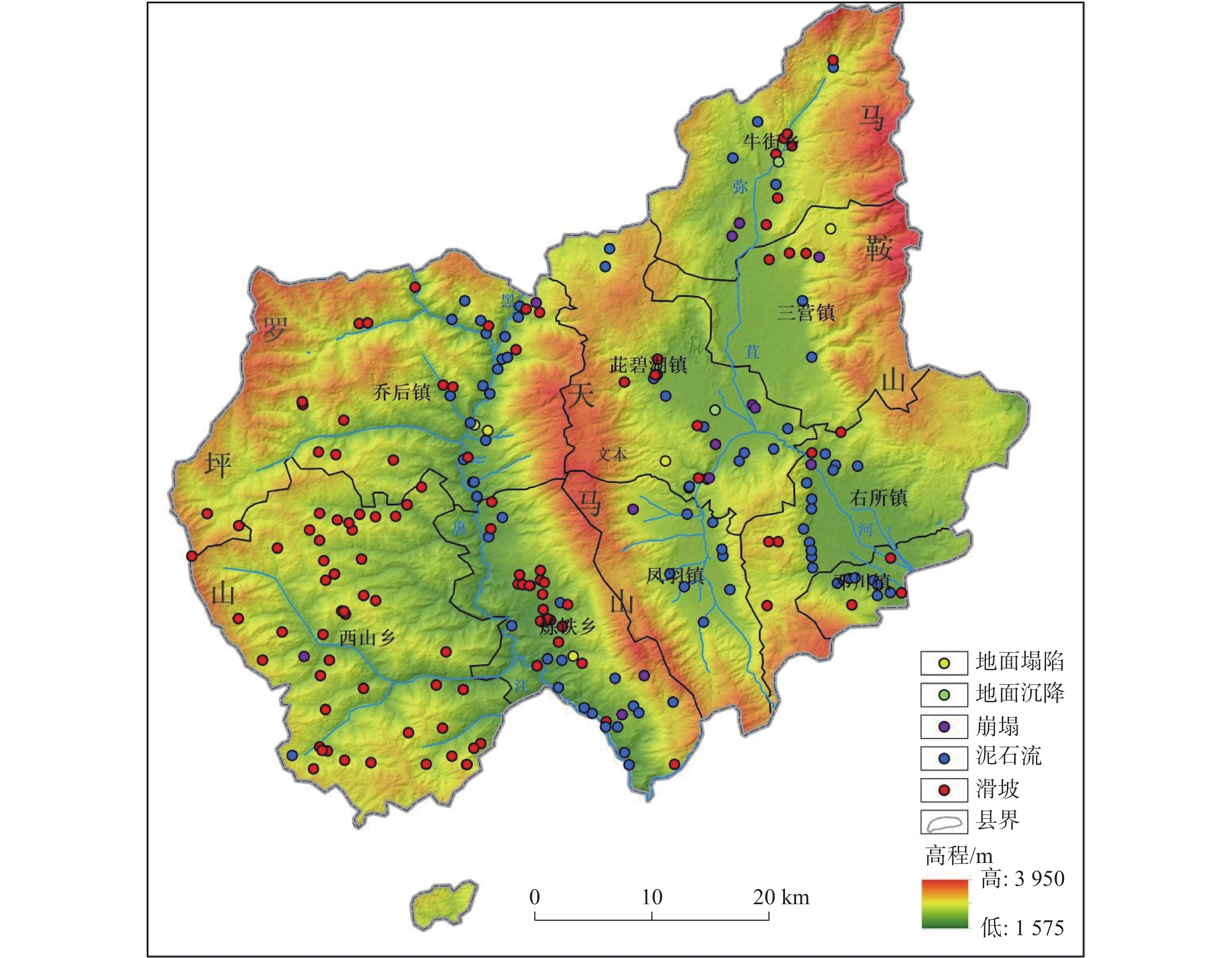
摘要: 洱源县地质环境复杂脆弱,地貌类型多、地形变化大、生态环境脆弱的特点孕育了区内泥石流地质灾害规模大、威胁对象多、发灾时间集中的灾害特点。2012年以来洱源县地质灾害所造成的人员伤亡以暴雨沟谷型泥石流为主。文章对洱源县近年来的暴雨沟谷型泥石流灾害进行统计,以2021年“9 · 13”洱源县凤羽镇铁甲河支流兰林河及黑龙河两条典型泥石流成功避险案例为例,分析洱源沟谷型泥石流成灾背景及运动特征,对暴雨型泥石流监测预警设备选型布设及模型阈值的设置进行阐述,总结洱源县监测预警预报经验与启示。Abstract:
Eryuan county is located in the northern part of Dali Bai Autonomous Prefecture, Yunnan Province. It borders Heqing county and Binchuan county to the east, Dali City and Yangbi county to the south, Yunlong county to the west, and Jianchuan county to the north. The maximum straight-line distance from east to west is about 80 km, and the maximum straight-line distance from north to south is about 68 km. The circumference of the county is about 340 km. Eryuan county is located at the collision zone between the Indian Plate and the Eurasian Plate, and is strongly influenced by the Himalayan orogeny. Since the Miocene, the plateau has experienced substantial uplift, accompanied by vigorous neotectonic movements. Earthquakes are common in this area due to its complex and varied geological and topographical conditions. The terrain is characterized by significant cutting, with high mountains and deep valleys. Additionally, this area has well-developed water systems, and geological disasters occur frequently in this area. It is a high-risk area for geological disasters in Yunnan Province. Since 2012, casualties resulting from geological disasters in Eryuan have primarily been attributed to rainstorm-induced gully-type debris flows. This type of debris flow disaster in the Tiejia river basin is characterized by sudden heavy rainfall occurring in the early morning, leading to large-scale events at a high level of risk. This area also serves as a site for projects of monitoring and early warning geological disasters. It represents a typical case for studies on gully-type debris flow disasters throughout the entire county. Based on the characteristics of gully-type debris flows in the Tiejia river basin, and in accordance with the Technical Specification for Geological Disasters Monitoring and Early Warning by Combination of Professional and Masses Methods and the Technical Guidelines for Monitoring and Early Warning of Geological Hazards in Yunnan Province (Trial), in this study, we employed rainfall stations and mud water levels as main monitoring sites and data, video monitoring stations as auxiliary monitoring sites, and warning broadcasting stations as sites for on-site warning techniques. We analyzed the background and movement characteristics of debris flow disasters in the Eryuan gully. Additionally, we selected a warning model based on the similarities in geological environment and the differences in disaster conditions between the gullies of the Lanlin river and of the Heilong river. Because the main gully of the Lanlin river is shorter than that of the Heilong river, has a smaller drainage area, and features a flatter gully, we adopted a single-parameter warning model to ensure response time. Besides, the development of the main gully of the Heilong river is more tortuous and complex, and it covers a larger watershed area; therefore, we adopted a multi-parameter warning model to reduce the false alarming rate. Based on the analysis of the early warning results of the two gullies of debris flows, and the selection and layout of monitoring and early warning equipment for rainstorm-induced debris flows, we illuminated the setting of model thresholds, and summarized the experience and enlightenment of monitoring and early warning debris flows in Eryuan. The gully debris flows triggered by sudden heavy rainfall are often large in scale, possess strong destructive power, have a brief duration of occurrence, and threaten numerous objects. This presents a key challenge in the prevention of geological disasters in Eryuan county. In the work of monitoring and early warning, we should focus on the monitoring of the strong rainfall that triggers debris flows upstream and the flood flows that causes disasters in the middle and downstream areas of the debris flows. In the work of early warning response, we should identify the main threat after the disaster, and ensure that the deployed warning equipment and warning information are transmitted in a timely manner. We should comprehensively set warning thresholds and models, based on the characteristics of disasters. We should also prioritize the resettlement of evacuees and its regulation. Even if we have implemented projects of controlling debris flows, it is likely to occur debris flows under the influence of extremely heavy rainfall, especially the rainstorm-induced gully-type debris flows taking place in the Tiejia river. Projects of monitoring and early warning can still serve as an effective supplementary measure for engineering management after disaster treatment, so as to enhance the capabilities of comprehensive prevention and control of debris flows. -
Key words:
- geological hazards /
- monitoring methods /
- monitoring and warning /
- Eryuan, Yunnan /
- debris flow
-
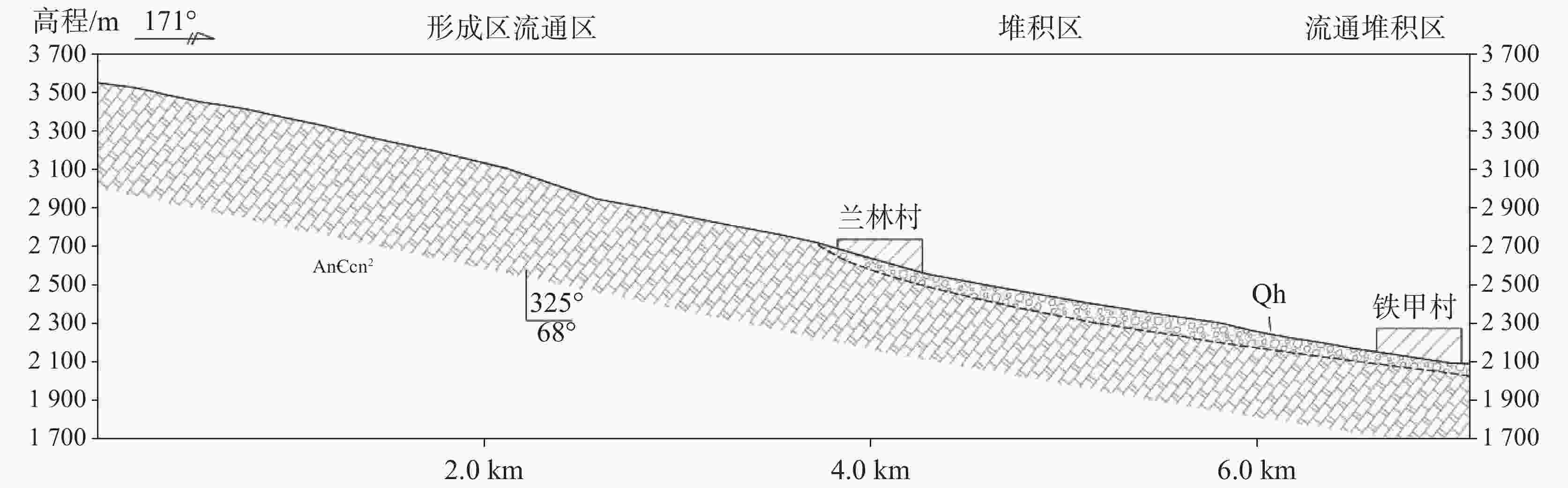
图 2 铁甲河泥石流纵坡变化分区剖面图
Figure 2. Sectional map of longitudinal slope variation of debris flows of the Tiejia river

1 铁甲河泥石流沟系各区典型景观照片
1. Typical landscape of each zone in the debris flow gullies of the Tiejia river
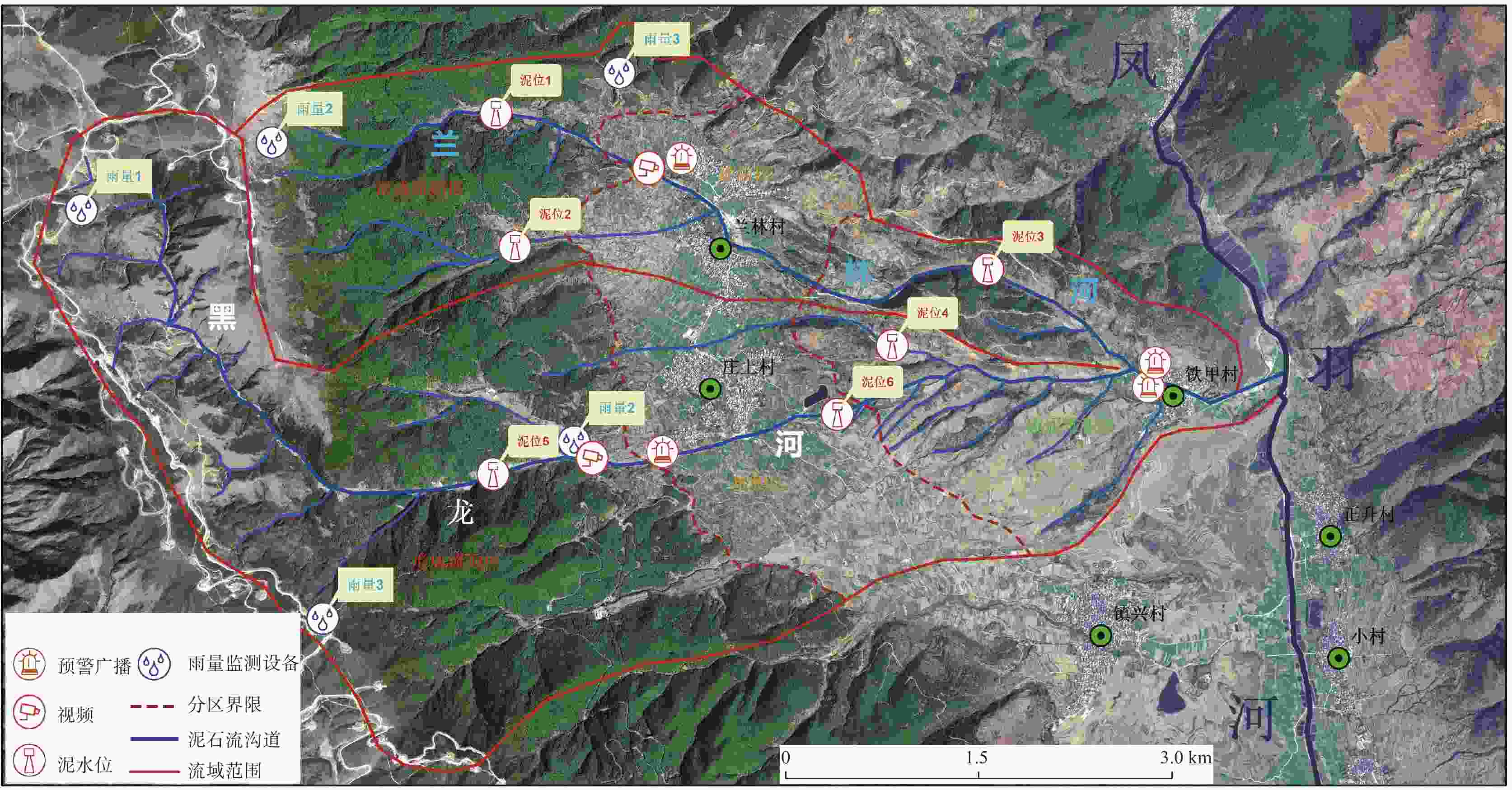
图 3 铁甲河泥石流沟系泥石流分区及监测网点布设图
Figure 3. Zoning of debris flows and layout of monitoring network of debris flow gullies of the Tiejia River
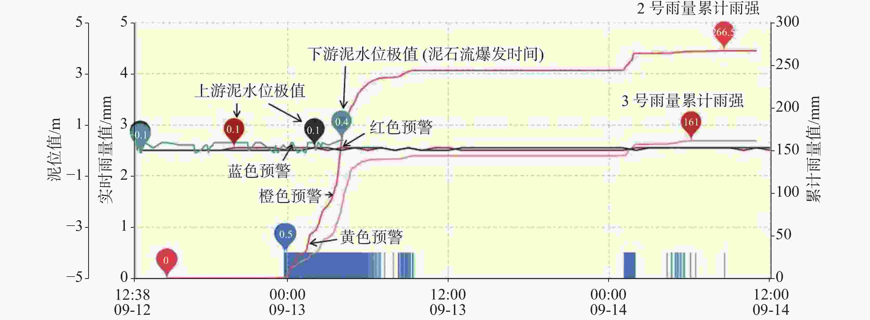
图 4 铁甲河泥石流沟系兰林河泥石流雨量、泥水位监测综合分析图
Figure 4. Comprehensive analysis of monitoring rainfall and water levels of debris flows in the Lanlin river of debris flow gullies of the Tiejia river
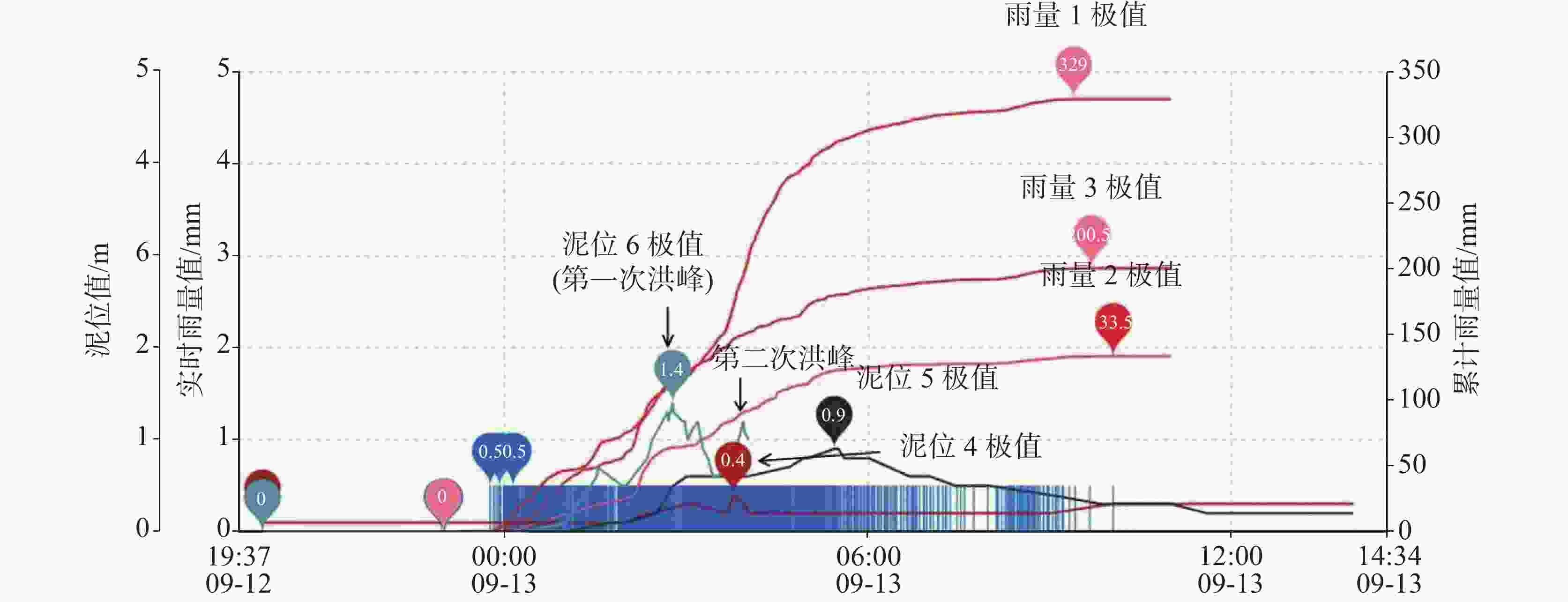
图 5 铁甲河泥石流沟系黑龙河泥石流雨量、泥水位监测综合分析图
Figure 5. Comprehensive analysis of monitoring rainfall and water levels of debris flows in the Heilong river of debris flow gullies of the Tiejia river
表 1 洱源县滑坡及泥石流灾情统计表
Table 1. Statistics of landslides and debris flows in Eryuan
灾害类型 发灾次数/次 人员受伤/人 经济财产损失/万元 6月 7月 8月 9月 失踪 死亡 受伤 滑坡 0 0 2 2 0 0 0 2269.89 泥石流 1 1 2 10 0 6 39 79071.1  下载: 导出CSV
表 2 铁甲河泥石流沟系兰林河与黑龙河分区表
Table 2. Zoning of the Lanlin river and the Heilong river in the system of debris flow gullies of the Tiejia river
分区 形成流通区 堆积区 流通堆积区 海拔 3480 ~2500 m2500 ~2300 m2300 ~2136.5 m分区特征 地形以陡坡−缓坡为主,沟谷呈上缓下陡的“V”形,谷坡坡度多为25°~60°,局部达60°~90°,沟床宽度多在25~50 m ,主沟平均纵坡降约 305‰,出露的岩体节理裂隙发育、破碎,出露的第四系残坡积物厚度一般1~3 m,最大近4 m。 地势相对平缓,地形坡度在15°~ 20°,平均纵坡降约90‰,沟谷呈“U”字型,沟道宽约15~30 m,沟内以碎块石、砂砾石为主,形成堆积扇,中下部自沟口向堆积扇前缘地形逐渐变缓。 位于铁甲村至花平、小庄村区域。地形坡度在25°~35°,河段河谷狭窄,沟宽1~3 m,沟内冲洪积堆积物较少,沟岸稳定,堆积物经流通堆积致铁甲村周围。
下载: 导出CSV
表 3 铁甲河泥石流沟系兰林河与黑龙河已建工程表
Table 3. Projects established along the Lanlin river and the Heilong river of debris flow gullies of the Tiejia river
沟 名 治理工程 监测预警工程 防治状况 拦渣坝
/座谷坊坝
/座V型排导
槽/m雨量站
/台泥位计
/套视频
/套广播站
/套兰林河 6 9 815 2 3 1 2 拦挡工程均已满库部分拦挡工程、排导槽、两沟下游2台泥位监测站、2台预警广播站在2021年泥石流灾害中被不同程度损坏 黑龙河 7 8 1195 3 5(含恢复
泥水位)1 2
下载: 导出CSV
-
[1] 王梓桐. 云南省大理市地质灾害研究[D]. 北京:中国地质大学, 2021.WANG Zitong. Study on geological hazards in Dali City, Yunnan Province[D]. Beijing: China University of Geosciences, 2021. [2] 云南省地质环境监测院. 县(市)地质灾害调查综合研究与信息系统建设成果报告[R]. 2010. [3] 刘传正. 中国崩塌滑坡泥石流灾害成因类型[J]. 地质论评, 2014, 60(4):858-868.LIU Chuanzheng. Genetic types of landslide and debris flow disasters in China[J]. Geological Review, 2014, 60(4): 858-868. [4] 袁道先. 西南岩溶石山地区重大环境地质问题及对策研究[M]. 北京:科学出版社, 2014:3-14. [5] 常祖峰, 张艳凤, 周青云, 虎雄林, 臧阳. 2013 年洱源MS5.5地震烈度分布及震区活动构造背景研究[J]. 中国地震, 2014, 30(4):560-570. doi: 10.3969/j.issn.1001-4683.2014.04.009CHANG Zufeng, ZHANG Yanfeng, ZHOU Qingyun, HU Xionglin, ZANG Yang.Intensity distribution characteristics and active tectonic background in area of the 2013 EryuanMS5.5 earthquake[J].Earthquake Research in China, 2014, 30(4): 560-570. doi: 10.3969/j.issn.1001-4683.2014.04.009 [6] 殷跃平. 汶川八级地震地质灾害研究[J]. 工程地质学报, 2008, 16(4):433-444. doi: 10.3969/j.issn.1004-9665.2008.04.001YIN Yueping. Researches on the geo-hazards triggered by Wenchuan earthquake, Sichuan[J]. Journal of Engineering Geology, 2008, 16(4): 433-444. doi: 10.3969/j.issn.1004-9665.2008.04.001 [7] 王宇. 云南省崩塌滑坡泥石流灾害及防治[J]. 地质灾害与环境保护, 1998, 9(4):38-47.WANG Yu. Hazards collapse landslide and debris flow in Yunnan and their control[J]. Geological Hazards and Environment Protection, 1998, 9(4): 38-47. [8] 王宇. 云南省地质灾害防治与研究历史评述[J]. 灾害学, 2019, 34(3):134-139. doi: 10.3969/j.issn.1000-811X.2019.03.025WANG Yu. Historical review of geological disaster prevention and research in Yunnan Province, China[J]. Journal of Catastrophology, 2019, 34(3): 134-139. doi: 10.3969/j.issn.1000-811X.2019.03.025 [9] 王宇, 祝传兵, 张杰, 杨迎冬, 黄成. 云南高原山区地质灾害与应急地质工作方法[M]. 昆明:云南科技出版社, 2020:37-45. [10] 唐川. 云南省地理研究所滑坡泥石流研究10年[J]. 云南地理环境研究, 1998, 10(Suppl.1):33-40. [11] 云南省地质环境监测院. 县(市)地质灾害调查综合研究与信息系统建设成果报告[R]. 2010.Yunnan Provincial Institute of Geological Environment Monitoring. Report on Comprehensive Research and Information System Construction Results of County (City) Geological Disaster Investigation [R]. 2010. [12] 赵石锁. 云南省洱源县地质灾害成因机制及危险性区划[D]. 北京:中国地质大学, 2016.ZHAO Shisuo. Research on formation and division of geological disaster in Eryuan county, Yunnan Province[D]. Beijing: China University of Geosciences, 2016. [13] 张小趁, 陈红旗. 突发地质灾害应急技术过程模式[J]. 灾害学, 2015, 30(4):149-155. doi: 10.3969/j.issn.1000-811X.2015.04.028ZHANG Xiaochen, CHEN Hongqi. Geological disaster emergency technology: Process model[J]. Journal of Catastrophology, 2015, 30(4): 149-155. doi: 10.3969/j.issn.1000-811X.2015.04.028 [14] 张红兵, 金德山. 影响云南省滑坡泥石流活动的几个自然因素[J]. 水文地质工程地质, 2004(5):38-41. doi: 10.3969/j.issn.1000-3665.2004.05.009ZHANG Hongbing, JIN Deshan. Several natural factors influencing on activity of landslide and debris flow in Yunnan Province[J]. Hydrogeology and Engineering Geology, 2004(5): 38-41. doi: 10.3969/j.issn.1000-3665.2004.05.009 [15] 杨迎冬, 晏祥省, 王宇, 汤沛, 魏蕾, 赵鹏, 黄成. 云南省地质灾害特征及形成规律研究[J]. 灾害学, 2021, 36(3):131-139. doi: 10.3969/j.issn.1000-811X.2021.03.023YANG Yingdong, YAN Xiangsheng, WANG Yu, TANG Pei, WEI Lei, ZHAO Peng, HUANG Cheng. The characteristics and formation of geological hazards in Yunnan Province[J]. Journal of Catastrophology, 2021, 36(3): 131-139. doi: 10.3969/j.issn.1000-811X.2021.03.023 [16] 何瑞翔, 林齐根, 王瑛, 宋祟振. 云南省地质灾害影响因素及高危险区分析[J]. 灾害学, 2015, 30(3):208-213. doi: 10.3969/j.issn.1000-811X.2015.03.038HE Ruixiang, LIN Qigen, WANG Ying, SONG Chongzhen. Factors and high risk area analysis of geological hazards in Yunnan[J]. Journal of Catastrophology, 2015, 30(3): 208-213. doi: 10.3969/j.issn.1000-811X.2015.03.038 [17] 龚红胜, 朱杰勇, 陈刚. 昆明市活动断裂与地质灾害关系的探讨[J]. 中国地质灾害与防治学报, 2006, 17(3):161-164. doi: 10.3969/j.issn.1003-8035.2006.03.039 [18] 云南地质工程第二勘察院大理分院. 云南省 2020 年度大理州地质灾害监测预警体系建设(总承建)A包实施方案[R]. 2021. [19] 地质灾害应急联合调查组. 洱源县“9 · 13”大型山洪泥石流灾害应急调查报告[R]. 2021. [20] 杨迎冬, 汤沛, 肖华宗, 晏祥省. 云南省地质灾害与水系关系初步分析[J]. 灾害学, 2017, 32(3):36-39. doi: 10.3969/j.issn.1000-811X.2017.03.007YANG Yingdong, TANG Pei, XIAO Huazong, YAN Xiangsheng. Preliminary analysis on relationships between geo-hazards and river systems of Yunnan Province[J]. Journal of Catastrophology, 2017, 32(3): 36-39. doi: 10.3969/j.issn.1000-811X.2017.03.007 [21] 刘传正, 温铭生, 刘艳辉, 刘秋强, 顾笑筱. 汶川地震区地质灾害成生规律研究[J]. 水文地质工程地质, 2016, 43(5):1-16.LIU Chuanzheng, WEN Mingsheng, LIU Yanhui, LIU Qiuqiang, GU Xiaoxiao. Regional assessment on geological disasters in "5.12" Wenchuan seismic Area, China[J]. Hydrogeology & Engineering Geology, 2016, 43(5): 1-16. [22] 王宇, 杨迎冬, 晏祥省, 汤沛, 张杰. 云南鲁甸6.5级地质次生特大地质灾害的特征及原因[J]. 灾害学, 2016, 31(1):83-86. doi: 10.3969/j.issn.1000-811X.2016.01.017WANG Yu, YANG Yingdong, YAN Xiangsheng, TANG Pei, ZHANG Jie. Characteristics and causes of super-huge secondary geological hazards by M6.5 Ludian earthquake in Yunnan[J]. Journal of Catastrophology, 2016, 31(1): 83-86. doi: 10.3969/j.issn.1000-811X.2016.01.017 [23] 徐继维, 张茂省. 泥石流风险评估综述[J]. 灾害学, 2016, 31(4):157-161. doi: 10.3969/j.issn.1000-811X.2016.04.027XU Jiwei, ZHANG Maosheng. A review of debris flow risk assessment[J]. Journal of Catastrophology, 2016, 31(4): 157-161. doi: 10.3969/j.issn.1000-811X.2016.04.027 [24] 刘传正, 刘艳辉, 温铭生, 唐灿, 薛群威. 中国地质灾害区域预警方法与应用[M]. 北京:地质出版社, 2009:148-171. -


 点击查看大图
计量
- 文章访问数: 180
- HTML浏览量: 109
- PDF下载量: 35
- 被引次数: 0
