

Research on early warning for meteorological risks of rainfall-induced landslide hazards in typical areas of southwest Yunnan
-
摘要: 基于易发性评价和降雨阈值分析,建立降雨诱发的滑坡危险性预警模型,能有效为区域滑坡灾害风险预警工作提供支持。文章以滑坡灾害频发的滇西南隆阳区—芒市段为研究对象,采用随机森林模型进行滑坡灾害易发性评价,分析降雨与滑坡之间的耦合关系,进而构建降雨阈值模型,通过时空等级耦合分析划分气象风险预警等级,经实际灾情数据验证,模型有较好的可靠性。Abstract:
The area of Longyang district–Mangshi section is located in the middle and lower reaches of the Nujiang river and the Daying river. The landform in this area is dominated by medium mountains, wide valleys, and basins. This area is characterized by a southern subtropical monsoon climate and a southern subtropical mountain monsoon climate. The overall structural features within the area are composed of a series of near north-south faults, and their derived secondary transverse tensile faults as well as tight folds. Lithology is mainly composed of metamorphic rock strata in the Proterozoic Gaoligong mountains, strata from the Paleozoic to the Mesozoic, and clay, fragments, gravel from the Quaternary. The study area is typically concentrated and developed with rainfall-induced landslides, and geological disasters mainly include collapses, landslides, debris flows and ground subsidence. Among these disasters, there are 1,175 landslide events, with rainfall-induced landslides accounting for over 95%. This type of disaster is the most significant in the study area. Water systems are intensively distributed in this area, with large depths of river valleys, and a pronounced variation in terrain. Landslide hazards are mainly distributed along valleys on both sides of rivers. Based on the assessment of vulnerability and the analysis of rainfall thresholds, an early warning model for rainfall-induced landslide risks has been established. This model can effectively support early warnings for regional landslide risks. The study area is located in the section of Longyang district–Mangshi section in southwest Yunnan Province, which is prone to frequent landslide hazards. This study employed Pearson correlation coefficient to analyze the relationships among various evaluation factors. A total of 13 evaluation factors, including elevation, slope and slope direction, were selected, and grid units measuring 100 m×100 m were divided. The random forest model was employed to evaluate the vulnerability of landslide hazards and the area under curve (AUC) was utilized to verify the accuracy of the model. Then, by analyzing the coupling relationship between landslides and rainfall, the early effective rainfall intensity (EI) was calculated. The EI and rainfall duration (D) were used as the horizontal and vertical coordinates respectively, to create a double-logarithmic coordinate system. This system illustrated the scatter distribution of the probability of landslide occurrence time and allowed for the fitting of the EI-D threshold curve according to the classification standards for landslide warning grades. Subsequently, a rainfall threshold model was created. Finally, the susceptibility classification region and the EI-D rainfall threshold were superimposed and combined to establish early warning levels for meteorological risks of rainfall-induced landslides based on the EI-D rainfall threshold. Research findings indicate that the AUC value of the training results for the random forest model is 0.84. This suggests that the model selection is appropriate and that the susceptibility evaluation results are reliable. An EI-D rainfall threshold model has been developed, and four EI-D rainfall threshold curves have been fitted. In conjunction with the evaluation results of the vulnerability of the study area, a dynamic evaluation model for landslide risks based on the EI-D rainfall threshold has been established. This model can serve as a reference for early warning evaluations of meteorological risks in the study area. -
Key words:
- random forest /
- landslide /
- rainfall /
- susceptibility evaluation /
- risk warning /
- southwest Yunnan
-

图 6 研究区月平均降雨与滑坡发生频次图
Figure 6. Monthly average rainfall and frequency of landslides in the study area
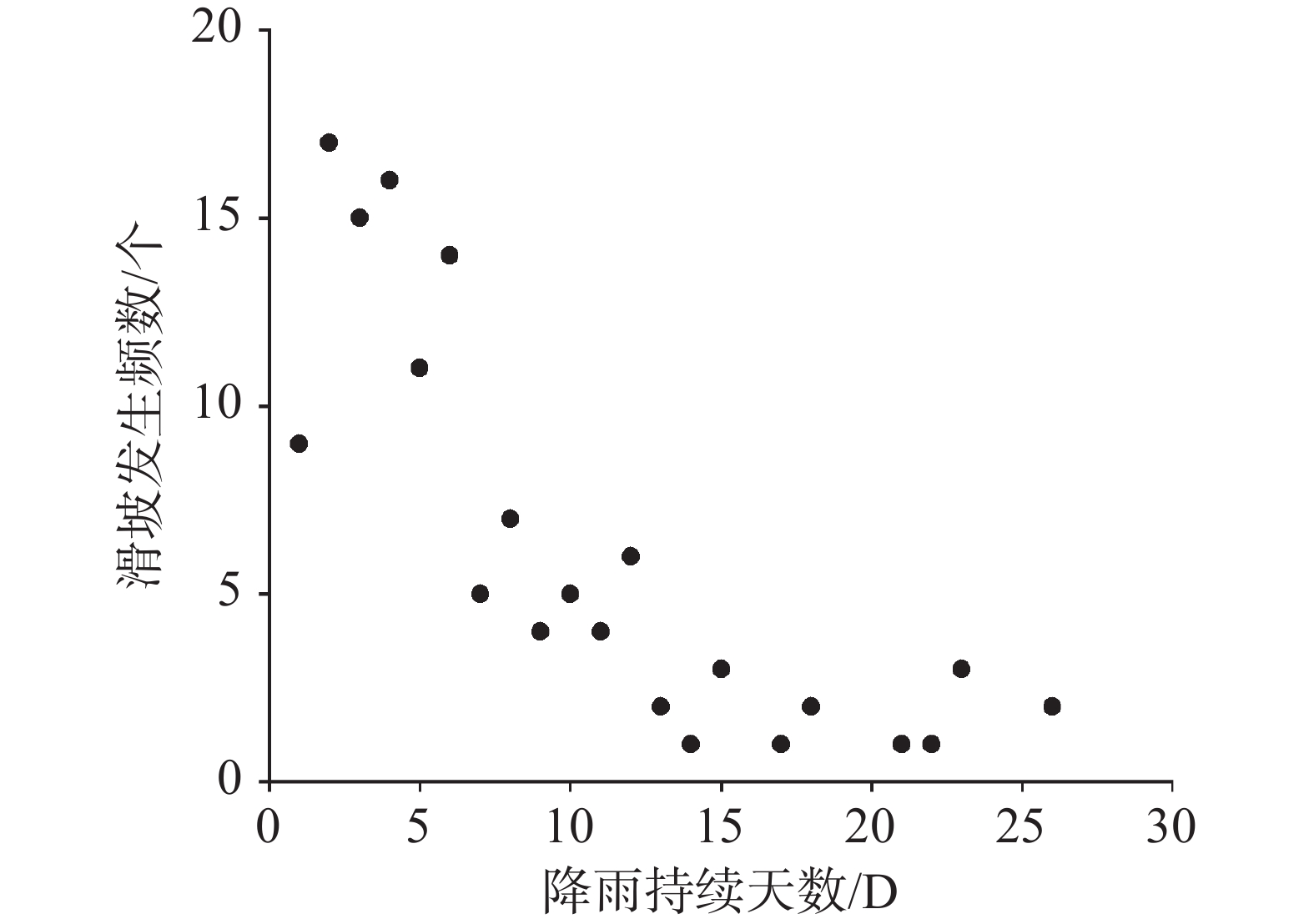
图 7 连续降雨天数与灾害发生次数关系图
Figure 7. Relationship between the number of continuous rainfall days and the number of disasters
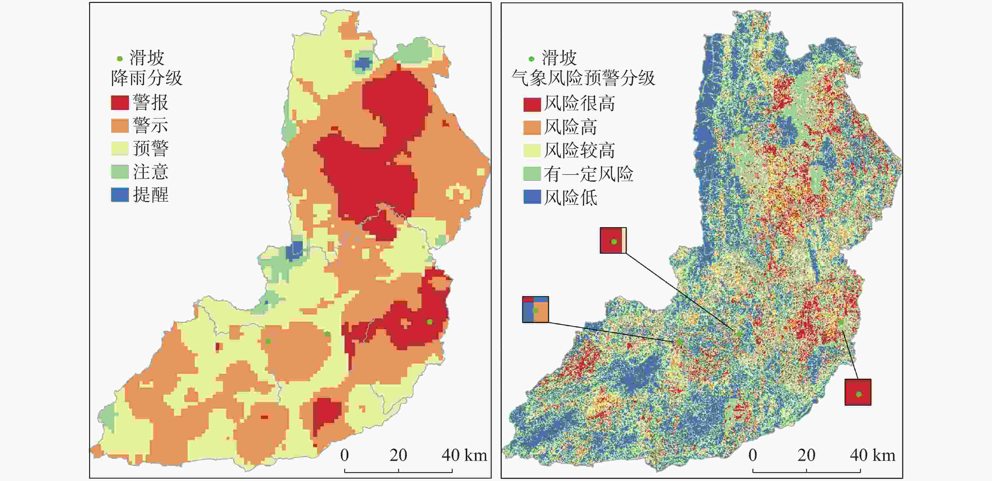
图 9 2020年8月19日各降雨阈值级别及预警图
Figure 9. Each rainfall threshold and map of early warning on 19 August, 2020
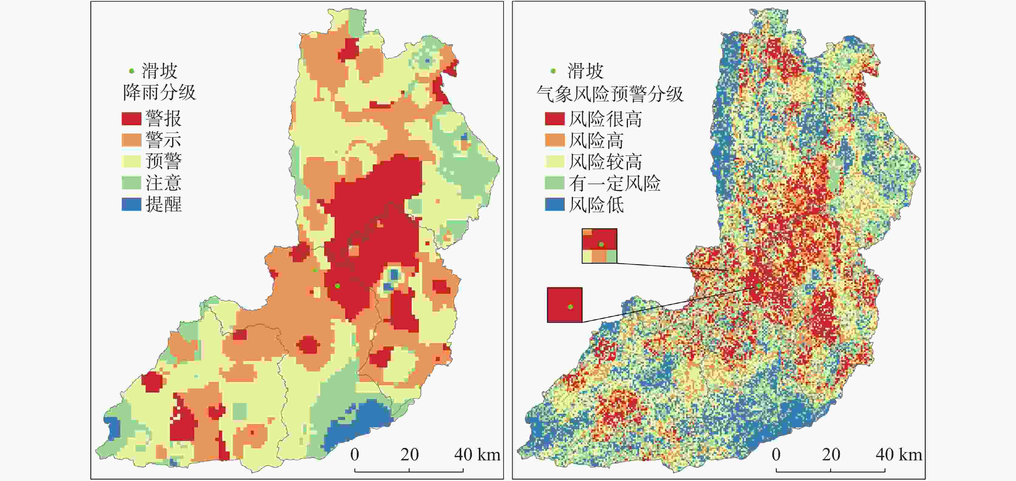
图 10 2021年7月25日各降雨阈值级别及预警图
Figure 10. Each rainfall threshold and map of early warning on 25 July, 2021
表 1 训练得到的最优超参数值
Table 1. Optimal hyperparameter values obtained by training
超参数 含义 n_estimators 70 criterion gini min_samples_split 8 max_depths 22 max_features 3 min_samples_leaf 8 bootstrap True  下载: 导出CSV
表 2 滑坡事件当日降雨级别分布
Table 2. Distribution of rainfall levels on the day of landslide occurrence
雨量分级/mm 无雨
(0)小雨
(<10)中雨
(10~25)大雨
(25~50)暴雨
(≥50)滑坡发生占比/% 3% 29% 23% 20% 25%
下载: 导出CSV
表 3 降雨阈值等级划分表
Table 3. Classification of rainfall threshold levels
等级划分 T1 T2 T3 T4 T5 滑坡发生概率/% ≤20 20~40 40~60 60~80 >80
下载: 导出CSV
表 4 气象风险预警分级表
Table 4. Grading of early warning for meteorological risks
预警级别 T1 T2 T3 T4 T5 S1 风险低 风险低 风险低 风险低 有一定风险 S2 风险低 风险低 有一定风险 有一定风险 风险较高 S3 风险低 有一定风险 风险较高 风险较高 风险高 S4 风险低 有一定风险 风险较高 风险高 风险很高 S5 有一定风险 风险较高 风险高 风险很高 风险很高
下载: 导出CSV
表 5 各降雨事件下的气象风险预警等级
Table 5. Early warning levels of meteorological risk in each rainfall event
发生时间 D EI EI-D降雨阈值等级 易发性等级 气象风险预警等级 2020/8/19 12 14.59 T4 S5 风险高 11 13.39 T4 S5 风险很高 3 34.66 T5 S5 风险很高 2021/7/25 7 15.67 T4 S5 风险很高 1 99.14 T5 S5 风险很高
下载: 导出CSV
-
[1] 黄润秋. 20世纪以来中国的大型滑坡及其发生机制[J]. 岩石力学与工程学报, 2007, 26(3):433-454.HUANG Runqiu. Large-scale landslides and their sliding mechanisms in China since the 20th century[J]. Chinese Journal of Rock Mechanics and Engineering, 2007, 26(3): 433-454. [2] 中华人民共和国国土资源部. 全国地质灾害通报[R]. 2021.Ministry of Land and Resources of the People's Republic of China. China Geological Hazard Bulletin[R]. 2021. [3] 吴益平, 张秋霞, 唐辉明, 肖威. 基于有效降雨强度的滑坡灾害危险性预警[J]. 地球科学(中国地质大学学报), 2014, 39(7):889-895. doi: 10.3799/dqkx.2014.083WU Yiping, ZHANG Qiuxia, TANG Huiming, XIAO Wei. Landslide hazard warning based on effective rainfall intensity[J]. Earth Science (Journal of China University of Geosciences), 2014, 39(7): 889-895. doi: 10.3799/dqkx.2014.083 [4] Alireza Arabameri, Biswajeet Pradhan, Luigi Lombardo. Comparative assessment using boosted regression trees, binary logistic regression, frequency ratio and numerical risk factor for gully erosion susceptibility modelling[J]. Catena, 2019, 183(20): 104223. [5] R C Wilson. Rainstorms, pore pressures, and debris flows: A theoretical framework[J]. Landslides in a Semi-arid Environment, 1989, 2(4): 101-117. [6] R C Wilson, G F Wieczorek. Rainfall thresholds for the initiation of debris flows at La Honda, California[J]. Environmental and Engineering Geoscience, 1995, 1(1): 11-27. [7] Bartelletti Carlotta, Avanzi Giacomo D'Amato, Galanti Yuri, Giannecchini Roberto, Mazzali Alberto. Assessing shallow landslide susceptibility by using the SHALSTAB model in Eastern Liguria (Italy)[J]. Rendiconti Online Societa Geologica Italiana, 2015, 35(134): 17-20. [8] Taizo Endo. Probable distribution of the amount of rainfall causing landslides[J]. Bulletin of the Disaster Prevention Research Institute, 1970,20(1):141-150. [9] T Onodera, R Yoshinaka, H Kazama. Slope failures caused by heavy rainfall in Japan[J]. Journal of the Japan Society of Engineering Geology, 1974, 15(4): 191-200. doi: 10.5110/jjseg.15.191 [10] 谢剑明, 刘礼领, 殷坤龙, 杜惠良, 纽学新. 浙江省滑坡灾害预警预报的降雨阀值研究[J]. 地质科技情报, 2003, 22(4):101-105.XIE Jianming, LIU Liling, YIN Kunlong, DU Huiliang, NIU Xuexin. Study on the threshold values of rainfall of land slide hazards for early-warning and prediction in Zhejiang Province[J]. Geological Science and Technology Information, 2003, 22(4): 101-105. [11] 陈洪凯, 魏来, 谭玲. 降雨型滑坡经验性降雨阈值研究综述[J]. 重庆交通大学学报(自然科学版), 2012, 31(5):990-996.CHEN Hongkai, WEI Lai, TAN Ling. Review of research on empirical rainfall threshold of rainfall-induced landslide[J]. Journal of Chongqing Jiaotong University (Natural Science), 2012, 31(5): 990-996. [12] 黄发明, 陈佳武, 范宣梅, 黄劲松, 周创兵. 降雨型滑坡时间概率的逻辑回归拟合及连续概率滑坡危险性建模[J]. 地球科学, 2022, 47(12):4609-4628.HUANG Faming, CHEN Jiawu, FAN Xuanmei, HUANG Jingsong, ZHOU Chuangbing. Logistic regression fitting of rainfall-induced landslide occurrence probability and continuous landslide hazard prediction modelling[J]. Earth Science, 2022, 47(12): 4609-4628. [13] Nel Caine. The rainfall intensity–duration control of shallow landslides and debris flows[J]. Geografiska Annaler Series A: Physical Geography, 1980, 62(1): 23-27. [14] F Guzzetti, S Peruccacci, M Rossi, C P Stark. Rainfall thresholds for the initiation of landslides in central and southern Europe[J]. Meteorology and Atmospheric Physics, 2007, 98(3): 239-267. [15] John Mathew, D Giri Babu, S Kundu, K Vinod Kumar, C C Pant. Integrating intensity–duration-based rainfall threshold and antecedent rainfall-based probability estimate towards generating early warning for rainfall-induced landslides in parts of the Garhwal Himalaya, India[J]. Landslides, 2013, 11(4): 575-588. [16] 王新伟, 张漓黎, 莫德科, 叶宗达, 江凡. 基于信息量和多层感知机分类器模型耦合的平果市斜坡类地质灾害易发性评价[J]. 中国岩溶, 2023, 42(2):370-381.WANG Xinwei, ZHANG Lili, MO Deke, YE Zongda, JIANG Fan. Hillslope geo-hazard susceptibility assessment in Pingguo City based on coupling of CF information value and MLPC classifier model[J]. Carsologica Sinica, 2023, 42(2): 370-381. [17] 郭子正, 殷坤龙, 黄发明, 付圣, 张文. 基于滑坡分类和加权频率比模型的滑坡易发性评价[J]. 岩石力学与工程学报, 2019, 38(2):287-300.GUO Zizheng, YIN Kunlong, HUANG Faming, FU Sheng, ZHANG Wen. Evaluation of landslide susceptibility based on landslide classification and weighted frequency ratio model[J]. Chinese Journal of Rock Mechanics and Engineering, 2019, 38(2): 287-300. [18] Paraskevas Tsangaratos, Constantinos Loupasakis, Konstantinos Nikolakopoulos, Varvara Angelitsa, Loanna Ilia. Developing a landslide susceptibility map based on remote sensing, fuzzy logic and expert knowledge of the Island of Lefkada, Greece[J]. Environmental Earth Sciences, 2018, 77(10): 363. [19] C Gokceoglu. Discussion on "Combining landslide susceptibility maps obtained from frequency ratio, logistic regression, and artificial neural network models using ASTER images and GIS" by Choi et al[J]. Engineering Geology, 2012, 129-130: 104-105. [20] Li Yongwei, Wang Xianmin, Mao Hang. Influence of human activity on landslide susceptibility development in the Three Gorges area[J]. Natural Hazards, 2020, 104(3): 2115-2151. [21] 吴润泽, 胡旭东, 梅红波, 贺金勇, 杨建英. 基于随机森林的滑坡空间易发性评价:以三峡库区湖北段为例[J]. 地球科学, 2021, 46(1):321-330.WU Runze, HU Xudong, MEI Hongbo, HE Jinyong, YANG Jianying. Spatial susceptibility assessment of landslides based on random forest: A case study from Hubei section in the Three Gorges Reservoir Area[J]. Earth Science, 2021, 46(1): 321-330. [22] 杨迎冬, 汤沛, 肖华宗, 晏祥省. 云南省地质灾害与水系关系初步分析[J]. 灾害学, 2017, 32(3):36-39. doi: 10.3969/j.issn.1000-811X.2017.03.007YANG Yingdong, TANG Pei, XIAO Huazong, YAN Xiangsheng. Preliminary analysis on relationships between geo-hazards and river systems of Yunnan Province[J]. Journal of Catastrophology, 2017, 32(3): 36-39. doi: 10.3969/j.issn.1000-811X.2017.03.007 [23] 董师师, 黄哲学. 随机森林理论浅析[J]. 集成技术, 2013, 2(1):1-7.DONG Shishi, HUANG Zhexue. A brief theoretical overview of random forests[J]. Journal of Integration Technology, 2013, 2(1): 1-7. [24] Dennis M Staley, Joseph E Gartner, Jason W Kean. Objective definition of rainfall intensity–duration thresholds for post-fire flash floods and debris flows in the area burned by the Waldo Canyon Fire, Colorado, USA[J]. Springer International Publishing, 2015(2): 621-624. [25] 鲍其云, 麻土华, 李长江, 王保欣. 浙江62个丘陵山区县引发滑坡的降雨强度−历时阈值[J]. 科技通报, 2016, 32(5):48-55, 95.BAO Qiyun, MA Tuhua, LI Changjiang, WANG Baoxin. Rainfall intensity–duration thresholds for the initiation of landslides in 62 hilly and mountainous counties of Zhejiang Province[J]. Bulletin of Science and Technology, 2016, 32(5): 48-55, 95. [26] 胡娟, 闵颖, 李华宏, 李湘, 李超, 李磊. 云南省山洪地质灾害气象预报预警方法研究[J]. 灾害学, 2014, 29(1):62-66.HU Juan, MIN Ying, LI Huahong, LI Xiang, LI Chao, LI Lei. Meteorological early-warning research of mountain torrent and geologic hazard in Yunnan Province[J]. Journal of Catastrophology, 2014, 29(1): 62-66. [27] 曹中山. 基于易发性和临界降雨阈值的滑坡危险性预警建模研究[D]. 南昌:南昌大学, 2020.CAO Zhongshan. Study on landslide risk warning modeling based on sensitivity and critical rainfall threshold[D]. Nanchang: Nanchang University, 2020. -


 点击查看大图

计量
- 文章访问数: 167
- HTML浏览量: 77
- PDF下载量: 33
- 被引次数: 0
