

Remote sensing interpretation and application of geological environment conditions in early identification of potential geo-hazards: A case study of Huaping county
-
摘要: 地质灾害隐患早期识别的主要任务是从实际的地质环境出发,研判地质环境因素变化可能产生新的地质灾害,对其进行科学预测以降低灾害发生几率。文章在实践工作基础上,结合已有规范、标准,构建由地形地貌、地质构造、地层岩性、水文地质、土地利用、人类活动、不良地质现象7类地质环境条件组成、服务于地质灾害隐患早期识别工作的县域地质环境遥感解译体系,并利用北京二号高分辨率光学遥感影像建立地质环境条件全要素解译标志,完成县域环境地质遥感解译。基于县域地质环境解译结果,总结归纳采用7类地质环境要素解译研判单体隐患的工作内容及步骤,并以云南省丽江市华坪县八德村滑坡隐患为示范案例,展示地质环境遥感解译工作如何服务于单体地质灾害隐患早期识别与风险评价。Abstract:
Huaping county is located in the mountains bordering the Yunnan–Guizhou Plateau and the Qinghai–Xizang Plateau, where geo-hazards occur frequently. In order to understand the background of disaster generation and the laws of their occurrence, as well as to enhance the accuracy of early identification of potential geo-hazards and reduce the likelihood of disasters, this study has developed a county-level system for remote sensing interpretation of the geological environment. This system is designed for the early identification of potential geo-hazards, based on practical work and existing norms and standards. Additionally, this study has established a set of full-element interpretation signs for geological environment conditions in Huaping county by utilizing Beijing-2 High-Resolution Optical Remote Sensing Images, thereby completing the remote sensing interpretation of the geological environment in Huaping county. Based on the interpretation results of the geological environment in this county, this study examines the potential landslide hazards in Bade village, Huaping county, as a case study. It demonstrates how remote sensing interpretation of the geological environment facilitates the early identification and risk assessment of potential geo-hazards occurring in a single geographic unit. The overall findings of this study are as follows: (1) The remote sensing interpretation system of county-level geological conditions, based on potential geo-hazards, can be summarized and classified into seven categories: topography and geomorphology, geological structure, stratum lithology, hydrogeology, land use, human activities, and adverse geological phenomena. (2) With the use of seven categories of geological environment elements, the process of interpreting and assessing potential disasters in a single geographic unit can be summarized as the following steps. First, the characteristics of surface deformation, and indicators of topography and geomorphology were analyzed to determine the activity and the topographic associated with the occurrence of potential geo-hazards. Second, based on the four kinds of indicators of geological structure, stratum lithology, hydrogeological conditions, and adverse geological phenomena, hidden dangers in the disaster environment were assessed. Third, with the use of two indicators of human activities and land use, the type of the hidden bearing body and the associated hazards were evaluated. Finally, the risk level of the hidden danger was evaluated based on the activity and the potential harm involved. It is important to note that this assessment was conducted indoors, and the final risk level must be verified in the field. (3) Conducting a full-element optical remote sensing interpretation of geological environment can rapidly and accurately assess the disaster-bearing conditions of specific geo-hazards in a single geographical unit such as the potential landslides in Badu village, Huaping county. This approach can significantly enhance the accuracy of early identification of potential geo-hazards and holds significant importance for identifying such geo-hazards in the mountainous areas of Southwest China. It is recommended to implement a thorough remote sensing interpretation. -
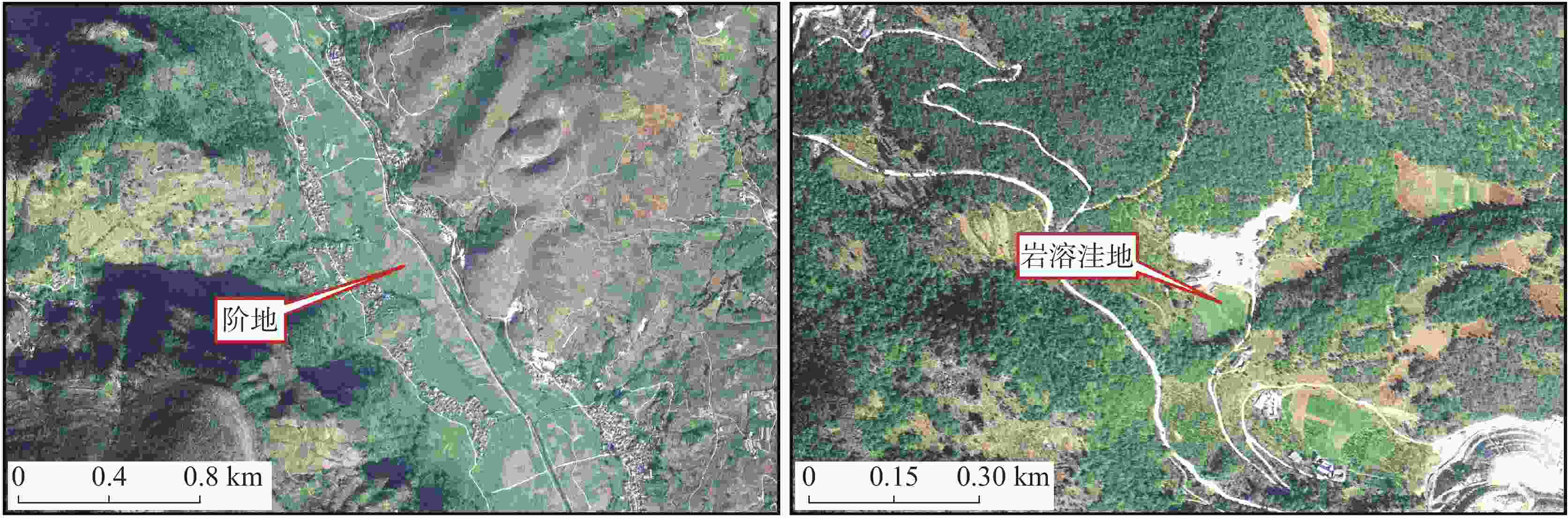
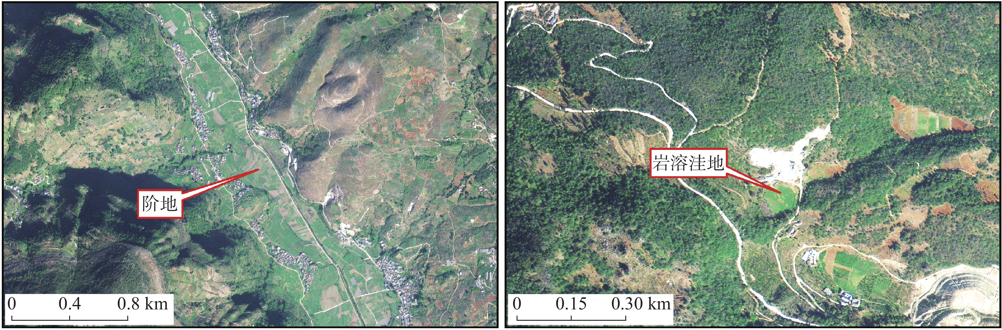
图 1 华坪县典型地形地貌遥感影像图
Figure 1. Remote sensing images of typical landforms in Huaping county
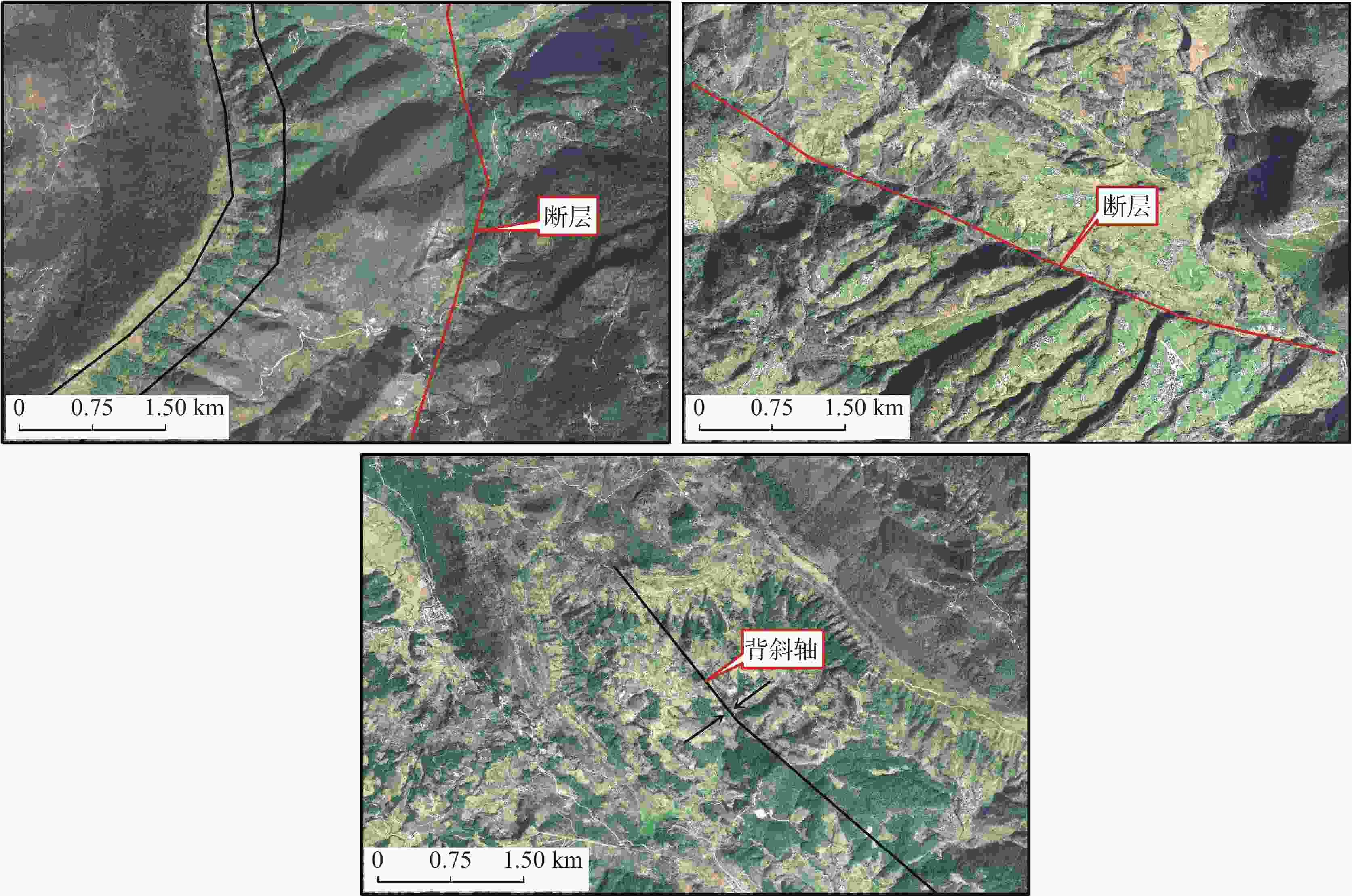
图 2 华坪县典型地质构造遥感影像图
Figure 2. Remote sensing images of typical geological structures in Huaping county
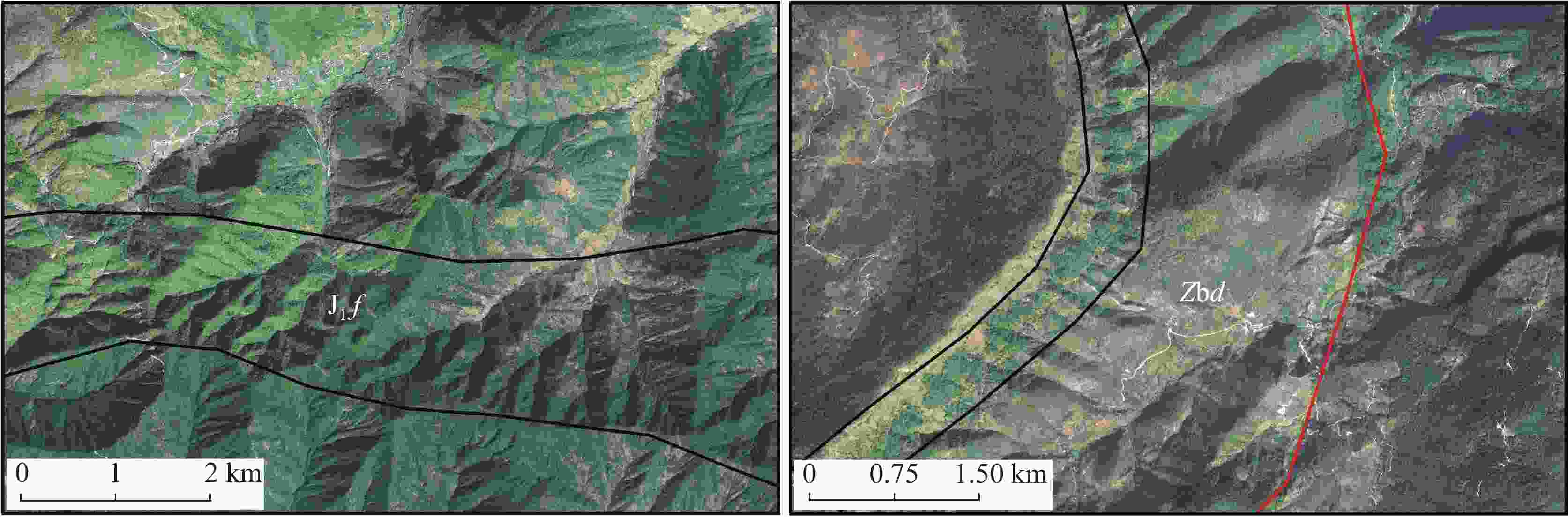
图 3 华坪县典型地层岩性遥感影像图
Figure 3. Remote sensing images of typical lithology in Huaping county
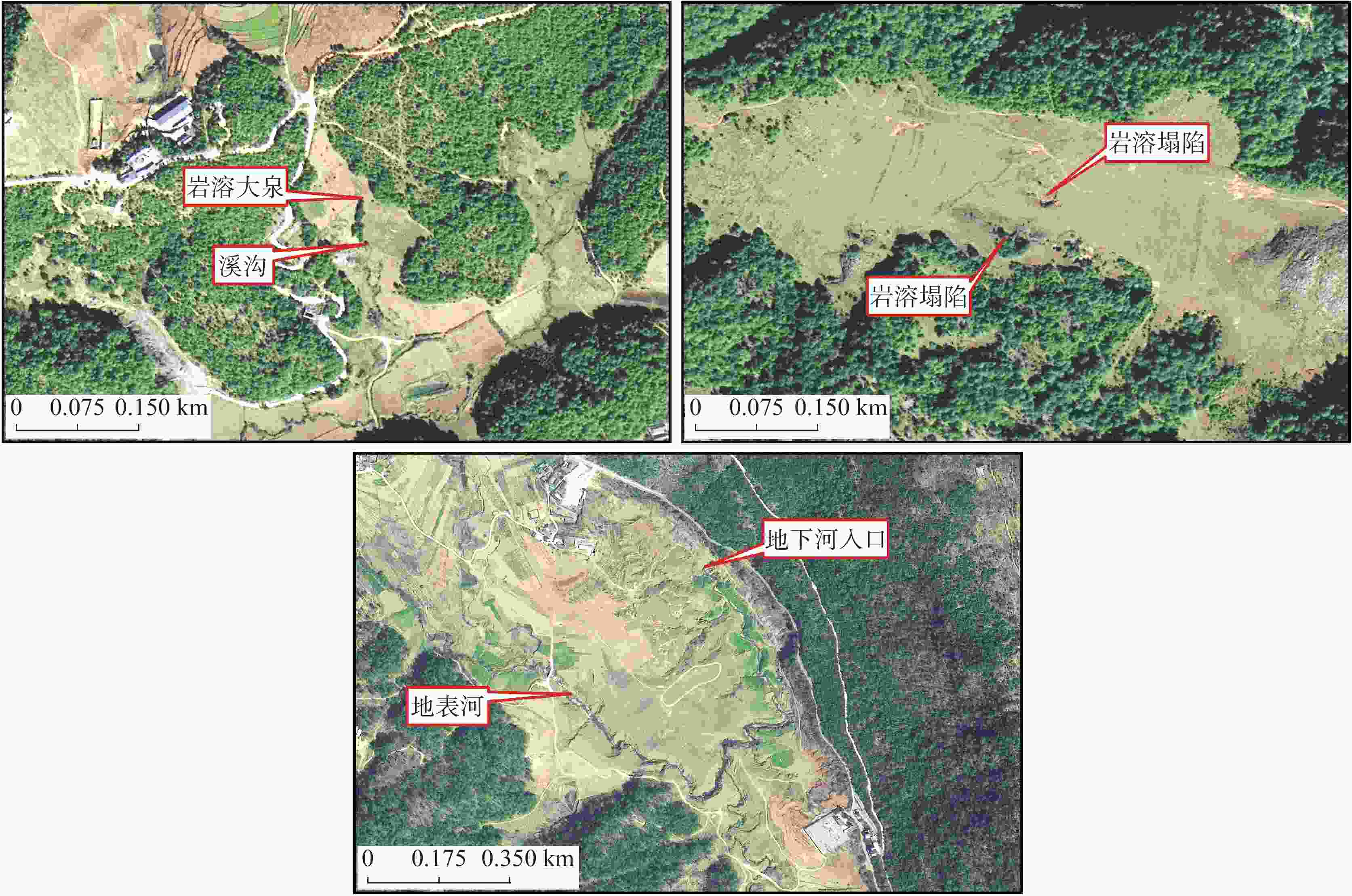
图 4 华坪县典型水文地质遥感影像图
Figure 4. Remote sensing images of typical hydrogeology in Huaping county
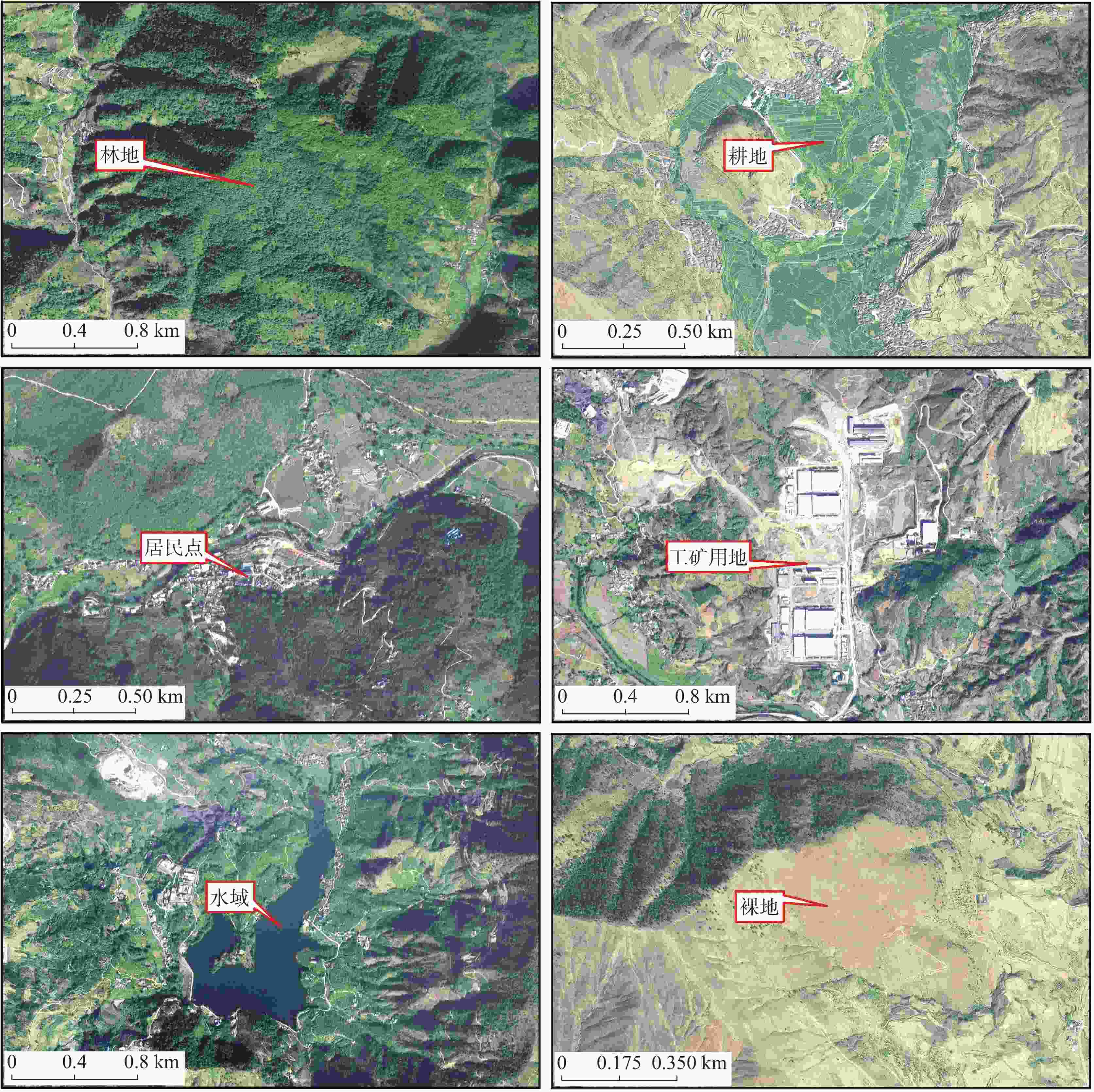
图 5 华坪县典型土地利用遥感影像图
Figure 5. Remote sensing images of typical land use in Huaping county
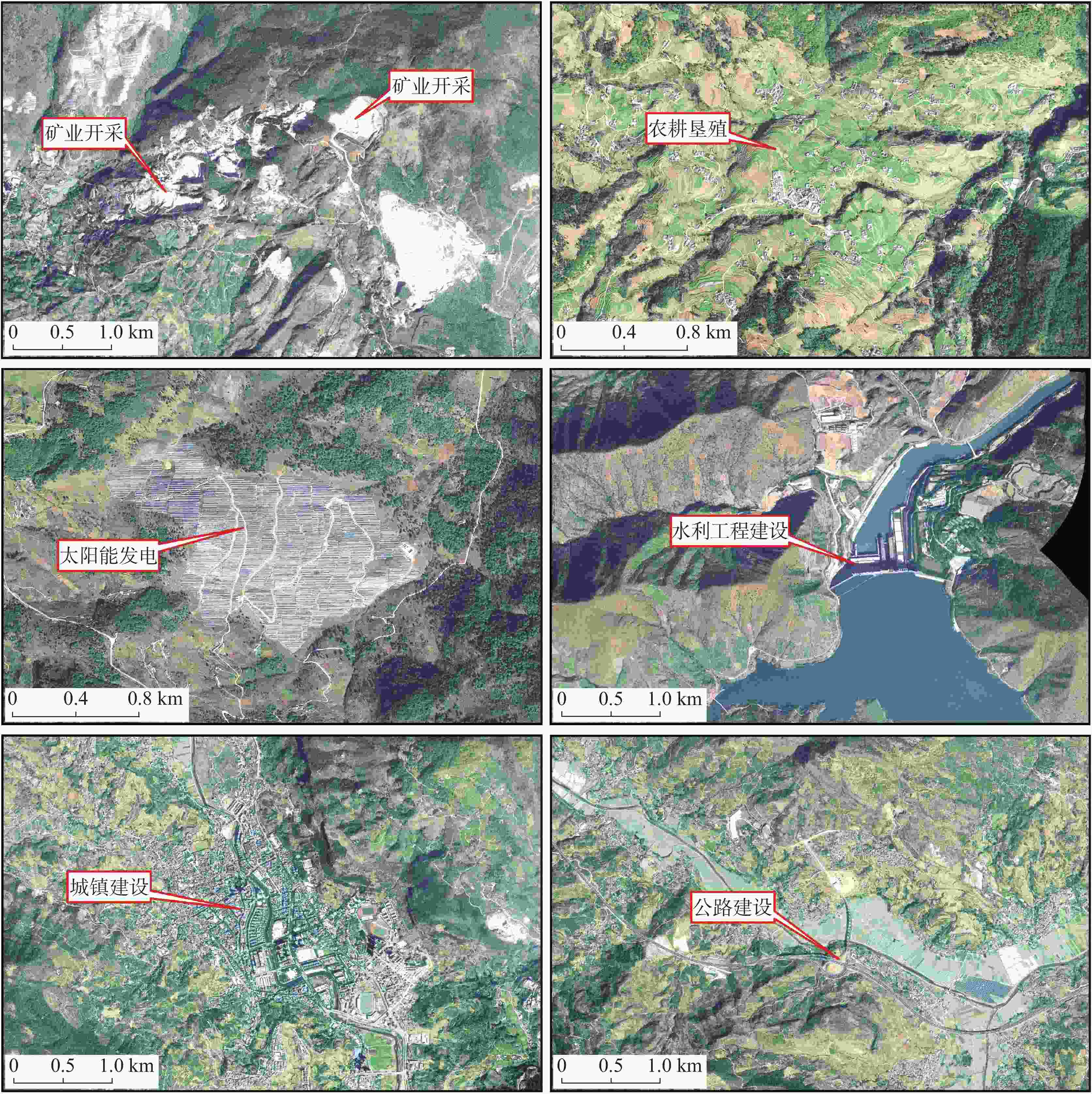
图 6 华坪县典型人类活动遥感影像图
Figure 6. Remote sensing images of typical human activities in Huaping county
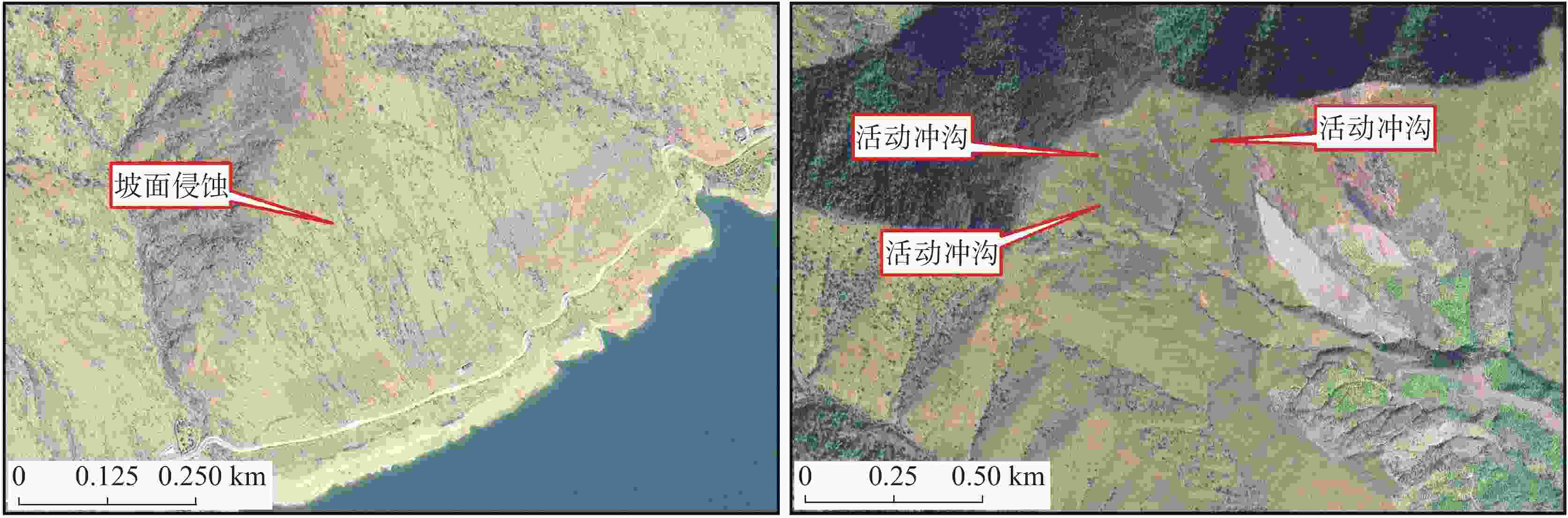
图 7 华坪县典型不良地质现象遥感影像图
Figure 7. Remote sensing images of typical adverse geological phenomena in Huaping county
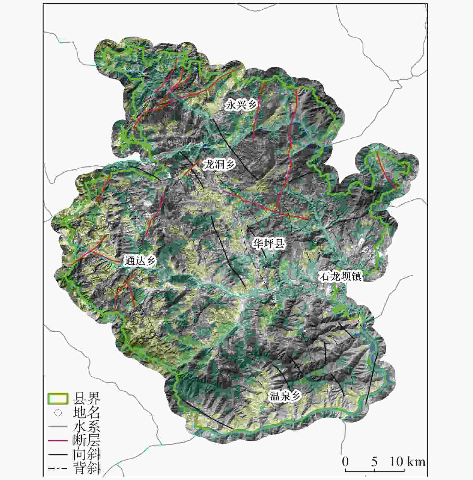
图 8 华坪县地质环境解译遥感解译成果(地质构造)
Figure 8. Remote sensing results of geological environment interpretation of geological structures in Huaping county
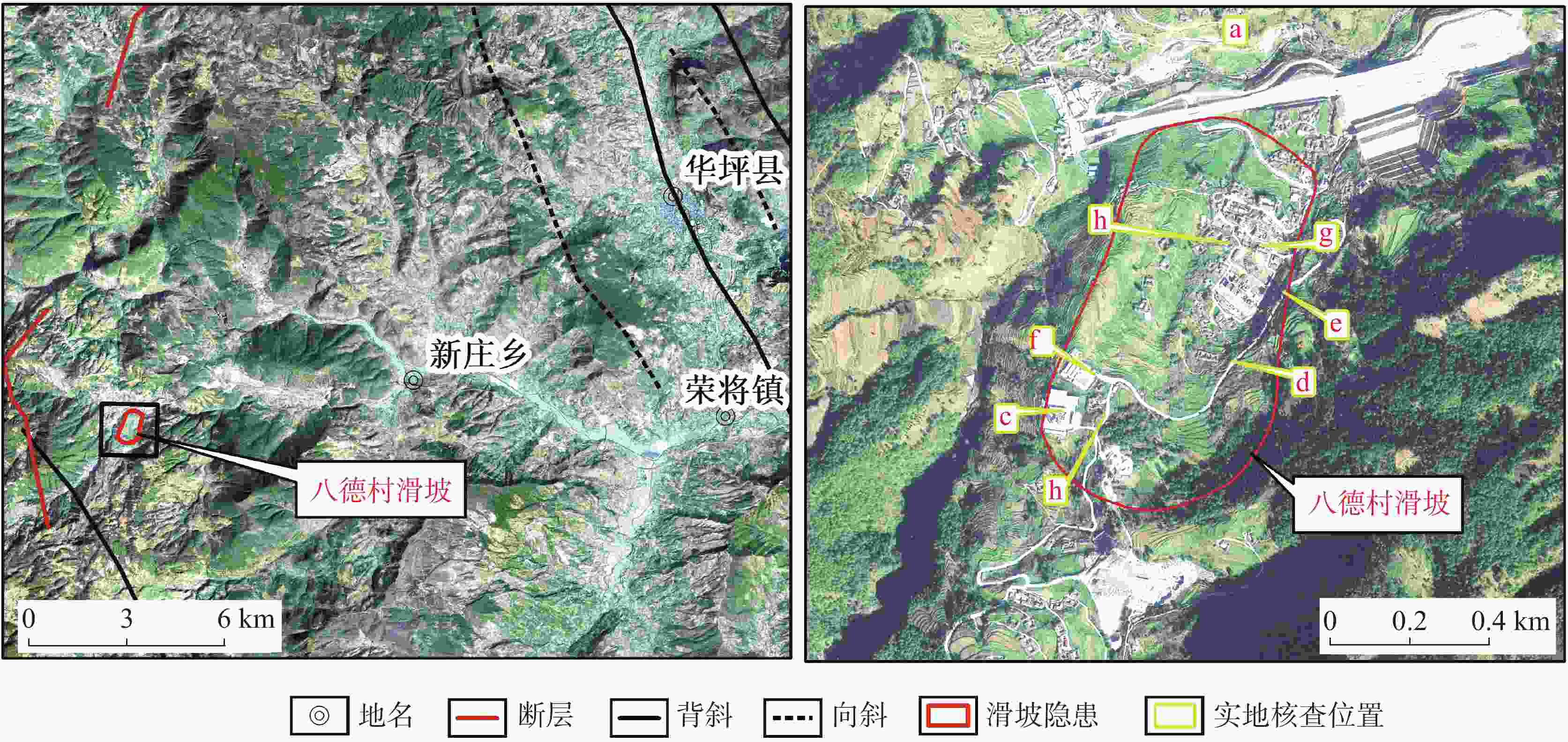
图 9 八德村滑坡隐患光学遥感影像
Figure 9. Optical remote sensing images of potential landslides in Bade village
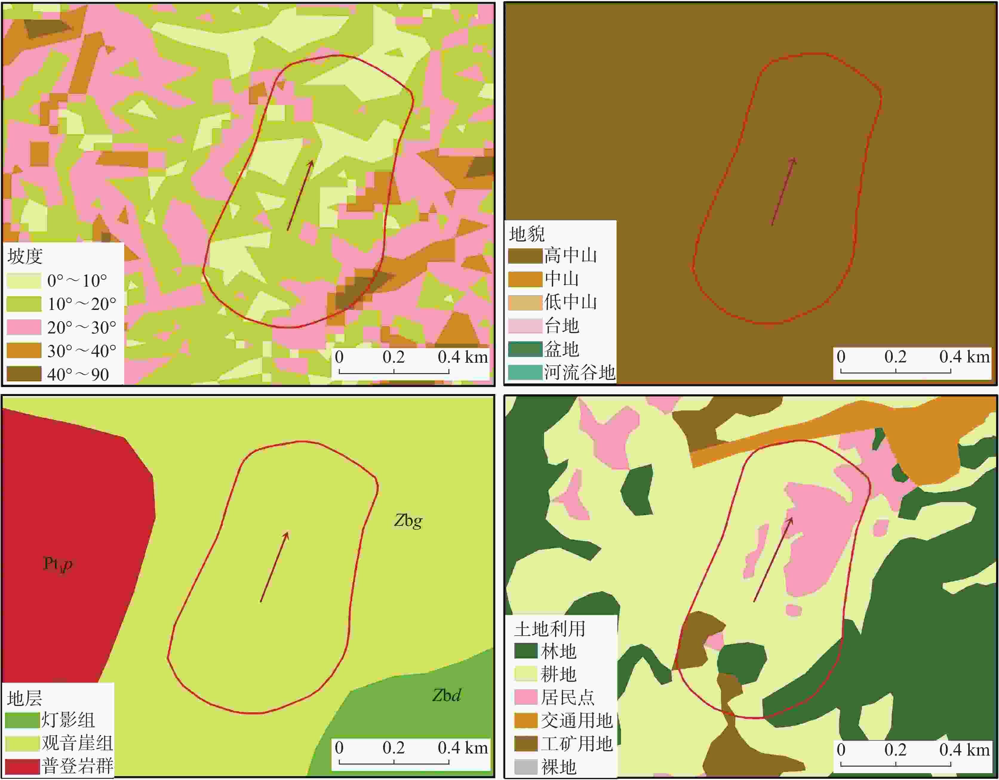
图 10 八德村滑坡隐患地质环境遥感解译
Figure 10. Remote sensing interpretation of geological environment of potential landslides in Bade Village
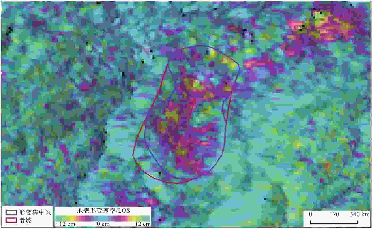
图 11 八德村滑坡隐患地表形变速率图
Figure 11. Surface deformation rates of potential landslides in Bade village
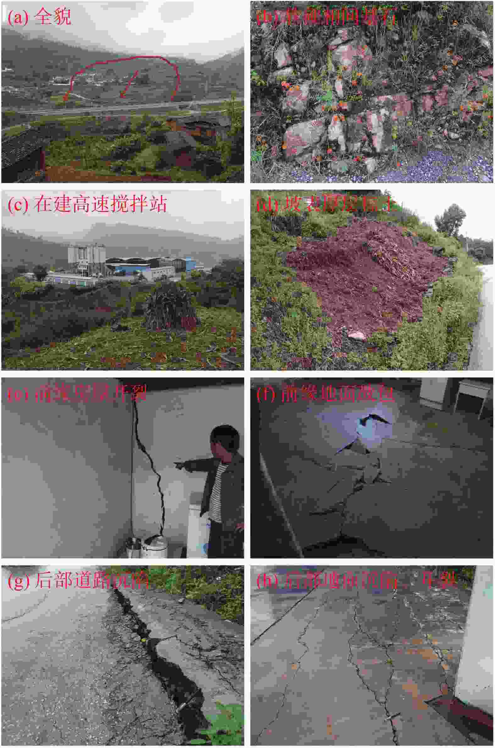
图 12 八德村滑坡隐患实地调查情况
Figure 12. Field investigation of potential landslides in Bade village
表 1 华坪县地质灾害(隐患)情况
Table 1. Situation of geo-hazards (hidden dangers) in Huaping county
灾害类型 特大型 大型 中型 小型 合计 地质灾害类型所占百分比 滑坡 0 7 74 105 186 72.37% 泥石流 0 0 5 30 35 13.62% 崩塌 0 5 14 4 23 8.95% 地面塌陷 0 0 0 13 13 5.06% 合计 0 12 93 152 257 100.00% 规模所占百分比 0 4.67% 36.19% 59.14% 100.00%  下载: 导出CSV
表 2 北京二号卫星数据主要参数
Table 2. Main parameters of Beijing-2 High-Resolution Optical Remote Sensing Images
卫星 国家 发射时间 全色分辨率 多光谱分辨率 重访周期 幅宽 北京二号 中国 2015.7.11 0.8 m 3.2 m 1~2 d 24 km
下载: 导出CSV
表 3 华坪县县域地质灾害隐患地质环境遥感解译体系
Table 3. Remote sensing interpretation system of geological environment conditions of potential geo-hazards in Huaping county
序号 地质环境解译大类 地质环境遥感解译要素 1 地形地貌 阶地、洼地 2 地质构造 断层、背斜 3 地层岩性 碎屑岩区—侏罗系下统冯家河组(J1f)、碳酸盐岩区—震旦系上统灯影组(Zbd) 4 水文地质 泉点、地下河出入口、岩溶塌陷 5 土地利用 耕地、林地、水域、居民点、工矿用地、裸地 6 人类活动 矿业开采、水电建设、城镇建设、公路建设、农耕垦殖 7 不良地质现象 坡面侵蚀、活动冲沟
下载: 导出CSV
表 4 八德村滑坡隐患地质环境特征
Table 4. Geological environment characteristics of potential landslides in Bade village
序号 地质环境大类 地质环境特征 1 地形地貌 高中山谷地地貌,凹坡,坡向20°,坡度不均,10°~30° 2 地质构造 未见 3 地层岩性 基岩地层为震旦系上统观音崖组(Zbg),产状60°∠20°,上、中部为紫红色、灰白色页岩与灰岩、白云岩互层,下部为灰白色石英砂岩、长石石英砂岩,底部具有砾岩,软硬相间的岩土性质,近顺层坡;岩体节理裂隙发育,表层风化作用强,基岩破碎 4 水文地质 碎屑岩夹碳酸盐岩类含水岩组,含岩溶裂隙水,未见明显地下水迹象 5 土地利用 耕地、林地、居民点、工矿用地,土地利用类型特征明显 6 人类活动 矿业开采、公路建设、农耕垦殖,人类活动强烈 7 不良地质现象 未见
下载: 导出CSV
-
[1] 范一大, 吴玮, 王薇, 刘明, 温奇. 中国灾害遥感研究进展[J]. 遥感学报, 2016, 20(5):1170-1184.FAN Yida, WU Wei, WANG Wei, LIU Ming, WEN Qi. Research progress of disaster remote sensing in China[J]. Journal of Remote Sensing, 2016, 20(5): 1170-1184. [2] 李树德. 中国滑坡、泥石流灾害的时空分布特点[J]. 水土保持研究, 1999, 6(4):33-37.LI Shude. The temporal and spacial distribution of landslide and debris flow disasters in China[J]. Research of Soil and Water Conservation, 1999, 6(4): 33-37. [3] 铁永波, 葛华, 高延超, 白永健, 徐伟, 龚凌枫, 王家柱, 田凯, 熊小辉, 范文录, 张宪政. 二十世纪以来西南地区地质灾害研究历程与展望[J]. 沉积与特提斯地质, 2022, 42(4):653-665.TIE Yongbo, GE Hua, GAO Yanchao, BAI Yongjian, XU Wei, GONG Lingfeng, WANG Jiazhu, TIAN Kai, XIONG Xiaohui, FAN Wenlu, ZHANG Xianzheng. The research progress and prospect of geological hazards in Southwest China since the 20th century[J]. Sedimentary Geology and Tethyan Geology, 2022, 42(4): 653-665. [4] 葛大庆, 戴可人, 郭兆成, 李振洪. 重大地质灾害隐患早期识别中综合遥感应用的思考与建议[J]. 武汉大学学报(信息科学版), 2019, 44(7):949-956.GE Daqing, DAI Keren, GUO Zhaocheng, LI Zhenhong. Early identification of serious geological hazards with integrated remote sensing technologies: Thoughts and recommendations[J]. Geomatics and Information Science of Wuhan University, 2019, 44(7): 949-956. [5] Xie M W, Huang J X, Wang L W, Huang J H, Wang Z F. Early landslide detection based on D-InSAR technique at the Wudongde hydropower reservoir[J]. Environmental Earth Sciences, 2016, 75(8): 1-13. [6] Sun Q, Zhang L, Ding X, Hu J, Li Z W, Zhu J J. Slope deformation prior to Zhouqu, China landslide from InSAR time series analysis[J]. Remote Sensing of Environment, 2015, 156: 45-57. doi: 10.1016/j.rse.2014.09.029 [7] 王绚, 范宣梅, 杨帆, 董秀军. 植被茂密山区地质灾害遥感解译方法研究[J]. 武汉大学学报(信息科学版), 2020, 45(11):1771-1781.WANG Xuan, FAN Xuanmei, YANG Fan, DONG Xiujun. Remote sensing interpretation method of geological hazards in lush mountainous area[J]. Geomatics and Information Science of Wuhan University, 2020, 45(11): 1771-1781. [8] 闫茂华, 魏云杰, 李亚民, 刘明学, 王文沛, 王俊豪, 曹峰. 云南德钦日因卡滑坡孕灾背景及形成机理[J]. 地质通报, 2020, 39(12):1971-1980. doi: 10.12097/j.issn.1671-2552.2020.12.011YAN Maohua, WEI Yunjie, LI Yamin, LIU Mingxue, WANG Wenpei, WANG Junhao, CAO Feng. Development characteristics and formation mechanism of Deqin Riyinka landslide in Yunnan[J]. Geological Bulletin of China, 2020, 39(12): 1971-1980. doi: 10.12097/j.issn.1671-2552.2020.12.011 [9] 李滨, 殷跃平, 高杨, 邢爱国, 黄波林, 贺凯, 赵超英, 万佳威. 西南岩溶山区大型崩滑灾害研究的关键问题[J]. 水文地质工程地质, 2020, 47(4):5-13.LI Bin, YIN Yueping, GAO Yang, XING Aiguo, HUANG Bolin, HE Kai, ZHAO Chaoying, WAN Jiawei. Critical issues in rock avalanches in the karst mountain areas of Southwest China[J]. Hydrogeology & Engineering Geology, 2020, 47(4): 5-13. [10] 许强. 构建新“三查”体系 创建地灾防治新机制[OL]. 北京:中国矿业报, 2018(2018-3-12). https://www.51ore.com/kyxw/17220.html. [11] 许强. 对地质灾害隐患早期识别相关问题的认识与思考[J]. 武汉大学学报(信息科学版), 2020, 45(11):1651-1659.XU Qiang. Understanding and consideration of related issues in early identification of potential geohazards[J]. Geomatics and Information Science of Wuhan University, 2020, 45(11): 1651-1659. [12] 湖南省地质环境监测总站. 地质灾害遥感调查技术规定:DD2015-01[S]. 北京:中国地质调查局, 2015. [13] 安徽省地质调查院. 区域地质调查中遥感技术规定(1∶50 000):DZ/T 0151-2015[S]. 北京:中华人民共和国国土资源部, 2015.Geological Survey of Anhui Province. Specification of remote sensing technique in regional geological survey (1: 50,000): DZ/T 0151-2015[S]. Beijing: Ministry of Land and Resources of the People's Republic of China, 2015. [14] 中国国土资源航空物探遥感中心. 区域环境地质勘查遥感技术规定(1∶50 000):DZ/T 0190-2015[S]. 北京:中华人民共和国国土资源部, 2015.China Aero Geophysical Survey and Remote Sensing Center for Natural Resources. Specification of remote sensing technology for regional environment geological exploration (1∶50,000): DZ/T 0190-2015[S]. Beijing: Ministry of Land and Resources of the People's Republic of China, 2015. [15] 中国地质环境监测院. 地质灾害危险性评估规范:GB/T 40112-2021[S]. 北京:中华人民共和国自然资源部, 2021.China Institute of Geo-Environment Monitoring. Specifications for risk assessment of geological hazard: GB/T 40112-2021[S]. Beijing: Ministry of Natural Resources of the People's Republic of China, 2021. [16] Rosi A, Tofani V, Tanteri L, Tacconi Stefanelli C, Agostini A, Catani F, Casagli N. The new landslide inventory of Tuscany (Italy) updated with PS-InSAR: Geomorphological features and landslide distribution[J]. Landslides, 2018, 15(1): 5-19. doi: 10.1007/s10346-017-0861-4 [17] Dong J, Liao M S, Xu Q, Zhang L, Tang M G, Gong J Y. Detection and displacement characterization of landslides using multitemporal satellite SAR interferometry: A case study of Danba county in the Dadu river basin[J]. Engineering Geology, 2018, 240: 95-109. doi: 10.1016/j.enggeo.2018.04.015 [18] 陈立权, 赵超英, 任超锋, 王佩杰, 陈雪蓉, 陈恒祎. 光学遥感用于贵州发耳镇尖山营滑坡监测研究[J]. 中国岩溶, 2020, 39(4):518-523.CHEN Liquan, ZHAO Chaoying, REN Chaofeng, WANG Peijie, CHEN Xuerong, CHEN Hengyi. Monitoring the Jianshanying landslide in a karst mountainous area of Guizhou by optical remote sensing[J]. Carsologica Sinica, 2020, 39(4): 518-523. [19] 付豪, 李为乐, 陆会燕, 许强, 董秀军, 郭晨, 谢毅, 王栋, 刘刚, 马志刚. 基于“三查”体系的丹巴县滑坡隐患早期识别与监测[J]. 武汉大学学报(信息科学版), 2024, 49(5):734-746.FU Hao, LI Weile, LU Huiyan, XU Qiang, DONG Xiujun, GUO Chen, XIE Yi, WANG Dong, LIU Gang, MA Zhigang. Early detection and monitoring of potential landslides in Danba county based on the space-air-ground investigation system[J]. Geomatics and Information Science of Wuhan University, 2024, 49(5): 734-746. [20] 贺凯, 李滨, 赵超英, 高杨, 陈立权, 刘朋飞. 基于易滑地质结构与多源数据差异的岩溶山区大型崩滑灾害识别研究[J]. 中国岩溶, 2020, 39(4):467-477.HE Kai, LI Bin, ZHAO Chaoying, GAO Yang, CHEN Liquan, LIU Pengfei. Identification of large-scale landslide hazards based on differences of geological structure prone to sliding and multiple-source data in karst mountainous areas[J]. Carsologica Sinica, 2020, 39(4): 467-477. [21] 董佳慧, 牛瑞卿, 亓梦茹, 丁赞, 徐航, 何睿. InSAR技术和孕灾背景指标相结合的地灾隐患识别[J]. 地质科技通报, 2022, 41(2):187-196.DONG Jiahui, NIU Ruiqin, QI Mengru, DING Zan, XU Hang, HE Rui. Identification of geological hazards based on the combination of InSAR technology and disaster background indicators[J]. Bulletin of Geological Science and Technology, 2022, 41(2): 187-196. [22] 许强, 董秀军, 李为乐. 基于天—空—地一体化的重大地质灾害隐患早期识别与监测预警[J]. 武汉大学学报(信息科学版), 2019, 44(7):957-966.XU Qiang, DONG Xiujun, LI Weile. Integrated space-air-ground early detection, monitoring and warning system for potential catastrophic geohazards[J]. Geomatics and Information Science of Wuhan University, 2019, 44(7): 957-966. [23] 刘传正. 论地质灾害风险识别问题[J]. 水文地质工程地质, 2017, 44(4):1-7.LIU Chuanzheng. Research on the risk recognition of geological disasters[J]. Hydrogeology & Engineering Geology, 2017, 44(4): 1-7. [24] 刘传正, 张明霞, 刘艳辉. 区域地质环境可持续利用评价体系初步研究[J]. 地学前缘, 2006, 13(1):242-245. doi: 10.3321/j.issn:1005-2321.2006.01.033LIU Chuanzheng, ZHANG Mingxia, LIU Yanhui. A system of geo-environment evaluation based on sustainable land-use[J]. Earth Science Frontiers, 2006, 13(1): 242-245. doi: 10.3321/j.issn:1005-2321.2006.01.033 [25] 孟晖, 张若琳, 石菊松, 李春燕. 地质环境安全评价[J]. 地球科学, 2021, 46(10):3764-3776.MENG Hui, ZHANG Ruolin, SHI Jusong, LI Chunyan. Geological environment safety evaluation[J]. Earth Science, 2021, 46(10): 3764-3776. [26] 云南华昆国电工程勘察有限公司. 云南省华坪县地质灾害详细调查报告[R]. 2014: 50-98. [27] 黄润秋. 20世纪以来中国的大型滑坡及其发生机制[J]. 岩石力学与工程学报, 2007, 26(3):433-454. doi: 10.3321/j.issn:1000-6915.2007.03.001HUANG Runqiu. Large-scale landslides and their sliding mechanisms in China since the 20th century[J]. Chinese Journal of Rock Mechanics and Engineering, 2007, 26(3): 433-454. doi: 10.3321/j.issn:1000-6915.2007.03.001 [28] 刘传正, 陈春利. 中国地质灾害成因分析[J]. 地质论评, 2020, 66(5):1334-1348.LIU Chuanzheng, CHEN Chunli. Research on the origins of geological disasters in China[J]. Geological Review, 2020, 66(5): 1334-1348. [29] 张丽君. 从土地利用规划入手提高地质灾害的防治水平:兼议地质灾害风险区划的急迫性与重要性[J]. 地质通报, 2009, 28(2-3):343-347.ZHANG Lijun. Prevention of geological hazard starting from land use planning[J]. Geological Bulletin of China, 2009, 28(2-3): 343-347. [30] 刘传正. 中国崩塌滑坡泥石流灾害成因类型[J]. 地质论评, 2014, 60(4):858-868.LIU Chuanzheng. Genetic types of landslide and debris flow disasters in China[J]. Geological Review, 2014, 60(4): 858-868. [31] 蒋小珍, 冯涛, 郑志文, 雷明堂, 张伟, 马骁, 伊小娟. 岩溶塌陷机理研究进展[J]. 中国岩溶, 2023, 42(3):517-527.JIANG Xiaozhen, FENG Tao, ZHENG Zhiwen, LEI Mingtang, ZHANG Wei, MA Xiao, YI Xiaojuan. A review of karst collapse mechanisms[J]. Carsologica Sinica, 2023, 42(3): 517-527. [32] 中国地质环境监测院. 地质灾害风险调查评价技术要求(1∶50 000)(试行)[S]. 北京:中华人民共和国自然资源部, 2020. -


 点击查看大图
计量
- 文章访问数: 425
- HTML浏览量: 265
- PDF下载量: 51
- 被引次数: 0
