Experiment of monitoring multi-layer groundwater at a karst hill slope and its scientific significance
-
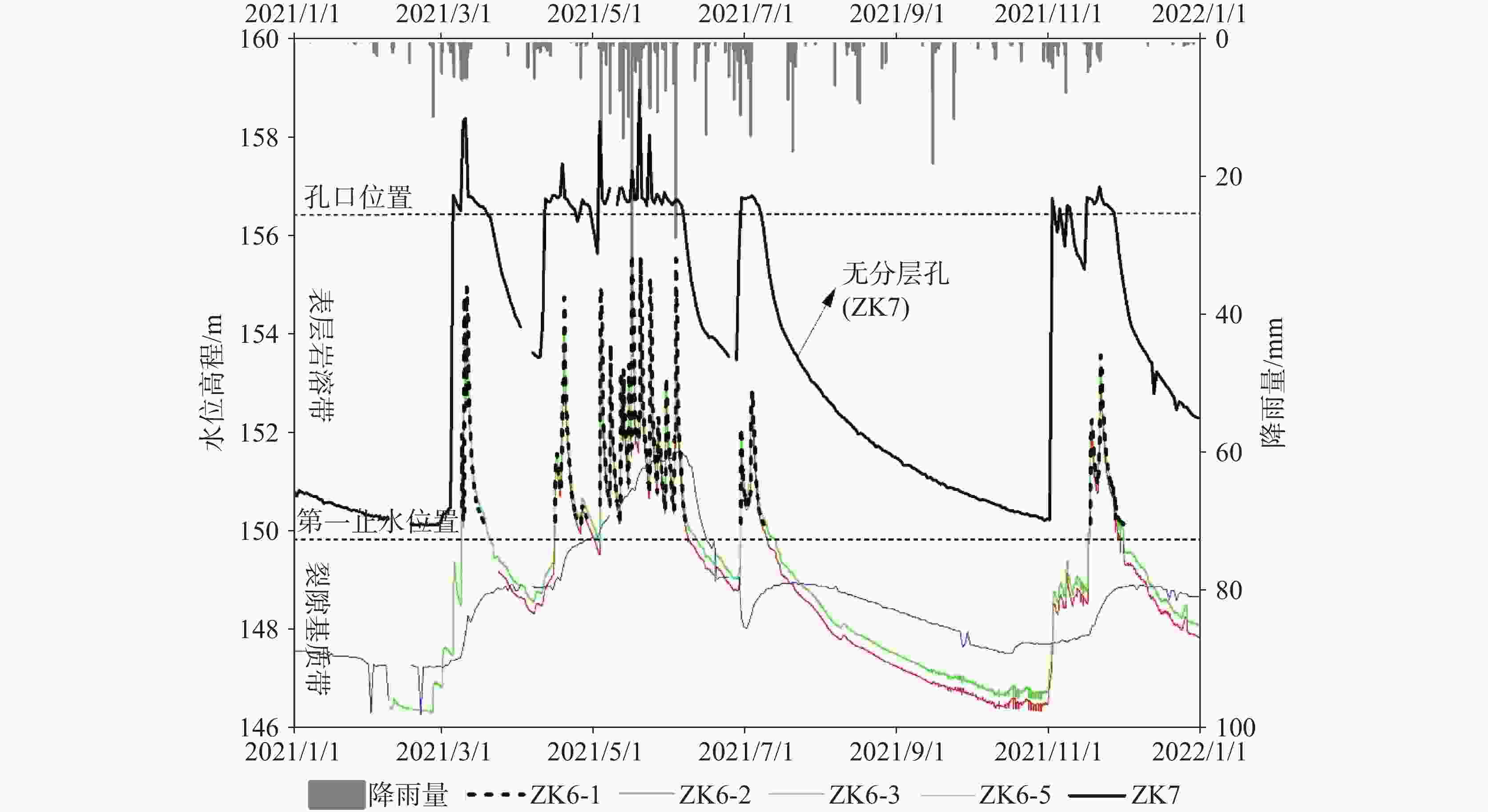
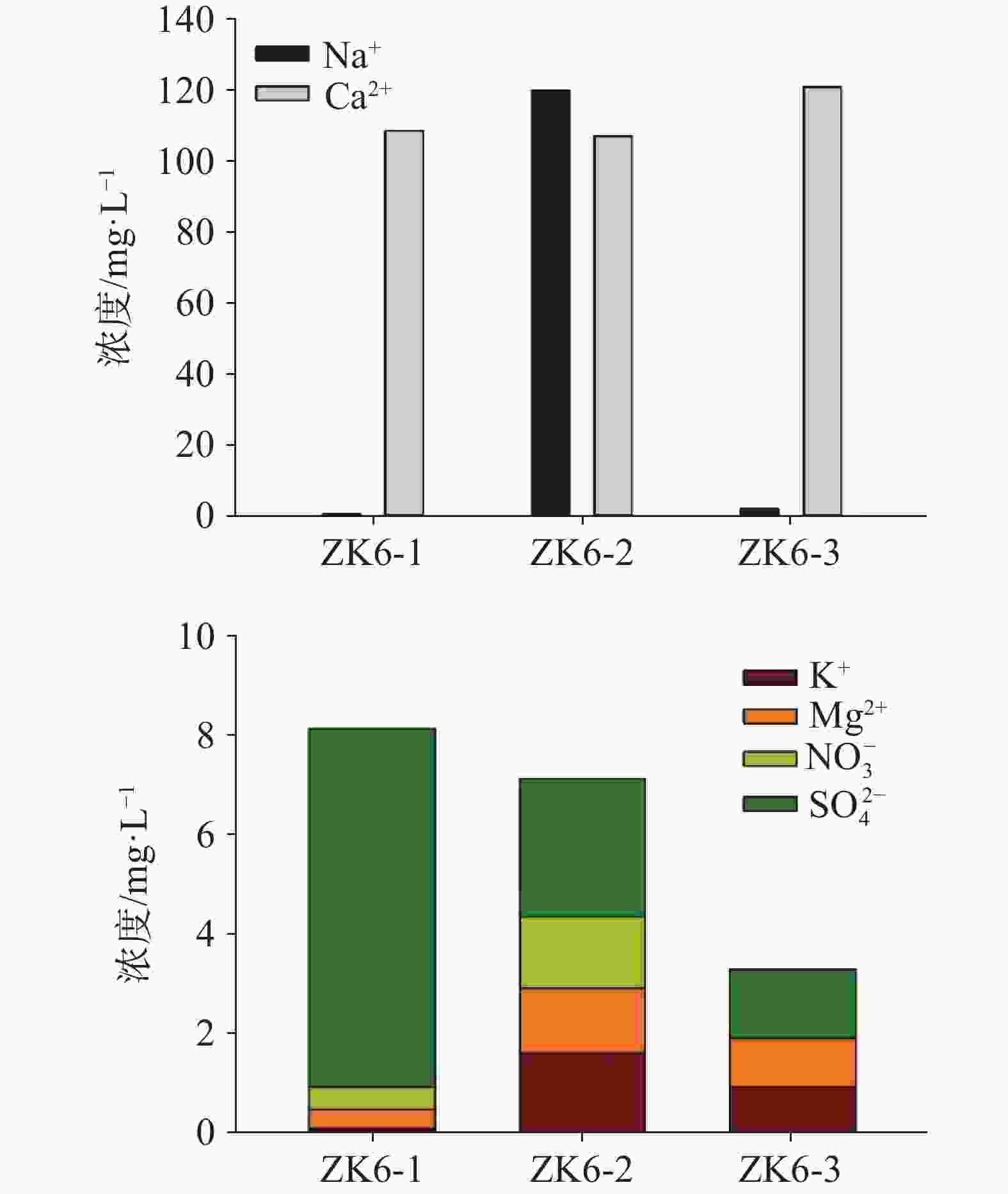
摘要: 钻孔是揭露含水层结构和开展地下水监测的重要载体。在场地地下水监测中,不分层的丛式钻孔存在成本高、代表性不全等缺陷。“一孔多层”分层监测对水头或溶质分布的区分度高,在孔隙和裂隙含水层应用广泛,但岩溶介质因结构复杂,极少有案例研究。文章对丫吉试验场西坡径流小区的一个钻孔(ZK6)进行分层并开展监测。依据钻孔岩芯编录资料、抽水试验以及水化学与温度测孔的结果,判断岩溶发育的特征,确定将ZK6孔划分为四层,实施了钻孔封隔。对四个层位的水文观测发现,四个层位的水位动态对降雨的响应有较大差异。其中,第一层一个水文年中无水和充水状态时长分别占79%和21%,说明该层的岩溶介质处于充水和无水交替,且更多时间处于无水状态;第二层水位响应滞后明显;第三层和第四层水头差异表现出地下水排泄区的水头垂直分布特征。ZK6孔四个层位的水化学存在差异,表明岩溶介质结构的差异不仅影响了水文过程也影响水化学特征。第四层的电导率基本稳定在450 μS·cm−1,而第二层因表层元素积累和水更新速率慢,电导率是第四层的2倍,第一层电导率的剧烈变化则反映表层岩溶带受到降雨补给影响最为强烈。综合钻孔分层的水文和水化学特征,认为第一至第四层分别代表表层岩溶带、裂隙基质带、上部饱水带和下部饱水带。岩溶山坡的“一孔多层”分层技术难度大,但一旦实现不仅可以认识岩溶垂向分带的水动力机制,也为地下水分层开发利用技术突破提供了可能。Abstract:
The heterogeneity of karst aquifers and the complexity of karst hydrogeological conditions pose significant challenges to groundwater observation compared to the groundwater in pore and fissure aquifers. In the areas of springs or underground rivers in which lack natural groundwater outcrops, borehole drilling is crucial for us to reveal aquifer structures and monitor groundwater. Clustered single-hole drilling inadequacies are pronounced in karst regions, because we need numerous times of single-hole drillings to comprehensively reveal different aquifer conditions, which may in turn result in land occupation and high costs. Besides, the difficulty in accurately locating karst conduits or fractures, due to complex hydrogeological conditions, may contribute to potential incompleteness of single-hole representativeness. Finally, drilling for groundwater monitoring may traverse multiple geological layers, causing interconnection of groundwater, thereby making it impossible for us to distinguish water quality conditions in different layers or channels during groundwater quality monitoring. The drilling of one shaft with multi-layer borehole refers to the technique that can achieve segmentation of multiple layers within a single borehole drilling operation. This technique, also known as Continuous Multichannel Tubing (CMT), is an internationally recognized method for layered drilling monitoring, is widely utilized in North America but seldom used in China. Because the technique of one shaft with multi-layer monitoring demonstrates its high ability in differentiating water head or solute distribution, it has been extensively applied in monitoring in pore and fissure aquifers, but seldom in karst media because of its complex structure. Therefore, there are no reported cases of application of this technique in karst regions, and its feasibility needs to be confirmed. The Yaji karst hydrogeological experimental site (hereinafter referred to the Yaji experimental site) represents a typical bared karst aquifer system in Southern China. The aquifer comprises three parts: the upper vadose zone, lower vadose zone, and saturated zone, playing the role of rainfall storage and regulation. Eighteen clustered-distributed boreholes established at the experimental site can reflect the heterogeneity of karst development or water level changes on a planar scale, yet they can hardly reveal the vertical groundwater movement. It is difficult for us to use open boreholes in defining how the differences in karst development vertically affect hydrodynamics. Therefore, this study selected one borehole (ZK6) from the runoff area on the western slope of the Yaji experimental site to implement the one shaft with multi-layer drilling experiment, aiming to explore the application of layered drilling monitoring technique in karst aquifers. The study result can provide conditions for understanding groundwater stratification, vertical distribution of water heads, and layered pumping, and more importantly, provide experience in applying borehole layering techniques and schemes in highly heterogeneous karst water-bearing media. Firstly, based on the data of borehole core, pumping tests, and results from hydrochemical and temperature logging, ZK6 was divided into four layers, with karst development characteristics as the main basis for division. Secondly, hydrological and hydrochemical characteristics of the four layers were compared and analyzed. Significant differences were found in the water level dynamics of the four layers in response to rainfall. The first layer predominantly alternates between being dry and being filled with water throughout a hydrological year, occupying 79% and 21% of the time respectively, which indicates alternating dry and wet conditions in the karst media, with a tendency towards dryness. The second layer exhibits significant lags in water level response. Differences in water heads between the third and fourth layers reflect the vertical distribution characteristics of groundwater discharge zones. Differences in hydrochemical characteristics among the four layers suggest that discrepancies in karst media structures affect both hydrological processes and hydrochemical characteristics. The electrical conductivity in the fourth layer remains relatively stable at 450 μS·cm−1, while in the second layer, due to surface element accumulation and slow water renewal rates, the electrical conductivity is twice that of the fourth layer. The drastic changes in electrical conductivity in the first layer reflect the strong influence of rainfall recharge in the surface karst zone. Finally, based on the hydrological and hydrochemical characteristics of borehole layers, it is concluded that the first to fourth layers respectively represent the epikarst zone, fissure-matrix zone, upper saturated zone and lower saturated zone. Although the technique of one shaft with multi-layer poses operating challenges in karst mountain slopes, once achieved, it will not only facilitate our understanding of the vertical hydrodynamic mechanisms of karst stratification, but will also achieve possible breakthroughs in technology for layering development and utilization of groundwater in heterogeneous karst aquifers. The use of borehole layering monitoring technique enables the measurement of vertical distribution of water heads within boreholes, thereby providing the potential for utilizing layering isolation techniques to facilitate runoff utilization from epikarst zones and vadose zones. -
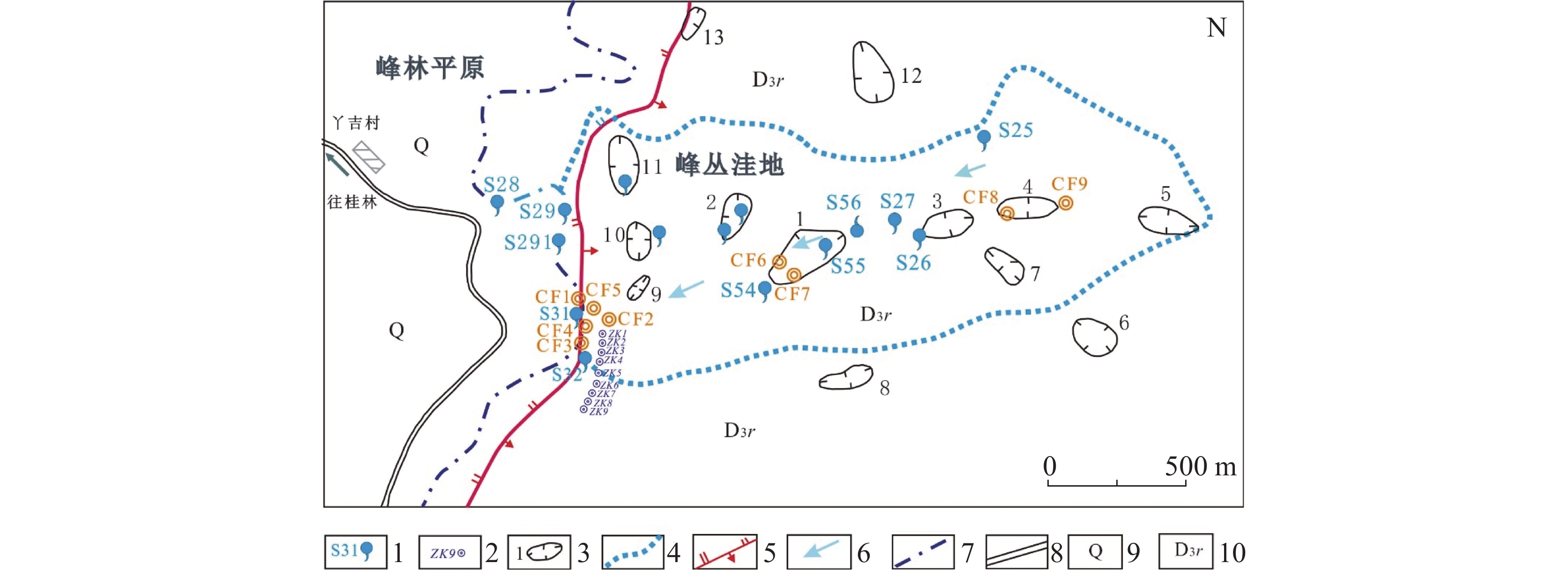
图 1 丫吉试验场S31泉域系统与钻孔分布图
1. 泉水及编号 2. 钻孔及编号 3. 洼地及编号 4. 系统边界 5. 断层 6. 地下水流向 7.峰丛洼地与峰林平原界线 8. 公路 9. 第四系 10.融县组灰岩
Figure 1. S31 spring system and borehole distribution in the Yaji experimental site
1. Springs and numbers 2. Boreholes and numbers 3. Karst depressions and numbers 4. Water system boundary 5. Fault 6. Groundwater flow direction 7. Boundary of peak cluster-depression and peak forest-plain 8. Road 9. Quaternary 10. Limestone in Rongxian Formation
表 1 钻孔ZK6的分层方案
Table 1. Layering scheme of borehole ZK6
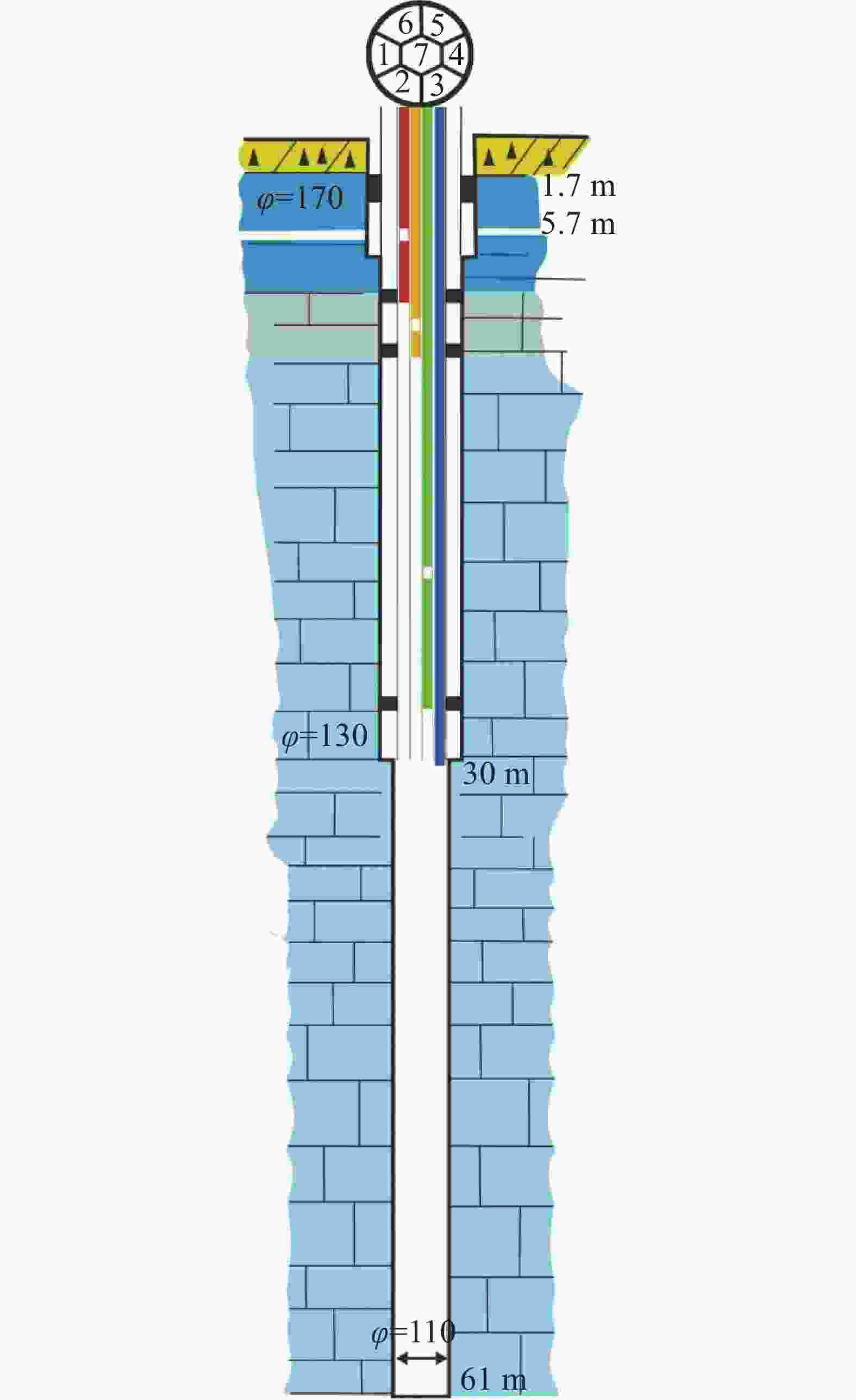
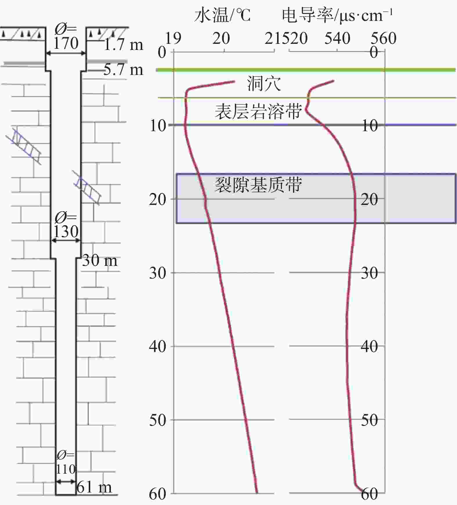
层位 通道 分层位置 岩溶特征 分层目标 第一层 ZK6-1 岩石表面至洞穴下方。深度为地面以下6.5 m(156.45~149.95 m) 发育0.7 m高的洞穴 洞穴可能为表层岩溶水季节性的排泄通道,需要独立观测水位 第二层 ZK6-2 第一止水位置(6.5 m)至表层岩溶带的下界,第二止水位置为地面以下10 m(149.95~146.45 m) 疑似岩溶管道一处 水化学与温度变化趋势发生变化,需要独立观测 第三层 ZK6-3 第二止水位置至变径处,止水位置为地面以下28 m(146.45~128.45 m) 岩溶裂隙发育的
迹象岩溶裂隙水流导致水化学变化,推测可能是坡面下部径流的主要排泄区 第四层 ZK6-4、ZK6-5
ZK6-6、ZK6-7第三止水位置以下至孔底(128.45~95.45 m) 具有弱岩溶现象的
裂隙水流微弱,可能是地下缓流层 表 2 ZK6分层之前与其他坡面钻孔的水的物理-化学性质对比
Table 2. Comparison of physicochemical properties of ZK6 before layering and other boreholes at the slopes
钻孔编号 水深
/mCa2+ ${\rm{HCO}}_3^{-}$ 温度
/℃pH 电导率
/μS·cm−1/mg·L−1 ZK1 9.63 138 378 26.6 7.13 580 ZK2 8.84 137 317 27.3 7.38 456 ZK3 7.91 98 268 24.4 7.57 409 ZK4 2.72 108 329 25.1 7.30 498 ZK5 7.57 130 397 27.8 7.20 531 ZK6 6.50 136 397 21.1 7.15 590 ZK7 6.19 82 238 20.3 7.58 391 ZK8 4.57 131 354 20.5 7.25 549 ZK9 3.65 148 433 25.3 7.10 665 -
[1] 张贵, 何绕生, 张华, 王波, 张文鋆, 彭淑惠, 俞富有, 彭勇. 云南泸西盆地边缘既比岩溶水勘查及应急抗旱示范工程[J]. 中国岩溶, 2021, 40(4):654-660.ZHANG Gui, HE Raosheng, ZHANG Hua, WANG Bo, ZHANG Wenjun, PENG Shuhui, YU Fuyou, PENG Yong. Karst water prospecting and emergency drought relief demonstration project in Jibi area on the edge of Luxi basin, Yunnan Province[J]. Carsologica Sinica, 2021, 40(4): 654-660. [2] Quinn P M, Cherry J A, Parker B L. Quantification of non-Darcian flow observed during parker testing in fractured rock[J]. Water Resources Research, 2011, 47(9): 1-15. [3] 叶成明, 邢卫国, 冯志仁. 新型地下水监测井:多级完整监测井[C]//中国地质调查局. 严重缺水地区地下水勘查论文集. 北京:地质出版社, 2004 [4] 卢予北. 国家级一孔多层地下水示范监测井钻探技术与研究[J]. 探矿工程(岩土钻掘工程), 2007(3):5-8LU Yubei. Drilling technique and study for national grade one shaft with multi-layer underground water demonstration monitoring well[J]. Exploration Engineering (Rock and Soil Drilling and Engineering), 2007(3): 5-8. [5] 袁道先, 戴爱德, 蔡五田, 刘再华, 何师意. 中国南方裸露型岩溶峰丛山区岩溶水系统及其数学模型的研究[M]. 桂林:广西师范大学出版社, 1996. [6] 姜光辉, 陈坤琨, 于奭, 彭稳. 峰丛洼地的坡地径流成分划分[J]. 水文, 2009, 29(6):14-19.JIANG Guanghui, CHEN Kunkun, YU Shi, PENG Wen. Separating karst slope runoff in peak cluster area[J], Journal of China Hydrology, 2009, 29(6): 14-19. [7] 姜光辉, 郭芳. 我国西南岩溶区表层岩溶带的水文动态分析[J]. 水文地质工程地质, 2009, 36(5):89-93. doi: 10.3969/j.issn.1000-3665.2009.05.020JIANG Guanghui, GUO Fang. Hydrological character of epikarst in Southwest China[J]. Hydrogeology and Engineering Geology, 2009, 36(5): 89-93. doi: 10.3969/j.issn.1000-3665.2009.05.020 [8] 刘再华, Chris Groves, 袁道先, Joe Meiman, 姜光辉, 何师意. 水−岩−气相互作用引起的水化学动态变化研究:以桂林岩溶试验场为例[J]. 水文地质工程地质, 2003, 30(4):13-18.LIU Zaihua, Chris Groves, YUAN Daoxian, Joe Meiman, JIANG Guanghui, HE Shiyi. Study on the hydrochemical variations caused by the water–rock–gas interaction: An example from the Guilin karst experimental site[J]. Hydrogeology and Engineering Geology, 2003, 30(4): 13-18. [9] 刘绍华, 汤庆佳, 杨利超, 章程, 苗迎. 岩溶介质非均质性对钻孔水物化指标垂向变化的影响[J]. 中国岩溶, 2015, 34(6):577-585. doi: 10.11932/karst20150606LIU Shaohua, TANG Qingjia, YANG Lichao, ZHANG Cheng, MIAO Ying. Effects of heterogeneity of karst media on the hydrochemical parameters from vertical borehole logs[J]. Carsologica Sinica, 2015, 34(6): 577-585. doi: 10.11932/karst20150606 [10] 姜光辉, 郭芳, 于奭. 岩溶水系统的水化学曲线及其在水文地质研究中的应用[J]. 吉林大学学报(地球科学版), 2015, 45(3):899-907.JIANG Guanghui, GUO Fang, YU Shi. Chemographs of karst water system and its new application in hydrogeological survey[J]. Journal of Jilin University: Earth Science Edition, 2015, 45(3): 899-907. [11] 王建增, 郑继天, 李小杰, 解伟. 连续多通道管监测井成井技术[J]. 探矿工程(岩土钻掘工程), 2008(8):15-18.WANG Jianzeng, ZHENG Jitian, LI Xiaojie, XIE Wei. Well completion technology for continuous multi-tunnel monitoring well[J]. Exploration Engineering (Rock and Soil Drilling and Engineering), 2008(8): 15-18. [12] Parker B, Pehme P, Parker B L, Cherry J A. A temperature vector probe for high resolution profiling in fracture rock boreholes[J]. Journal of Hydrology, 2014, 513: 1011-1114 [13] 贾龙, 蒙彦, 潘宗源, 殷仁朝. 钻孔雷达反射成像在岩溶发育场地探测中的应用[J]. 中国岩溶, 2019, 38(1):124-129 doi: 10.11932/karst20190114JIA Long, MENG Yan, PAN Zongyuan, YIN Renchao. Study on application of borehole radar reflection imaging in the detection of karst area[J]. Carsologica Sinica, 2019, 38(1): 124-129. doi: 10.11932/karst20190114 [14] Quinn P, Cherry J A, Parker B L. Combined use of straddle packer testing and FLUTe profiling for hydraulic testing in fractured rock boreholes[J]. Journal of Hydrology, 2015, 524: 439-454. -


 下载:
下载:
