Study on spatial structure characteristics of epikarst zone interpreted by integrated geophysical method: Taking the slope runoff field of Guohua town ecological experiment base in Pingguo City, Guangxi as an example
-
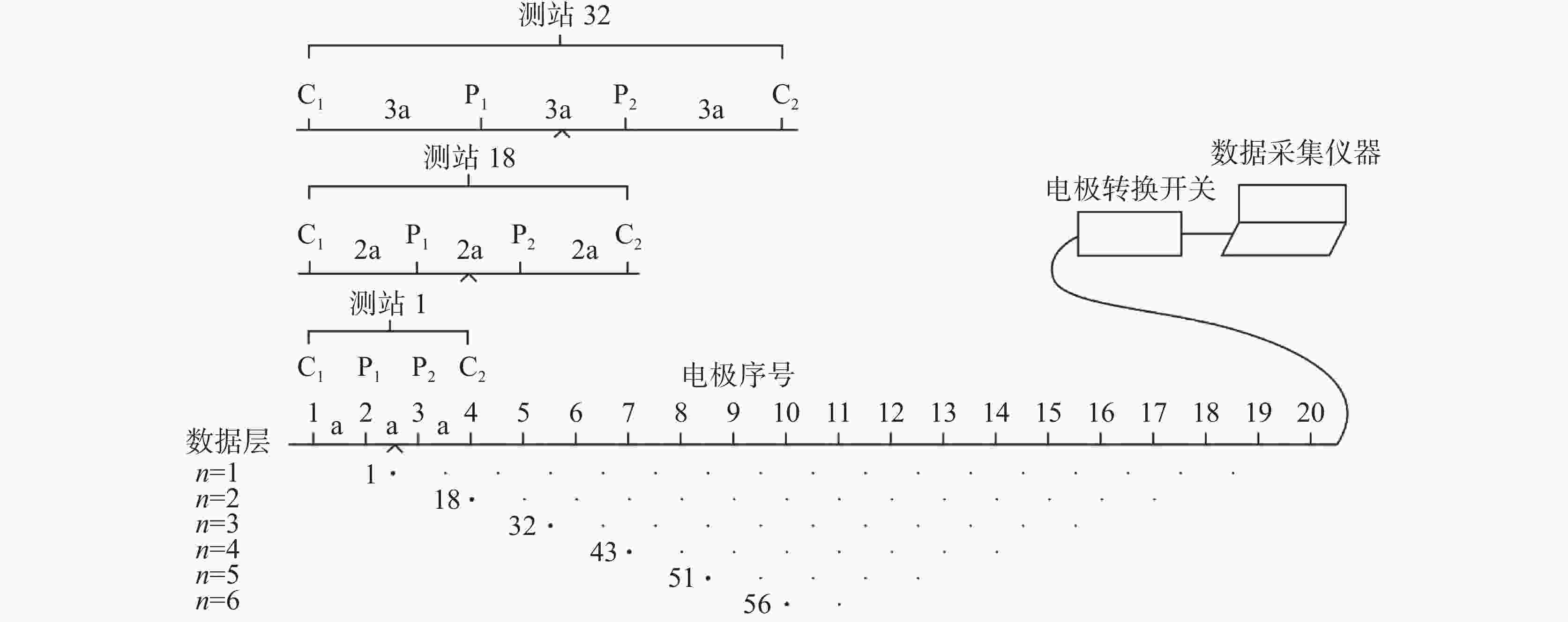
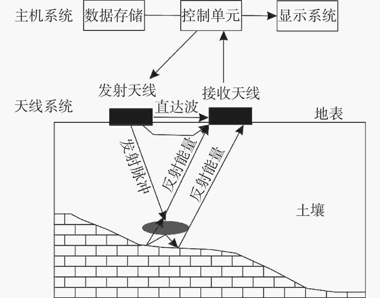
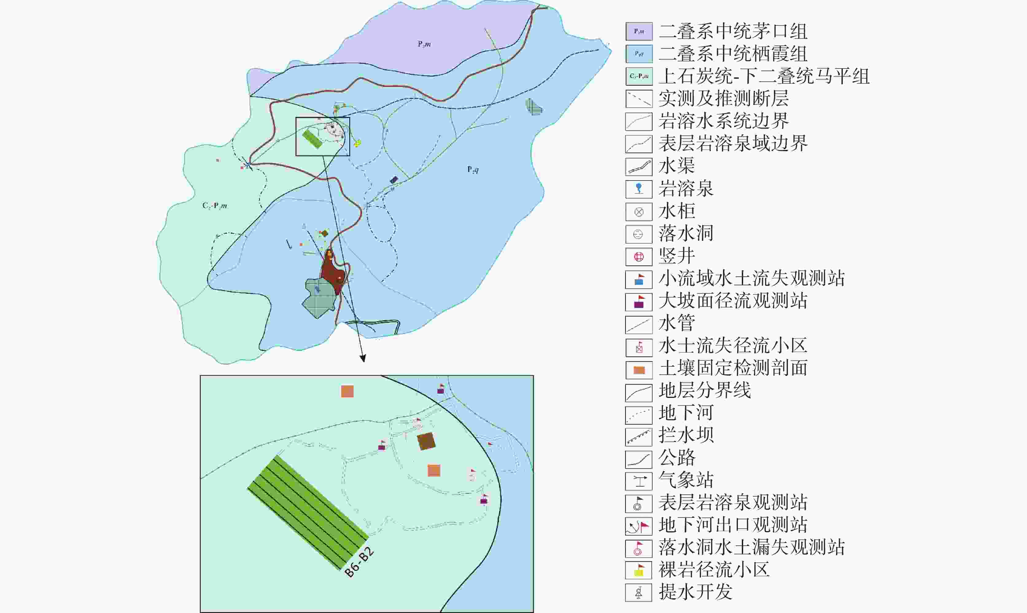
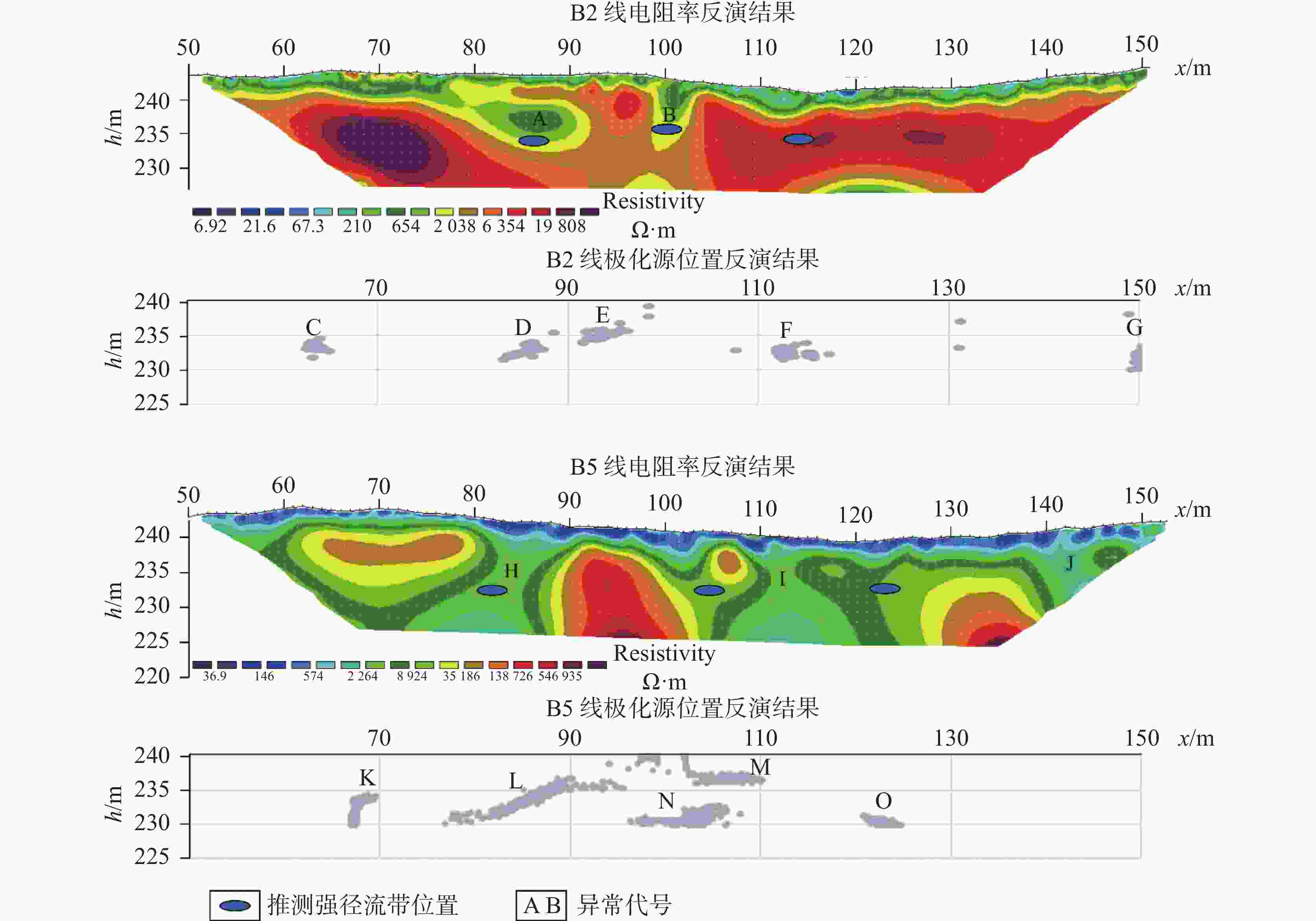
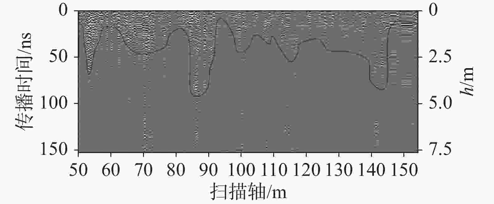
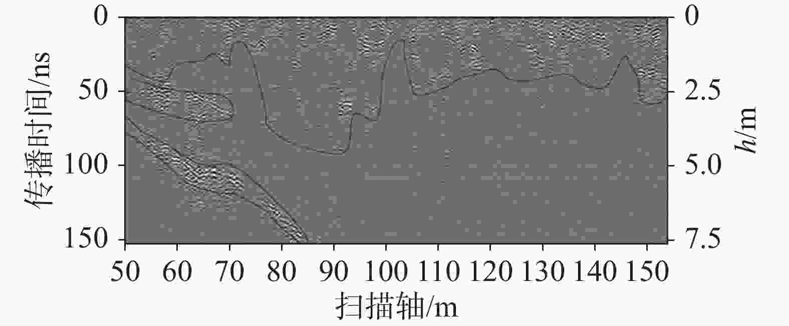
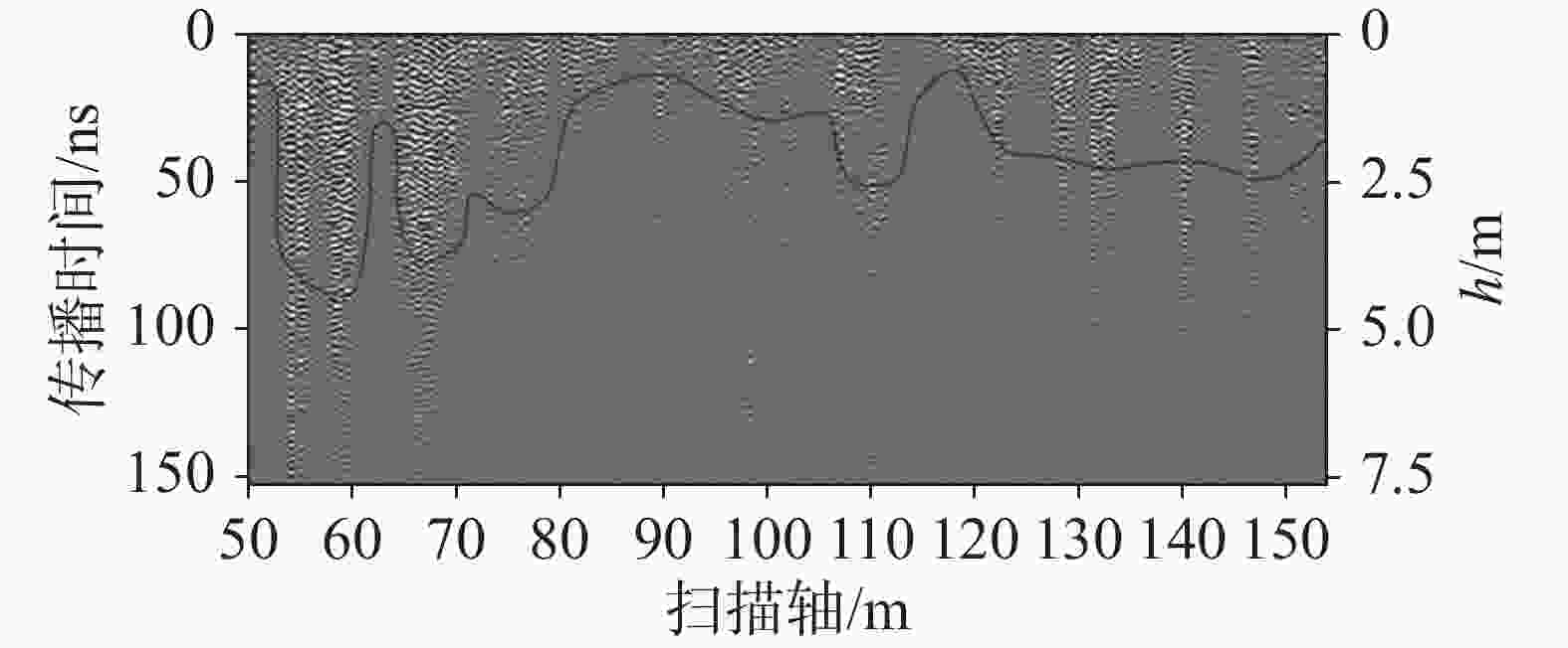
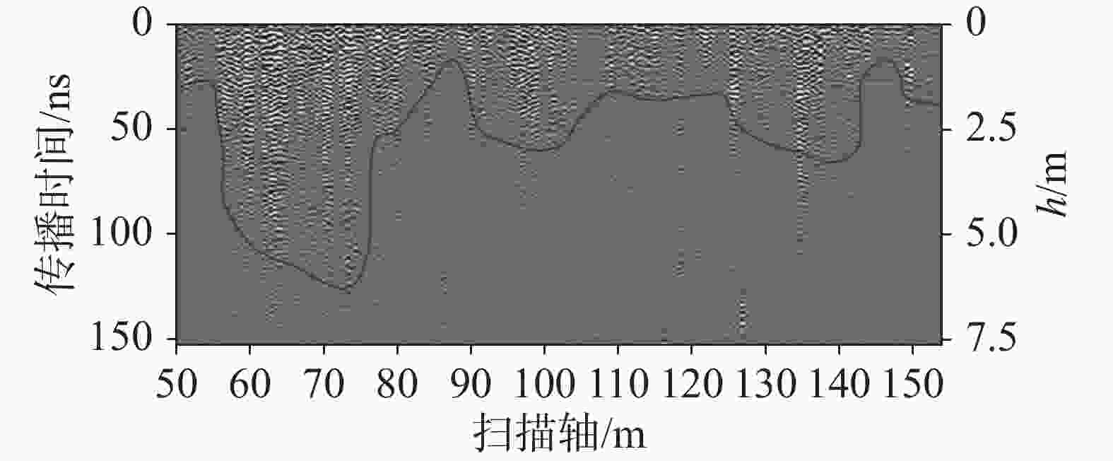
摘要: 表层岩溶带是岩溶学研究的重要部分,其结构的解译对表层岩溶带水循环特征及岩溶水调蓄功能的研究具有重要意义。利用综合物探方法(包括高密度电阻率法、自然电位法和地质雷达法),对平果市果化镇生态试验基地坡径流场的表层岩溶带空间结构特征进行了探测解译。通过对高密度电阻率数据和自然电位数据反演,获得坡径流场若干电阻率断面和极化源的空间分布特征,解译了3处强径流带发育的空间位置;通过地质雷达影像图划分了表层岩溶带发育深度。此外,坡径流场地西北侧有深部岩溶裂隙发育,向东南地势逐渐走低,岩溶裂隙也逐渐向面上扩大。研究结果表明,自然电位法是探测岩溶含水构造的有效方法,结合高密度电阻率法,可有效解译强径流带的空间发育位置,而地质雷达法可高分辨地探测表层岩溶带的发育厚度和浅部岩溶裂隙的发育情况;地质雷达法、高密度电阻率法和自然电位法的综合应用能有效探测表层岩溶带的结构特征,是解译表层岩溶带厚度和探测强径流带空间分布的有效手段。Abstract: The epikarst zone is widely distributed in the karst area of Southwest China, and it is the intersection zone of four circles (lithosphere, atmosphere, biosphere and hydrosphere). It is sensitive to environmental changes, in which rapid chemical reactions and strong karst actions are likely to take place. It records much information on short-term environmental change. It also has the function of regulating and storing karst water, and thus can effectively provide water resources for residents in karst mountainous areas. Therefore, the exploration and interpretation of the structure of epikarst zone is of great significance to the study of water cycle and the storage function of epikarst zone. In this study, comprehensive geophysical methods such as high-density resistivity method, spontaneous potential method and ground penetrating radar method have been used to explore and interpret the spatial structure characteristics of epikarst zone in slope runoff field of Guohua town ecological experiment base in Pingguo City. The high-density resistivity method can obtain the electrical structure section of slope runoff field by data inversion, and divide karst development areas by electrical structure. As an important method to interpret the development position of strong runoff belt, the spontaneous potential method can obtain the spatial position of polarization source through data inversion, and the generation of polarization source is closely related to water flow and electrochemical reaction between water and surrounding rock. With high resolution, the ground penetrating radar method is effective to interpret the development thickness of epikarst zone. The high-density resistivity method and the spontaneous potential method can be used to detect and comprehensively interpret the spatial position of the strong runoff belt in slope runoff field, and the ground penetrating radar method can be used to detect the thickness of the epikarst zone in the slope runoff field. In this study, according to the resistivity inversion cross-section and polarization source inversion results, the spatial positions of three strong runoff zones have been comprehensively explained, and their development depths vary between 5 m and 10 m. The development depth of the epikarst zone has been interpretated by the ground penetrating radar image. According to the development characteristics of epikarst zone in this area, the antenna frequency of the ground penetrating radar has been set as 400 MHz, and the radar wave reflection time has been converted into depth with the combination of the relevant geotechnical dielectric parameters of rock and soil. The development depth of epikarst zone in the slope runoff field is about 2.5 m (about 50 ns, with the speed of 10 cm·ns−1) The lateral variation of development thickness is significant. The accurate depth needs to be calibrated by the results of velocity measurement through drilling. In addition, there are deep karst fractures in the northwest of the slope runoff field, which gradually descend to the southeast and gradually expand to the surface. The research results show that the location of polarization source obtained by the inversion of spontaneous potential data can directly indicate the location of groundwater; therefore, the spontaneous potential method is effective to detect karst water-bearing structures. Combined with the results of high-density resistivity inversion section, the development location and spatial characteristics of strong runoff belt can be accurately interpreted, and the ground penetrating radar can detect the development thickness of epikarst zone and the development of shallow karst fracture structure with high resolution. In short, the integration of ground penetrating radar method, high-density resistivity method and spontaneous potential method can effectively detect the structural characteristics of epikarst zone, address the multi-solution problem, and hence an effective means to interpret the thickness of epikarst zone and to detect the spatial distribution of strong runoff belt.
-
表 1 研究区岩土介质介电常数、波速及电阻率
Table 1. Dielectric constant, wave velocity and resistivity of rock and soil medium in the study area
介质 相对介电常数 波速/cm·ns−1 电阻率/Ω·m 空气 1 30.0 ∞ 水 81 3.3 0.1~100 黏性干土 4~10 9.5~15.0 10~100 黏性湿土 10~30 5.4~9.5 1~10 干灰岩 7 11.3 100~10 000 湿灰岩 8 10.6 10~100 干混凝土 4~40 4.7~15.0 500~1 300 湿混凝土 10~20 6.7~9.5 50~200 表 2 电阻率反演结果及极化源反演结果推断异常体统计表
Table 2. Statistics of anomalous bodies inferred from inversion results of resistivity and polarization source
B2线 B5线 异常编号位置/m 发育深度/m 异常形态 异常编号位置/m 发育深度/m 异常形态 高密度 A 80~90 5~10 管道型 高密度 H 80~90 未见底 倾斜板状 B 99~103 未见底 竖直板状 I 100~125 未见底 倾斜板状 J 140~145 未见底 倾斜板状 自然电位 C 61~63 5~8 管道型 自然电位 K 68~70 5~10 竖直板状 D 82~86 5~8 倾斜板状 L 77~96 3~10 倾向板状 E 91~97 3~5 倾斜板状 M 102~110 4~5 水平板状 F 111~116 7~9 管道型 N 97~107 7~11 水平−倾斜板状 G 149~150 6~10 管道型 O 121~125 8~10 水平板状 表 3 坡径流场内解译强径流带空间位置统计表
Table 3. Statistics of the spatial position of strong runoff belt interpreted in slope runoff field
径流带1 径流带2 径流带3 B2线 B5线 B2线 B5线 B2线 B5线 代表性异常 A、D H、L B I、M、N F I、O 发育位置/m 85 82 100 105 114 123 发育深度/m 5~8 3~10 5~10 7~11 7~9 8~10 可靠性 强 强 中 强 弱 强 表 4 表层岩溶带发育深度及变化特征汇总表
Table 4. Summary of development depth and variation characteristics of epikarst zone
B2线 B3线 B4线 B5线 B6线 电磁波往返走时/
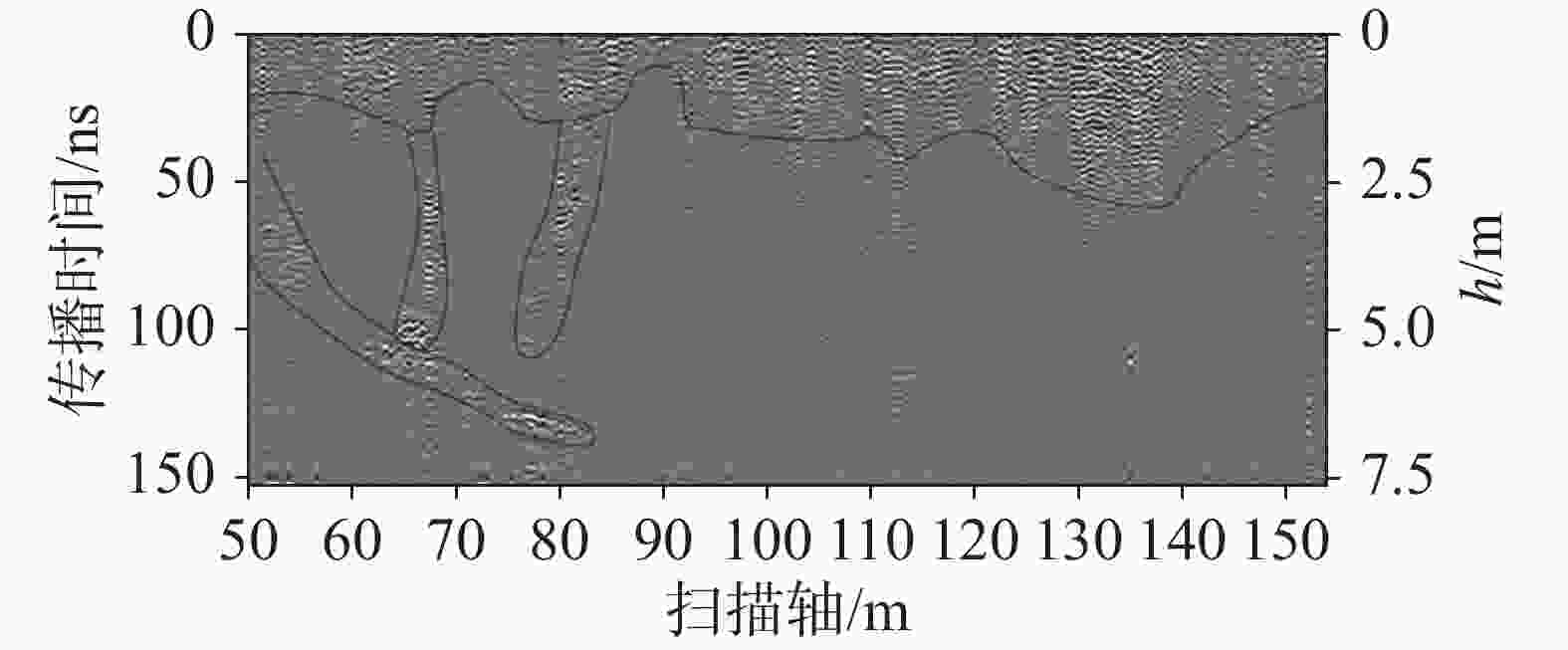
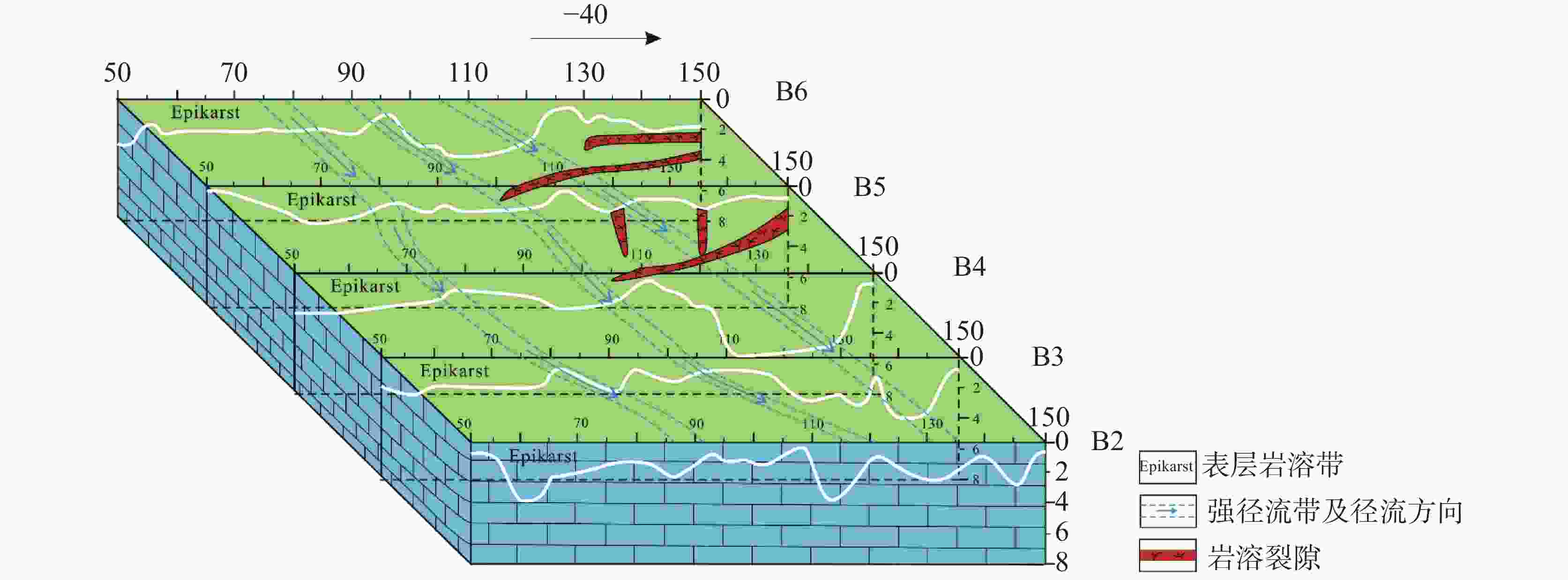
ns20~90 10~90 20~120 10~50 10~90 换算发育深度/m 1.0~4.5 0.5~4.5 1.0~6.0 0.5~2.5 0.5~4.5 剖面表层岩溶带发育特征 大部分发育深度1.5~2.5 m,个别地方发育较深如55 m、88 m、142 m等,宽度较小 呈现左侧深(可达4 m左右),中部最浅(1 m左右),右侧略深(2 m左右) 左侧发育较深,发育深度可达5~6 m,中部和右侧相对较浅,在1~3 m之间变化 相对较为平缓,左浅右深,左侧深部发育3条岩溶裂隙,两条竖直发育,一条水平
发育起伏变化较大,在80~100 m区间发育较深,可达4.5 m,其他区域在2 m左右;左侧中、深部各发育一条岩溶裂隙,倾斜
发育 -
[1] 袁道先, 蔡桂鸿. 岩溶环境学[M]. 重庆: 重庆出版社, 1988: 1-332. [2] 袁道先. 中国岩溶动力系统[M]. 北京: 地质出版社, 2002.YUAN Daoxian. Karst dynamic system in China[M]. Beijing: Geological Publishing House, 2002. [3] 袁道先, 蒋勇军, 沈立成, 蒲俊兵, 肖琼. 现代岩溶学[M]. 北京: 科学出版社, 2016.YUAN Daoxian, JIANG Yongjun, SHEN Licheng, PU Junbing, Xiao Qiong. Modern karstology[M]. Beijing: Science Press, 2016. [4] 袁道先. 碳循环与全球岩溶[J]. 第四纪研究, 1993, 13(1): 1-6.YUAN Daoxian. Carbon cycle and global karst[J]. Quaternary Sciences, 1993, 13(1): 1-6. [5] 章程. 岩溶动力学理论与现代岩溶学发展[J]. 中国岩溶, 2022, 41(3):378-383. doi: 10.11932/karst20220305ZHANG Cheng. Theory of karst dynamics and development of modern karst science[J]. Carsologica Sinica, 2022, 41(3): 378-383. doi: 10.11932/karst20220305 [6] 李玉辉, 章程, 庄晓东, 丁文荣, 俞筱押. 中国岩溶研究进展的哲学认知与展望[J]. 中国岩溶, 2022, 41(3):401-413. doi: 10.11932/karst20220308LI Yuhui, ZHANG Cheng, ZHUANG Xiaodong, DING Wenrong, YU Xiaoya. Philosophical cognition and prospect of karst research in China[J]. Carsologica Sinica, 2022, 41(3): 401-413. doi: 10.11932/karst20220308 [7] 蒋忠诚, 袁道先. 表层岩溶带的岩溶动力学特征及其环境和资源意义[J]. 地球学报, 1999, 20(3):302-308. doi: 10.3321/j.issn:1006-3021.1999.03.014JIANG Zhongcheng, YUAN Daoxian. Dynamics features of the epikarst zone and their significance in environments and resources[J]. Acta Geoscientia Sinica, 1999, 20(3): 302-308. doi: 10.3321/j.issn:1006-3021.1999.03.014 [8] 蒋忠诚, 章程, 罗为群, 肖琼, 吴泽燕. 我国岩溶地区碳汇研究进展与展望[J]. 中国岩溶, 2022, 41(3):345-355. doi: 10.11932/karst20220302JIANG Zhongcheng, ZHANG Cheng, LUO Weiqun, XIAO Qiong, WU Zeyan. Research progress and prospect of carbon sink in karst region of China[J]. Carsologica Sinica, 2022, 41(3): 345-355. doi: 10.11932/karst20220302 [9] 章程, 肖琼. 桂林漓江水体溶解无机碳迁移与水生光合碳固定研究[J]. 中国岩溶, 2021, 40(4):555-564.ZHANG Cheng, XIAO Qiong. Study on dissolved inorganic carbon migration and aquatic photosynthesis sequestration in Lijiang river, Guilin[J]. Carsologica Sinica, 2021, 40(4): 555-564. [10] 闫钇全, 刘琦, 邓大鹏, 王涵. 表层岩溶裂隙带土壤地表流失/地下漏失室内模拟实验[J]. 中国岩溶, 2022, 41(2):240-248. doi: 10.11932/karst20220206YAN Yiquan, LIU Qi, DENG Dapeng, WANG Han. Laboratory simulation study on soil surface loss and underground leakage in the epikarst fissure zone[J]. Carsologica Sinica, 2022, 41(2): 240-248. doi: 10.11932/karst20220206 [11] 覃小群, 蒋忠诚. 表层岩溶带及其水循环的研究进展与发展方向[J]. 中国岩溶, 2005, 24(3):250-254. doi: 10.3969/j.issn.1001-4810.2005.03.015QIN Xiaoqun, JIANG Zhongcheng. A review on recent advances and perspective in epikarst water study[J]. Carsologica Sinica, 2005, 24(3): 250-254. doi: 10.3969/j.issn.1001-4810.2005.03.015 [12] 彭韬, 周长生, 宁茂岐, 付磊, 戴德求, 王世杰. 基于探地雷达解译的喀斯特坡地表层岩溶带空间分布特征研究[J]. 第四纪研究, 2017, 37(6):1262-1270. doi: 10.11928/j.issn.1001-7410.2017.06.10PENG Tao, ZHOU Changsheng, NING Maoqi, FU Lei, DAI Deqiu, WANG Shijie. Study on spatial distribution of epikarst zone on plateau karst slope based on ground-penetrating radar[J]. Quaternary Sciences, 2017, 37(6): 1262-1270. doi: 10.11928/j.issn.1001-7410.2017.06.10 [13] 高强山, 彭涛, 付磊, 王世杰, 曹乐, 程倩云. 探地雷达技术对表层岩溶带典型剖面组构刻画与界面识别[J]. 中国岩溶, 2019, 38(5):759-765. doi: 10.11932/karst20190512GAO Qiangshan, PENG Tao, FU Lei, WANG Shijie, CAO Le, CHENG Qianyun. Structure description and interface recognition on epikarst typical profiles using GPR technology[J]. Carsologica Sinica, 2019, 38(5): 759-765. doi: 10.11932/karst20190512 [14] Iuliano T, Mauriello P, Patella D. Looking inside mount vesuvius by potential fields integrated probability tomographies[J]. Journal of Volcanology and Geothermal Research, 2002, 113(3-4): 363-378. doi: 10.1016/S0377-0273(01)00271-2 [15] Fritjof Fagerlund, Graham Heinson. Detecting subsurface groundwater flow in fractured rock using self-potential methods[J]. Environmental Geology, 2003, 43: 782-794. doi: 10.1007/s00254-002-0693-x [16] 刘永亮, 甘伏平, 韩凯, 邬健强, 梁东辉, 张伟, 郑智杰, 刘伟, 陈贻祥. 自然电位数据阻尼最小二乘逐步解析反演研究:以桂林市寨底地下河为例[J]. 地球物理学进展, 2018, 34(2):775-780.LIU Yongliang, GAN Fuping, HAN Kai, WU Jianqiang, LIANG Donghui, ZHANG Wei, ZHENG Zhijie, LIU Wei, CHEN Yixiang. Damped least squares gradually analysis inversion of self-potential data: Take Zhaidi underground-river in Guilin for example[J]. Progress in Geophysics, 2018, 34(2): 775-780. [17] Patella D. Introduction to ground surface self-potential tomography[J]. Geophysical Prospecting, 1997, 45(4): 653-681. doi: 10.1046/j.1365-2478.1997.430277.x [18] 冯亮, 邢尚鑫, 王森, 李冰. 高密度电法在新建住宅区地下溶洞勘查中的应用[J]. 矿产勘查, 2020, 11(7):1461-1464. doi: 10.3969/j.issn.1674-7801.2020.07.021FENG Liang, XING Shangxin, WANG Sen, LI Bing. Application of high-density resistivity method in surveying underground karst cave in newly-built residential area[J]. Mineral Exploration, 2020, 11(7): 1461-1464. doi: 10.3969/j.issn.1674-7801.2020.07.021 [19] 安邦超. 高密度电法在岩溶段填方路基的应用研究[J]. 水利科技与经济, 2020, 26(8):81-83.AN Bangchao. Application of high-density electrical method in filling subgrade of karst section[J]. Water Conservancy Science and Technology and Economy, 2020, 26(8): 81-83. [20] 韩鹏. 高密度电阻率法在探测不同充填类型溶洞中的正反演研究[J]. 地质与勘探, 2020, 56(6):1219-1225. doi: 10.12134/j.dzykt.2020.06.010HAN Peng. Forward modeling and inversion of the high-density resistivity method in detecting karst caves of different filling types[J]. Geology and Exploration, 2020, 56(6): 1219-1225. doi: 10.12134/j.dzykt.2020.06.010 [21] 李望明, 易强, 刘声凯, 肖利权, 李俊. 湘西北岩溶石山缺水地区直流电法找水实例[J]. 物探与化探, 2020, 44(6):1294-1300.LI Wangming, YI Qiang, LIU Shengkai, XIAO Liquan, LI Jun. An example of DC method for water exploration in the karst mountain water shortage area of northwest Hunan[J]. Geophysical & Geochemical Exploration, 2020, 44(6): 1294-1300. [22] 劳文科, 祁晓凡, 刘慧敏, 蒋忠诚, 覃小群, 覃星铭. 广西果化龙何地区表层带岩溶水系统及其水资源特征[J]. 中国岩溶, 2008, 27(2):122-128. doi: 10.3969/j.issn.1001-4810.2008.02.005LAO Wenke, QI Xiaofan, LIU Huimin, JIANG Zhongcheng, QIN Xiaoqun, QIN Xingming. Characters of epikarst water system and water resources in Longhe, Guohua, Guangxi[J]. Carsologica Sinica, 2008, 27(2): 122-128. doi: 10.3969/j.issn.1001-4810.2008.02.005 -


 下载:
下载:
