Distribution characteristics and genesis analysis of geological relics in Zhaoyang district, Zhaotong City, Yunnan Province
-
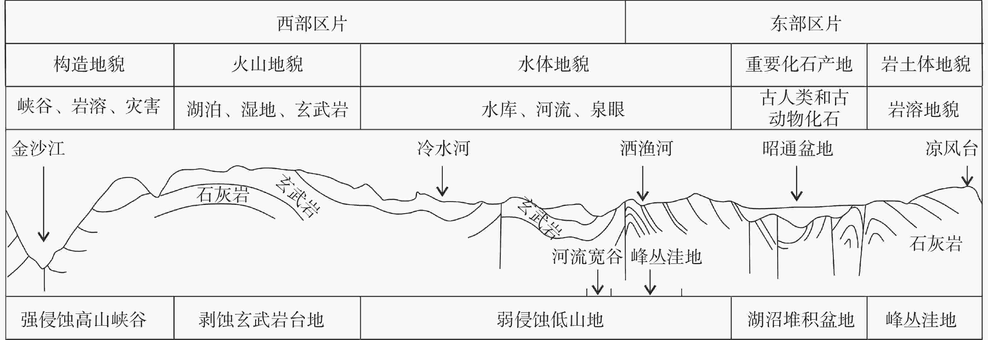
摘要: 文章在收集详细地质遗迹野外调查资料的基础上,对滇东北地区昭通市昭阳区的各种地质遗迹进行综合分类和成因分析。结果表明:昭阳区地质遗迹可分为西部和东部2大区片,西部为以大山包为代表的玄武岩台地,集火山岩地貌、高原湖泊和湿地为一体;东部为以昭通山间盆地为中心的碳酸盐岩岩溶地貌,附有古生物化石景观;碳酸盐岩、泥页岩、砂岩、玄武岩等丰富的岩性及其他作为隔水岩系和含水岩系的相间分布为岩溶作用和岩溶地貌的差异奠定了基础;不同程度的断裂—褶皱形成的构造地貌是现今东、西地质遗迹分异的主控因素;地层岩性—构造地貌背景下的水文条件为塑造丰富的地质景观提供了外部动力因素。Abstract:
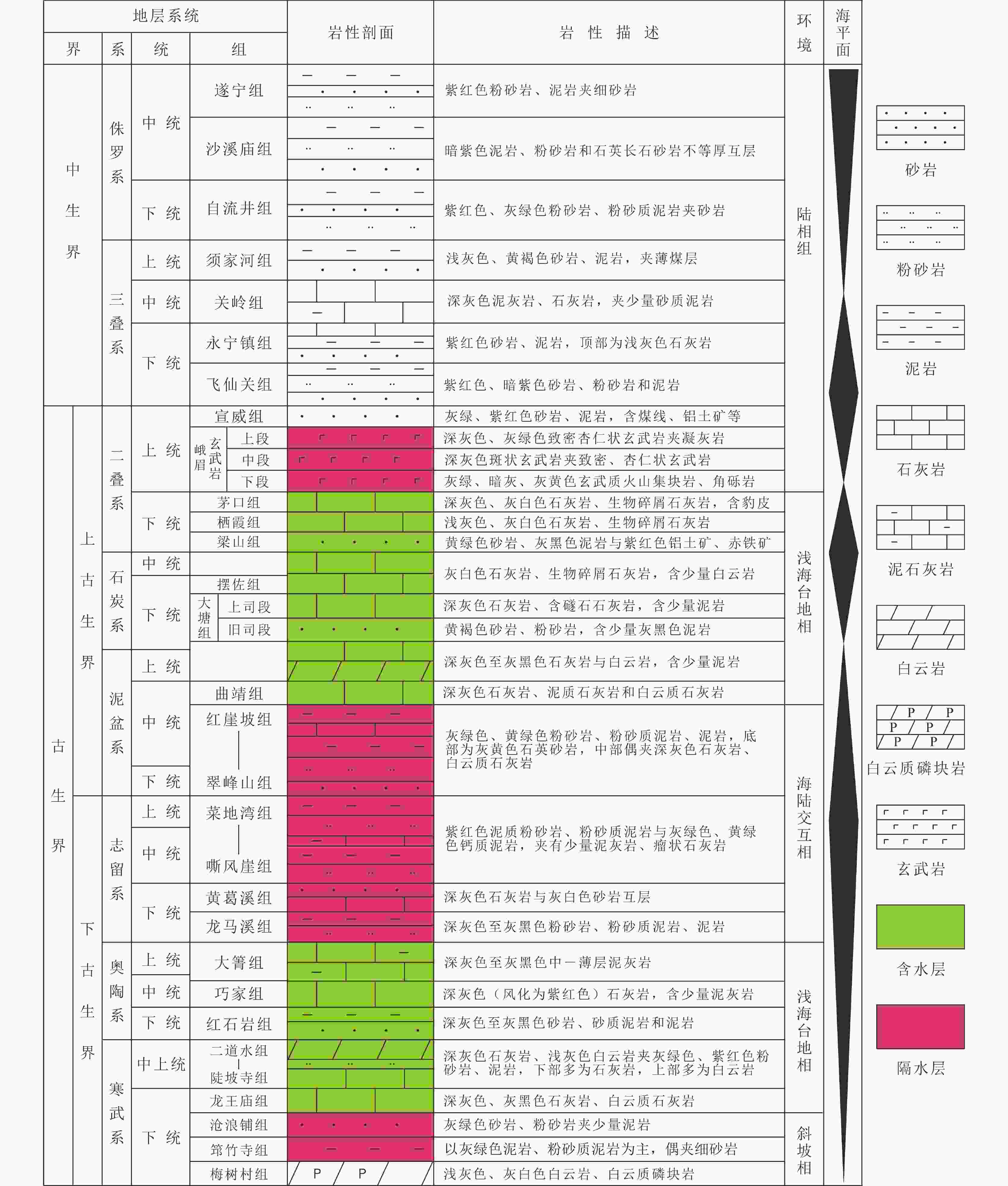
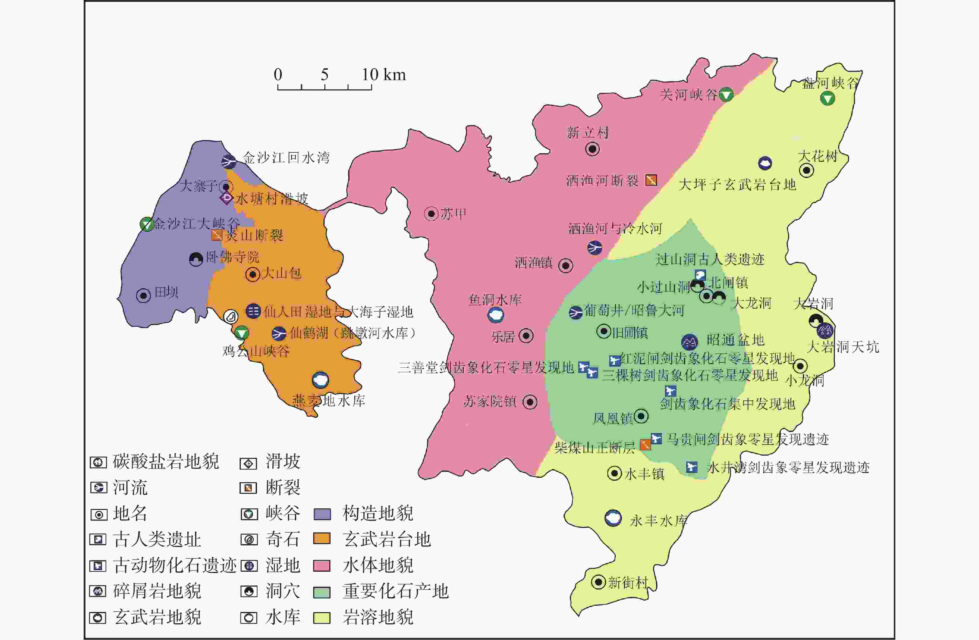
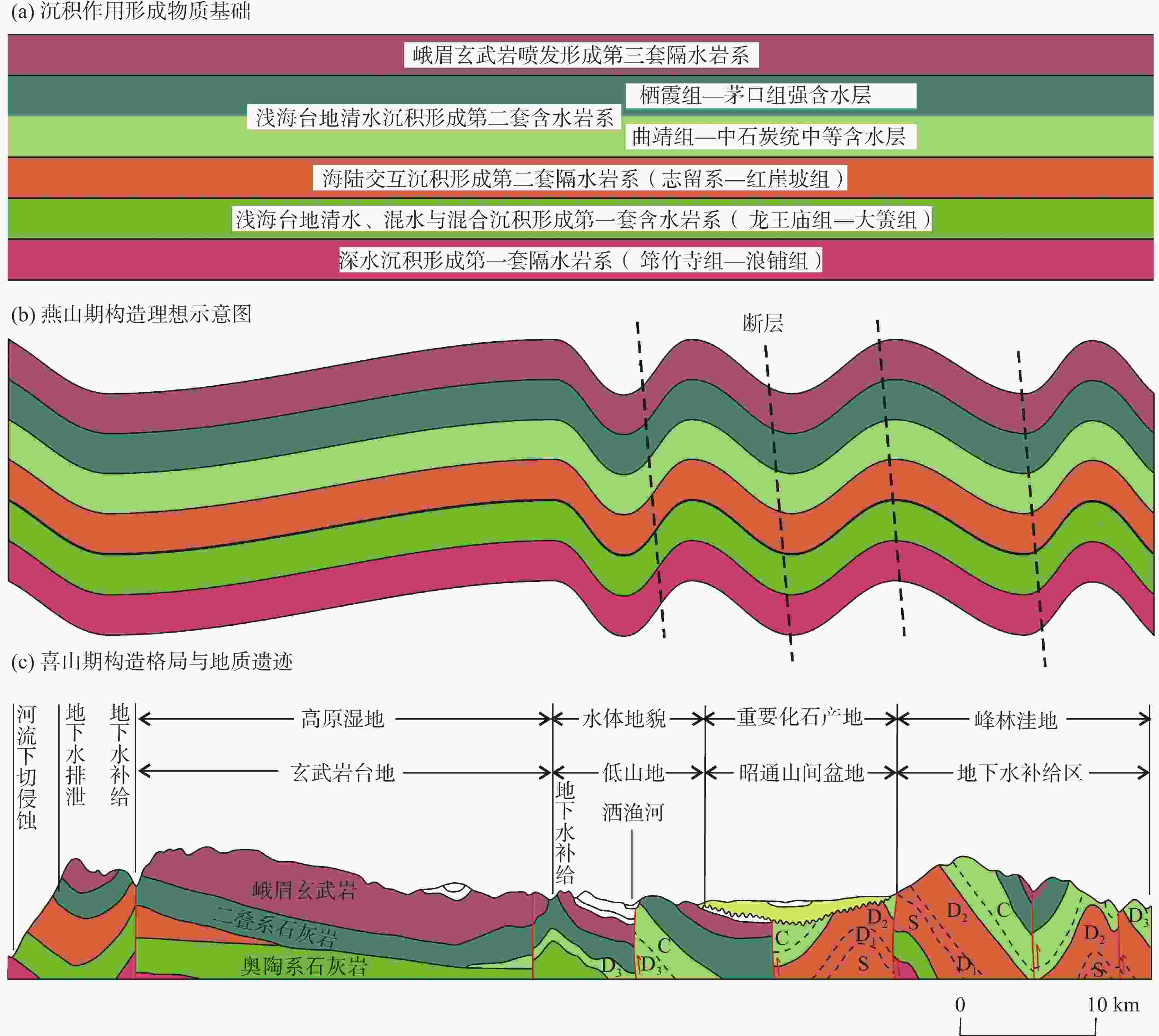
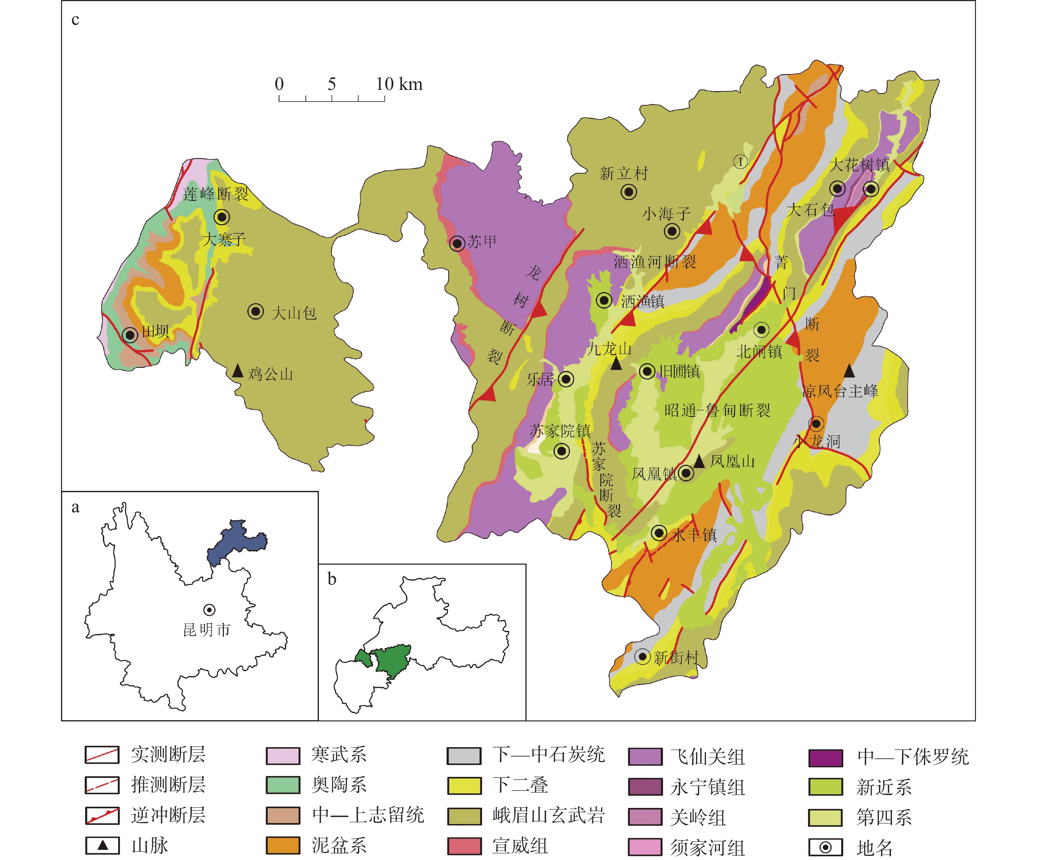
Geological relics are one of the important components of geoscience culture, so studies on their distribution characteristics and genesis are helpful to the effective investigation and evaluation of the landscape resources in geological relics. Zhaotong City is located on the southeastern margin of the Tibetan Plateau in the northeastern Yunnan Province of Southwest China. It belongs to the Yangtze plate of South China, which is located at the southwest edge of the Yangtze block—a secondary tectonic unit within the plate. The formation and distribution of landscapes of geological relics in Zhaoyang district are closely related to the formation and evolution of the Zhaotong intermountain basin. On the basis of detailed field investigations of geological relics, this study comprehensively classifies and analyzes the genesis of various geological relics in Zhaoyang district of Zhaotong City in northeastern Yunnan Province. The strata in the Zhaoyang area are fully exposed, ranging from the Cambrian Meishucun Formation (Zhongyicun member of Dengying Formation) to the Quaternary system (Neogene). The Cambrian and Ordovician systems are mainly exposed in Yanshan township and Dazhaizi township by the Jinsha river, and are mainly buried deep underground in other areas. The Meishucun Formation at the bottom of the Cambrian is a phosphate-bearing rock series, with the upper Qiongzhusi Formation and Canglangpu Formation being a combination of terrigenous sandstone and mudstone. The Longwangmiao Formation to the Erdaoshui Formation and the Ordovician Formation at the top of the lower Cambrian are mostly composed of carbonate rocks. Meishucun Formation at the bottom of the Cambrian is composed of the phosphorus-bearing rock series. The upper Qiongzhusi Formation and Canglangpu Formation are the combination of terrigenous sand and mudstone. The top of the lower Cambrian Longwangmiao Formation to the Erdaoshui Formation and the Ordovician are mostly composed of carbonate rocks. The combination of terrigenous sand and mudstone, accompanied by muddy limestone, is developed in Hong'anpo Formation of the Silurian system to the upper part of middle Devonian. Thick carbonate deposits are developed in Qujing Formation at the top of middle Devonian to the Maokou Formation of the lower Permian. From the Xuanwei Formation at the top of Permian to the Cretaceous, there are only sporadic outcrops—mainly terrigenous sand and mudstone—in Zhaoyang district. The Paleogene mainly consists of sand, mudstone and thick lignite. The bottom of the Neogene is mainly composed of conglomerate with a small amount of limestone and sandstone; the clay soil is interbedded with gravel in the middle part; the grey clay soil is interbedded with siltstone at the bottom. The Quaternary system is filled with swampy sediments of clays, silts, etc. and abundant biological fossils, such as ostracods, stonewort, ichthyodont and viviparus. The results show that the geological relics of Zhaoyang district can be divided into western region and eastern region. The western region is a basalt platform like Dashanbao, including volcanic landform, plateau lakes and wetland. The eastern region takes carbonate rock karst landform of Zhaotong mountain basin as the center by paleontological fossil landscape. The abundant lithology, like carbonate rock, shale, sandstone, basalt and so on, contributes to karst development and karst geomorphology difference. The tectonic landforms formed by different degrees of fault-fold are the main factors of the differentiation of geological relics. Under background of stratigraphic lithology and tectonic geomorphology, hydrologic conditions provide external dynamic factors for abundant geological landscapes. Our research is of great scientific value of geological relics resources in Zhaotong, and also provides a basis for studies on mammal fossils in Late Neogene. It is concluded as follows, (1) Geological relics of Zhaoyang district in Zhaotong City include canyon landform, volcanic landform, karst landform, plateau lake, wetland and fossil landscape, etc., with great value of tourism. (2) Abundant stratigraphic lithology is the basis for the development of different geological relics. Two sets of outcrops of carbonate rocks widely shaped the modern geological landscape with karst landform and water landform in the study area. Vertically, the strata of Zhaoyang district are characterized by an interphase pattern of three sets of water-resisting rock series and two sets of water-bearing rock series, being the geological foundation of geological relics. From the bottom to the top of strata are distributed the water-resisting rock series mainly composed of mudstone from the Cambrian Qiongzhusi Formation to the Canglangpu Formation, the water-bearing rock series composed of carbonate rock and diamictite from the Cambrian Longwangmiao Formation to the Ordovician Daqing Formation, the water-resisting rock series mainly composed of sand and mudstone with marine-terrestrial transitional facies from the Silurian Longmaxi Formation to the Devonian Hongyapo Formation, the water-bearing rock series composed of carbonate rock from the Devonian Qujing Formation to the Permian Maokou Formation, and the water-resisting rock series composed of the Permian Emei basalt. (3) The tectonic process forms a structural pattern of east-west differences in Zhaoyang district, controlling the distribution pattern of geological relics in this district. The reasons are as follows: the Indosinian Movement caused the overall uplift of the northeastern Yunnan into land; the Yanshan movement formed open and gentle folds in the west and relatively tight folds and large-scale faults in the east, resulting in east-west differences; the Xishan movement formed the Zhaotong intermountain basin, caused strong downward erosion of rivers, and controlled the direction of groundwater runoff, becoming a direct controlling factor for the formation of geological relics in Zhaoyang district. -
Key words:
- geological relic /
- basalt platform /
- biofossil /
- karst landform /
- northeastern Yunnan
-
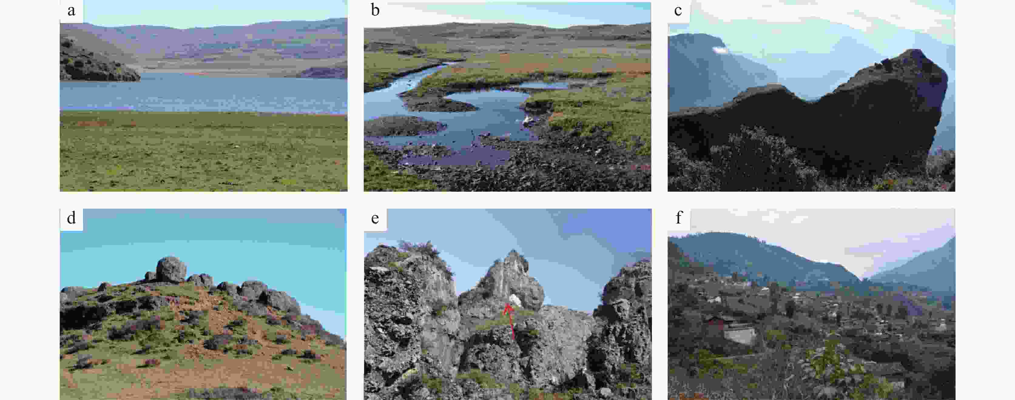
图 4 昭阳区西部玄武岩台地地质遗迹
a.高原人工湖泊(跳蹲河水库)及周围的山川和草场,黑颈鹤越冬栖息地(昭阳区大山包自然保护区) b.大山包仙人田湿地 c.鸡公山及鸡公山大峡谷d.玄武岩石球,直径为50~140 cm e.石灰岩构造崩塌,箭头所示方解石酷似“卧佛”,长60 cm,在峡谷边缘或形成石灰岩地貌景观,亦可形成地质灾害(炎山乡) f.金沙江边支流山体上的大型滑坡全貌及滑坡主体,滑坡体上有密集的村庄(大寨子乡水塘村)
Figure 4. Geological relics of basalt platform in western Zhaoyang district
a. plateau artificial lake (Tiaodunhe reservoir) and its surrounding mountains and grasslands; it is the wintering habitat for black-necked cranes called Dashanbao nature reserve in Zhaoyang district; b. Dashanbao Xianrentian wetland; c. Jigong mountain and its grand canyon d. basalt stone ball with diameter of 50–140 cm; e. tectonic collapse of limestone; the calcite indicated by arrow resembles "reclining Buddha" with length of 60 cm in the canyon rim, which may form limestone geomorphic landscape or geological disaster in Yanshan township; f. general view and main body of large-scale landslide on the hill of tributary of Jinsha river; there is a dense village on the slope, called Shuitang village in Dazhaizi township
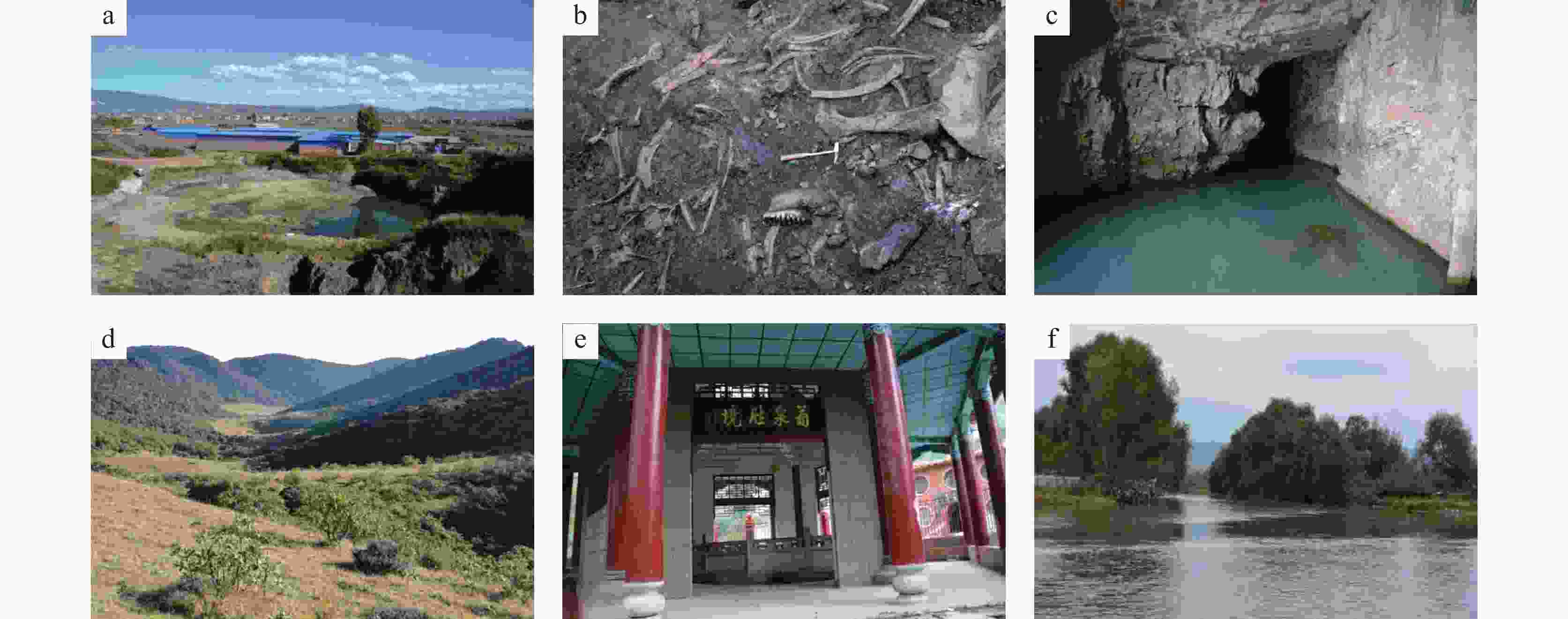
图 5 东部昭通盆地及周边山地地质遗迹
a.昭通盆地南部煤化石遗迹,蓝色房子为养殖场,地层由灰黑色厚层褐煤与深灰色粉砂质泥岩组成,遗迹长127 m,宽116 m b.褐煤层中剑齿象化石埋藏状态(水塘坝) c.大龙洞中的水潭及潭中石灰岩块,可能为洞顶掉落(北闸镇大龙洞公园内,小洞洞口宽约2 m) d.昭通盆地东缘岩溶地貌中的峰丛洼地和串珠状分布的落水洞(昭阳区小龙洞乡大咀口村附近) e.昭通盆地西部昭鲁河边的葡萄井(昭阳区旧圃镇) f.昭通盆地西部洒渔河谷地(昭鲁河与冷水河交汇形成洒渔河)
Figure 5. Geological relics of the eastern Zhaotong basin and of its surrounding mountains
a. coal fossil relics in southern Zhaotong basin; the blue house is culturing farm; the formation is composed of gray black thick lignite and dark gray silty mudstone; the relics are 127 m long and 116 m wide b. burial status of stegodon fossils in lignite reservoir in Shuitang dam; c. the water pool in Dalong cave and the limestone block; the limestone block may be fell from the roof of the cave; the entrance of the small cave is about 2 m wide in the Dalong cave park in Beizha town; d. peak cluster depression and beaded sinkhole in the eastern margin of Zhaotong basin, near Dajukou village, Xiaolongdong township, Zhaoyang district; e. grape well by the Zhaolu river in the west of Zhaotong basin, Jiupu town, Zhaoyang district f. valley of Sayu river in western Zhaotong basin; Sayu river is converged by Zhaolu river and Lengshui river
表 1 昭阳区主要地质遗迹类型
Table 1. Main types of geological relics in Zhaoyang district
大类 类 亚类 主要地质遗迹 地层 构造单元 地质灾害 灾害景观 滑坡 水塘村滑坡 茅口组 莲峰断裂带 地貌景观 构造地貌 峡谷 大山包鸡公山大峡谷 二叠系 观音岩断裂 火山岩地貌 火山岩地貌 大山包鸡公山(柱状节理) 峨眉玄武岩 玄武岩高地 水文地貌 湿地—沼泽 大山包仙人田湿地 湖泊 大山包仙鹤湖(跳蹲河水库) 乐居鱼洞水库 白莎背斜南末端 岩土体地貌 岩溶地貌 北闸镇大龙洞 茅口组 箐门背斜北西翼 大垭口村小型峰丛洼地和峰丛谷地 地质历史 重要化石产地 古人类化石 塘房村大过山洞古人类遗址 昭通组 五寨向斜北西翼 古动物化石 水塘坝剑齿象集中发现地 昭通盆地 三善堂剑齿象化石零星发现地 三棵树剑齿象化石零星发现地 红泥闸剑齿象化石零星发现地 -
[1] DZ/T 0303-2017. 地质遗迹调查规范[S]. 北京: 中国标准出版社, 2017.DZ/T 0303-2017. Regulations for geoheritage investigation[S]. Beijing: Standards Press of China, 2017. [2] 邓亚东, 史文强, 罗书文, 孟庆鑫. 基于乡镇区划的地质遗迹资源综合价值评价:以盐津县为例[J]. 中国岩溶, 2018, 37(6):932-939.DENG Yadong, SHI Wenqiang, LUO Shuwen, MENG Qingxin. Comprehensive value evaluation of geological heritage resources based on township division: Taking Yanjin county as an example[J]. Carsologica Sinica, 2018, 37(6): 932-939. [3] 高梦瑶, 殷小艳. 地质文化村(镇)评审授牌、天然富硒土地认定与标识管理相关工作即将启动[J]. 地质论评, 2020, 66(3):610.GAO Mengyao, YIN Xiaoyan. The work related to "geological culture village (town)" assessment and licensing, "natural selenium-rich land" identification and logo management launched soon[J]. Geological Review, 2020, 66(3): 610. [4] 张东涛, 胡朝俊, 闫亚蕾, 何勇, 张介辉, 张卓. 梅珏. 昭通地区现今构造应力场分布特征及成因机制[J]. 天然气工业, 2021, 41(Suppl.1): 24-29.ZHANG Dongtao, HU Chaojun, YAN Yalei, HE Yong, ZHANG Jiehui, ZHANG Zhuo, MEI Jue. Distribution characteristics and genetic mechanism of present tectonic stress field in Zhaotong area[J]. Natural Gas Industry, 2021, 41(Suppl.1): 24-29. [5] 王小娜, 于湘伟, 章文波. 昭通地区地震层析成像及彝良震区构造分析[J]. 地球物理学进展, 2014, 29(4): 1573-1580.WANG Xiaona, YU Xiangwei, ZHANG Wenbo. Seismic tomography at Zhaotong region and analysis of seismotectonic in Yiliang area[J]. Progress in Geophysics, 2014, 29 (4): 1573-1580. [6] 常祖峰, 周荣军, 安晓文, 陈宇军, 周青云, 李鉴林. 昭通—鲁甸断裂晚第四纪活动及其构造意义[J]. 地震地质, 2014, 36(4):1260-1279.CHANG Zufeng, ZHOU Rongjun, AN Xiaowen, CHEN Yujun, ZHOU Qingyun, LI Jianlin. Late-Quaternary activity of the Zhaotong–Ludian fault zone and its tectonic implication[J]. Seismology and Geology, 2014, 36(4): 1260-1279. [7] 张杰, 陈革, 任清军, 史俊波. 昭通—鲁甸断褶带南段构造变形序列与应力分析[J]. 科学技术与工程, 2018, 18(6): 47-56.ZHANG Jie, CHEN Ge, REN Qingjun, SHI Junbo. Tectonic deformation sequences and stress analysis in the southern segment of the Zhaotong–Ludian fault folding zone[J]. Science Technology and Engineering, 2018, 18 (6): 47-56. [8] 郑荣椿. 云南昭通第三纪褐煤盆地成因的探讨:对“岩溶侵蚀盆地”成因的异议[J]. 中国岩溶, 1985(Suppl.1):161-170.ZHENG Rongchun. Discussion on the origin of Tertiary lignite basin of Zhaotong county, Yunnan: Some objections to the origin of "erosion karst basin"[J]. Carsologica Sinica, 1985(Suppl.1): 161-170. [9] 谭富荣, 崔伟雄, 张元忠. 昭通盆地茨营组沉积演化及聚煤规律研究[J]. 中国煤炭地质, 2014, 26(2):1-5.TAN Furong, CUI Weixiong, ZHANG Yuanzhong. A study on Ciying Formation sedimentary evolution and coal accumulation pattern in Zhaotong basin[J]. Coal Geology of China, 2014, 26(2): 1-5. [10] 任娟刚, 洪增林, 张静, 唐力, 刘晓峰, 秦臻, 王鹏, 王研. 陕西宁强禅家岩天坑群喀斯特地质遗迹特征及成因[J]. 中国岩溶, 2021, 40(3):539-547.REN Juangang, HONG Zenglin, ZHANG Jing, TANG Li, LIU Xiaofeng, QIN Zhen, WANG Peng, WANG Yan. Features of geological relics and genesis of the Chanjiayan Tiankeng group in Ningqiang, Shaanxi Province[J]. Carsologica Sinica, 2021, 40(3): 539-547. [11] 王辉, 李江海, 吴桐雯. 太行山地质遗迹特征与成因分析[J]. 北京大学学报(自然科学版), 2018, 54(3):546-554.WANG Hui, LI Jianghai, WU Tongwen. Characteristics and genesis of geoheritage resources of Taihang mountain[J]. Acta Scientiarum Naturalium Universitatis Pekinensis, 2018, 54(3): 546-554. [12] 尹祝, 黄鸿新, 罗平, 魏昌盛. 三清山世界地质公园地质遗迹分类及其地学意义[J]. 西北地质, 2018, 51(4):276-283.YIN Zhu, HUANG Hongxin, LUO Ping, WEI Changsheng. Geoheritage classification of the Sanqingshan world geopark and their geological significance[J]. Northwestern Geology, 2018, 51(4): 276-283. [13] 曹晓娟, 姜伏伟, 陈友智, 董颖, 杨宏斌. 武陵山地区红色岩溶景观形成地质条件与演化模式研究[J]. 中国岩溶, 2020, 39(6):945-951.CAO Xiaojuan, JIANG Fuwei, CHEN Youzhi, DONG Ying, YANG Hongbin. Geological conditions and evolution model of red karst landscape in the Wulingshan area, China[J]. Carsologica Sinica, 2020, 39(6): 945-951. [14] 向敬伟, 李江风, 王蕾, 周学武, 胡学君, 叶茂松. 湖北长阳清江地质公园地质遗迹特征及地学意义[J]. 地球学报, 2017, 38(4):561-568.XIANG Jingwei, LI Jiangfeng, WANG Lei, ZHOU Xuewu, HU Xuejun, YE Maosong. Geological heritage resources characteristics and geographic significance of the Qingjiang geopark in Changyang, Hubei Province[J]. Acta Geoscientica Sinica, 2017, 38(4): 561-568. [15] 陈安泽. 论旅游地学与地质公园的创立及发展, 兼论中国地质遗迹资源:为庆祝中国地质科学院建院60周年而作[J]. 地球学报, 2016, 37(5):535-561.CHEN Anze. The establishment and development of tourism earth-science and geopark, and geoheritage resources in China: Celebrating the 60th anniversary of Chinese Academy of Geological Sciences[J]. Acta Geoscientica Sinica, 2016, 37(5): 535-561. [16] 方世明, 李江风, 赵来时. 地质遗迹资源评价指标体系[J]. 地球科学(中国地质大学学报), 2008, 17(2):285-288.FANG Shiming, LI Jiangfeng, ZHAO Laishi. Assessment index system of geological relic resources[J]. Earth Science (Journal of China University of Geosciences), 2008, 17(2): 285-288. [17] Warowna J, Zglobicki W, Kolodynska Gawrysiak R, Gajek G, Gawrysiak L, Telecka M. Geotourist values of loess geoheritage within the planned Geopark Maopolska Vistula River Gap, E Poland[J]. Quaternary International, 2016, 399(1): 46-57. doi: 10.1016/j.quaint.2015.06.064 [18] 韦跃龙, 陈伟海, 黄保健. 广西乐业国家地质公园地质遗迹成景机制及模式[J]. 地理学报, 2010, 65(5):580-594.WEI Yuelong, CHEN Weihai, HUANG Baojian. Geological relics formation mechanism and model of the Leye national geopark, Guangxi[J]. Acta Geographica Sinica, 2010, 65(5): 580-594. [19] 肖景义, 侯光良, 唐仲霞, 张玉珍, 祝佳甲. 青海省贵德国家地质公园地质遗迹及综合评价[J]. 地球学报, 2013, 34(1):111-120.XIAO Jingyi, HOU Guangliang, TANG Zhongxia, ZHANG Yuzhen, ZHU Jiajia. A comprehensive evaluation of geoheritages in Guide national geopark of Qinghai Province[J]. Acta Geoscientica Sinica, 2013, 34(1): 111-120. [20] 陈安泽, 卢云亭. 旅游地学概论[M]. 北京: 北京大学出版社, 1991: 66-87.CHEN Anze, LU Yunting. An introduction to tourism earthscience[M]. Beijing: Peking University Press, 1991: 66-87. [21] Zouros N C. The European geoparks network. Geological heritage protection and local development[J]. Episodes, 2004, 27(3): 165-171. doi: 10.18814/epiiugs/2004/v27i3/002 [22] Peeters P, Landré M. The emerging global tourism geography: An environmental sustainability perspective[J]. Sustainability, 2011, 4(1): 42-71. doi: 10.3390/su4010042 [23] 武红梅. 云南温泉类地质遗迹分布特征及开发利用建议[J]. 云南地质, 2020, 39(2):295-298.WU Hongmei. The distribution feature and utilization suggestion of hot spring in Yunnan[J]. Yunnan Geology, 2020, 39(2): 295-298. [24] 丁华, 张茂省, 苟青青, 董英, 孙萍萍, 吕艳. 关中盆地城市群地质遗迹特征及可持续开发利用[J]. 西北地质, 2019, 52(2):37-45.DING Hua, ZHANG Maosheng, GOU Qingqing, DONG Ying, SUN Pingping, LYU Yan. Characteristics and sustainable development and utilization of geological relics in Guanzhong basin urban agglomeration[J]. Northwestern Geology, 2019, 52(2): 37-45. [25] 罗书文, 杨桃, 邓亚东, 覃星铭. 毕节鸡鸣三省·贵州地质公园地质遗迹特征及价值研究[J]. 中国岩溶, 2019, 38(6):946-956.LUO Shuwen, YANG Tao, DENG Yadong, QIN Xingming. Characteristics and value of geological relics in the Bijie Jiming Sansheng·Guizhou geopark[J]. Carsologica Sinica, 2019, 38(6): 946-956. [26] 赵莉, 武贵华, 杨艳华, 杨世瑜, 张杰. 云南省重要地质遗迹区划研究[J]. 昆明理工大学学报(自然科学版), 2018, 43(5):36-42, 108.ZHAO Li, WU Guihua, YANG Yanhua, YANG Shiyu, ZHANG Jie. A study on the regionalization of significant geoheritages in Yunnan Province[J]. Journal of Kunming University of Science and Technology (Natural Science Edition), 2018, 43(5): 36-42, 108. [27] 韩润生, 王峰, 胡煜昭, 王学焜, 任涛, 邱文龙, 钟康惠. 会泽型(HZT)富锗银铅锌矿床成矿构造动力学研究及年代学约束[J]. 大地构造与成矿学, 2014, 38(4):758-771.HAN Runsheng, WANG Feng, HU Yuzhao, WANG Xuekun, REN Tao, QIU Wenlong, ZHONG Kanghui. Metallogenic tectonic dynamics and chronology constrains on the Huize-type (HZT) germanium-rich silver-zinc-lead deposits[J]. Geotectonica et Metallogenia, 2014, 38(4): 758-771. [28] 张长青, 毛景文, 刘峰, 李厚民. 云南会泽铅锌矿床粘土矿物K-Ar测年及其地质意义[J]. 矿床地质, 2005, 24(3):317-324.ZHANG Changqing, MAO Jingwen, LIU Feng, LI Houmin. K-Ar dating of altered clay minerals from Huize Pb-Zn deposit in Yunnan Province and its geological significance[J]. Mineral Deposits, 2005, 24(3): 317-324. [29] 江小均, 王忠强, 李超, 郭忠林, 柴建华, 邱文龙, 王加昇. 滇东北会泽超大型铅锌矿Re-Os同位素特征及喜山期成矿作用动力学背景探讨[J]. 岩矿测试, 2018, 37(4):448-461.JIANG Xiaojun, WANG Zhongqiang, LI Chao, GUO Zhonglin, CHAI Jianhua, QIU Wenlong, WANG Jiashen. Re-Os isotope characteristics of the Huize ultra-large lead-zinc deposit, northeastern Yunnan Province: Constraints on the Himalayan metallogenic dynamic background[J]. Rock and Mineral Analysis, 2018, 37(4): 448-461. [30] 田世洪, 侯增谦, 袁忠信, 陈文, 谢玉玲, 费红彩, 尹淑苹, 衣龙升, 周肃. 四川冕宁木落寨稀土矿床成岩成矿的40Ar/39Ar年代学研究[J]. 岩石学报, 2006, 22(10):2431-2436. doi: 10.3321/j.issn:1000-0569.2006.10.002TIAN Shihong, HOU Zengqian, YUAN Zhongxin, CHEN Wen, XIE Yuling, FEI Hongcai, YIN Shuping, YI Longsheng, ZHOU Su. 40Ar/39Ar geochronology of rocks and ores from the Muluozhai REE deposit in Mianning county, Sichuan Province[J]. Acta Petrologica Sinica, 2006, 22(10): 2431-2436. doi: 10.3321/j.issn:1000-0569.2006.10.002 -


 下载:
下载:
